
| MARLIN MARLIN TX |
| |
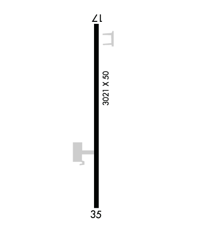
| Lat: N 3120.4 Long: W 09651.1 Elev: 411 Var: -05 Longest Runway: 3021 | ||
| CTAF: 122.9 | ||
| ||||||||||||||||||||||||||||||||
| ||||||||||||||||||||||||||||||||
| Rwy | Rwy | |||||||
| 3021x50 | 3021' | 3021x50 | 2931' | |||||
| Runway ID | Single Wheel | Double Wheel | Double Tandem Wheel | Dual Double Wheel |
| 17/35 | 4,000 | N/A | N/A | N/A |
| These numbers are Advisory and are not limits. The Airport Manager should have more accurate Weight Limits | ||||
 Airport Diagram might not be current. | |
| Facility Name: | MARLIN |
| City Name: | MARLIN |
| County: | FALLS |
| State abbrev: | TX |
| State Name: | TEXAS |
| Ownership: | PUBLICLY OWNED |
| Use: | OPEN TO THE PUBLIC |
| Owner's Name: | CITY OF MARLIN |
| Address: | PO BOX 980 |
| MARLIN, TX 76661 | |
| Owner's Phone: | 254-883-1450 |
| Manager's Name: | ANDREW POE; PUBLIC WORKS DIRECTOR. |
| Address: | PO BOX 980 |
| MARLIN, TX 76661 | |
| Phone: | 254-883-1450; EXT 237. |
| FAA Region: | SOUTHWEST |
| FAA Field Office: | TEX |
| Date | Sunrise | Sunset |
|---|---|---|
| 09/24/21 Friday | 7:17 | 19:22 |
| 09/25/21 Saturday | 7:17 | 19:20 |
| 09/26/21 Sunday | 7:18 | 19:19 |
| 09/27/21 Monday | 7:19 | 19:18 |
| 09/28/21 Tuesday | 7:19 | 19:17 |
| 09/29/21 Wednesday | 7:20 | 19:15 |
| 09/30/21 Thursday | 7:20 | 19:14 |
| 10/01/21 Friday | 7:21 | 19:13 |
| 10/02/21 Saturday | 7:22 | 19:11 |
| 10/03/21 Sunday | 7:22 | 19:10 |
| 10/04/21 Monday | 7:23 | 19:09 |
| 10/05/21 Tuesday | 7:24 | 19:08 |
| 10/06/21 Wednesday | 7:24 | 19:06 |
| 10/07/21 Thursday | 7:25 | 19:05 |
| Airport Attendance Schedule | UNATTENDED |
| Airport Status | OPERATIONAL (This Status can change at any time - please check NOTAMS) |
| Airport Lighting Schedule | SS-SR |
| Airport Storage Available | Tie Downs |
| Extra Services Available | NONE |
| Wind Indicator | YES - (lighted) |
| Control Tower | NO |
| CTAF Frequency | 122.900 |
| Unicom Frequency | |
| Rotating Beacon Color | CLEAR-GREEN (Light Land Airport) |
| Segmented Circle | YES |
| Landing Fee | NO |
| Airport Inspected | STATE - performed by STATE AERONAUTICAL PERSONNEL |
| Inspection Date | 04/16/2019 |
| Type of Fuel Available | None |
| Airframe Repair Service | NONE |
| Power Plant Repair Service | NONE |
| Latitude | N3120.4 |
| Longitude | W09651.1 (ESTIMATED) |
| Arpt Elevation | 410ft (SURVEYED) |
| Magnetic Variation | 05E |
| 3 miles NE | of MARLIN |
| Traffic Pattern Altitude | |
| Sectional Chart | HOUSTON |
| Operations (Reported) | Yearly | Avg. Daily |
|---|---|---|
| General Aviation Transient | 300 | 1 |
| General Aviation Local | 0 | 0 |
| Air Taxi | 0 | 0 |
| Commerical | 0 | 0 |
| Commuter | 0 | 0 |
| Military | 50 | 0 |
| Aircraft based on Field | |
|---|---|
| General Aviation Singles | 1 |
| General Aviation Multi | 0 |
| Jet Aircraft | 0 |
| General Aviation Helicopters | 0 |
| Military Aircraft | 0 |
| Gliders | 0 |
| Ultralights | 0 |
| FSS on field | NO |
| FSS tie-in | FORT WORTH |
| FSS Phone | 1-800-WX-BRIEF |
| Who issues Notams | FTW |
| Notam D service at airport | YES |
| ARTCC Name | FORT WORTH |
| Airport Certification | |
| Aircraft Rescue & Firefighting Index | None |
| Airport of Entry | No |
| Custom Landing Rights | No |
| Joint Civil/Military | No |
| Military Landing rights | No |
| THIS AIRPORT HAS BEEN SURVEYED BY THE NATIONAL GEODETIC SURVEY. |
| RWY 35 DSPLCD THLD MKGS NOT COINCIDENT WITH DSPLCD THLD LIGHTS. |
| FOR CD CTC FORT WORTH ARTCC AT 817-858-7584. |
| RWY 17/3 5 CRACKS W/VEGETATION GROWING THROUGH PVMNT. |
| RWY 17/3 5 RWY 17/35 NSTD LIRL NON STD FIXTURES, NON-FRANGIBLE MOUNTING. NMRS LIGHTS KNOCKED OVER. OPR STATUS OF LIGHTS UNKNOWN. VEGETATION OBSCURES LIGHTS; NORTH 2900 FT LGTD. |
Airport Communications & Frequencies:
| |||||||||||||||
| Runway: 17 | Runway: 35 | ||
| Mag heading: | 176° | Mag heading: | 356° |
| Rwy Slope: | -.28% Down | Rwy Slope: | .28% Up |
| Approach: | Approach: | ||
| Pattern: | Left Traffic | Pattern: | Left Traffic |
| Markings: | BASIC | Markings: | BASIC |
| Marking Condition: | POOR; MKGS FADED. | Marking Condition: | POOR; MKGS FADED. NSTD DSPLCD THLD MKGS YELLOW. |
| Arresting Dev: | Arresting Dev: | ||
| Lat & Long: | N3120.7 W09651.1 | Lat. & Long.: | N3120.2 W09651.1 |
| Elev: | 410.4 ft. MSL | Elev: | 401.9 ft. MSL |
| TCH: | TCH: | ||
| Visual Glide Path: | Visual Glide Path: | ||
| Displaced Threshold: | No | Displaced Threshold: | 90 feet |
| Touchdown Zone: | YES | Touchdown Zone: | YES |
| Touchdown Elev.: | 410.7 feet | Touchdown Elev.: | 410.7 feet |
| Visual Glide Slope: | Visual Glide Slope: | ||
| RVR Equipment: | RVR Equipment: | ||
| RVV Equipment: | NO | RVV Equipment: | NO |
| Approach Lights: | Approach Lights: | ||
| REIL: | NO | REIL: | NO |
| Centerline Lights: | NO | Centerline Lights: | NO |
| Touchdown lights: | NO | Touchdown lights: | NO |
| Runway Category: | Runway with a Visual Approach | Runway Category: | Runway with a Visual Approach |
| Declared Distances: | Declared Distances: | ||
| Obstructions: | TREES | Obstructions: | FENCE |
| Marked: | NOT Marked/Lighted | Marked: | NOT Marked/Lighted |
| Clearance slope: | 15:1 | Clearance slope: | APCH RATIO 5:1 TO DSPLCD THLD +15 FT BRUSH 80 FT FM DSPLCD THLD 50 FT RIGHT OF CNTRLN. |
| Obstruction height: | 54 feet AGL | Obstruction height: | 8 feet AGL |
| Dist. from runway: | 1030 feet | Dist. from runway: | 201 feet |
| Centerline offset: | Centerline offset: | 75 feet right of centerline | |
| Comments: | +8 FT BRUSH 60 FT FM THLD 100 FT L OF CNTRLN. | Comments: | +8 FT FENCE 50 FT RIGHT & 80-200 FT SOUTH OF DSPLCD THLD. |
Thanks for using FltPlan.com
all rights reserved © 1999-2021 by Flight Plan LLC
