
| TUBA CITY TUBA CITY AZ |
| |
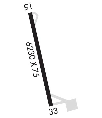
| Lat: N 3605.6 Long: W 11123.0 Elev: 4513 Var: -13 Longest Runway: 6230 | ||
| CTAF: 122.9 | ||
| |||||
|
| Rwy | Rwy | |||||||
| 6230x75 | 6230' | 6230x75 | 6230' | |||||
| Runway ID | Single Wheel | Double Wheel | Double Tandem Wheel | Dual Double Wheel |
| 15/33 | 12,500 | N/A | N/A | N/A |
| These numbers are Advisory and are not limits. The Airport Manager should have more accurate Weight Limits | ||||
| FltPlan does not have IFR approach charts available for KT03. |
 Airport Diagram might not be current. | |
| Facility Name: | TUBA CITY |
| City Name: | TUBA CITY |
| County: | COCONINO |
| State abbrev: | AZ |
| State Name: | ARIZONA |
| Ownership: | PUBLICLY OWNED |
| Use: | OPEN TO THE PUBLIC |
| Owner's Name: | NAVAJO NATION C/O NAVAJO DOT |
| Address: | PO BOX 4620 |
| WINDOW ROCK, AZ 86515 | |
| Owner's Phone: | 928-871-6164 |
| Manager's Name: | KYRON HARDY |
| Address: | PO BOX 4620 |
| WINDOW ROCK, AZ 86515 | |
| Phone: | 505-371-8323; 928-797-1684. |
| FAA Region: | WESTERN-PACIFIC |
| FAA Field Office: | PHX |
| Date | Sunrise | Sunset |
|---|---|---|
| 06/08/26 Monday | 6:08 | 20:41 |
| 06/09/26 Tuesday | 6:08 | 20:42 |
| 06/10/26 Wednesday | 6:08 | 20:42 |
| 06/11/26 Thursday | 6:08 | 20:42 |
| 06/12/26 Friday | 6:08 | 20:43 |
| 06/13/26 Saturday | 6:08 | 20:43 |
| 06/14/26 Sunday | 6:08 | 20:44 |
| 06/15/26 Monday | 6:08 | 20:44 |
| 06/16/26 Tuesday | 6:08 | 20:44 |
| 06/17/26 Wednesday | 6:08 | 20:45 |
| 06/18/26 Thursday | 6:08 | 20:45 |
| 06/19/26 Friday | 6:08 | 20:45 |
| 06/20/26 Saturday | 6:09 | 20:46 |
| 06/21/26 Sunday | 6:09 | 20:46 |
| Airport Attendance Schedule | UNATTENDED |
| Airport Status | OPERATIONAL (This Status can change at any time - please check NOTAMS) |
| Airport Lighting Schedule | ACTVT PAPI RWY 15 & 33; MIRL RWY 15/33 - CTAF. |
| Airport Storage Available | Tie Downs |
| Extra Services Available | NONE |
| Wind Indicator | YES - (lighted) |
| Control Tower | NO |
| CTAF Frequency | 122.900 |
| Unicom Frequency | |
| Rotating Beacon Color | WG |
| Segmented Circle | YES |
| Landing Fee | NO |
| Airport Inspected | STATE - performed by PRIVATE CONTRACT PERSONNEL |
| Inspection Date | 04/18/2025 |
| Type of Fuel Available | None |
| Airframe Repair Service | None |
| Power Plant Repair Service | None |
| Latitude | N3605.6 |
| Longitude | W11123.0 (ESTIMATED) |
| Arpt Elevation | 4513ft (ESTIMATED) |
| Magnetic Variation | 13E |
| 5 miles W | of TUBA CITY |
| Traffic Pattern Altitude | |
| Sectional Chart | LAS VEGAS |
| Operations (Reported) | Yearly | Avg. Daily |
|---|---|---|
| General Aviation Transient | 0 | 0 |
| General Aviation Local | 0 | 0 |
| Air Taxi | 0 | 0 |
| Commerical | 0 | 0 |
| Commuter | 0 | 0 |
| Military | 0 | 0 |
| Aircraft based on Field | |
|---|---|
| General Aviation Singles | 0 |
| General Aviation Multi | 0 |
| Jet Aircraft | 0 |
| General Aviation Helicopters | 0 |
| Military Aircraft | 0 |
| Gliders | 0 |
| Ultralights | 0 |
| FSS on field | NO |
| FSS tie-in | PRESCOTT |
| FSS Phone | 1-800-WX-BRIEF |
| Who issues Notams | PRC |
| Notam D service at airport | YES |
| ARTCC Name | DENVER |
| Airport Certification | |
| Aircraft Rescue & Firefighting Index | None |
| Airport of Entry | No |
| Custom Landing Rights | No |
| Joint Civil/Military | No |
| Military Landing rights | No |
| NATIONAL PLAN OF INTEGRATED AIRPORT SYSTEMS (NPIAS) |
| LIVESTOCK ON ARPT. |
| ARPT ACES - INDIAN HEALTH SVCS 928-283-2501. |
| RWY 15/3 3 N 1500 FT HAS +10 IN UNDULATIONS. |
Airport Communications & Frequencies:
| |||||||
| Runway: 15 | Runway: 33 | ||
| Mag heading: | 153° | Mag heading: | 333° |
| Rwy Slope: | -.91% Down | Rwy Slope: | .91% Up |
| Approach: | Approach: | ||
| Pattern: | Left Traffic | Pattern: | Left Traffic |
| Markings: | NONPRECISION INSTRUMENT | Markings: | NONPRECISION INSTRUMENT |
| Marking Condition: | GOOD | Marking Condition: | GOOD |
| Arresting Dev: | Arresting Dev: | ||
| Lat & Long: | N3606.1 W11123.1 | Lat. & Long.: | N3605.1 W11122.8 |
| Elev: | 4512.0 ft. MSL | Elev: | 4455.0 ft. MSL |
| TCH: | 40 ft. AGL | TCH: | 40 ft. AGL |
| Visual Glide Path: | 3.00 degrees | Visual Glide Path: | 3.00 degrees |
| Displaced Threshold: | No | Displaced Threshold: | No |
| Touchdown Zone: | NO | Touchdown Zone: | NO |
| Touchdown Elev.: | Touchdown Elev.: | ||
| Visual Glide Slope: | 2-Light PAPI on LEFT side of Runway | Visual Glide Slope: | 2-Light PAPI on LEFT side of Runway |
| RVR Equipment: | RVR Equipment: | ||
| RVV Equipment: | NO | RVV Equipment: | NO |
| Approach Lights: | Approach Lights: | ||
| REIL: | NO | REIL: | NO |
| Centerline Lights: | NO | Centerline Lights: | NO |
| Touchdown lights: | NO | Touchdown lights: | NO |
| Runway Category: | Runway with a Visual Approach | Runway Category: | Runway with a Visual Approach |
| Declared Distances: | Declared Distances: |
Thanks for using FltPlan.com
all rights reserved © 1999-2026 by Flight Plan LLC
