
| HUNTER AAF SAVANNAH GA |
| |
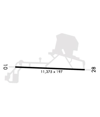
| Lat: N 3200.6 Long: W 08108.8 Elev: 41 Var: +04 Longest Runway: 11375 | ||
| Dept. ATIS: 127.52 Arr. ATIS: 127.52 Ground: 121.8 Tower: 124.97 | ||
| ||||||
|
| Rwy | Rwy | |||||||
| 11375x197 | 11375' | 11375x197 | 11375' | 109.50 - 276° | ||||
| Runway ID | Single Wheel | Double Wheel | Double Tandem Wheel | Dual Double Wheel |
| 10/28 | N/A | N/A | N/A | N/A |
| These numbers are Advisory and are not limits. The Airport Manager should have more accurate Weight Limits | ||||
 Airport Diagram might not be current. | |
| Facility Name: | HUNTER AAF |
| City Name: | SAVANNAH |
| County: | CHATHAM |
| State abbrev: | GA |
| State Name: | GEORGIA |
| Ownership: | ARMY OWNED |
| Use: | PRIVATE |
| Owner's Name: | USAASA ATTN: ATAS-AS |
| Address: | 9325 GUNSTON RD, BLDG 1466 SUITE N319 |
| ALEXANDRIA, VA 22060-5582 | |
| Owner's Phone: | |
| Manager's Name: | |
| Address: | |
| Phone: | |
| FAA Region: | SOUTHERN |
| FAA Field Office: | ATL |
| Date | Sunrise | Sunset |
|---|---|---|
| 09/24/21 Friday | 7:14 | 19:19 |
| 09/25/21 Saturday | 7:14 | 19:18 |
| 09/26/21 Sunday | 7:15 | 19:16 |
| 09/27/21 Monday | 7:16 | 19:15 |
| 09/28/21 Tuesday | 7:16 | 19:14 |
| 09/29/21 Wednesday | 7:17 | 19:12 |
| 09/30/21 Thursday | 7:18 | 19:11 |
| 10/01/21 Friday | 7:18 | 19:10 |
| 10/02/21 Saturday | 7:19 | 19:08 |
| 10/03/21 Sunday | 7:20 | 19:07 |
| 10/04/21 Monday | 7:20 | 19:06 |
| 10/05/21 Tuesday | 7:21 | 19:05 |
| 10/06/21 Wednesday | 7:22 | 19:03 |
| 10/07/21 Thursday | 7:22 | 19:02 |
| Airport Attendance Schedule | CONTINUOUS |
| Airport Status | OPERATIONAL (This Status can change at any time - please check NOTAMS) |
| Airport Lighting Schedule | ACTVT-3 STEP APCH LGTS & HIRL RY 10-28, REIL RY 10, PAPI RY 10 & 28 - CTAF WHEN TWR CLSD. |
| Airport Storage Available | NONE |
| Extra Services Available | NONE |
| Wind Indicator | NONE |
| Control Tower | YES |
| CTAF Frequency | 124.975 |
| Unicom Frequency | |
| Rotating Beacon Color | SPLIT-CLEAR-GREEN (LIGHTED MILITARY AIRPORT) |
| Segmented Circle | NO |
| Landing Fee |
| Airport Inspected | No Inspection Data Available performed by the OWNER |
| Inspection Date | Unknown |
| Type of Fuel Available | None |
| Airframe Repair Service | None |
| Power Plant Repair Service | None |
| Latitude | N3200.6 |
| Longitude | W08108.8 (ESTIMATED) |
| Arpt Elevation | 41ft (ESTIMATED) |
| Magnetic Variation | 04W |
| 2 miles SW | of SAVANNAH |
| Traffic Pattern Altitude | |
| Sectional Chart | ATLANTA |
| Operations (Reported) | Yearly | Avg. Daily |
|---|---|---|
| General Aviation Transient | 0 | 0 |
| General Aviation Local | 0 | 0 |
| Air Taxi | 0 | 0 |
| Commerical | 0 | 0 |
| Commuter | 0 | 0 |
| Military | 0 | 0 |
| Aircraft based on Field | |
|---|---|
| General Aviation Singles | 0 |
| General Aviation Multi | 0 |
| Jet Aircraft | 0 |
| General Aviation Helicopters | 0 |
| Military Aircraft | 0 |
| Gliders | 0 |
| Ultralights | 0 |
| FSS on field | NO |
| FSS tie-in | MACON |
| FSS Phone | 1-800-WX-BRIEF |
| Who issues Notams | SVN |
| Notam D service at airport | YES |
| ARTCC Name | JACKSONVILLE |
| Airport Certification | |
| Aircraft Rescue & Firefighting Index | None |
| Airport of Entry | No |
| Custom Landing Rights | No |
| Joint Civil/Military | No |
| Military Landing rights | No |
| JASU: 3(AF M32A-86) 3(DND CE12 EQUIVALENT) 1(DND CE14 EQUIVALENT) 1(AF M32-95) |
| FUEL: J8, JET A++. TRAN FUEL PPR, CTC BASE OPS C912-315-5110.5531, DSN 729-2110/5531. TRAN ACFT MAY EXP DELAY DUE TO OPR MSN. |
| OIL: O-156 |
| TRAN ALERT: LTD SVC AVBL 1230Z++MON-0400Z++ SAT, EXC HOL. |
| CAUTION: WILDLIFE HAZ. SEAGULL HAZ. |
| TFC PAT: F/W 1500 FT, R/W 700 FT. |
| MISC: R/W PILOTS PLANNING TO CONDUCT OPR WITHIN R3005 MUST RCV A RNG BRIEFING PRIOR TO OPR. BRIEFING SHALL BE ACCOMPLISHED AT LEAST 4 HR PRIOR TO FLT ON THE RESERVATION. AVIATORS BRIEFED WITHIN THE PAST 6 MONTHS MAY RCV FONE UPDATE. |
| MISC: FOR BRIEFING COORD CTC DSN 729-2523/6207, C912-315-2523, 1300-2100Z++ MON-FRI EXC HOL. BASE OPS OPR 24/7, WX OBSERVER OPR 1230Z++ MON-0400Z++ SAT, EXE HOL. OT, EXCLD HOL. NO EMERG SVC AVBL WHEN TWR AND BASE OPS CLSD. |
| RADAR: SEE TERMINAL FLIP FOR RADAR MINIMA. |
| SEE FLIP AP/1 SUPPLEMENTARY ARPT |
| CAUTION: TAXIWAY 7E/W CLSD. NO R/W HOVERING ON WEST RAMP WITHOUT PRIOR PERMISSION. |
| ARNGOPS CTC DSN 729-7182/6534, C912-315-7182/6534. |
| RSTD: AFLD CLSD 0400Z++ SAT THRU 1230Z++ MON TO TRAN F/W ACFT EXC FOR OFFL BUS ONLY. PPR FOR ALL TRAN ACFT TO INCL TOUCH AND GO OPS, CTC BASE OPS DSN 729-5110, C912-315-5110. |
| MISC: FULL WX SVC 24/7 INCL HOL, DSN 729-5467/5027, C912-315-5467/5027. OT REMOTE BRIEFING FR 26 OWS BARKSDALE AFB, LA, DSN 331-2651/2/3, C318-529-2651/2/3. PRIM WX SENSORS IN USE AN/FMQ-19 AUTOMATED FULL TIME AND AUGMENT AS RQR. DUR PERIODS OF AUGMENT, ATC WILL ASSIST IN COOPERATIVE WATCH BY NOTIFYING WX OF UNREPORTED WX COND. AUGMENTATION/BACK-UP MODE, PREVAIL SFC VIS MAY NOT REPRESENT ENTIRE AFLD, FR 330 - 090 DEGS DUE TO BLDG OBST AND LACK OF VIS MARK BYD 1/4 SM. PMSV AVBL DUR OPR HR. |
| COMPASS ROSE CALIBRATION OTS. |
| ARNG: BASE OPS CTC DSN 729-7182/6534, C912-315-7182/6534. |
| NS ABTMT: PROCEDURES IN EFFECT 0300Z-1200Z++ MON-SAT; 0300Z-1800Z++ SUN. PRACTICE MULTIPLE CIRCLING APCH CAT C, D, E NOT AUTH BLW 1500 FT. NO OVFT OF SAVANNAH AND SUR POPULATED AREAS BLW 1000 FT UNLESS ON APCH TO HUNTER AAF. QUIET HR 0230-1030Z++. |
Airport Communications & Frequencies:
| |||||||||||||||||||||||||||||||
| Runway: 10 | Runway: 28 | ||
| Mag heading: | 96° | Mag heading: | 276° |
| Rwy Slope: | .08% Up | Rwy Slope: | -.08% Down |
| Approach: | Approach: | ILS/DME | |
| Pattern: | Left Traffic | Pattern: | Left Traffic |
| Markings: | Markings: | ||
| Marking Condition: | Marking Condition: | ||
| Arresting Dev: | Arresting Dev: | ||
| Lat & Long: | N3200.6 W08109.9 | Lat. & Long.: | N3200.6 W08107.7 |
| Elev: | 17.4 ft. MSL | Elev: | 26.5 ft. MSL |
| TCH: | 55 ft. AGL | TCH: | 54 ft. AGL |
| Visual Glide Path: | 3.00 degrees | Visual Glide Path: | 3.00 degrees |
| Displaced Threshold: | No | Displaced Threshold: | No |
| Touchdown Zone: | YES | Touchdown Zone: | YES |
| Touchdown Elev.: | 25.9 feet | Touchdown Elev.: | 41.3 feet |
| Visual Glide Slope: | 4-Light PAPI on RIGHT side of Runway | Visual Glide Slope: | 4-Light PAPI on LEFT side of Runway |
| RVR Equipment: | TOUCHDOWN | RVR Equipment: | ROLLOUT |
| RVV Equipment: | NO | RVV Equipment: | NO |
| Approach Lights: | Approach Lights: | ALSF1 - standard 2,400 foot high intensity approach lighting system with sequenced flashers, Category I | |
| REIL: | YES | REIL: | NO |
| Centerline Lights: | NO | Centerline Lights: | NO |
| Touchdown lights: | NO | Touchdown lights: | NO |
| Runway Category: | Runway Category: | ||
| Declared Distances: | Declared Distances: |
Thanks for using FltPlan.com
all rights reserved © 1999-2021 by Flight Plan LLC
