| GRANT COUNTY SILVER CITY NM |
| |
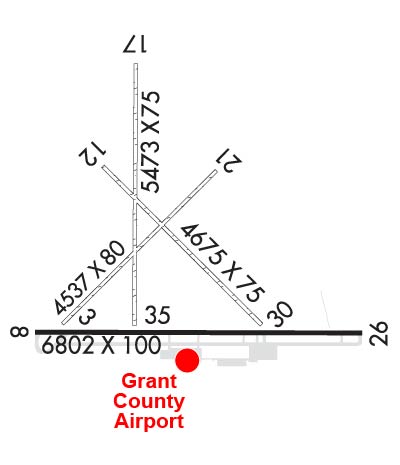
| Lat: N 3238.2 Long: W 10809.4 Elev: 5446 Var: -08 Longest Runway: 6803 | ||
| AWOS: 126.72 CTAF: 122.8 | ||
| |||||||||||||||||||||||
| |||||||||||||||||||||||
| |||||||||||||||||||||||
| Rwy | Rwy | |||||||
| 4537x80 | 4537' | 4537x80 | 4537' | |||||
| 6803x100 | 6803' | 6803x100 | 6803' | 111.70 - 262° | ||||
| 4675x75 | 4675' | 4675x75 | 4675' | |||||
| 5473x75 | 5364' | 5473x75 | 5473' | |||||
| Runway ID | Single Wheel | Double Wheel | Double Tandem Wheel | Dual Double Wheel |
| 03/21 | N/A | N/A | N/A | N/A |
| 08/26 | 75,000 | 100,000 | N/A | N/A |
| 12/30 | N/A | N/A | N/A | N/A |
| 17/35 | N/A | N/A | N/A | N/A |
| These numbers are Advisory and are not limits. The Airport Manager should have more accurate Weight Limits | ||||
 Airport Diagram might not be current. | |
| Facility Name: | GRANT COUNTY |
| City Name: | SILVER CITY |
| County: | GRANT |
| State abbrev: | NM |
| State Name: | NEW MEXICO |
| Ownership: | PUBLICLY OWNED |
| Use: | OPEN TO THE PUBLIC |
| Owner's Name: | GRANT COUNTY |
| Address: | P.O. BOX 6, 182 AIRPORT RD. |
| HURLEY, NM 88043 | |
| Owner's Phone: | 575-313-9784 |
| Manager's Name: | REBEKAH WENGER |
| Address: | PO BOX 6 182 AIRPORT ROAD |
| HURLEY, NM 88043 | |
| Phone: | 575-313-9784 |
| FAA Region: | SOUTHWEST |
| FAA Field Office: | LNM |
| Date | Sunrise | Sunset |
|---|---|---|
| 06/08/26 Monday | 6:05 | 20:19 |
| 06/09/26 Tuesday | 6:04 | 20:19 |
| 06/10/26 Wednesday | 6:04 | 20:20 |
| 06/11/26 Thursday | 6:04 | 20:20 |
| 06/12/26 Friday | 6:04 | 20:21 |
| 06/13/26 Saturday | 6:04 | 20:21 |
| 06/14/26 Sunday | 6:04 | 20:21 |
| 06/15/26 Monday | 6:04 | 20:22 |
| 06/16/26 Tuesday | 6:05 | 20:22 |
| 06/17/26 Wednesday | 6:05 | 20:22 |
| 06/18/26 Thursday | 6:05 | 20:23 |
| 06/19/26 Friday | 6:05 | 20:23 |
| 06/20/26 Saturday | 6:05 | 20:23 |
| 06/21/26 Sunday | 6:05 | 20:23 |
| Airport Attendance Schedule | 7 Days A Week 0600-1700 |
| Airport Status | OPERATIONAL (This Status can change at any time - please check NOTAMS) |
| Airport Lighting Schedule | ACTVT MALS RWY 26; REIL RWY 08; MIRL RWY 08/26 - CTAF. |
| Airport Storage Available | Tie Downs |
| Extra Services Available | Charter |
| Wind Indicator | YES - (lighted) |
| Control Tower | NO |
| CTAF Frequency | 122.800 |
| Unicom Frequency | 122.800 |
| Rotating Beacon Color | WG |
| Segmented Circle | YES |
| Landing Fee | NO |
| Airport Inspected | STATE - performed by FAA AIRPORTS FIELD PERSONNEL |
| Inspection Date | 03/12/2026 |
| Type of Fuel Available | Grade 100LL, JET A-1 (freeze point -50C) |
| Airframe Repair Service | None |
| Power Plant Repair Service | None |
| Latitude | N3238.2 |
| Longitude | W10809.4 (ESTIMATED) |
| Arpt Elevation | 5445ft (SURVEYED) |
| Magnetic Variation | 08E |
| 10 miles SE | of SILVER CITY |
| Traffic Pattern Altitude | |
| Sectional Chart | ALBUQUERQUE |
| Operations (Reported) | Yearly | Avg. Daily |
|---|---|---|
| General Aviation Transient | 0 | 0 |
| General Aviation Local | 0 | 0 |
| Air Taxi | 0 | 0 |
| Commerical | 0 | 0 |
| Commuter | 0 | 0 |
| Military | 0 | 0 |
| Aircraft based on Field | |
|---|---|
| General Aviation Singles | 0 |
| General Aviation Multi | 0 |
| Jet Aircraft | 0 |
| General Aviation Helicopters | 0 |
| Military Aircraft | 0 |
| Gliders | 0 |
| Ultralights | 0 |
| FSS on field | NO |
| FSS tie-in | ALBUQUERQUE |
| FSS Phone | 1-800-WX-BRIEF |
| Who issues Notams | SVC |
| Notam D service at airport | YES |
| ARTCC Name | ALBUQUERQUE |
| Airport Certification | AIRPORT RECEIVING SCHEDULED AIR CARRIER SERVICE FROM CARRIERS CERTIFICATED BY THE CIVIL AERONAUTICS BOARD |
| Aircraft Rescue & Firefighting Index | AIRPORT HAS A CERTIFICATE UNDER CFR PART 139 |
| Airport of Entry | No |
| Custom Landing Rights | No |
| Joint Civil/Military | No |
| Military Landing rights | YES |
| NATIONAL PLAN OF INTEGRATED AIRPORT SYSTEMS (NPIAS) |
| GRANT AGREEMENTS UNDER FAAP/ADAP/AIP |
| ASSURANCES PURSUANT TO TITLE VI, CIVIL RIGHTS ACT OF 1964 |
| 5621 FT CRANE NE OF ARPT 8800 FT FM RWY 26 ON CNTRLN. |
| FOR CD IF UNA TO CTC ON FSS FREQ, CTC ALBUQUERQUE ARTCC AT 505-856-4561. |
| TWY A2, A3 & A4 UNUSBL COCKPIT TO MAIN GEAR LEN OVR 40 FT. |
| RWY 03/2 1 DALGT VFR COND ONLY. |
| RWY 12/3 0 DALGT VFR COND ONLY. |
| RWY 17/3 5 DALGT VFR COND ONLY. |
| RWY 08/2 6 PCR VALUE: 230/F/C/X/T |
Airport Communications & Frequencies:
| |||||||||
| Runway: 03 | Runway: 21 | ||
| Mag heading: | 37° | Mag heading: | 217° |
| Rwy Slope: | .62% Up | Rwy Slope: | -.62% Down |
| Approach: | Approach: | ||
| Pattern: | Left Traffic | Pattern: | Left Traffic |
| Markings: | Markings: | ||
| Marking Condition: | Marking Condition: | ||
| Arresting Dev: | Arresting Dev: | ||
| Lat & Long: | N3238.0 W10809.8 | Lat. & Long.: | N3238.5 W10809.2 |
| Elev: | 5382.8 ft. MSL | Elev: | 5410.8 ft. MSL |
| TCH: | TCH: | ||
| Visual Glide Path: | Visual Glide Path: | ||
| Displaced Threshold: | No | Displaced Threshold: | No |
| Touchdown Zone: | NO | Touchdown Zone: | NO |
| Touchdown Elev.: | Touchdown Elev.: | ||
| Visual Glide Slope: | Visual Glide Slope: | ||
| RVR Equipment: | RVR Equipment: | ||
| RVV Equipment: | NO | RVV Equipment: | NO |
| Approach Lights: | Approach Lights: | ||
| REIL: | NO | REIL: | NO |
| Centerline Lights: | NO | Centerline Lights: | NO |
| Touchdown lights: | NO | Touchdown lights: | NO |
| Runway Category: | Runway with a Visual Approach | Runway Category: | Runway with a Visual Approach |
| Declared Distances: | Declared Distances: | ||
| Obstructions: | POLE | Obstructions: | FENCE |
| Marked: | NOT Marked/Lighted | Marked: | NOT Marked/Lighted |
| Clearance slope: | 22:1 | Clearance slope: | |
| Obstruction height: | 35 feet AGL | Obstruction height: | 4 feet AGL |
| Dist. from runway: | 800 feet | Dist. from runway: | 0 feet |
| Centerline offset: | 250 right of centerline | Centerline offset: | |
| Comments: | Comments: |
| Runway: 08 | Runway: 26 | ||
| Mag heading: | 82° | Mag heading: | 262° |
| Rwy Slope: | -.14% Down | Rwy Slope: | .14% Up |
| Approach: | Approach: | LOC/DME | |
| Pattern: | Left Traffic | Pattern: | Left Traffic |
| Markings: | NONPRECISION INSTRUMENT | Markings: | NONPRECISION INSTRUMENT |
| Marking Condition: | GOOD | Marking Condition: | GOOD |
| Arresting Dev: | Arresting Dev: | ||
| Lat & Long: | N3237.9 W10809.9 | Lat. & Long.: | N3237.9 W10808.6 |
| Elev: | 5386.2 ft. MSL | Elev: | 5376.5 ft. MSL |
| TCH: | 44 ft. AGL | TCH: | 45 ft. AGL |
| Visual Glide Path: | 3.00 degrees | Visual Glide Path: | 3.00 degrees |
| Displaced Threshold: | No | Displaced Threshold: | No |
| Touchdown Zone: | YES | Touchdown Zone: | YES |
| Touchdown Elev.: | 5386.1 feet | Touchdown Elev.: | 5380.0 feet |
| Visual Glide Slope: | 4-Light PAPI on LEFT side of Runway | Visual Glide Slope: | 4-Light PAPI on LEFT side of Runway |
| RVR Equipment: | RVR Equipment: | ||
| RVV Equipment: | NO | RVV Equipment: | NO |
| Approach Lights: | Approach Lights: | MALS - 1,400 foot medium intensity approach lighting system | |
| REIL: | YES; 39 INCHES TALL LOCTD 9 FT FM THE EDGE OF TWY A5. | REIL: | NO |
| Centerline Lights: | NO | Centerline Lights: | NO |
| Touchdown lights: | NO | Touchdown lights: | NO |
| Runway Category: | Runway with a Non-precision Approach having visibility minimums greater than 3/4 mile | Runway Category: | D |
| Declared Distances: | Declared Distances: |
| Runway: 12 | Runway: 30 | ||
| Mag heading: | 127° | Mag heading: | 307° |
| Rwy Slope: | -1.07% Down | Rwy Slope: | 1.07% Up |
| Approach: | Approach: | ||
| Pattern: | Left Traffic | Pattern: | Left Traffic |
| Markings: | Markings: | ||
| Marking Condition: | Marking Condition: | ||
| Arresting Dev: | Arresting Dev: | ||
| Lat & Long: | N3238.5 W10809.6 | Lat. & Long.: | N3238.0 W10809.0 |
| Elev: | 5424.8 ft. MSL | Elev: | 5374.8 ft. MSL |
| TCH: | TCH: | ||
| Visual Glide Path: | Visual Glide Path: | ||
| Displaced Threshold: | No | Displaced Threshold: | No |
| Touchdown Zone: | NO | Touchdown Zone: | NO |
| Touchdown Elev.: | Touchdown Elev.: | ||
| Visual Glide Slope: | Visual Glide Slope: | ||
| RVR Equipment: | RVR Equipment: | ||
| RVV Equipment: | NO | RVV Equipment: | NO |
| Approach Lights: | Approach Lights: | ||
| REIL: | NO | REIL: | NO |
| Centerline Lights: | NO | Centerline Lights: | NO |
| Touchdown lights: | NO | Touchdown lights: | NO |
| Runway Category: | Runway with a Visual Approach | Runway Category: | Runway with a Visual Approach |
| Declared Distances: | Declared Distances: | ||
| Obstructions: | FENCE | Obstructions: | TOWER |
| Marked: | NOT Marked/Lighted | Marked: | LIGHTED |
| Clearance slope: | 20:1 | Clearance slope: | 26:1 |
| Obstruction height: | 5 feet AGL | Obstruction height: | 30 feet AGL |
| Dist. from runway: | 100 feet | Dist. from runway: | 800 feet |
| Centerline offset: | Centerline offset: | 100 feet right of centerline | |
| Comments: | Comments: |
| Runway: 17 | Runway: 35 | ||
| Mag heading: | 172° | Mag heading: | 352° |
| Rwy Slope: | -1.09% Down | Rwy Slope: | 1.09% Up |
| Approach: | Approach: | ||
| Pattern: | Left Traffic | Pattern: | Left Traffic |
| Markings: | Markings: | ||
| Marking Condition: | Marking Condition: | ||
| Arresting Dev: | Arresting Dev: | ||
| Lat & Long: | N3238.9 W10809.5 | Lat. & Long.: | N3238.0 W10809.5 |
| Elev: | 5445.6 ft. MSL | Elev: | 5385.8 ft. MSL |
| TCH: | TCH: | ||
| Visual Glide Path: | Visual Glide Path: | ||
| Displaced Threshold: | 109 feet; DTHR MKD BY TIRES. | Displaced Threshold: | No |
| Touchdown Zone: | NO | Touchdown Zone: | NO |
| Touchdown Elev.: | Touchdown Elev.: | ||
| Visual Glide Slope: | Visual Glide Slope: | ||
| RVR Equipment: | RVR Equipment: | ||
| RVV Equipment: | NO | RVV Equipment: | NO |
| Approach Lights: | Approach Lights: | ||
| REIL: | NO | REIL: | NO |
| Centerline Lights: | NO | Centerline Lights: | NO |
| Touchdown lights: | NO | Touchdown lights: | NO |
| Runway Category: | Runway with a Visual Approach | Runway Category: | Runway with a Visual Approach |
| Declared Distances: | Declared Distances: | ||
| Obstructions: | FENCE | Obstructions: | PLINE |
| Marked: | NOT Marked/Lighted | Marked: | MARKED |
| Clearance slope: | APCH RATIO 16:1 FM DTHR. | Clearance slope: | 28:1 |
| Obstruction height: | 6 feet AGL | Obstruction height: | 35 feet AGL |
| Dist. from runway: | 0 feet | Dist. from runway: | 1000 feet |
| Centerline offset: | Centerline offset: | ||
| Comments: | Comments: |
Thanks for using FltPlan.com
all rights reserved © 1999-2026 by Flight Plan LLC