
| SPIRIT OF ST LOUIS ST LOUIS MO |
| |
| Lat: N 3839.7 Long: W 09039.1 Elev: 463 Var: +01 Longest Runway: 7486 | ||
| Clr Del: 133.1 Dept. ATIS: 134.8 Arr. ATIS: 134.8 Ground: 121.7 Tower: 124.75 | ||

| |||||||||||||||||||||||||||||||||||||||||||||||||||||||||||||||||||||
| |||||||||||||||||||||||||||||||||||||||||||||||||||||||||||||||||||||
| |||||||||||||||||||||||||||||||||||||||||||||||||||||||||||||||||||||
| |||||||||||||||||||||||||||||||||||||||||||||||||||||||||||||||||||||
| |||||||||||||||||||||||||||||||||||||||||||||||||||||||||||||||||||||
| |||||||||||||||||||||||||||||||||||||||||||||||||||||||||||||||||||||
| |||||||||||||||||||||||||||||||||||||||||||||||||||||||||||||||||||||
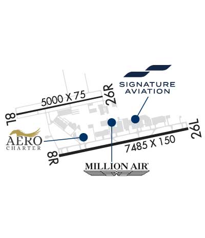
| Rwy | Rwy | |||||||
| 5000x75 | 5000' | 5000x75 | 5000' | |||||
| 7486x150 | 7486' | 110.55 - 079° | 7486x150 | 7005' | 111.10 - 259° | |||
| Runway ID | Single Wheel | Double Wheel | Double Tandem Wheel | Dual Double Wheel |
| 08L/26R | N/A | N/A | 45,500 | N/A |
| 08R/26L | 33,000 | 100,000 | N/A | N/A |
| These numbers are Advisory and are not limits. The Airport Manager should have more accurate Weight Limits | ||||
 Airport Diagram might not be current. | |
| Facility Name: | SPIRIT OF ST LOUIS |
| City Name: | ST LOUIS |
| County: | ST LOUIS |
| State abbrev: | MO |
| State Name: | MISSOURI |
| Ownership: | PUBLICLY OWNED |
| Use: | OPEN TO THE PUBLIC |
| Owner's Name: | ST LOUIS COUNTY |
| Address: | 18270 EDISON AVE NR 100 |
| CHESTERFIELD, MO 63005-3704 | |
| Owner's Phone: | 636-532-2222 |
| Manager's Name: | MR. JOHN D. BALES |
| Address: | SPIRIT OF ST LOUIS AIRPORT, 18270 EDISON AVENUE |
| CHESTERFIELD, MO 63005-3704 | |
| Phone: | 636-532-2222 |
| FAA Region: | CENTRAL |
| FAA Field Office: | NONE |
| Date | Sunrise | Sunset |
|---|---|---|
| 06/08/26 Monday | 5:38 | 20:26 |
| 06/09/26 Tuesday | 5:38 | 20:26 |
| 06/10/26 Wednesday | 5:38 | 20:27 |
| 06/11/26 Thursday | 5:37 | 20:27 |
| 06/12/26 Friday | 5:37 | 20:28 |
| 06/13/26 Saturday | 5:37 | 20:28 |
| 06/14/26 Sunday | 5:37 | 20:28 |
| 06/15/26 Monday | 5:37 | 20:29 |
| 06/16/26 Tuesday | 5:37 | 20:29 |
| 06/17/26 Wednesday | 5:37 | 20:30 |
| 06/18/26 Thursday | 5:38 | 20:30 |
| 06/19/26 Friday | 5:38 | 20:30 |
| 06/20/26 Saturday | 5:38 | 20:30 |
| 06/21/26 Sunday | 5:38 | 20:31 |
| Airport Attendance Schedule | CONTINUOUS |
| Airport Status | OPERATIONAL (This Status can change at any time - please check NOTAMS) |
| Airport Lighting Schedule | ATC-CTL. HIRL RY 08R/26L PRESET ON MED INTST 2300-0600; MIRL RY 08L/26R PRESET ON LOW INTST 2300-0600. TO INCR INTST AFT 2300 AND ACTVT MALSR RY 08R & 26L - CTAF. |
| Airport Storage Available | Tie Downs, Hanger |
| Extra Services Available | Air Freight, Air Ambulance, Avionics, Charter, Flight Instruction, Aircraft Rental, Aircraft Sales, Annual Surveying |
| Wind Indicator | YES - (unlit) |
| Control Tower | YES |
| CTAF Frequency | 124.750 |
| Unicom Frequency | 122.950 |
| Rotating Beacon Color | WG |
| Segmented Circle | NO |
| Landing Fee | NO |
| Airport Inspected | STATE - performed by FAA AIRPORTS FIELD PERSONNEL |
| Inspection Date | 02/24/2026 |
| Type of Fuel Available | Grade 100LL, JET A (freeze point -40C) |
| Airframe Repair Service | MAJOR |
| Power Plant Repair Service | MAJOR |
| Latitude | N3839.7 |
| Longitude | W09039.1 (ESTIMATED) |
| Arpt Elevation | 463ft (SURVEYED) |
| Magnetic Variation | 01W |
| 17 miles W | of ST LOUIS |
| Traffic Pattern Altitude | 1273; TPA RWY 08R/26L PROP 1237 FT AGL, RWY 08L/26R PROP 837 FT AGL. TPA JETS 1537 FT AGL. |
| Sectional Chart | ST LOUIS |
| Operations (Reported) | Yearly | Avg. Daily |
|---|---|---|
| General Aviation Transient | 0 | 0 |
| General Aviation Local | 0 | 0 |
| Air Taxi | 0 | 0 |
| Commerical | 0 | 0 |
| Commuter | 0 | 0 |
| Military | 0 | 0 |
| Aircraft based on Field | |
|---|---|
| General Aviation Singles | 0 |
| General Aviation Multi | 0 |
| Jet Aircraft | 0 |
| General Aviation Helicopters | 0 |
| Military Aircraft | 0 |
| Gliders | 0 |
| Ultralights | 0 |
| FSS on field | NO |
| FSS tie-in | SAINT LOUIS |
| FSS Phone | 1-800-WX-BRIEF |
| Who issues Notams | SUS |
| Notam D service at airport | YES |
| ARTCC Name | KANSAS CITY |
| Airport Certification | PPR 24 HRS FOR ACR OPNS WITH MORE THAN 30 PSGR SEATS; CALL AMGR 314-568-0584. AIR CARRIER OPNS OVER 9 PSGR SEATS NOT AUTHORIZED IN EXCESS OF 15 MIN BEFORE OR AFTER SCHEDULED ARRIVAL/DEPARTURE TIMES EXCEPT PRIOR COORD WITH AMGR FOR ARFF 314-568-0584. |
| Aircraft Rescue & Firefighting Index | AIRPORT HAS A CERTIFICATE UNDER CFR PART 139 |
| Airport of Entry | No; FLIGHT NOTIFICATION SERVICE (ADCUS) AVBL 1700-0830 MON-FRI; 24 HRS SAT & SUN. |
| Custom Landing Rights | YES |
| Joint Civil/Military | No |
| Military Landing rights | YES |
| NATIONAL PLAN OF INTEGRATED AIRPORT SYSTEMS (NPIAS) |
| GRANT AGREEMENTS UNDER FAAP/ADAP/AIP |
| ASSURANCES PURSUANT TO TITLE VI, CIVIL RIGHTS ACT OF 1964 |
| NMRS & INTS HEL OPS ON ARPT. |
| INT C CLSD INDEFLY BTWN TWY E & RWY 08L/26R. |
| NOISE ABATEMENT PROCS: FOR DEP STAGE III ACFT USE 08L/26R 2300-0600. |
| ALL MAINT-HI PWR ENG RUN-UPS USE GND RUN-UP ENCLOSURE ON TWY D. |
| ARPT CLSD TO ACFT OVER 100,000 LBS; EXCEPT ACFT 100,000-150,000 LBS FOR PPR 24 HRS CALL AMGR 636-532-1858. |
| NOISE ABATEMENT PROC IN EFCT: FOR DEP STAGE II ACFT USE RWY 08L/26R 2200-0700 EXCP PPR 636-532-2222 MON-FRI 0800-1700, OTR TIMES CALL 314-568-0581/0584, 636-536-2877, OR 636-441-9231. |
| TAXILANE B BTWN SOUTH ENTRANCE WEST RAMP AND TWY Z CLSD. |
| BRGT DRIVING RANGE LGTS 2.7 NM EAST OF RWY 26L. |
| 24 HR PPR FOR ALL MIL ACFT, CTC 636-532-2222. |
| BE ALERT; NOISE SENSITIVE AREAS TO THE SOUTH OF ARPT. |
| TWY B BETWEEN SE & NW ENTRANCE TO WEST RAMP, TWY B NW TWY A FM THE DSTC OF 200 FT TO 700 FT & TWY Z NOT VSB BY TWR. |
| RWY 08L/ 26RRWY 08L/26R NOT AVBL FOR PART 121/PART 380 OPS WITH SKED PAX CARRYING OPS MORE THAN 9 PAX SEATS AND NON-SKED PAX CARRYING OPS MORE THAN 30 PAX SEATS. & PARALLEL & CONNECTING TWY CLSD TO PART 121 ACR OPNS. |
| RWY 08R/ 26LRY 08R/26L CLSD TO TGL. |
| RWY 08L/ 26RPCR VALUE: 100/F/D/X/T |
| RWY 08R/ 26LPCR VALUE: 310/R/C/W/T |
Airport Communications & Frequencies:
| ||||||||||||||||||||||||||
| Runway: 08L | Runway: 26R | ||
| Mag heading: | 79° | Mag heading: | 259° |
| Rwy Slope: | .00% Up | Rwy Slope: | .00% Down |
| Approach: | Approach: | ||
| Pattern: | Left Traffic | Pattern: | Right Traffic |
| Markings: | NONPRECISION INSTRUMENT | Markings: | NONPRECISION INSTRUMENT |
| Marking Condition: | GOOD | Marking Condition: | GOOD |
| Arresting Dev: | Arresting Dev: | ||
| Lat & Long: | N3839.8 W09040.1 | Lat. & Long.: | N3840.0 W09039.1 |
| Elev: | 463.0 ft. MSL | Elev: | 463.2 ft. MSL |
| TCH: | 33 ft. AGL | TCH: | 48 ft. AGL |
| Visual Glide Path: | 3.00 degrees | Visual Glide Path: | 3.50 degrees |
| Displaced Threshold: | No | Displaced Threshold: | No |
| Touchdown Zone: | YES | Touchdown Zone: | YES |
| Touchdown Elev.: | 463.2 feet | Touchdown Elev.: | 463.3 feet |
| Visual Glide Slope: | 4-Light PAPI on LEFT side of Runway | Visual Glide Slope: | 2-Box VASI on LEFT side of Runway |
| RVR Equipment: | RVR Equipment: | ||
| RVV Equipment: | NO | RVV Equipment: | NO |
| Approach Lights: | Approach Lights: | ||
| REIL: | NO | REIL: | NO |
| Centerline Lights: | NO | Centerline Lights: | NO |
| Touchdown lights: | NO | Touchdown lights: | NO |
| Runway Category: | Runway with a Non-precision Approach having visibility minimums greater than 3/4 mile | Runway Category: | Runway with a Non-precision Approach having visibility minimums greater than 3/4 mile |
| Declared Distances: | TORA:5000' TODA:5000' ASDA:5000' LDA:5000' | Declared Distances: | TORA:5000' TODA:5000' ASDA:5000' LDA:5000' |
| Obstructions: | Obstructions: | POLE | |
| Marked: | Marked: | LIGHTED | |
| Clearance slope: | 50:1 | Clearance slope: | 32:1 |
| Obstruction height: | Obstruction height: | 31 feet AGL | |
| Dist. from runway: | Dist. from runway: | 1200 feet | |
| Centerline offset: | Centerline offset: | 150 feet right of centerline | |
| Comments: | Comments: |
| Runway: 08R | Runway: 26L | ||
| Mag heading: | 79° | Mag heading: | 259° |
| Rwy Slope: | .01% Up | Rwy Slope: | -.01% Down |
| Approach: | ILS | Approach: | ILS |
| Pattern: | Right Traffic | Pattern: | Left Traffic |
| Markings: | PRECISION INSTRUMENT | Markings: | PRECISION INSTRUMENT |
| Marking Condition: | GOOD | Marking Condition: | GOOD |
| Arresting Dev: | Arresting Dev: | ||
| Lat & Long: | N3839.5 W09039.6 | Lat. & Long.: | N3839.7 W09038.0 |
| Elev: | 461.1 ft. MSL | Elev: | 461.9 ft. MSL |
| TCH: | 55 ft. AGL | TCH: | 55 ft. AGL |
| Visual Glide Path: | 3.00 degrees | Visual Glide Path: | 3.00 degrees |
| Displaced Threshold: | No | Displaced Threshold: | 481 feet |
| Touchdown Zone: | YES | Touchdown Zone: | YES |
| Touchdown Elev.: | 461.9 feet | Touchdown Elev.: | 462.0 feet |
| Visual Glide Slope: | 2-Box VASI on RIGHT side of Runway | Visual Glide Slope: | 2-Box VASI on LEFT side of Runway |
| RVR Equipment: | TOUCHDOWN | RVR Equipment: | TOUCHDOWN |
| RVV Equipment: | NO | RVV Equipment: | NO |
| Approach Lights: | MALSR - 1,400 foot medium intensity approach lighting system with runway alignment indicator lights | Approach Lights: | MALSR - 1,400 foot medium intensity approach lighting system with runway alignment indicator lights |
| REIL: | NO | REIL: | NO |
| Centerline Lights: | YES | Centerline Lights: | YES |
| Touchdown lights: | NO | Touchdown lights: | NO |
| Runway Category: | Precision Instrument Runway | Runway Category: | Precision Instrument Runway |
| Declared Distances: | TORA:7486' TODA:7486' ASDA:7225' LDA:7225' | Declared Distances: | TORA:7486' TODA:7486' ASDA:7486' LDA:7005' |
Thanks for using FltPlan.com
all rights reserved © 1999-2026 by Flight Plan LLC