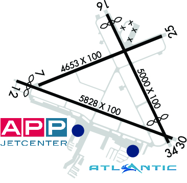
| WITHAM FIELD STUART FL |
| |
| Lat: N 2710.9 Long: W 08013.3 Elev: 16 Var: +06 Longest Runway: 5828 | ||
| Clr Del: 121.02 Dept. ATIS: 134.47 Arr. ATIS: 134.47 AWOS: 134.47 Ground: 121.7 Tower: 126.6 | ||
| ||||||||||||||||||||||||||||||||||||||||||||||||||||||||||||||||||||
| ||||||||||||||||||||||||||||||||||||||||||||||||||||||||||||||||||||
| ||||||||||||||||||||||||||||||||||||||||||||||||||||||||||||||||||||
| ||||||||||||||||||||||||||||||||||||||||||||||||||||||||||||||||||||
| ||||||||||||||||||||||||||||||||||||||||||||||||||||||||||||||||||||
| ||||||||||||||||||||||||||||||||||||||||||||||||||||||||||||||||||||
| Rwy | Rwy | |||||||
| 4653x100 | 4653' | 4653x100 | 4653' | |||||
| 5828x100 | 5368' | 5828x100 | 5828' | |||||
| 5000x100 | 4664' | 5000x100 | 4100' | |||||
| Runway ID | Single Wheel | Double Wheel | Double Tandem Wheel | Dual Double Wheel |
| 07/25 | 58,000 | 95,000 | 170,000 | N/A |
| 12/30 | 65,000 | 105,000 | 190,000 | N/A |
| 16/34 | 55,000 | 90,000 | 160,000 | N/A |
| These numbers are Advisory and are not limits. The Airport Manager should have more accurate Weight Limits | ||||
 Airport Diagram might not be current. | |
| Facility Name: | WITHAM FLD |
| City Name: | STUART |
| County: | MARTIN |
| State abbrev: | FL |
| State Name: | FLORIDA |
| Ownership: | PUBLICLY OWNED |
| Use: | OPEN TO THE PUBLIC |
| Owner's Name: | MARTIN COUNTY |
| Address: | 2401 SE MONTEREY RD |
| STUART, FL 34996 | |
| Owner's Phone: | 772-221-2374 |
| Manager's Name: | ANDREW MCBEAN |
| Address: | 2011 SOUTHEAST AIRPORT ROAD |
| STUART, FL 34996 | |
| Phone: | 772-221-1458 |
| FAA Region: | SOUTHERN |
| FAA Field Office: | ORL |
| Date | Sunrise | Sunset |
|---|---|---|
| 06/08/26 Monday | 6:26 | 20:14 |
| 06/09/26 Tuesday | 6:26 | 20:15 |
| 06/10/26 Wednesday | 6:26 | 20:15 |
| 06/11/26 Thursday | 6:26 | 20:15 |
| 06/12/26 Friday | 6:26 | 20:16 |
| 06/13/26 Saturday | 6:26 | 20:16 |
| 06/14/26 Sunday | 6:26 | 20:16 |
| 06/15/26 Monday | 6:26 | 20:17 |
| 06/16/26 Tuesday | 6:26 | 20:17 |
| 06/17/26 Wednesday | 6:26 | 20:17 |
| 06/18/26 Thursday | 6:26 | 20:18 |
| 06/19/26 Friday | 6:27 | 20:18 |
| 06/20/26 Saturday | 6:27 | 20:18 |
| 06/21/26 Sunday | 6:27 | 20:18 |
| Airport Attendance Schedule | 7 Days A Week 0600-2200 |
| Airport Status | OPERATIONAL (This Status can change at any time - please check NOTAMS) |
| Airport Lighting Schedule | AFTER 2200 ACTVT REIL RWY 12 & 30; MIRL RWY 07/25 & 12/30- CTAF. |
| Airport Storage Available | Tie Downs, Hanger |
| Extra Services Available | Air Ambulance, Avionics, Charter, Flight Instruction, Aircraft Rental, Aircraft Sales |
| Wind Indicator | YES - (lighted) |
| Control Tower | YES |
| CTAF Frequency | 126.600 |
| Unicom Frequency | |
| Rotating Beacon Color | WG |
| Segmented Circle | YES |
| Landing Fee | NO |
| Airport Inspected | STATE - performed by STATE AERONAUTICAL PERSONNEL |
| Inspection Date | 01/13/2026 |
| Type of Fuel Available | Grade 100LL, JET A (freeze point -40C) |
| Airframe Repair Service | MAJOR |
| Power Plant Repair Service | MAJOR |
| Latitude | N2710.9 |
| Longitude | W08013.3 (ESTIMATED) |
| Arpt Elevation | 16ft (SURVEYED) |
| Magnetic Variation | 06W |
| 1 miles SE | of STUART |
| Traffic Pattern Altitude | |
| Sectional Chart | MIAMI |
| Operations (Reported) | Yearly | Avg. Daily |
|---|---|---|
| General Aviation Transient | 0 | 0 |
| General Aviation Local | 0 | 0 |
| Air Taxi | 0 | 0 |
| Commerical | 0 | 0 |
| Commuter | 0 | 0 |
| Military | 0 | 0 |
| Aircraft based on Field | |
|---|---|
| General Aviation Singles | 0 |
| General Aviation Multi | 0 |
| Jet Aircraft | 0 |
| General Aviation Helicopters | 0 |
| Military Aircraft | 0 |
| Gliders | 0 |
| Ultralights | 0 |
| FSS on field | NO |
| FSS tie-in | MIAMI |
| FSS Phone | 1-800-WX-BRIEF |
| Who issues Notams | MIA |
| Notam D service at airport | YES |
| ARTCC Name | MIAMI |
| Airport Certification | |
| Aircraft Rescue & Firefighting Index | None |
| Airport of Entry | No |
| Custom Landing Rights | No; US CUSTOMS USER FEE ARPT. |
| Joint Civil/Military | No |
| Military Landing rights | YES |
| NATIONAL PLAN OF INTEGRATED AIRPORT SYSTEMS (NPIAS) |
| GRANT AGREEMENTS UNDER FAAP/ADAP/AIP |
| SURPLUS PROPERTY AGREEMENT UNDER REGULATION 16-WAA |
| ASSURANCES PURSUANT TO TITLE VI, CIVIL RIGHTS ACT OF 1964 |
| AGREEMENT UNDER DLAND OR DCLA HAS EXPIRED. |
| ACFT WITH WING SPANS EXCEEDING 79 FT ARE PROHIBITED FROM OPERATING ON TWY 'A' BETWEEN TWY 'C' AND APCH END RY 12 WHEN ACFT WITH WING SPAN EXCEEDING 79 FT IS ON APCH TO, LNDG, OR TAKING OFF RY 12/30. |
| BIRDS ON & INVOF ARPT. |
| PAPI RESTRICTED TO 7.5 NM WEST OF RWY 25 DUE TO 1548' MSL TOWERS WITHIN 10 DEG OF EXT CNTLN. |
| WHEN ATCT CLSD, FOR CD CTC PALM BEACH APCH AT 561-684-9047. |
| NOISE SENSITIVE AREAS ALL QUADRANTS. NOISE ABATEMENT PROCEDURES IN EFFECT CALL AMGR 772-221-2374. |
| TOUCH & GO OPNS PERMITTED MON-SAT (EXCP NEW YEARS, CHRISTMAS & THANKSGIVING) 0900 UNTIL 2 HRS PAST SS AND ARE LIMITED TO 3 OPNS PER PILOT PER DAY. |
| STOP & GO OPNS AND INTXN TKOFS STRONGLY DISCOURAGED AT ALL TIMES. |
| STAGE 1 & 2 JET OPNS STRONGLY DISCOURAGED 2300-0800. |
| PPR FOR ACFT EXCEEDING RY WT CPTY. |
| RWY 12/3 0 ARRESTING GEAR/SYSTEM: ENGINEERED MATERIALS ARRESTING SYSTEM (EMAS) 502 FT IN LENGTH BY 109 FT IN WIDTH AT THE DEPARTURE END OF RWY 12. ARRESTING GEAR/SYSTEM: ENGINEERED MATERIALS ARRESTING SYSTEM (EMAS) 413 FT IN LENGTH BY 109 FT IN WIDTH AT THE DEPARTURE END OF RWY 30. |
Airport Communications & Frequencies:
| |||||||||||||||||||||||
| Runway: 07 | Runway: 25 | ||
| Mag heading: | 74° | Mag heading: | 254° |
| Rwy Slope: | -.12% Down | Rwy Slope: | .12% Up |
| Approach: | Approach: | ||
| Pattern: | Left Traffic | Pattern: | Left Traffic |
| Markings: | NONPRECISION INSTRUMENT | Markings: | NONPRECISION INSTRUMENT |
| Marking Condition: | FAIR | Marking Condition: | FAIR |
| Arresting Dev: | Arresting Dev: | ||
| Lat & Long: | N2710.9 W08013.7 | Lat. & Long.: | N2711.2 W08012.9 |
| Elev: | 15.4 ft. MSL | Elev: | 9.9 ft. MSL |
| TCH: | 42 ft. AGL | TCH: | 44 ft. AGL |
| Visual Glide Path: | 3.00 degrees | Visual Glide Path: | 3.00 degrees |
| Displaced Threshold: | No | Displaced Threshold: | No |
| Touchdown Zone: | YES | Touchdown Zone: | YES |
| Touchdown Elev.: | 15.6 feet | Touchdown Elev.: | 14.8 feet |
| Visual Glide Slope: | 4-Light PAPI on LEFT side of Runway | Visual Glide Slope: | 4-Light PAPI on LEFT side of Runway |
| RVR Equipment: | RVR Equipment: | ||
| RVV Equipment: | NO | RVV Equipment: | NO |
| Approach Lights: | Approach Lights: | ||
| REIL: | NO | REIL: | NO |
| Centerline Lights: | NO | Centerline Lights: | NO |
| Touchdown lights: | NO | Touchdown lights: | NO |
| Runway Category: | Runway with a Visual Approach | Runway Category: | Runway with a Visual Approach |
| Declared Distances: | Declared Distances: | ||
| Obstructions: | TOWER | Obstructions: | TREE |
| Marked: | NOT Marked/Lighted | Marked: | NOT Marked/Lighted |
| Clearance slope: | 30:1 | Clearance slope: | 23:1 |
| Obstruction height: | 61 feet AGL | Obstruction height: | 49 feet AGL |
| Dist. from runway: | 2052 feet | Dist. from runway: | 1355 feet |
| Centerline offset: | 75 left of centerline | Centerline offset: | 290 feet left of centerline |
| Comments: | Comments: |
| Runway: 12 | Runway: 30 | ||
| Mag heading: | 116° | Mag heading: | 296° |
| Rwy Slope: | -.06% Down | Rwy Slope: | .06% Up |
| Approach: | Approach: | ||
| Pattern: | Left Traffic | Pattern: | Left Traffic |
| Markings: | NONPRECISION INSTRUMENT | Markings: | NONPRECISION INSTRUMENT |
| Marking Condition: | FAIR | Marking Condition: | FAIR |
| Arresting Dev: | EMAS | Arresting Dev: | EMAS |
| Lat & Long: | N2710.9 W08013.9 | Lat. & Long.: | N2710.6 W08012.9 |
| Elev: | 14.7 ft. MSL | Elev: | 11.4 ft. MSL |
| TCH: | 35 ft. AGL | TCH: | 28 ft. AGL |
| Visual Glide Path: | 3.00 degrees | Visual Glide Path: | 3.00 degrees |
| Displaced Threshold: | 460 feet | Displaced Threshold: | No |
| Touchdown Zone: | YES | Touchdown Zone: | YES |
| Touchdown Elev.: | 16.1 feet | Touchdown Elev.: | 16.1 feet |
| Visual Glide Slope: | 4-Light PAPI on LEFT side of Runway | Visual Glide Slope: | 4-Light PAPI on LEFT side of Runway |
| RVR Equipment: | RVR Equipment: | ||
| RVV Equipment: | NO | RVV Equipment: | NO |
| Approach Lights: | Approach Lights: | ||
| REIL: | YES | REIL: | YES |
| Centerline Lights: | NO | Centerline Lights: | NO |
| Touchdown lights: | NO | Touchdown lights: | NO |
| Runway Category: | Runway with a Non-precision Approach having visibility minimums greater than 3/4 mile | Runway Category: | Runway with a Non-precision Approach having visibility minimums greater than 3/4 mile |
| Declared Distances: | TORA:5828' TODA:5828' ASDA:5828' LDA:5368' | Declared Distances: | TORA:5828' TODA:5828' ASDA:5828' LDA:5828' |
| Obstructions: | TREES | Obstructions: | TREE |
| Marked: | NOT Marked/Lighted | Marked: | NOT Marked/Lighted |
| Clearance slope: | 14:1; RWY 12 APCH SLP 34:1 TO DSPLCD THLD. | Clearance slope: | 28:1; RWY 30 APCH SLP 34:1 TO AER. |
| Obstruction height: | 34 feet AGL | Obstruction height: | 28 feet AGL |
| Dist. from runway: | 690 feet | Dist. from runway: | 1000 feet |
| Centerline offset: | 260 left of centerline | Centerline offset: | 265 feet left of centerline |
| Comments: | Comments: |
| Runway: 16 | Runway: 34 | ||
| Mag heading: | 160° | Mag heading: | 340° |
| Rwy Slope: | .00% Down | Rwy Slope: | .00% Up |
| Approach: | Approach: | ||
| Pattern: | Left Traffic | Pattern: | Left Traffic |
| Markings: | BASIC | Markings: | BASIC |
| Marking Condition: | FAIR | Marking Condition: | FAIR |
| Arresting Dev: | Arresting Dev: | ||
| Lat & Long: | N2711.3 W08013.3 | Lat. & Long.: | N2710.6 W08012.9 |
| Elev: | 11.9 ft. MSL | Elev: | 11.7 ft. MSL |
| TCH: | TCH: | ||
| Visual Glide Path: | Visual Glide Path: | ||
| Displaced Threshold: | 336 feet | Displaced Threshold: | 900 feet |
| Touchdown Zone: | YES | Touchdown Zone: | YES |
| Touchdown Elev.: | 13.1 feet | Touchdown Elev.: | 13.1 feet |
| Visual Glide Slope: | Visual Glide Slope: | ||
| RVR Equipment: | RVR Equipment: | ||
| RVV Equipment: | NO | RVV Equipment: | NO |
| Approach Lights: | Approach Lights: | ||
| REIL: | NO | REIL: | NO |
| Centerline Lights: | NO | Centerline Lights: | NO |
| Touchdown lights: | NO | Touchdown lights: | NO |
| Runway Category: | Runway with a Visual Approach | Runway Category: | Runway with a Visual Approach |
| Declared Distances: | TORA:5000' TODA:5000' ASDA:4800' LDA:4464' | Declared Distances: | TORA:5000' TODA:5000' ASDA:5000' LDA:4100' |
| Obstructions: | TREES | Obstructions: | TREES |
| Marked: | NOT Marked/Lighted | Marked: | NOT Marked/Lighted |
| Clearance slope: | 17:1; RWY 16 APCH SLP 30:1 TO DSPLCD THLD. | Clearance slope: | 1:1; RWY 34 APCH RATIO 35:1 TO DSPLCD THLD. |
| Obstruction height: | 47 feet AGL | Obstruction height: | 22 feet AGL |
| Dist. from runway: | 1045 feet | Dist. from runway: | 200 feet |
| Centerline offset: | 245 left of centerline | Centerline offset: | 150 feet left of centerline |
| Comments: | Comments: | RWY 34 HAS 22 FT TREES AND 8 FT FENCE 200 FT FROM THE RWY END AND 150 FT LEFT. |
Thanks for using FltPlan.com
all rights reserved © 1999-2026 by Flight Plan LLC