
| CHARLES SCHULZ - SONOMA COUNTY SANTA ROSA CA |
| |
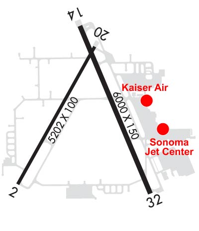
| Lat: N 3830.6 Long: W 12248.8 Elev: 129 Var: -16 Longest Runway: 6000 | ||
| Dept. ATIS: 120.55 Arr. ATIS: 120.55 Ground: 121.9 Tower: 118.5 | ||
| |||||||||||||||||||||||||||||||||||||||||||||||||||||||||||||||||||||
| |||||||||||||||||||||||||||||||||||||||||||||||||||||||||||||||||||||
| |||||||||||||||||||||||||||||||||||||||||||||||||||||||||||||||||||||
| |||||||||||||||||||||||||||||||||||||||||||||||||||||||||||||||||||||
| |||||||||||||||||||||||||||||||||||||||||||||||||||||||||||||||||||||
| Rwy | Rwy | |||||||
| 5202x100 | 5202' | 5202x100 | 5202' | |||||
| 6000x150 | 6000' | 6000x150 | 6000' | 109.30 - 321° | ||||
| Runway ID | Single Wheel | Double Wheel | Double Tandem Wheel | Dual Double Wheel |
| 02/20 | 109,000 | 154,000 | 254,000 | N/A |
| 14/32 | 120,000 | 184,000 | 300,000 | 697,000 |
| These numbers are Advisory and are not limits. The Airport Manager should have more accurate Weight Limits | ||||
 Airport Diagram might not be current. | |
| Facility Name: | CHARLES M SCHULZ/SONOMA COUNTY |
| City Name: | SANTA ROSA |
| County: | SONOMA |
| State abbrev: | CA |
| State Name: | CALIFORNIA |
| Ownership: | PUBLICLY OWNED |
| Use: | OPEN TO THE PUBLIC |
| Owner's Name: | SONOMA COUNTY |
| Address: | 2290 AIRPORT BLVD |
| SANTA ROSA, CA 95403 | |
| Owner's Phone: | 707-565-7243 |
| Manager's Name: | JON G. STOUT; SAMONAE CARTER, ASST ARPT MGR, PHONE 707- 565-7245. |
| Address: | 2290 AIRPORT BLVD |
| SANTA ROSA, CA 95403 | |
| Phone: | 707-565-7243 |
| FAA Region: | WESTERN-PACIFIC |
| FAA Field Office: | SFO |
| Date | Sunrise | Sunset |
|---|---|---|
| 06/08/26 Monday | 5:47 | 20:34 |
| 06/09/26 Tuesday | 5:47 | 20:34 |
| 06/10/26 Wednesday | 5:47 | 20:35 |
| 06/11/26 Thursday | 5:47 | 20:35 |
| 06/12/26 Friday | 5:46 | 20:36 |
| 06/13/26 Saturday | 5:46 | 20:36 |
| 06/14/26 Sunday | 5:46 | 20:37 |
| 06/15/26 Monday | 5:46 | 20:37 |
| 06/16/26 Tuesday | 5:47 | 20:37 |
| 06/17/26 Wednesday | 5:47 | 20:38 |
| 06/18/26 Thursday | 5:47 | 20:38 |
| 06/19/26 Friday | 5:47 | 20:38 |
| 06/20/26 Saturday | 5:47 | 20:39 |
| 06/21/26 Sunday | 5:47 | 20:39 |
| Airport Attendance Schedule | 7 Days A Week 0600-2200 |
| Airport Status | OPERATIONAL (This Status can change at any time - please check NOTAMS) |
| Airport Lighting Schedule | WHEN ATCT CLSD ACTVT REIL RWY 14; MALSR RWY 32; PAPI RWY 02, 20, & 14; HIRL RWY 14/32; MIRL RWY 02/20; TWY LGTS - CTAF. |
| Airport Storage Available | Tie Downs |
| Extra Services Available | Avionics, Cargo Handling, Charter, Flight Instruction, Aircraft Rental, Aircraft Sales |
| Wind Indicator | YES - (lighted) |
| Control Tower | YES |
| CTAF Frequency | 118.500 |
| Unicom Frequency | 122.950 |
| Rotating Beacon Color | WG |
| Segmented Circle | YES |
| Landing Fee | YES |
| Airport Inspected | FEDERAL - performed by FAA AIRPORTS FIELD PERSONNEL |
| Inspection Date | 01/15/2026 |
| Type of Fuel Available | Grade 100LL, JET A-1 (freeze point -50C); -10100LL AVBL 24 HRS WITH CREDIT CARD.; -A1JET A1 AVBL DURG ATTENDANCE HRS. |
| Airframe Repair Service | MAJOR |
| Power Plant Repair Service | MAJOR |
| Latitude | N3830.6 |
| Longitude | W12248.8 (ESTIMATED) |
| Arpt Elevation | 128ft (SURVEYED) |
| Magnetic Variation | 16E |
| 6 miles NW | of SANTA ROSA |
| Traffic Pattern Altitude | TPA FOR SMALL ACFT 1,000 FT AGL AND TPA FOR LARGE ACFT 1,500 FT AGL. |
| Sectional Chart | SAN FRANCISCO |
| Operations (Reported) | Yearly | Avg. Daily |
|---|---|---|
| General Aviation Transient | 0 | 0 |
| General Aviation Local | 0 | 0 |
| Air Taxi | 0 | 0 |
| Commerical | 0 | 0 |
| Commuter | 0 | 0 |
| Military | 0 | 0 |
| Aircraft based on Field | |
|---|---|
| General Aviation Singles | 0 |
| General Aviation Multi | 0 |
| Jet Aircraft | 0 |
| General Aviation Helicopters | 0 |
| Military Aircraft | 0 |
| Gliders | 0 |
| Ultralights | 0 |
| FSS on field | NO |
| FSS tie-in | OAKLAND |
| FSS Phone | 1-800-WX-BRIEF |
| Who issues Notams | STS |
| Notam D service at airport | YES |
| ARTCC Name | OAKLAND |
| Airport Certification | AIRPORT RECEIVING SCHEDULED AIR CARRIER SERVICE FROM CARRIERS CERTIFICATED BY THE CIVIL AERONAUTICS BOARD |
| Aircraft Rescue & Firefighting Index | AIRPORT HAS A CERTIFICATE UNDER CFR PART 139 |
| Airport of Entry | No |
| Custom Landing Rights | No |
| Joint Civil/Military | No |
| Military Landing rights | YES |
| NATIONAL PLAN OF INTEGRATED AIRPORT SYSTEMS (NPIAS) |
| GRANT AGREEMENTS UNDER FAAP/ADAP/AIP |
| SURPLUS PROPERTY AGREEMENT UNDER PUBLIC LAW 289 |
| SURPLUS PROPERTY AGREEMENT UNDER REGULATION 16-WAA |
| ASSURANCES PURSUANT TO TITLE VI, CIVIL RIGHTS ACT OF 1964 |
| FOR NOISE ABATEMENT PROCS PLEASE VISIT THE ARPT WEBSITE AT FLYSTS.COM |
| DEER ON AND INVOF ARPT. |
| WHEN ATCT CLSD, FOR CD CTC OAKLAND ARTCC AT 510-745-3380. |
| TWY Z BTN RWY 14/32 & TWY A LMTD TO S-20, D-40. |
| BE ALERT FOR NUMEROUS FLOCKS OF BIRDS ON AND INVOF AIRPORT, INCLUDING SEASONALLY MIGRATORY GEESE. |
| (LAHSO_ALD, RWY 02) CTC ATCT FOR AVBLTY. |
| RWY 02/2 0 PCR VALUE: 309/F/C/X/T |
| RWY 14/3 2 PCR VALUE: 454/F/C/X/T |
Airport Communications & Frequencies:
| |||||||||||||||||||
| Runway: 02 | Runway: 20 | ||
| Mag heading: | 13° | Mag heading: | 193° |
| Rwy Slope: | -.29% Down | Rwy Slope: | .29% Up |
| Approach: | Approach: | ||
| Pattern: | Left Traffic | Pattern: | Left Traffic |
| Markings: | NONPRECISION INSTRUMENT | Markings: | BASIC |
| Marking Condition: | GOOD | Marking Condition: | GOOD |
| Arresting Dev: | Arresting Dev: | ||
| Lat & Long: | N3830.2 W12249.3 | Lat. & Long.: | N3830.9 W12248.7 |
| Elev: | 128.5 ft. MSL | Elev: | 113.3 ft. MSL |
| TCH: | 50 ft. AGL | TCH: | 48 ft. AGL |
| Visual Glide Path: | 3.00 degrees | Visual Glide Path: | 3.50 degrees |
| Displaced Threshold: | No | Displaced Threshold: | No |
| Touchdown Zone: | YES | Touchdown Zone: | YES |
| Touchdown Elev.: | 128.7 feet | Touchdown Elev.: | 116.5 feet |
| Visual Glide Slope: | 2-Light PAPI on LEFT side of Runway; PAPI UNUSBL BYD 5 DEG LEFT OF CNTRLN | Visual Glide Slope: | 4-Light PAPI on LEFT side of Runway |
| RVR Equipment: | RVR Equipment: | ||
| RVV Equipment: | NO | RVV Equipment: | NO |
| Approach Lights: | Approach Lights: | ||
| REIL: | NO | REIL: | NO |
| Centerline Lights: | NO | Centerline Lights: | NO |
| Touchdown lights: | NO | Touchdown lights: | NO |
| Runway Category: | Runway with a Non-precision Approach having visibility minimums greater than 3/4 mile | Runway Category: | Runway with a Visual Approach |
| Declared Distances: | TORA:5202' TODA:5202' ASDA:4802' LDA:4802' | Declared Distances: | TORA:5202' TODA:5202' ASDA:5202' LDA:5202' |
| Obstructions: | TREES | Obstructions: | TREES |
| Marked: | NOT Marked/Lighted | Marked: | NOT Marked/Lighted |
| Clearance slope: | 20:1 | Clearance slope: | 30:1 |
| Obstruction height: | 131 feet AGL | Obstruction height: | 33 feet AGL |
| Dist. from runway: | 2900 feet | Dist. from runway: | 1200 feet |
| Centerline offset: | Centerline offset: | 200 feet right of centerline | |
| Comments: | Comments: |
| Runway: 14 | Runway: 32 | ||
| Mag heading: | 141° | Mag heading: | 321° |
| Rwy Slope: | .17% Up | Rwy Slope: | -.17% Down |
| Approach: | Approach: | ILS | |
| Pattern: | Right Traffic | Pattern: | Left Traffic |
| Markings: | PRECISION INSTRUMENT | Markings: | PRECISION INSTRUMENT |
| Marking Condition: | GOOD | Marking Condition: | GOOD |
| Arresting Dev: | Arresting Dev: | ||
| Lat & Long: | N3831.1 W12248.8 | Lat. & Long.: | N3830.1 W12248.3 |
| Elev: | 110.5 ft. MSL | Elev: | 120.4 ft. MSL |
| TCH: | 49 ft. AGL | TCH: | |
| Visual Glide Path: | 3.00 degrees | Visual Glide Path: | |
| Displaced Threshold: | No | Displaced Threshold: | No |
| Touchdown Zone: | YES | Touchdown Zone: | YES |
| Touchdown Elev.: | 119.6 feet | Touchdown Elev.: | 122.3 feet |
| Visual Glide Slope: | 4-Light PAPI on RIGHT side of Runway | Visual Glide Slope: | |
| RVR Equipment: | ROLLOUT | RVR Equipment: | TOUCHDOWN |
| RVV Equipment: | NO | RVV Equipment: | NO |
| Approach Lights: | Approach Lights: | MALSR - 1,400 foot medium intensity approach lighting system with runway alignment indicator lights | |
| REIL: | YES | REIL: | NO |
| Centerline Lights: | NO | Centerline Lights: | NO |
| Touchdown lights: | NO | Touchdown lights: | NO |
| Runway Category: | Runway with a Non-precision Approach having visibility minimums greater than 3/4 mile | Runway Category: | Precision Instrument Runway |
| Declared Distances: | TORA:6000' TODA:6000' ASDA:5880' LDA:5880' | Declared Distances: | TORA:6000' TODA:6000' ASDA:6000' LDA:6000' |
| Obstructions: | TREES | Obstructions: | TREES |
| Marked: | NOT Marked/Lighted | Marked: | NOT Marked/Lighted |
| Clearance slope: | 35:1 | Clearance slope: | 45:1 |
| Obstruction height: | 17 feet AGL | Obstruction height: | 135 feet AGL |
| Dist. from runway: | 800 feet | Dist. from runway: | 6400 feet |
| Centerline offset: | 250 left of centerline | Centerline offset: | |
| Comments: | Comments: |
Thanks for using FltPlan.com
all rights reserved © 1999-2026 by Flight Plan LLC