
| ST PAUL DOWNTOWN HOLMAN FLD ST PAUL MN |
| |
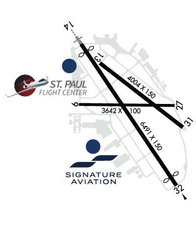
| Lat: N 4456.1 Long: W 09303.6 Elev: 705 Var: -00 Longest Runway: 6491 | ||
| Clr Del: 121.67 Dept. ATIS: 118.35 Arr. ATIS: 118.35 Ground: 121.67 Tower: 119.1 | ||

| ||||||||||||||||||||||||||||||||||||||||||||||||||||||||||||||||||||
| ||||||||||||||||||||||||||||||||||||||||||||||||||||||||||||||||||||
| ||||||||||||||||||||||||||||||||||||||||||||||||||||||||||||||||||||
| ||||||||||||||||||||||||||||||||||||||||||||||||||||||||||||||||||||
| Rwy | Rwy | |||||||
| 3642x100 | 3642' | 3642x100 | 3642' | |||||
| 4004x150 | 4004' | 4004x150 | 4004' | |||||
| 6491x150 | 6148' | 111.50 - 146° | 6491x150 | 6109' | 111.50 - 326° | |||
| Runway ID | Single Wheel | Double Wheel | Double Tandem Wheel | Dual Double Wheel |
| 09/27 | 12,500 | N/A | N/A | N/A |
| 13/31 | 97,000 | 135,000 | 228,000 | N/A |
| 14/32 | 83,000 | 111,000 | 197,000 | N/A |
| These numbers are Advisory and are not limits. The Airport Manager should have more accurate Weight Limits | ||||
 Airport Diagram might not be current. | |
| Facility Name: | ST PAUL DOWNTOWN HOLMAN FLD |
| City Name: | ST PAUL |
| County: | RAMSEY |
| State abbrev: | MN |
| State Name: | MINNESOTA |
| Ownership: | PUBLICLY OWNED |
| Use: | OPEN TO THE PUBLIC |
| Owner's Name: | METRO ARPT COMMSN |
| Address: | 6040 28TH AVE, SO |
| MINNEAPOLIS, MN 55450 | |
| Owner's Phone: | 651-726-8100 |
| Manager's Name: | BLAINE PETERSON; MAINT SUPVR, 612-919-5370 OR 612-919-5372, MON-FRI 0600-2200. |
| Address: | 644 BAYFIELD; EMAIL ADDRESS: BLAINE.PETERSON@MSPMAC.ORG |
| ST PAUL, MN 55107 | |
| Phone: | 651-224-4306; 651-224-4306 |
| FAA Region: | GREAT LAKES |
| FAA Field Office: | DMA |
| Date | Sunrise | Sunset |
|---|---|---|
| 06/08/26 Monday | 5:26 | 20:57 |
| 06/09/26 Tuesday | 5:26 | 20:57 |
| 06/10/26 Wednesday | 5:26 | 20:58 |
| 06/11/26 Thursday | 5:25 | 20:58 |
| 06/12/26 Friday | 5:25 | 20:59 |
| 06/13/26 Saturday | 5:25 | 20:59 |
| 06/14/26 Sunday | 5:25 | 21:00 |
| 06/15/26 Monday | 5:25 | 21:00 |
| 06/16/26 Tuesday | 5:25 | 21:01 |
| 06/17/26 Wednesday | 5:25 | 21:01 |
| 06/18/26 Thursday | 5:25 | 21:02 |
| 06/19/26 Friday | 5:25 | 21:02 |
| 06/20/26 Saturday | 5:25 | 21:02 |
| 06/21/26 Sunday | 5:26 | 21:02 |
| Airport Attendance Schedule | CONTINUOUS |
| Airport Status | OPERATIONAL (This Status can change at any time - please check NOTAMS) |
| Airport Lighting Schedule | WHEN ATCT CLSD, TO INCR INTST & ACTVT MALSR RWY 14; REIL RWY 31; PAPI RWY 13, 27, & 31; HIRL RWY 14/32 & 13/31; MIRL RWY 09/27; - CTAF. RWY 14 & 32 PAPI OPS CONSLY. |
| Airport Storage Available | Tie Downs, Hanger |
| Extra Services Available | Air Ambulance, Avionics, Charter, Flight Instruction, Aircraft Rental, Aircraft Sales |
| Wind Indicator | YES - (lighted) |
| Control Tower | YES |
| CTAF Frequency | 119.100 |
| Unicom Frequency | 122.950 |
| Rotating Beacon Color | WG; AIRPORT BEACON ON WEST EDGE OF ARPT. |
| Segmented Circle | NO |
| Landing Fee | YES |
| Airport Inspected | FEDERAL - performed by STATE AERONAUTICAL PERSONNEL |
| Inspection Date | 06/05/2025 |
| Type of Fuel Available | Grade 100LL, JET A (freeze point -40C); -A JET A LANDING FEE, CTC FBO. |
| Airframe Repair Service | MAJOR |
| Power Plant Repair Service | MAJOR |
| Latitude | N4456.1 |
| Longitude | W09303.6 (ESTIMATED) |
| Arpt Elevation | 705ft (ESTIMATED) |
| Magnetic Variation | 00E |
| 1 miles S | of ST PAUL |
| Traffic Pattern Altitude | 1200 |
| Sectional Chart | TWIN CITIES |
| Operations (Reported) | Yearly | Avg. Daily |
|---|---|---|
| General Aviation Transient | 0 | 0 |
| General Aviation Local | 0 | 0 |
| Air Taxi | 0 | 0 |
| Commerical | 0 | 0 |
| Commuter | 0 | 0 |
| Military | 0 | 0 |
| Aircraft based on Field | |
|---|---|
| General Aviation Singles | 0 |
| General Aviation Multi | 0 |
| Jet Aircraft | 0 |
| General Aviation Helicopters | 0 |
| Military Aircraft | 0 |
| Gliders | 0 |
| Ultralights | 0 |
| FSS on field | NO |
| FSS tie-in | PRINCETON |
| FSS Phone | 1-800-WX-BRIEF |
| Who issues Notams | STP |
| Notam D service at airport | YES |
| ARTCC Name | MINNEAPOLIS |
| Airport Certification | |
| Aircraft Rescue & Firefighting Index | None |
| Airport of Entry | No |
| Custom Landing Rights | YES; CUSTOMS 0800-1630 DLY - OTR HRS, ONE HR PPR THRU FSS. |
| Joint Civil/Military | No |
| Military Landing rights | YES |
| NATIONAL PLAN OF INTEGRATED AIRPORT SYSTEMS (NPIAS) |
| GRANT AGREEMENTS UNDER FAAP/ADAP/AIP |
| SURPLUS PROPERTY AGREEMENT UNDER PUBLIC LAW 289 |
| ASSURANCES PURSUANT TO TITLE VI, CIVIL RIGHTS ACT OF 1964 |
| BIRD ROOSTING & FEEDING AREAS ALONG RIVER BANKS. |
| VOLUNTARY NOISE ABATEMENT PROCS IN EFCT. SEE ARPT WEBSITE FOR MORE INFO. |
| TWY A CLSD BTN A3 AND A4 EXC FOR WINGSPAN LESS THAN 101FT. |
| TWY B CLSD BTN MN JET RAMP AND TWY A (SOUTHERN CORNER) EXC FOR WINGSPAN LESS THAN 72FT DUE TO FLOOD WALL OBSTACLE. |
| RWY 14 IS CALM WIND RWY WHEN ATCT CLSD. |
| EXPECT HELICOPTER OPERATIONS ON TWY 'A' IN THE VICINITY OF THE CONTROL TWR, NORTH TO THE APPROACH END OF RWY 14. |
| COLD TEMPERATURE AIRPORT. ALTITUDE CORRECTION REQUIRED AT OR BELOW -30C. |
| WHEN ATCT CLSD, FOR CD CTC MINNEAPOLIS APCH ON 121.675. |
| WHEN USING RWYS 27 OR 31 HAZARDOUS RIVER TFC MAY EXIST. |
| DEER, BIRDS & WILDLIFE ON & INVOF ARPT. |
| SE ARR & DEP AVOID TFC PATTERN OPS AT SOUTH ST. PAUL ARPT 164 DEG 5 NM AT & BLO 1720 MSL. |
| PPR ACFT OVER 100,000 LBS, CTC AMGR. |
| COMPLEX AIRPORT GEOMETRY. VERIFY CORRECT COMPASS HEADING PRIOR TO DEPARTURE. |
Airport Communications & Frequencies:
| |||||||||||||||||||||||||||||
| Runway: 09 | Runway: 27 | ||
| Mag heading: | 91° | Mag heading: | 271° |
| Rwy Slope: | .01% Up | Rwy Slope: | -.01% Down |
| Approach: | Approach: | ||
| Pattern: | Left Traffic | Pattern: | Right Traffic |
| Markings: | BASIC | Markings: | BASIC |
| Marking Condition: | GOOD | Marking Condition: | GOOD |
| Arresting Dev: | Arresting Dev: | ||
| Lat & Long: | N4456.1 W09304.1 | Lat. & Long.: | N4456.1 W09303.2 |
| Elev: | 700.4 ft. MSL | Elev: | 700.7 ft. MSL |
| TCH: | TCH: | 40 ft. AGL | |
| Visual Glide Path: | Visual Glide Path: | 4.00 degrees | |
| Displaced Threshold: | No | Displaced Threshold: | No |
| Touchdown Zone: | YES | Touchdown Zone: | YES |
| Touchdown Elev.: | 701.9 feet | Touchdown Elev.: | 701.9 feet |
| Visual Glide Slope: | Visual Glide Slope: | 4-Light PAPI on RIGHT side of Runway | |
| RVR Equipment: | RVR Equipment: | ||
| RVV Equipment: | NO | RVV Equipment: | NO |
| Approach Lights: | Approach Lights: | ||
| REIL: | NO | REIL: | NO |
| Centerline Lights: | NO | Centerline Lights: | NO |
| Touchdown lights: | NO | Touchdown lights: | NO |
| Runway Category: | Runway with a Visual Approach | Runway Category: | Runway with a Visual Approach |
| Declared Distances: | TORA:3642' TODA:3642' ASDA:3642' LDA:3642' | Declared Distances: | TORA:3642' TODA:3642' ASDA:3642' LDA:3642' |
| Obstructions: | TREE | Obstructions: | TREE |
| Marked: | NOT Marked/Lighted | Marked: | NOT Marked/Lighted |
| Clearance slope: | 14:1 | Clearance slope: | 7:1 |
| Obstruction height: | 33 feet AGL | Obstruction height: | 12 feet AGL |
| Dist. from runway: | 663 feet | Dist. from runway: | 284 feet |
| Centerline offset: | 160 right of centerline | Centerline offset: | 118 feet right of centerline |
| Comments: | Comments: |
| Runway: 13 | Runway: 31 | ||
| Mag heading: | 128° | Mag heading: | 308° |
| Rwy Slope: | -.09% Down | Rwy Slope: | .09% Up |
| Approach: | Approach: | ||
| Pattern: | Left Traffic | Pattern: | Left Traffic |
| Markings: | NONPRECISION INSTRUMENT | Markings: | NONPRECISION INSTRUMENT |
| Marking Condition: | GOOD | Marking Condition: | GOOD |
| Arresting Dev: | Arresting Dev: | ||
| Lat & Long: | N4456.4 W09303.9 | Lat. & Long.: | N4455.9 W09303.2 |
| Elev: | 704.5 ft. MSL | Elev: | 700.9 ft. MSL |
| TCH: | 40 ft. AGL | TCH: | 45 ft. AGL |
| Visual Glide Path: | 3.00 degrees | Visual Glide Path: | 3.00 degrees |
| Displaced Threshold: | No | Displaced Threshold: | No |
| Touchdown Zone: | YES | Touchdown Zone: | YES |
| Touchdown Elev.: | 704.6 feet | Touchdown Elev.: | 704.2 feet |
| Visual Glide Slope: | 4-Light PAPI on LEFT side of Runway; PAPI UNUSBL BYD 4 DEG RIGHT OF CNTRLN & UNUSBL INSIDE .5 NM. | Visual Glide Slope: | 4-Light PAPI on LEFT side of Runway |
| RVR Equipment: | RVR Equipment: | ||
| RVV Equipment: | NO | RVV Equipment: | NO |
| Approach Lights: | Approach Lights: | ||
| REIL: | NO | REIL: | YES |
| Centerline Lights: | NO | Centerline Lights: | NO |
| Touchdown lights: | NO | Touchdown lights: | NO |
| Runway Category: | Runway with a Visual Approach | Runway Category: | Runway with a Visual Approach |
| Declared Distances: | TORA:4004' TODA:4004' ASDA:4004' LDA:4004' | Declared Distances: | TORA:4004' TODA:4004' ASDA:4004' LDA:4004' |
| Obstructions: | Obstructions: | BRUSH | |
| Marked: | Marked: | NOT Marked/Lighted | |
| Clearance slope: | 20:1 | Clearance slope: | 12:1 |
| Obstruction height: | Obstruction height: | 9 feet AGL | |
| Dist. from runway: | Dist. from runway: | 311 feet | |
| Centerline offset: | Centerline offset: | 32 feet right of centerline | |
| Comments: | Comments: |
| Runway: 14 | Runway: 32 | ||
| Mag heading: | 146° | Mag heading: | 326° |
| Rwy Slope: | .01% Up | Rwy Slope: | -.01% Down |
| Approach: | ILS/DME | Approach: | ILS/DME |
| Pattern: | Left Traffic | Pattern: | Left Traffic |
| Markings: | PRECISION INSTRUMENT | Markings: | PRECISION INSTRUMENT |
| Marking Condition: | GOOD | Marking Condition: | GOOD |
| Arresting Dev: | EMAS; ENGINEERED MATERIALS ARRESTING SYSTEM (EMAS) 280 FT IN LENGTH BY 162 FT IN WIDTH LCTD AT THE DER 14. | Arresting Dev: | EMAS; ENGINEERED MATERIALS ARRESTING SYSTEM (EMAS) 225 FT IN LENGTH BY 162 FT IN WIDTH LCTD AT THE DER 32. |
| Lat & Long: | N4456.5 W09304.1 | Lat. & Long.: | N4455.6 W09303.2 |
| Elev: | 704.0 ft. MSL | Elev: | 704.4 ft. MSL |
| TCH: | 50 ft. AGL | TCH: | 40 ft. AGL |
| Visual Glide Path: | 3.00 degrees | Visual Glide Path: | 3.00 degrees |
| Displaced Threshold: | 343 feet | Displaced Threshold: | 382 feet |
| Touchdown Zone: | YES | Touchdown Zone: | YES |
| Touchdown Elev.: | 705.0 feet | Touchdown Elev.: | 703.6 feet |
| Visual Glide Slope: | 4-Light PAPI on RIGHT side of Runway; PAPI UNUSBL BYD 8 DEG LEFT OF CNTRLN. | Visual Glide Slope: | 4-Light PAPI on LEFT side of Runway |
| RVR Equipment: | TOUCHDOWN-ROLLOUT | RVR Equipment: | TOUCHDOWN-ROLLOUT |
| RVV Equipment: | NO | RVV Equipment: | NO |
| Approach Lights: | MALSR - 1,400 foot medium intensity approach lighting system with runway alignment indicator lights | Approach Lights: | |
| REIL: | NO | REIL: | YES |
| Centerline Lights: | NO | Centerline Lights: | NO |
| Touchdown lights: | NO | Touchdown lights: | NO |
| Runway Category: | Precision Instrument Runway | Runway Category: | Precision Instrument Runway |
| Declared Distances: | TORA:6491' TODA:6491' ASDA:6491' LDA:6148' | Declared Distances: | TORA:6491' TODA:6491' ASDA:6491' LDA:6109' |
| Obstructions: | ROAD | Obstructions: | TREES |
| Marked: | NOT Marked/Lighted | Marked: | NOT Marked/Lighted |
| Clearance slope: | 32:1; RY 14 APCH RATIO 45:1 TO DISPL THSD FOR ROAD +13, 179 FM END, 494R. | Clearance slope: | 25:1; RY 32 APCH RATIO 34:1 TO DSPLCD THR. |
| Obstruction height: | 12 feet AGL | Obstruction height: | 60 feet AGL |
| Dist. from runway: | 586 feet | Dist. from runway: | 1728 feet |
| Centerline offset: | Centerline offset: | 100 feet right of centerline | |
| Comments: | RY 14: ROAD +13 179 FM END, 494R. | Comments: | +8' TREE 95' FM RY END 380'R OF CNTRLN. |
Thanks for using FltPlan.com
all rights reserved © 1999-2026 by Flight Plan LLC


