
| STEVENS POINT MUNI STEVENS POINT WI |
| |
| Lat: N 4432.7 Long: W 08931.8 Elev: 1110 Var: +01 Longest Runway: 6028 | ||
| AWOS: 119.27 CTAF: 122.7 | ||
| ||||||
| ||||||
|
| Rwy | Rwy | |||||||
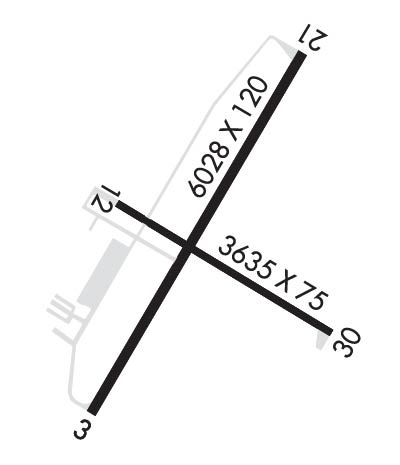
| 6028x120 | 6028' | 6028x120 | 6028' | 111.35 - 210° | ||||
| 3635x75 | 3635' | 3635x75 | 3635' | |||||
| Runway ID | Single Wheel | Double Wheel | Double Tandem Wheel | Dual Double Wheel |
| 03/21 | 30,000 | 75,000 | 195,000 | N/A |
| 12/30 | 9,000 | 75,000 | N/A | N/A |
| These numbers are Advisory and are not limits. The Airport Manager should have more accurate Weight Limits | ||||
 Airport Diagram might not be current. | |
| Facility Name: | STEVENS POINT MUNI |
| City Name: | STEVENS POINT |
| County: | PORTAGE |
| State abbrev: | WI |
| State Name: | WISCONSIN |
| Ownership: | PUBLICLY OWNED |
| Use: | OPEN TO THE PUBLIC |
| Owner's Name: | STEVENS POINT |
| Address: | 1515 STRONGS AVE |
| STEVENS POINT, WI 54481 | |
| Owner's Phone: | 715-345-8989 |
| Manager's Name: | JASON DRAHEIM |
| Address: | 4501 HWY 66; EMAIL ADDRESS: JDRAHEIM@STEVENSPOINT.COM (ALL LOWER CASE) |
| STEVENS POINT, WI 54482 | |
| Phone: | 715-345-8993; AFT HRS CALL 715-345-8989; OPTION 3. |
| FAA Region: | GREAT LAKES |
| FAA Field Office: | CHI |
| Date | Sunrise | Sunset |
|---|---|---|
| 06/08/26 Monday | 5:14 | 20:41 |
| 06/09/26 Tuesday | 5:13 | 20:42 |
| 06/10/26 Wednesday | 5:13 | 20:42 |
| 06/11/26 Thursday | 5:13 | 20:43 |
| 06/12/26 Friday | 5:13 | 20:43 |
| 06/13/26 Saturday | 5:13 | 20:44 |
| 06/14/26 Sunday | 5:13 | 20:44 |
| 06/15/26 Monday | 5:12 | 20:45 |
| 06/16/26 Tuesday | 5:12 | 20:45 |
| 06/17/26 Wednesday | 5:13 | 20:46 |
| 06/18/26 Thursday | 5:13 | 20:46 |
| 06/19/26 Friday | 5:13 | 20:46 |
| 06/20/26 Saturday | 5:13 | 20:46 |
| 06/21/26 Sunday | 5:13 | 20:47 |
| Airport Attendance Schedule | MON-FRI 0730-1630, SAT-SUN ON CALL |
| Airport Status | OPERATIONAL (This Status can change at any time - please check NOTAMS) |
| Airport Lighting Schedule | HIRL ON ACTV RWY PRESET TO LOW SS-SR; TO INCR INTST AND ACTVT MALS RWY 21; REIL RWY 03; PAPI RWY 03 & 21; HIRL RWY 03/21 & RWY 12/30 - CTAF. |
| Airport Storage Available | Tie Downs, Hanger |
| Extra Services Available | NONE |
| Wind Indicator | YES - (lighted) |
| Control Tower | NO |
| CTAF Frequency | 122.700 |
| Unicom Frequency | 122.700 |
| Rotating Beacon Color | WG |
| Segmented Circle | YES |
| Landing Fee | NO |
| Airport Inspected | STATE - performed by STATE AERONAUTICAL PERSONNEL |
| Inspection Date | 08/02/2023 |
| Type of Fuel Available | Grade 100LL, JET A; -1024 HR SELF SVC FUEL AVBL WITH CREDIT CARD. |
| Airframe Repair Service | NONE |
| Power Plant Repair Service | NONE |
| Latitude | N4432.7 |
| Longitude | W08931.8 (ESTIMATED) |
| Arpt Elevation | 1110ft (SURVEYED) |
| Magnetic Variation | 01W |
| 3 miles NE | of STEVENS POINT |
| Traffic Pattern Altitude | |
| Sectional Chart | GREEN BAY |
| Operations (Reported) | Yearly | Avg. Daily |
|---|---|---|
| General Aviation Transient | 0 | 0 |
| General Aviation Local | 0 | 0 |
| Air Taxi | 0 | 0 |
| Commerical | 0 | 0 |
| Commuter | 0 | 0 |
| Military | 0 | 0 |
| Aircraft based on Field | |
|---|---|
| General Aviation Singles | 0 |
| General Aviation Multi | 0 |
| Jet Aircraft | 0 |
| General Aviation Helicopters | 0 |
| Military Aircraft | 0 |
| Gliders | 0 |
| Ultralights | 0 |
| FSS on field | NO |
| FSS tie-in | GREEN BAY |
| FSS Phone | 1-800-WX-BRIEF |
| Who issues Notams | STE |
| Notam D service at airport | YES |
| ARTCC Name | MINNEAPOLIS |
| Airport Certification | |
| Aircraft Rescue & Firefighting Index | None |
| Airport of Entry | No |
| Custom Landing Rights | No |
| Joint Civil/Military | No |
| Military Landing rights | YES |
| NATIONAL PLAN OF INTEGRATED AIRPORT SYSTEMS (NPIAS) |
| GRANT AGREEMENTS UNDER FAAP/ADAP/AIP |
| ASSURANCES PURSUANT TO TITLE VI, CIVIL RIGHTS ACT OF 1964 |
| THIS AIRPORT HAS BEEN SURVEYED BY THE NATIONAL GEODETIC SURVEY. |
| MIGRATORY WATERFOWL ON & INVOF ARPT. |
| FOR CD CTC MINNEAPOLIS ARTCC AT 651-463-5588. |
Airport Communications & Frequencies:
| |||||||||
| Runway: 03 | Runway: 21 | ||
| Mag heading: | 31° | Mag heading: | 211° |
| Rwy Slope: | .10% Up | Rwy Slope: | -.10% Down |
| Approach: | Approach: | ILS/DME | |
| Pattern: | Left Traffic | Pattern: | Left Traffic |
| Markings: | NONPRECISION INSTRUMENT | Markings: | NONPRECISION INSTRUMENT |
| Marking Condition: | GOOD | Marking Condition: | GOOD |
| Arresting Dev: | Arresting Dev: | ||
| Lat & Long: | N4432.3 W08932.2 | Lat. & Long.: | N4433.2 W08931.5 |
| Elev: | 1104.0 ft. MSL | Elev: | 1110.0 ft. MSL |
| TCH: | 44 ft. AGL | TCH: | 45 ft. AGL |
| Visual Glide Path: | 3.00 degrees | Visual Glide Path: | 3.00 degrees |
| Displaced Threshold: | No | Displaced Threshold: | No |
| Touchdown Zone: | YES | Touchdown Zone: | YES |
| Touchdown Elev.: | 1108.1 feet | Touchdown Elev.: | 1110.0 feet |
| Visual Glide Slope: | 2-Light PAPI on LEFT side of Runway | Visual Glide Slope: | 4-Light PAPI on LEFT side of Runway |
| RVR Equipment: | RVR Equipment: | ||
| RVV Equipment: | NO | RVV Equipment: | NO |
| Approach Lights: | Approach Lights: | MALS - 1,400 foot medium intensity approach lighting system | |
| REIL: | YES | REIL: | NO |
| Centerline Lights: | NO | Centerline Lights: | NO |
| Touchdown lights: | NO | Touchdown lights: | NO |
| Runway Category: | Runway with a Non-precision Approach having visibility minimums greater than 3/4 mile | Runway Category: | Precision Instrument Runway |
| Declared Distances: | Declared Distances: | ||
| Obstructions: | TREES | Obstructions: | TREES |
| Marked: | NOT Marked/Lighted | Marked: | NOT Marked/Lighted |
| Clearance slope: | 23:1 | Clearance slope: | 4:1 |
| Obstruction height: | 40 feet AGL | Obstruction height: | 16 feet AGL |
| Dist. from runway: | 1140 feet | Dist. from runway: | 265 feet |
| Centerline offset: | 600 left of centerline | Centerline offset: | 510 feet right of centerline |
| Comments: | Comments: |
| Runway: 12 | Runway: 30 | ||
| Mag heading: | 121° | Mag heading: | 301° |
| Rwy Slope: | -.06% Down | Rwy Slope: | .06% Up |
| Approach: | Approach: | ||
| Pattern: | Left Traffic | Pattern: | Left Traffic |
| Markings: | NONPRECISION INSTRUMENT | Markings: | NONPRECISION INSTRUMENT |
| Marking Condition: | GOOD | Marking Condition: | GOOD |
| Arresting Dev: | Arresting Dev: | ||
| Lat & Long: | N4432.8 W08932.1 | Lat. & Long.: | N4432.5 W08931.4 |
| Elev: | 1105.0 ft. MSL | Elev: | 1103.0 ft. MSL |
| TCH: | TCH: | ||
| Visual Glide Path: | Visual Glide Path: | ||
| Displaced Threshold: | No | Displaced Threshold: | No |
| Touchdown Zone: | YES | Touchdown Zone: | YES |
| Touchdown Elev.: | 1108.1 feet | Touchdown Elev.: | 1108.1 feet |
| Visual Glide Slope: | Visual Glide Slope: | ||
| RVR Equipment: | RVR Equipment: | ||
| RVV Equipment: | NO | RVV Equipment: | NO |
| Approach Lights: | Approach Lights: | ||
| REIL: | NO | REIL: | NO |
| Centerline Lights: | NO | Centerline Lights: | NO |
| Touchdown lights: | NO | Touchdown lights: | NO |
| Runway Category: | Runway with a Non-precision Approach | Runway Category: | Runway with a Non-precision Approach |
| Declared Distances: | Declared Distances: | ||
| Obstructions: | TREES | Obstructions: | TREES |
| Marked: | NOT Marked/Lighted | Marked: | NOT Marked/Lighted |
| Clearance slope: | 9:1 | Clearance slope: | 9:1 |
| Obstruction height: | 56 feet AGL | Obstruction height: | 15 feet AGL |
| Dist. from runway: | 745 feet | Dist. from runway: | 340 feet |
| Centerline offset: | 320 right of centerline | Centerline offset: | 205 feet left of centerline |
| Comments: | Comments: |
Thanks for using FltPlan.com
all rights reserved © 1999-2026 by Flight Plan LLC
