
| ST CLOUD RGNL ST CLOUD MN |
| |
| Lat: N 4532.8 Long: W 09403.6 Elev: 1031 Var: -03 Longest Runway: 7500 | ||
| Dept. ATIS: 119.37 Arr. ATIS: 119.37 AWOS: 112.1 Ground: 123.75 Tower: 118.25 | ||
| ||||||||||||||||||||||||||||||||||||||||||||
| ||||||||||||||||||||||||||||||||||||||||||||
| ||||||||||||||||||||||||||||||||||||||||||||
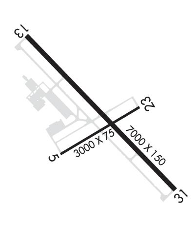
| Rwy | Rwy | |||||||
| 3000x75 | 3000' | 3000x75 | 3000' | |||||
| 7500x150 | 7500' | 111.90 - 132° | 7500x150 | 7000' | 111.90 - 313° | |||
| Runway ID | Single Wheel | Double Wheel | Double Tandem Wheel | Dual Double Wheel |
| 05/23 | 50,000 | 75,000 | N/A | N/A |
| 13/31 | 75,000 | 175,000 | 280,000 | N/A |
| These numbers are Advisory and are not limits. The Airport Manager should have more accurate Weight Limits | ||||
 Airport Diagram might not be current. | |
| Facility Name: | ST CLOUD SKY CENTRAL |
| City Name: | ST CLOUD |
| County: | SHERBURNE |
| State abbrev: | MN |
| State Name: | MINNESOTA |
| Ownership: | PUBLICLY OWNED |
| Use: | OPEN TO THE PUBLIC |
| Owner's Name: | ST CLOUD RGNL ARPT AUTH |
| Address: | 1550 45TH AVE SE STE 1 |
| SAINT CLOUD, MN 56304-9634 | |
| Owner's Phone: | 320-255-7292 |
| Manager's Name: | BILL P TOWLE; WILLIAM.TOWLE@CI.STCLOUD.MN.US. |
| Address: | 1550 45TH AVE SE STE 1 |
| SAINT CLOUD, MN 56304-9634 | |
| Phone: | 320-255-7292 |
| FAA Region: | GREAT LAKES |
| FAA Field Office: | DMA |
| Date | Sunrise | Sunset |
|---|---|---|
| 06/08/26 Monday | 5:28 | 21:03 |
| 06/09/26 Tuesday | 5:27 | 21:04 |
| 06/10/26 Wednesday | 5:27 | 21:04 |
| 06/11/26 Thursday | 5:27 | 21:05 |
| 06/12/26 Friday | 5:27 | 21:05 |
| 06/13/26 Saturday | 5:27 | 21:06 |
| 06/14/26 Sunday | 5:27 | 21:06 |
| 06/15/26 Monday | 5:27 | 21:07 |
| 06/16/26 Tuesday | 5:27 | 21:07 |
| 06/17/26 Wednesday | 5:27 | 21:08 |
| 06/18/26 Thursday | 5:27 | 21:08 |
| 06/19/26 Friday | 5:27 | 21:08 |
| 06/20/26 Saturday | 5:27 | 21:09 |
| 06/21/26 Sunday | 5:27 | 21:09 |
| Airport Attendance Schedule | 7 Days A Week 0500-2330 |
| Airport Status | OPERATIONAL (This Status can change at any time - please check NOTAMS) |
| Airport Lighting Schedule | ACTVT MALSR RWY 13 & 31 - CTAF. PAPI 13 & 31; HIRL RWY 13/31; MIRL RWY 05/23 PRESET ON LOW INTST, TO INCR INTST & ACTVT - CTAF. |
| Airport Storage Available | Tie Downs, Hanger |
| Extra Services Available | Avionics, Flight Instruction, Aircraft Rental, Aircraft Sales |
| Wind Indicator | YES - (lighted) |
| Control Tower | YES |
| CTAF Frequency | 118.250 |
| Unicom Frequency | |
| Rotating Beacon Color | WG |
| Segmented Circle | YES |
| Landing Fee | NO |
| Airport Inspected | FEDERAL - performed by FAA AIRPORTS FIELD PERSONNEL |
| Inspection Date | 07/22/2025 |
| Type of Fuel Available | Grade 100LL, JET A (freeze point -40C) |
| Airframe Repair Service | MAJOR |
| Power Plant Repair Service | MAJOR |
| Latitude | N4532.8 |
| Longitude | W09403.6 (ESTIMATED) |
| Arpt Elevation | 1030ft (ESTIMATED) |
| Magnetic Variation | 03E |
| 4 miles E | of ST CLOUD |
| Traffic Pattern Altitude | |
| Sectional Chart | TWIN CITIES |
| Operations (Reported) | Yearly | Avg. Daily |
|---|---|---|
| General Aviation Transient | 0 | 0 |
| General Aviation Local | 0 | 0 |
| Air Taxi | 0 | 0 |
| Commerical | 0 | 0 |
| Commuter | 0 | 0 |
| Military | 0 | 0 |
| Aircraft based on Field | |
|---|---|
| General Aviation Singles | 0 |
| General Aviation Multi | 0 |
| Jet Aircraft | 0 |
| General Aviation Helicopters | 0 |
| Military Aircraft | 0 |
| Gliders | 0 |
| Ultralights | 0 |
| FSS on field | NO |
| FSS tie-in | PRINCETON |
| FSS Phone | 1-800-WX-BRIEF |
| Who issues Notams | STC |
| Notam D service at airport | YES |
| ARTCC Name | MINNEAPOLIS |
| Airport Certification | AIRPORT RECEIVING SCHEDULED AIR CARRIER SERVICE FROM CARRIERS CERTIFICATED BY THE CIVIL AERONAUTICS BOARD; 24 HRS PPR FOR UNSKED ACR OPNS WITH MORE THAN 30 PSGR SEATS CALL AMGR 320-255-7292. |
| Aircraft Rescue & Firefighting Index | AIRPORT HAS A CERTIFICATE UNDER CFR PART 139 |
| Airport of Entry | No |
| Custom Landing Rights | No |
| Joint Civil/Military | No |
| Military Landing rights | YES |
| NATIONAL PLAN OF INTEGRATED AIRPORT SYSTEMS (NPIAS) |
| GRANT AGREEMENTS UNDER FAAP/ADAP/AIP |
| ASSURANCES PURSUANT TO TITLE VI, CIVIL RIGHTS ACT OF 1964 |
| RY 31 CALM WIND RY. |
| DEER, MIGRATORY WATERFOWL, AND OTHER WILDLIFE ON & INVOF ARPT. |
| FLIGHT TRAINING ON & INVOF ARPT. |
| CROP DUSTING OPERATIONS ON AND IN VICINITY OF AIRPORT DURING SUMMER MONTHS. |
| HELIPAD NOT VISIBLE FROM ATCT AND APPROACH SURFACES. |
| LINE OF SIGHT VISIBILITY IS RESTRICTED FROM THE 13 & 23 APPROACH AND RUNWAY 13 & 5 APPROACH |
| FOR CD WHEN ATCT IS CLSD CTC FSS VIA RCO, IF UNA CTC MINNEAPOLIS ARTCC AT 651-463-5588. |
| RWY 05/2 3 RWY 05/23 NOT AVBL FOR PART 121/PART 380 OPS WITH SKED PAX CARRYING OPS MORE THAN 9 PAX SEATS AND NON-SKED PAX CARRYING OPS MORE THAN 30 PAX SEATS. |
| RWY 13/3 1 RWY 13/31 200 FT BLAST PAD EACH END. |
| RWY 05/2 3 PCR VALUE: 28/F/A/X/T |
| RWY 13/3 1 PCR VALUE: 380/R/A/W/T |
Airport Communications & Frequencies:
| |||||||||||||
| Runway: 05 | Runway: 23 | ||
| Mag heading: | 56° | Mag heading: | 236° |
| Rwy Slope: | .03% Up | Rwy Slope: | -.03% Down |
| Approach: | Approach: | ||
| Pattern: | Left Traffic | Pattern: | Left Traffic |
| Markings: | BASIC | Markings: | BASIC |
| Marking Condition: | GOOD | Marking Condition: | GOOD |
| Arresting Dev: | Arresting Dev: | ||
| Lat & Long: | N4532.6 W09403.9 | Lat. & Long.: | N4532.9 W09403.3 |
| Elev: | 1021.1 ft. MSL | Elev: | 1022.0 ft. MSL |
| TCH: | 31 ft. AGL | TCH: | 30 ft. AGL |
| Visual Glide Path: | 3.00 degrees | Visual Glide Path: | 3.00 degrees |
| Displaced Threshold: | No | Displaced Threshold: | No |
| Touchdown Zone: | YES | Touchdown Zone: | YES |
| Touchdown Elev.: | 1022.0 feet | Touchdown Elev.: | 1022.0 feet |
| Visual Glide Slope: | 4-Light PAPI on RIGHT side of Runway | Visual Glide Slope: | 4-Light PAPI on LEFT side of Runway |
| RVR Equipment: | RVR Equipment: | ||
| RVV Equipment: | NO | RVV Equipment: | NO |
| Approach Lights: | Approach Lights: | ||
| REIL: | NO | REIL: | NO |
| Centerline Lights: | NO | Centerline Lights: | NO |
| Touchdown lights: | NO | Touchdown lights: | NO |
| Runway Category: | Runway with a Non-precision Approach having visibility minimums greater than 3/4 mile | Runway Category: | Runway with a Non-precision Approach having visibility minimums greater than 3/4 mile |
| Declared Distances: | TORA:3000' TODA:3000' ASDA:3000' LDA:3000' | Declared Distances: | TORA:3000' TODA:3000' ASDA:3000' LDA:3000' |
| Runway: 13 | Runway: 31 | ||
| Mag heading: | 133° | Mag heading: | 313° |
| Rwy Slope: | -.19% Down | Rwy Slope: | .19% Up |
| Approach: | ILS | Approach: | ILS |
| Pattern: | Left Traffic | Pattern: | Left Traffic |
| Markings: | PRECISION INSTRUMENT | Markings: | PRECISION INSTRUMENT |
| Marking Condition: | FAIR | Marking Condition: | FAIR |
| Arresting Dev: | Arresting Dev: | ||
| Lat & Long: | N4533.2 W09404.2 | Lat. & Long.: | N4532.3 W09402.9 |
| Elev: | 1030.5 ft. MSL | Elev: | 1015.9 ft. MSL |
| TCH: | 50 ft. AGL | TCH: | 50 ft. AGL |
| Visual Glide Path: | 3.00 degrees | Visual Glide Path: | 3.00 degrees |
| Displaced Threshold: | No | Displaced Threshold: | 500 feet |
| Touchdown Zone: | YES | Touchdown Zone: | YES |
| Touchdown Elev.: | 1030.5 feet | Touchdown Elev.: | 1020.4 feet |
| Visual Glide Slope: | 4-Light PAPI on RIGHT side of Runway | Visual Glide Slope: | 4-Light PAPI on LEFT side of Runway |
| RVR Equipment: | RVR Equipment: | ||
| RVV Equipment: | NO | RVV Equipment: | NO |
| Approach Lights: | MALSR - 1,400 foot medium intensity approach lighting system with runway alignment indicator lights | Approach Lights: | MALSR - 1,400 foot medium intensity approach lighting system with runway alignment indicator lights |
| REIL: | NO | REIL: | NO |
| Centerline Lights: | NO | Centerline Lights: | NO |
| Touchdown lights: | NO | Touchdown lights: | NO |
| Runway Category: | Precision Instrument Runway | Runway Category: | Precision Instrument Runway |
| Declared Distances: | TORA:7500' TODA:7500' ASDA:7000' LDA:7000' | Declared Distances: | TORA:7500' TODA:7500' ASDA:7500' LDA:7000' |
Thanks for using FltPlan.com
all rights reserved © 1999-2026 by Flight Plan LLC