
| ST SIMONS ISLAND ST SIMONS ISLAND GA |
| |
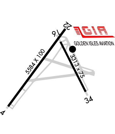
| Lat: N 3109.1 Long: W 08123.5 Elev: 19 Var: +05 Longest Runway: 5584 | ||
| AWOS: 120.02 CTAF: 123.05 | ||
| |||||||||||||||||||||||||||||||||||||||||||||||||||||||||||||||||||||
| |||||||||||||||||||||||||||||||||||||||||||||||||||||||||||||||||||||
| |||||||||||||||||||||||||||||||||||||||||||||||||||||||||||||||||||||
| Rwy | Rwy | |||||||
| 5584x100 | 4802' | 5584x100 | 4673' | |||||
| 3313x75 | 3313' | 3313x75 | 3313' | |||||
| Runway ID | Single Wheel | Double Wheel | Double Tandem Wheel | Dual Double Wheel |
| 04/22 | 45,000 | 60,000 | N/A | N/A |
| 16/34 | 14,000 | 30,000 | N/A | N/A |
| These numbers are Advisory and are not limits. The Airport Manager should have more accurate Weight Limits | ||||
 Airport Diagram might not be current. | |
| Facility Name: | ST SIMONS ISLAND |
| City Name: | ST SIMONS ISLAND |
| County: | GLYNN |
| State abbrev: | GA |
| State Name: | GEORGIA |
| Ownership: | PUBLICLY OWNED |
| Use: | OPEN TO THE PUBLIC |
| Owner's Name: | GLYNN COUNTY - GLYNN CO. ARPT COMM. |
| Address: | 295 AVIATION PARKWAY, SUITE 205 |
| BRUNSWICK, GA 31525 | |
| Owner's Phone: | (912) 265-2070 |
| Manager's Name: | ROBERT BURR |
| Address: | 295 AVIATION PARKWAY, SUITE 205 |
| BRUNSWICK, GA 31525 | |
| Phone: | 912-265-2070 |
| FAA Region: | SOUTHERN |
| FAA Field Office: | ATL |
| Date | Sunrise | Sunset |
|---|---|---|
| 06/08/26 Monday | 6:21 | 20:28 |
| 06/09/26 Tuesday | 6:21 | 20:29 |
| 06/10/26 Wednesday | 6:21 | 20:29 |
| 06/11/26 Thursday | 6:21 | 20:29 |
| 06/12/26 Friday | 6:21 | 20:30 |
| 06/13/26 Saturday | 6:21 | 20:30 |
| 06/14/26 Sunday | 6:21 | 20:31 |
| 06/15/26 Monday | 6:21 | 20:31 |
| 06/16/26 Tuesday | 6:21 | 20:31 |
| 06/17/26 Wednesday | 6:21 | 20:32 |
| 06/18/26 Thursday | 6:22 | 20:32 |
| 06/19/26 Friday | 6:22 | 20:32 |
| 06/20/26 Saturday | 6:22 | 20:32 |
| 06/21/26 Sunday | 6:22 | 20:33 |
| Airport Attendance Schedule | 7 Days A Week 0700-2000 |
| Airport Status | OPERATIONAL (This Status can change at any time - please check NOTAMS) |
| Airport Lighting Schedule | ACTVT REIL RWY 04; HIRL RWY 04/22 & 16/34 - CTAF. |
| Airport Storage Available | Tie Downs, Hanger |
| Extra Services Available | Charter, Flight Instruction, Aircraft Rental, Aircraft Sales |
| Wind Indicator | YES - (lighted) |
| Control Tower | NO |
| CTAF Frequency | 123.050 |
| Unicom Frequency | 123.050 |
| Rotating Beacon Color | WG |
| Segmented Circle | YES |
| Landing Fee | NO |
| Airport Inspected | STATE - performed by STATE AERONAUTICAL PERSONNEL |
| Inspection Date | 04/08/2025 |
| Type of Fuel Available | Grade 100LL, JET A (freeze point -40C), JET A |
| Airframe Repair Service | MAJOR |
| Power Plant Repair Service | MINOR |
| Latitude | N3109.1 |
| Longitude | W08123.5 (ESTIMATED) |
| Arpt Elevation | 18ft (SURVEYED) |
| Magnetic Variation | 05W |
| 1 miles N | of ST SIMONS ISLAND |
| Traffic Pattern Altitude | |
| Sectional Chart | JACKSONVILLE |
| Operations (Reported) | Yearly | Avg. Daily |
|---|---|---|
| General Aviation Transient | 0 | 0 |
| General Aviation Local | 0 | 0 |
| Air Taxi | 0 | 0 |
| Commerical | 0 | 0 |
| Commuter | 0 | 0 |
| Military | 0 | 0 |
| Aircraft based on Field | |
|---|---|
| General Aviation Singles | 0 |
| General Aviation Multi | 0 |
| Jet Aircraft | 0 |
| General Aviation Helicopters | 0 |
| Military Aircraft | 0 |
| Gliders | 0 |
| Ultralights | 0 |
| FSS on field | NO |
| FSS tie-in | MACON |
| FSS Phone | 1-800-WX-BRIEF |
| Who issues Notams | SSI |
| Notam D service at airport | YES |
| ARTCC Name | JACKSONVILLE |
| Airport Certification | |
| Aircraft Rescue & Firefighting Index | None |
| Airport of Entry | No |
| Custom Landing Rights | YES |
| Joint Civil/Military | No |
| Military Landing rights | YES |
| NATIONAL PLAN OF INTEGRATED AIRPORT SYSTEMS (NPIAS) |
| GRANT AGREEMENTS UNDER FAAP/ADAP/AIP |
| SURPLUS PROPERTY AGREEMENT UNDER PUBLIC LAW 289 |
| ASSURANCES PURSUANT TO TITLE VI, CIVIL RIGHTS ACT OF 1964 |
| AGREEMENT UNDER DLAND OR DCLA HAS EXPIRED. |
| BIRDS AND WILDLIFE ON & INVOF ARPT. |
| PREF NOISE-ABATEMENT ARRIVAL FOR HEL TFC IS A STRAIGHT-IN TO RWY 34 THEN A MID-FIELD TURN TO LDG. ALL WHEELED HEL GND TAXI TO FINAL PRKG. |
| ADDITIONAL APT SAFETY BULLETINS POSTED AT WWW.FLYGCAIRPORTS.COM/SAFETY. |
| FOR CD CTC JACKSONVILLE ARTCC AT 904-845-1592. |
| FBO SVCS AVBL ON 130.65. |
| TRG FLTS ARE ENCOURAGED TO USE BRUNSWICK GOLDEN ISLES ARPT LCTD 7 NM NW OF ST. SIMONS ISLAND ARPT FOR OPS. |
| USE CTN DUE TO CONGESTED ASP WITH TURBINE, NONTURBINE, AND TRNG ACFT. BQK LOCATED 7NM NW. JEKYLL ISLAND AP 09J LOCATED 4NM S USING SAME CTAF FREQ 123.05. |
| RWY 22 PREF FOR LIGHT AND VRB WINDS OR CROSSWINDS. |
| ALL VFR ACFT ADHERE TO STD LH TFC PAT. |
| ACFT DEPARTING RWY 34 USE EXTRM CTN- APCH END OF RWY 04 NOT VSB FROM APCH END OF RWY 34. |
| ALL ARRIVALS AND DEPARTURES, INCLUDING ACFT FLYING INST APPROACHES, ARE REQSTD TO RPRT 10 MILES FROM THE AP, INTNS AND PSN REPORTS TO -ST SIMONS- CTAF 123.05. |
| PPR FOR SVC AND FUEL AFTER HRS CALL 912-638-8617. |
| ADJ RESIDENTIAL AREA TO THE SE AND SSW OF RWY 16/34 EXTREMELY NOISE SENSITIVE. |
Airport Communications & Frequencies:
| |||||||||
| Runway: 04 | Runway: 22 | ||
| Mag heading: | 41° | Mag heading: | 221° |
| Rwy Slope: | .10% Up | Rwy Slope: | -.10% Down |
| Approach: | Approach: | ||
| Pattern: | Left Traffic | Pattern: | Left Traffic |
| Markings: | NONPRECISION INSTRUMENT | Markings: | NONPRECISION INSTRUMENT |
| Marking Condition: | GOOD | Marking Condition: | GOOD |
| Arresting Dev: | Arresting Dev: | ||
| Lat & Long: | N3108.7 W08123.9 | Lat. & Long.: | N3109.5 W08123.3 |
| Elev: | 10.3 ft. MSL | Elev: | 16.1 ft. MSL |
| TCH: | 57 ft. AGL | TCH: | 54 ft. AGL |
| Visual Glide Path: | 4.00 degrees | Visual Glide Path: | 4.00 degrees |
| Displaced Threshold: | 782 feet | Displaced Threshold: | 911 feet |
| Touchdown Zone: | YES | Touchdown Zone: | YES |
| Touchdown Elev.: | 16.0 feet | Touchdown Elev.: | 17.4 feet |
| Visual Glide Slope: | 2-Light PAPI on LEFT side of Runway | Visual Glide Slope: | 2-Light PAPI on LEFT side of Runway |
| RVR Equipment: | RVR Equipment: | ||
| RVV Equipment: | NO | RVV Equipment: | NO |
| Approach Lights: | Approach Lights: | ||
| REIL: | YES | REIL: | NO |
| Centerline Lights: | NO | Centerline Lights: | NO |
| Touchdown lights: | NO | Touchdown lights: | NO |
| Runway Category: | Runway with a Non-precision Approach having visibility minimums greater than 3/4 mile | Runway Category: | Runway with a Non-precision Approach having visibility minimums greater than 3/4 mile |
| Declared Distances: | TORA:5580' TODA:5580' ASDA:5580' LDA:4798' | Declared Distances: | TORA:5580' TODA:5580' ASDA:5580' LDA:4671' |
| Obstructions: | ROAD | Obstructions: | BLDG |
| Marked: | NOT Marked/Lighted | Marked: | NOT Marked/Lighted |
| Clearance slope: | APCH RATIO 25:1 TO DSPLCD THR; 26 FT TREES 650 FT OUT AND 300 FT RIGHT. | Clearance slope: | 1:1; APCH RATIO 50:1 TO DSPLCD THR. |
| Obstruction height: | 15 feet AGL | Obstruction height: | 21 feet AGL |
| Dist. from runway: | 215 feet | Dist. from runway: | 232 feet |
| Centerline offset: | 256 left of centerline | Centerline offset: | 251 feet right of centerline |
| Comments: | +6 FT FENCE, +32 FT POWER POLE, +12 FT BUSH 75-200 FT FROM END OF RWY 228-250 FT LEFT. | Comments: | 6 FT FENCE 190 FT RIGHT OF CNTRLN, 140 FT FROM E.O.R. |
| Runway: 16 | Runway: 34 | ||
| Mag heading: | 159° | Mag heading: | 339° |
| Rwy Slope: | -.18% Down | Rwy Slope: | .18% Up |
| Approach: | Approach: | ||
| Pattern: | Left Traffic | Pattern: | Left Traffic |
| Markings: | BASIC | Markings: | BASIC |
| Marking Condition: | GOOD | Marking Condition: | GOOD |
| Arresting Dev: | Arresting Dev: | ||
| Lat & Long: | N3109.4 W08123.3 | Lat. & Long.: | N3108.9 W08123.1 |
| Elev: | 18.0 ft. MSL | Elev: | 11.9 ft. MSL |
| TCH: | 46 ft. AGL | TCH: | 55 ft. AGL |
| Visual Glide Path: | 3.25 degrees | Visual Glide Path: | 3.75 degrees |
| Displaced Threshold: | No | Displaced Threshold: | No |
| Touchdown Zone: | YES | Touchdown Zone: | YES |
| Touchdown Elev.: | 18.9 feet | Touchdown Elev.: | 18.9 feet |
| Visual Glide Slope: | 2-Light PAPI on LEFT side of Runway | Visual Glide Slope: | 2-Light PAPI on LEFT side of Runway |
| RVR Equipment: | RVR Equipment: | ||
| RVV Equipment: | NO | RVV Equipment: | NO |
| Approach Lights: | Approach Lights: | ||
| REIL: | NO | REIL: | NO |
| Centerline Lights: | NO | Centerline Lights: | NO |
| Touchdown lights: | NO | Touchdown lights: | NO |
| Runway Category: | Runway with a Visual Approach | Runway Category: | Runway with a Visual Approach |
| Declared Distances: | Declared Distances: | ||
| Obstructions: | TREES | Obstructions: | TREES |
| Marked: | NOT Marked/Lighted | Marked: | NOT Marked/Lighted |
| Clearance slope: | 18:1 | Clearance slope: | 13:1 |
| Obstruction height: | 30 feet AGL | Obstruction height: | 47 feet AGL |
| Dist. from runway: | 740 feet | Dist. from runway: | 845 feet |
| Centerline offset: | 150 right of centerline | Centerline offset: | 150 feet left of centerline |
| Comments: | Comments: |
Thanks for using FltPlan.com
all rights reserved © 1999-2026 by Flight Plan LLC