
| STINSON MUNI SAN ANTONIO TX |
| |
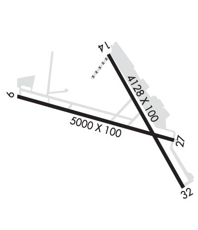
| Lat: N 2920.2 Long: W 09828.3 Elev: 578 Var: -08 Longest Runway: 5000 | ||
| Clr Del: 121.7 Dept. ATIS: 128.8 Arr. ATIS: 128.8 Ground: 121.7 Tower: 118.2 | ||
| ||||||||||||||||||||||||||||||||||||||||||||
| ||||||||||||||||||||||||||||||||||||||||||||
| ||||||||||||||||||||||||||||||||||||||||||||
| Rwy | Rwy | |||||||
| 5000x100 | 4550' | 5000x100 | 5000' | |||||
| 4128x100 | 3545' | 4128x100 | 3756' | |||||
| Runway ID | Single Wheel | Double Wheel | Double Tandem Wheel | Dual Double Wheel |
| 09/27 | 30,000 | 75,000 | N/A | N/A |
| 14/32 | 12,000 | 20,000 | N/A | N/A |
| These numbers are Advisory and are not limits. The Airport Manager should have more accurate Weight Limits | ||||
 Airport Diagram might not be current. | |
| Facility Name: | STINSON MUNI |
| City Name: | SAN ANTONIO |
| County: | BEXAR |
| State abbrev: | TX |
| State Name: | TEXAS |
| Ownership: | PUBLICLY OWNED |
| Use: | OPEN TO THE PUBLIC |
| Owner's Name: | CITY OF SAN ANTONIO |
| Address: | 8535 MISSION RD |
| SAN ANTONIO, TX 78214 | |
| Owner's Phone: | 210-207-1800 |
| Manager's Name: | MORRIS MARTIN |
| Address: | 8535 MISSION RD |
| SAN ANTONIO, TX 78214 | |
| Phone: | 210-207-1800; FAX: 210-207-1806 |
| FAA Region: | SOUTHWEST |
| FAA Field Office: | TEX |

| Date | Sunrise | Sunset |
|---|---|---|
| 09/24/21 Friday | 7:23 | 19:28 |
| 09/25/21 Saturday | 7:24 | 19:27 |
| 09/26/21 Sunday | 7:24 | 19:26 |
| 09/27/21 Monday | 7:25 | 19:25 |
| 09/28/21 Tuesday | 7:25 | 19:23 |
| 09/29/21 Wednesday | 7:26 | 19:22 |
| 09/30/21 Thursday | 7:26 | 19:21 |
| 10/01/21 Friday | 7:27 | 19:20 |
| 10/02/21 Saturday | 7:28 | 19:19 |
| 10/03/21 Sunday | 7:28 | 19:17 |
| 10/04/21 Monday | 7:29 | 19:16 |
| 10/05/21 Tuesday | 7:29 | 19:15 |
| 10/06/21 Wednesday | 7:30 | 19:14 |
| 10/07/21 Thursday | 7:30 | 19:13 |
| Airport Attendance Schedule | 7 Days A Week 0700-2200 |
| Airport Status | OPERATIONAL (This Status can change at any time - please check NOTAMS) |
| Airport Lighting Schedule | DUSK-DAWN. MIRL RWY 09/27 & 14/32 PRESET MED INTST WHEN ATCT CLSD. |
| Airport Storage Available | Tie Downs, Hanger |
| Extra Services Available | Charter, Flight Instruction, Aircraft Rental, Aircraft Sales |
| Wind Indicator | YES - (lighted) |
| Control Tower | YES |
| CTAF Frequency | 118.200 |
| Unicom Frequency | 122.950 |
| Rotating Beacon Color | CLEAR-GREEN (Light Land Airport) |
| Segmented Circle | NO |
| Landing Fee | NO |
| Airport Inspected | STATE - performed by STATE AERONAUTICAL PERSONNEL |
| Inspection Date | 05/10/2017 |
| Type of Fuel Available | Grade 100LL, JET A (freeze point -40C) |
| Airframe Repair Service | MAJOR |
| Power Plant Repair Service | MAJOR |
| Latitude | N2920.2 |
| Longitude | W09828.3 (ESTIMATED) |
| Arpt Elevation | 577ft (SURVEYED) |
| Magnetic Variation | 08E |
| 6 miles S | of SAN ANTONIO |
| Traffic Pattern Altitude | |
| Sectional Chart | SAN ANTONIO |
| Operations (Reported) | Yearly | Avg. Daily |
|---|---|---|
| General Aviation Transient | 26046 | 71 |
| General Aviation Local | 59455 | 163 |
| Air Taxi | 3278 | 9 |
| Commerical | 0 | 0 |
| Commuter | 0 | 0 |
| Military | 4378 | 12 |
| Aircraft based on Field | |
|---|---|
| General Aviation Singles | 65 |
| General Aviation Multi | 4 |
| Jet Aircraft | 0 |
| General Aviation Helicopters | 5 |
| Military Aircraft | 0 |
| Gliders | 0 |
| Ultralights | 0 |
| FSS on field | NO |
| FSS tie-in | SAN ANGELO |
| FSS Phone | 1-800-WX-BRIEF |
| Who issues Notams | SSF |
| Notam D service at airport | YES |
| ARTCC Name | HOUSTON |
| Airport Certification | |
| Aircraft Rescue & Firefighting Index | None |
| Airport of Entry | No |
| Custom Landing Rights | No |
| Joint Civil/Military | No |
| Military Landing rights | YES |
| NATIONAL PLAN OF INTEGRATED AIRPORT SYSTEMS (NPIAS) |
| GRANT AGREEMENTS UNDER FAAP/ADAP/AIP |
| SURPLUS PROPERTY AGREEMENT UNDER PUBLIC LAW 289 |
| ASSURANCES PURSUANT TO TITLE VI, CIVIL RIGHTS ACT OF 1964 |
| NUMEROUS ACFT OPERATING AT OR ABOVE 2500 FT MSL IN THE STINSON ARPT TFC AREA UNDER THE CTL OF SAN ANTONIO APCH. |
| PAEW ADJ ALL TWYS & RAMP AREAS MON-FRI 0700-1759. |
| FOR CD WHEN ATCT IS CLSD CTC SAT APCH AT 210-805-5516. |
Airport Communications & Frequencies:
| ||||||||||||||||||||||||||||||
| Runway: 09 | Runway: 27 | ||
| Mag heading: | 95° | Mag heading: | 275° |
| Rwy Slope: | -.25% Down | Rwy Slope: | .25% Up |
| Approach: | Approach: | ||
| Pattern: | Left Traffic | Pattern: | Left Traffic |
| Markings: | NONPRECISION INSTRUMENT | Markings: | NONPRECISION INSTRUMENT |
| Marking Condition: | GOOD | Marking Condition: | GOOD |
| Arresting Dev: | Arresting Dev: | ||
| Lat & Long: | N2920.3 W09828.9 | Lat. & Long.: | N2920.1 W09827.9 |
| Elev: | 577.6 ft. MSL | Elev: | 565.1 ft. MSL |
| TCH: | 40 ft. AGL | TCH: | 40 ft. AGL |
| Visual Glide Path: | 3.00 degrees | Visual Glide Path: | 3.00 degrees |
| Displaced Threshold: | 450 feet | Displaced Threshold: | No |
| Touchdown Zone: | YES | Touchdown Zone: | YES |
| Touchdown Elev.: | 576.9 feet | Touchdown Elev.: | 570.4 feet |
| Visual Glide Slope: | 4-Light PAPI on LEFT side of Runway | Visual Glide Slope: | 4-Light PAPI on LEFT side of Runway |
| RVR Equipment: | RVR Equipment: | ||
| RVV Equipment: | NO | RVV Equipment: | NO |
| Approach Lights: | Approach Lights: | ||
| REIL: | YES | REIL: | YES |
| Centerline Lights: | NO | Centerline Lights: | NO |
| Touchdown lights: | NO | Touchdown lights: | NO |
| Runway Category: | Runway with a Visual Approach | Runway Category: | Runway with a Visual Approach |
| Declared Distances: | Declared Distances: | ||
| Obstructions: | PLINE | Obstructions: | TREE |
| Marked: | LIGHTED | Marked: | NOT Marked/Lighted |
| Clearance slope: | 14:1; APCH SLOPE 36:1 TO DSPLCD THR TO 30 FT PLINE AT 1094 FT FM DSPLCD THR ACRS EXTENDED CNTRLN. | Clearance slope: | 31:1 |
| Obstruction height: | 30 feet AGL | Obstruction height: | 24 feet AGL |
| Dist. from runway: | 644 feet | Dist. from runway: | 959 feet |
| Centerline offset: | Centerline offset: | 203 feet right of centerline | |
| Comments: | +7 FT FENCE AT 25 FT; ROAD AT 75 FT ACROSS APCH. | Comments: |
| Runway: 14 | Runway: 32 | ||
| Mag heading: | 137° | Mag heading: | 317° |
| Rwy Slope: | -.46% Down | Rwy Slope: | .46% Up |
| Approach: | Approach: | ||
| Pattern: | Left Traffic | Pattern: | Left Traffic |
| Markings: | NONPRECISION INSTRUMENT | Markings: | NONPRECISION INSTRUMENT |
| Marking Condition: | GOOD | Marking Condition: | GOOD |
| Arresting Dev: | Arresting Dev: | ||
| Lat & Long: | N2920.5 W09828.3 | Lat. & Long.: | N2919.9 W09827.9 |
| Elev: | 572.0 ft. MSL | Elev: | 552.9 ft. MSL |
| TCH: | 35 ft. AGL | TCH: | 40 ft. AGL |
| Visual Glide Path: | 3.00 degrees | Visual Glide Path: | 3.00 degrees |
| Displaced Threshold: | 583 feet | Displaced Threshold: | 372 feet |
| Touchdown Zone: | YES | Touchdown Zone: | YES |
| Touchdown Elev.: | 571.3 feet | Touchdown Elev.: | 570.7 feet |
| Visual Glide Slope: | 2-Light PAPI on RIGHT side of Runway | Visual Glide Slope: | 4-Light PAPI on LEFT side of Runway |
| RVR Equipment: | RVR Equipment: | ||
| RVV Equipment: | NO | RVV Equipment: | NO |
| Approach Lights: | Approach Lights: | ||
| REIL: | YES | REIL: | YES |
| Centerline Lights: | NO | Centerline Lights: | NO |
| Touchdown lights: | NO | Touchdown lights: | NO |
| Runway Category: | Runway with a Visual Approach | Runway Category: | Runway with a Non-precision Approach |
| Declared Distances: | Declared Distances: | ||
| Obstructions: | TREES | Obstructions: | TREES |
| Marked: | NOT Marked/Lighted | Marked: | NOT Marked/Lighted |
| Clearance slope: | 2:1; APCH SLOPE 26:1 TO DSPLCD THR, +32 FT TREE AT 863 FT FM DSPLCD THR ACRS EXTENDED CNTRLN. | Clearance slope: | APCH SLOPE 22:1 TO DSPLCD THR, +50 FT TREE AT 1140 FT FM DSPLCD THR ON CNTRLN. |
| Obstruction height: | 32 feet AGL | Obstruction height: | 19 feet AGL |
| Dist. from runway: | 279 feet | Dist. from runway: | 200 feet |
| Centerline offset: | Centerline offset: | ||
| Comments: | +7 FT FENCE AT 21 FT, ROAD AT 52 FT ACROSS APCH; 24 FT TREE 195 FT FM THR AT 56 FT LEFT. | Comments: | +5 FT FENCE 75 FT FM THR; ROAD AT THR 100 FT LEFT; +25 FT TREES 0 FT FM THR 200 FT LEFT, 19 FT TREES 153-200 FT FM THR ON CNTRLN. |
Thanks for using FltPlan.com
all rights reserved © 1999-2021 by Flight Plan LLC