
| SIERRA BLANCA RGNL RUIDOSO NM |
| |
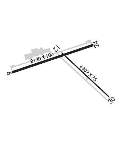
| Lat: N 3327.7 Long: W 10531.8 Elev: 6814 Var: -10 Longest Runway: 8120 | ||
| AWOS: 126.47 CTAF: 122.8 | ||
| ||||||
| ||||||
|
| Rwy | Rwy | |||||||
| 8120x100 | 8120' | 8120x100 | 8120' | 110.70 - 241° | ||||
| 6309x75 | 6309' | 6309x75 | 6309' | |||||
| Runway ID | Single Wheel | Double Wheel | Double Tandem Wheel | Dual Double Wheel |
| 06/24 | 85,000 | 125,000 | N/A | N/A |
| 12/30 | 12,500 | N/A | N/A | N/A |
| These numbers are Advisory and are not limits. The Airport Manager should have more accurate Weight Limits | ||||
 Airport Diagram might not be current. | |
| Facility Name: | SIERRA BLANCA RGNL |
| City Name: | RUIDOSO |
| County: | LINCOLN |
| State abbrev: | NM |
| State Name: | NEW MEXICO |
| Ownership: | PUBLICLY OWNED |
| Use: | OPEN TO THE PUBLIC |
| Owner's Name: | VILLAGE OF RUIDOSO |
| Address: | 313 CREE MEADOWS DR |
| RUIDOSO, NM 88345 | |
| Owner's Phone: | (575) 336-8111 |
| Manager's Name: | JOE KASUBOSKI (INTERIM MGR) |
| Address: | 313 CREE MEADOWS DR |
| RUIDOSO, NM 88345 | |
| Phone: | 575-336-8111 |
| FAA Region: | SOUTHWEST |
| FAA Field Office: | LNM |
| Date | Sunrise | Sunset |
|---|---|---|
| 09/24/21 Friday | 6:51 | 18:56 |
| 09/25/21 Saturday | 6:52 | 18:55 |
| 09/26/21 Sunday | 6:53 | 18:54 |
| 09/27/21 Monday | 6:53 | 18:52 |
| 09/28/21 Tuesday | 6:54 | 18:51 |
| 09/29/21 Wednesday | 6:55 | 18:49 |
| 09/30/21 Thursday | 6:56 | 18:48 |
| 10/01/21 Friday | 6:56 | 18:47 |
| 10/02/21 Saturday | 6:57 | 18:45 |
| 10/03/21 Sunday | 6:58 | 18:44 |
| 10/04/21 Monday | 6:58 | 18:43 |
| 10/05/21 Tuesday | 6:59 | 18:41 |
| 10/06/21 Wednesday | 7:00 | 18:40 |
| 10/07/21 Thursday | 7:01 | 18:39 |
| Airport Attendance Schedule | MAY - OCT 7 Days A Week 0700-1900, NOV - APR 7 Days A Week 0700-1800 |
| Airport Status | OPERATIONAL (This Status can change at any time - please check NOTAMS) |
| Airport Lighting Schedule | DUSK-DAWN. ACTVT MIRL RYS 06/24 & 12/30 - CTAF. |
| Airport Storage Available | Tie Downs, Hanger |
| Extra Services Available | Air Freight, Air Ambulance, Flight Instruction |
| Wind Indicator | YES - (lighted) |
| Control Tower | NO |
| CTAF Frequency | 122.800 |
| Unicom Frequency | 122.800 |
| Rotating Beacon Color | CLEAR-GREEN (Light Land Airport) |
| Segmented Circle | YES |
| Landing Fee |
| Airport Inspected | FEDERAL - performed by FAA AIRPORTS FIELD PERSONNEL |
| Inspection Date | 02/20/2020 |
| Type of Fuel Available | Grade 100LL, JET A (freeze point -40C); -10FOR FUEL AFTER HOURS CALL 575-973-0074. |
| Airframe Repair Service | None |
| Power Plant Repair Service | MAJOR |
| Latitude | N3327.7 |
| Longitude | W10531.8 (ESTIMATED) |
| Arpt Elevation | 6813ft (SURVEYED) |
| Magnetic Variation | 10E |
| 15 miles NE | of RUIDOSO |
| Traffic Pattern Altitude | |
| Sectional Chart | ALBUQUERQUE |
| Operations (Reported) | Yearly | Avg. Daily |
|---|---|---|
| General Aviation Transient | 7865 | 22 |
| General Aviation Local | 1920 | 5 |
| Air Taxi | 1004 | 3 |
| Commerical | 125 | 0 |
| Commuter | 0 | 0 |
| Military | 3364 | 9 |
| Aircraft based on Field | |
|---|---|
| General Aviation Singles | 9 |
| General Aviation Multi | 1 |
| Jet Aircraft | 2 |
| General Aviation Helicopters | 0 |
| Military Aircraft | 0 |
| Gliders | 0 |
| Ultralights | 0 |
| FSS on field | NO |
| FSS tie-in | ALBUQUERQUE |
| FSS Phone | 1-800-WX-BRIEF |
| Who issues Notams | SRR |
| Notam D service at airport | YES |
| ARTCC Name | ALBUQUERQUE |
| Airport Certification | CLSD TO ACR USING ACFT WITH MORE THAN 30 PSGR SEATS EXCP 24 HOURS PPR; CTC AMGR 575-336-8111. |
| Aircraft Rescue & Firefighting Index | AIRPORT HAS A CERTIFICATE UNDER CFR PART 139 |
| Airport of Entry | No |
| Custom Landing Rights | No |
| Joint Civil/Military | No |
| Military Landing rights | No |
| NATIONAL PLAN OF INTEGRATED AIRPORT SYSTEMS (NPIAS) |
| GRANT AGREEMENTS UNDER FAAP/ADAP/AIP |
| CONVEYANCE UNDER SCETION 16, FEDERAL AIRPORT ACT OF 1946 OR SECTION 23, AIRPORT AND AIRWAY DEVELOPMENT ACT OF 1970 |
| ASSURANCES PURSUANT TO TITLE VI, CIVIL RIGHTS ACT OF 1964 |
| RY 12/30 NOT AVBL FOR ACR OPNS WITH MORE THAN 30 PSGR SEATS. |
| AIRPORT SURFACE CONDITIONS ARE NOT MONITORED OUTSIDE OF ATTENDED HOURS. |
| FOR CD IF UNA TO CTC ON FSS FREQ, CTC ALBUQUERQUE ARTCC AT 505-856-4561. |
Airport Communications & Frequencies:
| |||||||||
| Runway: 06 | Runway: 24 | ||
| Mag heading: | 61° | Mag heading: | 241° |
| Rwy Slope: | -.77% Down | Rwy Slope: | .77% Up |
| Approach: | Approach: | ILS/DME | |
| Pattern: | Left Traffic | Pattern: | Left Traffic |
| Markings: | NONPRECISION INSTRUMENT | Markings: | PRECISION INSTRUMENT |
| Marking Condition: | GOOD | Marking Condition: | GOOD |
| Arresting Dev: | Arresting Dev: | ||
| Lat & Long: | N3327.6 W10532.8 | Lat. & Long.: | N3328.0 W10531.3 |
| Elev: | 6813.5 ft. MSL | Elev: | 6751.0 ft. MSL |
| TCH: | 32 ft. AGL | TCH: | 38 ft. AGL |
| Visual Glide Path: | 3.00 degrees | Visual Glide Path: | 3.00 degrees |
| Displaced Threshold: | No | Displaced Threshold: | No |
| Touchdown Zone: | YES | Touchdown Zone: | YES |
| Touchdown Elev.: | 6813.8 feet | Touchdown Elev.: | 6770.9 feet |
| Visual Glide Slope: | 2-Box VASI on LEFT side of Runway | Visual Glide Slope: | PULSATING/STEADY BURNING VASI ON LEFT SIDE OF RUNWAY |
| RVR Equipment: | RVR Equipment: | ||
| RVV Equipment: | NO | RVV Equipment: | NO |
| Approach Lights: | Approach Lights: | ||
| REIL: | NO | REIL: | NO |
| Centerline Lights: | NO | Centerline Lights: | NO |
| Touchdown lights: | NO | Touchdown lights: | NO |
| Runway Category: | Runway with a Visual Approach | Runway Category: | Precision Instrument Runway |
| Declared Distances: | TORA:8120' TODA:8120' ASDA:8120' LDA:8120' | Declared Distances: | TORA:8120' TODA:8120' ASDA:8120' LDA:8120' |
| Runway: 12 | Runway: 30 | ||
| Mag heading: | 122° | Mag heading: | 302° |
| Rwy Slope: | -.81% Down | Rwy Slope: | .81% Up |
| Approach: | Approach: | ||
| Pattern: | Left Traffic | Pattern: | Left Traffic |
| Markings: | BASIC | Markings: | NONPRECISION INSTRUMENT |
| Marking Condition: | GOOD | Marking Condition: | GOOD |
| Arresting Dev: | Arresting Dev: | ||
| Lat & Long: | N3327.9 W10531.9 | Lat. & Long.: | N3327.2 W10531.0 |
| Elev: | 6772.7 ft. MSL | Elev: | 6721.4 ft. MSL |
| TCH: | TCH: | ||
| Visual Glide Path: | Visual Glide Path: | ||
| Displaced Threshold: | No | Displaced Threshold: | No |
| Touchdown Zone: | YES | Touchdown Zone: | YES |
| Touchdown Elev.: | 6772.7 feet | Touchdown Elev.: | 6748.5 feet |
| Visual Glide Slope: | Visual Glide Slope: | ||
| RVR Equipment: | RVR Equipment: | ||
| RVV Equipment: | NO | RVV Equipment: | NO |
| Approach Lights: | Approach Lights: | ||
| REIL: | NO | REIL: | NO |
| Centerline Lights: | NO | Centerline Lights: | NO |
| Touchdown lights: | NO | Touchdown lights: | NO |
| Runway Category: | Runway with a Visual Approach | Runway Category: | Runway with a Visual Approach |
| Declared Distances: | TORA:6309' TODA:6309' ASDA:6309' LDA:6309' | Declared Distances: | TORA:6309' TODA:6309' ASDA:6309' LDA:6309' |
Thanks for using FltPlan.com
all rights reserved © 1999-2021 by Flight Plan LLC
