
| SEARCY MUNI SEARCY AR |
| |
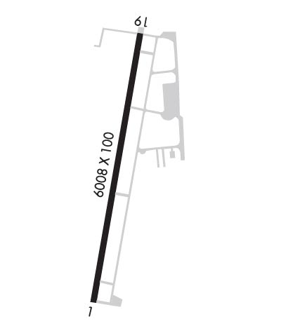
| Lat: N 3512.6 Long: W 09144.3 Elev: 265 Var: -02 Longest Runway: 6008 | ||
| Clr Del: 119.75 AWOS: 128.32 CTAF: 122.7 | ||
| ||||||
| ||||||
|
| Rwy | Rwy | |||||||
| 6008x100 | 6008' | 110.10 - 010° | 6008x100 | 6008' | ||||
| Runway ID | Single Wheel | Double Wheel | Double Tandem Wheel | Dual Double Wheel |
| 01/19 | 24,000 | N/A | N/A | N/A |
| These numbers are Advisory and are not limits. The Airport Manager should have more accurate Weight Limits | ||||
 Airport Diagram might not be current. | |
| Facility Name: | SEARCY MUNI |
| City Name: | SEARCY |
| County: | WHITE |
| State abbrev: | AR |
| State Name: | ARKANSAS |
| Ownership: | PUBLICLY OWNED |
| Use: | OPEN TO THE PUBLIC |
| Owner's Name: | CITY OF SEARCY |
| Address: | 401 WEST ARCH |
| SEARCY, AR 72143 | |
| Owner's Phone: | 501-268-2483 |
| Manager's Name: | ROGER PEARSON |
| Address: | 2609 S MAIN |
| SEARCY, AR 72143 | |
| Phone: | 501-279-1080 |
| FAA Region: | SOUTHWEST |
| FAA Field Office: | AOK |
| Date | Sunrise | Sunset |
|---|---|---|
| 09/24/21 Friday | 6:56 | 19:01 |
| 09/25/21 Saturday | 6:57 | 19:00 |
| 09/26/21 Sunday | 6:58 | 18:58 |
| 09/27/21 Monday | 6:59 | 18:57 |
| 09/28/21 Tuesday | 6:59 | 18:55 |
| 09/29/21 Wednesday | 7:00 | 18:54 |
| 09/30/21 Thursday | 7:01 | 18:53 |
| 10/01/21 Friday | 7:02 | 18:51 |
| 10/02/21 Saturday | 7:02 | 18:50 |
| 10/03/21 Sunday | 7:03 | 18:48 |
| 10/04/21 Monday | 7:04 | 18:47 |
| 10/05/21 Tuesday | 7:05 | 18:46 |
| 10/06/21 Wednesday | 7:06 | 18:44 |
| 10/07/21 Thursday | 7:06 | 18:43 |
| Airport Attendance Schedule | 7 Days A Week 0700-1800 |
| Airport Status | OPERATIONAL (This Status can change at any time - please check NOTAMS) |
| Airport Lighting Schedule | DUSK-DAWN. MIRL RY 01/19 PRESET LOW INTST; TO INCR INTST ACTVT - CTAF. |
| Airport Storage Available | Tie Downs |
| Extra Services Available | Crop Dusting, Charter, Flight Instruction, Aircraft Rental, Aircraft Sales |
| Wind Indicator | YES - (lighted) |
| Control Tower | NO |
| CTAF Frequency | 122.700 |
| Unicom Frequency | 122.700 |
| Rotating Beacon Color | CLEAR-GREEN (Light Land Airport) |
| Segmented Circle | NO |
| Landing Fee | NO |
| Airport Inspected | STATE - performed by STATE AERONAUTICAL PERSONNEL |
| Inspection Date | 08/12/2020 |
| Type of Fuel Available | Grade 100LL, JET A (freeze point -40C); -10100LL AVBL SELF SERVE WITH CREDIT CARD. FOR JET A FUEL OR SVC AFT HRS CALL 501-279-1080. |
| Airframe Repair Service | MAJOR |
| Power Plant Repair Service | MAJOR |
| Latitude | N3512.6 |
| Longitude | W09144.3 (ESTIMATED) |
| Arpt Elevation | 264ft (SURVEYED) |
| Magnetic Variation | 02E |
| 3 miles S | of SEARCY |
| Traffic Pattern Altitude | 800 |
| Sectional Chart | MEMPHIS |
| Operations (Reported) | Yearly | Avg. Daily |
|---|---|---|
| General Aviation Transient | 10000 | 27 |
| General Aviation Local | 20000 | 55 |
| Air Taxi | 1000 | 3 |
| Commerical | 0 | 0 |
| Commuter | 0 | 0 |
| Military | 560 | 2 |
| Aircraft based on Field | |
|---|---|
| General Aviation Singles | 47 |
| General Aviation Multi | 12 |
| Jet Aircraft | 3 |
| General Aviation Helicopters | 7 |
| Military Aircraft | 0 |
| Gliders | 0 |
| Ultralights | 0 |
| FSS on field | NO |
| FSS tie-in | JONESBORO |
| FSS Phone | 1-800-WX-BRIEF |
| Who issues Notams | SRC |
| Notam D service at airport | YES |
| ARTCC Name | MEMPHIS |
| Airport Certification | |
| Aircraft Rescue & Firefighting Index | None |
| Airport of Entry | No |
| Custom Landing Rights | No |
| Joint Civil/Military | No |
| Military Landing rights | YES |
| NATIONAL PLAN OF INTEGRATED AIRPORT SYSTEMS (NPIAS) |
| GRANT AGREEMENTS UNDER FAAP/ADAP/AIP |
| ASSURANCES PURSUANT TO TITLE VI, CIVIL RIGHTS ACT OF 1964 |
| NUMEROUS AGRICULTURAL ACFT OPNS FM FEB-NOV 500 FT AGL & BLO. |
| NUMEROUS GYROCOPTER OPNS DALGT HRS. |
| NUMEROUS STUDENT PILOT OPNS. |
| NO LINE OF SIGHT BTN RY ENDS - SMALL ACFT. |
| FOR CD WHEN UNA VIA FREQ CTC LITTLE ROCK APCH 501-379-2908 OR LITTLE ROCK ATCT 501-379-2911 |
Airport Communications & Frequencies:
| ||||||||||||||||
| Runway: 01 | Runway: 19 | ||
| Mag heading: | 11° | Mag heading: | 191° |
| Rwy Slope: | .48% Up | Rwy Slope: | -.48% Down |
| Approach: | ILS/DME | Approach: | |
| Pattern: | Left Traffic | Pattern: | Left Traffic |
| Markings: | PRECISION INSTRUMENT | Markings: | PRECISION INSTRUMENT |
| Marking Condition: | GOOD | Marking Condition: | GOOD |
| Arresting Dev: | Arresting Dev: | ||
| Lat & Long: | N3512.2 W09144.4 | Lat. & Long.: | N3513.1 W09144.1 |
| Elev: | 235.4 ft. MSL | Elev: | 264.5 ft. MSL |
| TCH: | 57 ft. AGL | TCH: | 40 ft. AGL |
| Visual Glide Path: | 3.00 degrees | Visual Glide Path: | 3.00 degrees |
| Displaced Threshold: | No | Displaced Threshold: | No |
| Touchdown Zone: | YES | Touchdown Zone: | YES |
| Touchdown Elev.: | 252.6 feet | Touchdown Elev.: | 264.5 feet |
| Visual Glide Slope: | 4-Light PAPI on LEFT side of Runway | Visual Glide Slope: | 4-Light PAPI on LEFT side of Runway |
| RVR Equipment: | RVR Equipment: | ||
| RVV Equipment: | NO | RVV Equipment: | NO |
| Approach Lights: | MALSR - 1,400 foot medium intensity approach lighting system with runway alignment indicator lights | Approach Lights: | |
| REIL: | NO | REIL: | YES |
| Centerline Lights: | NO | Centerline Lights: | NO |
| Touchdown lights: | NO | Touchdown lights: | NO |
| Runway Category: | Precision Instrument Runway | Runway Category: | Runway with a Non-precision Approach having visibility minimums greater than 3/4 mile |
| Declared Distances: | Declared Distances: | ||
| Obstructions: | Obstructions: | TREE | |
| Marked: | Marked: | NOT Marked/Lighted | |
| Clearance slope: | 50:1 | Clearance slope: | 34:1 |
| Obstruction height: | Obstruction height: | 25 feet AGL | |
| Dist. from runway: | Dist. from runway: | 1050 feet | |
| Centerline offset: | Centerline offset: | 300 feet right of centerline | |
| Comments: | Comments: |
Thanks for using FltPlan.com
all rights reserved © 1999-2021 by Flight Plan LLC
