
| SAN CARLOS SAN CARLOS CA |
| |
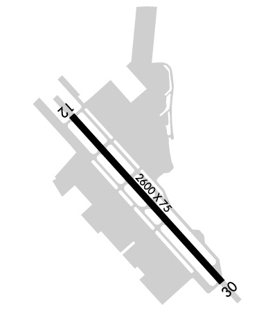
| Lat: N 3730.7 Long: W 12215.0 Elev: 6 Var: -15 Longest Runway: 2621 | ||
| Dept. ATIS: 125.9 Arr. ATIS: 125.9 AWOS: 125.9 Ground: 121.6 Tower: 119.0 | ||
| ||||||||||||||||||||||||||||||||||||||||||||
| ||||||||||||||||||||||||||||||||||||||||||||
| ||||||||||||||||||||||||||||||||||||||||||||
| Rwy | Rwy | |||||||
| 2621x75 | 2621' | 2621x75 | 2621' | |||||
| Runway ID | Single Wheel | Double Wheel | Double Tandem Wheel | Dual Double Wheel |
| 12/30 | 12,500 | N/A | N/A | N/A |
| These numbers are Advisory and are not limits. The Airport Manager should have more accurate Weight Limits | ||||
 Airport Diagram might not be current. | |
| Facility Name: | SAN CARLOS |
| City Name: | SAN CARLOS |
| County: | SAN MATEO |
| State abbrev: | CA |
| State Name: | CALIFORNIA |
| Ownership: | PUBLICLY OWNED |
| Use: | OPEN TO THE PUBLIC |
| Owner's Name: | SAN MATEO COUNTY |
| Address: | 555 COUNTY CENTER, 5TH FLOOR |
| REDWOOD CITY, CA 94063-1665 | |
| Owner's Phone: | 650-573-3700; DIRECTOR OF PUBLIC WORKS - JAMES PORTER. |
| Manager's Name: | GRETCHEN KELLY |
| Address: | 620 AIRPORT DR |
| SAN CARLOS, CA 94070 | |
| Phone: | 650-573-3700 |
| FAA Region: | WESTERN-PACIFIC |
| FAA Field Office: | SFO |
| Date | Sunrise | Sunset |
|---|---|---|
| 09/24/21 Friday | 6:58 | 19:03 |
| 09/25/21 Saturday | 6:59 | 19:02 |
| 09/26/21 Sunday | 7:00 | 19:00 |
| 09/27/21 Monday | 7:01 | 18:58 |
| 09/28/21 Tuesday | 7:02 | 18:57 |
| 09/29/21 Wednesday | 7:03 | 18:55 |
| 09/30/21 Thursday | 7:03 | 18:54 |
| 10/01/21 Friday | 7:04 | 18:52 |
| 10/02/21 Saturday | 7:05 | 18:51 |
| 10/03/21 Sunday | 7:06 | 18:49 |
| 10/04/21 Monday | 7:07 | 18:48 |
| 10/05/21 Tuesday | 7:08 | 18:46 |
| 10/06/21 Wednesday | 7:09 | 18:45 |
| 10/07/21 Thursday | 7:10 | 18:43 |
| Airport Attendance Schedule | 7 Days A Week 0600-2200 |
| Airport Status | OPERATIONAL (This Status can change at any time - please check NOTAMS) |
| Airport Lighting Schedule | WHEN ATCT CLSD; ACTVT MIRL RWY 12/30 & REIL RWY 12/30 - 119.0 |
| Airport Storage Available | Tie Downs |
| Extra Services Available | Charter, Flight Instruction, Aircraft Rental, Aircraft Sales |
| Wind Indicator | YES - (lighted) |
| Control Tower | YES |
| CTAF Frequency | 119.000 |
| Unicom Frequency | 122.950 |
| Rotating Beacon Color | CLEAR-GREEN (Light Land Airport) |
| Segmented Circle | YES |
| Landing Fee | NO |
| Airport Inspected | STATE - performed by STATE AERONAUTICAL PERSONNEL |
| Inspection Date | 01/15/2020 |
| Type of Fuel Available | Grade 100LL, JET A (freeze point -40C), JET AUL94 |
| Airframe Repair Service | MINOR |
| Power Plant Repair Service | MINOR |
| Latitude | N3730.7 |
| Longitude | W12215.0 (ESTIMATED) |
| Arpt Elevation | 5ft (SURVEYED) |
| Magnetic Variation | 15E |
| 2 miles NE | of SAN CARLOS |
| Traffic Pattern Altitude | 800; APPLIES TO BOTH-FIXED WING AND HEL. |
| Sectional Chart | SAN FRANCISCO |
| Operations (Reported) | Yearly | Avg. Daily |
|---|---|---|
| General Aviation Transient | 46254 | 127 |
| General Aviation Local | 54723 | 150 |
| Air Taxi | 14647 | 40 |
| Commerical | 0 | 0 |
| Commuter | 0 | 0 |
| Military | 356 | 1 |
| Aircraft based on Field | |
|---|---|
| General Aviation Singles | 287 |
| General Aviation Multi | 23 |
| Jet Aircraft | 4 |
| General Aviation Helicopters | 9 |
| Military Aircraft | 0 |
| Gliders | 0 |
| Ultralights | 0 |
| FSS on field | NO |
| FSS tie-in | OAKLAND |
| FSS Phone | 1-800-WX-BRIEF |
| Who issues Notams | SQL |
| Notam D service at airport | YES |
| ARTCC Name | OAKLAND |
| Airport Certification | |
| Aircraft Rescue & Firefighting Index | None |
| Airport of Entry | No |
| Custom Landing Rights | No |
| Joint Civil/Military | No |
| Military Landing rights | YES |
| NATIONAL PLAN OF INTEGRATED AIRPORT SYSTEMS (NPIAS) |
| GRANT AGREEMENTS UNDER FAAP/ADAP/AIP |
| ASSURANCES PURSUANT TO TITLE VI, CIVIL RIGHTS ACT OF 1964 |
| FOR CD WHEN ATCT IS CLSD CTC NORCAL APCH AT 916-361-3829. |
| RABBIT AVIATION 130.00 |
| LRG HEL SHOULD AVOID OVERFLIGHT OF DIRT INFIELD AREAS. |
| NO TGL OR STOP AND GO LDGS WHEN ATCT CLSD. |
| CALM WIND RWY 12. |
| NOISE SENSITIVE AREAS S THRU NE OF ARPT. FOR NOISE ABATEMENT PROCEDURES CTC AMGR (650) 573-3700. |
| MIGRATORY BIRD ACT ON & INVOF OF ARPT. |
| 100 FT STEEL TRANSMISSION TWRS AND POWERLINES LCTD 750 FT WEST AND PARALLEL TO RWY 12/30. |
| 7 FT LIGHTED DIKE LCTD IN RWY SAFETY AREA ON APCH END RWY 30. |
Airport Communications & Frequencies:
| |||||||||||||||||||||||||||||||||
| Runway: 12 | Runway: 30 | ||
| Mag heading: | 123° | Mag heading: | 303° |
| Rwy Slope: | .00% Up | Rwy Slope: | .00% Down |
| Approach: | Approach: | ||
| Pattern: | Left Traffic; HEL RIGHT TFC RWY 12/LEFT TFC RWY 30. | Pattern: | Right Traffic; FIXED-WING RIGHT TFC RWY 30/LEFT TFC RWY 12. |
| Markings: | NONPRECISION INSTRUMENT | Markings: | NONPRECISION INSTRUMENT |
| Marking Condition: | GOOD | Marking Condition: | GOOD |
| Arresting Dev: | Arresting Dev: | ||
| Lat & Long: | N3730.9 W12215.2 | Lat. & Long.: | N3730.6 W12214.8 |
| Elev: | 5.0 ft. MSL | Elev: | 5.1 ft. MSL |
| TCH: | 25 ft. AGL | TCH: | 25 ft. AGL |
| Visual Glide Path: | 3.00 degrees | Visual Glide Path: | 3.00 degrees |
| Displaced Threshold: | No | Displaced Threshold: | No |
| Touchdown Zone: | YES | Touchdown Zone: | YES |
| Touchdown Elev.: | 5.5 feet | Touchdown Elev.: | 5.5 feet |
| Visual Glide Slope: | 2-Box VASI on LEFT side of Runway | Visual Glide Slope: | 2-Box VASI on LEFT side of Runway |
| RVR Equipment: | RVR Equipment: | ||
| RVV Equipment: | NO | RVV Equipment: | NO |
| Approach Lights: | Approach Lights: | ||
| REIL: | YES | REIL: | YES |
| Centerline Lights: | NO | Centerline Lights: | NO |
| Touchdown lights: | NO | Touchdown lights: | NO |
| Runway Category: | Runway with a Visual Approach | Runway Category: | Runway with a Non-precision Approach |
| Declared Distances: | Declared Distances: | ||
| Obstructions: | POLE | Obstructions: | LEVEE |
| Marked: | NOT Marked/Lighted | Marked: | LIGHTED |
| Clearance slope: | 20:1 | Clearance slope: | |
| Obstruction height: | 18 feet AGL | Obstruction height: | 7 feet AGL |
| Dist. from runway: | 565 feet | Dist. from runway: | 200 feet |
| Centerline offset: | 80 right of centerline | Centerline offset: | 60 feet right of centerline |
| Comments: | Comments: | 7' LGTD DIKE 100' E OF CNTRLN AT THR, EXTENDING TO 60' E OF CNTRLN AT END OF PRIMARY SFC. |
Thanks for using FltPlan.com
all rights reserved © 1999-2021 by Flight Plan LLC
