| SHOW LOW RGNL SHOW LOW AZ |
| |
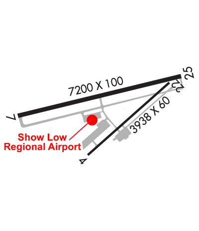
| Lat: N 3415.9 Long: W 11000.3 Elev: 6416 Var: -10 Longest Runway: 7202 | ||
| AWOS: 118.07 CTAF: 123.0 | ||
| |||||||||||||||||||||||||||||||||||||||||||||||||||||||||||||||||||||
| |||||||||||||||||||||||||||||||||||||||||||||||||||||||||||||||||||||
| |||||||||||||||||||||||||||||||||||||||||||||||||||||||||||||||||||||
| Rwy | Rwy | |||||||
| 3938x60 | 3938' | 3938x60 | 3938' | |||||
| 7202x100 | 6502' | 7202x100 | 7202' | |||||
| Runway ID | Single Wheel | Double Wheel | Double Tandem Wheel | Dual Double Wheel |
| 04/22 | 12,500 | N/A | N/A | N/A |
| 07/25 | 35,000 | 60,000 | N/A | N/A |
| These numbers are Advisory and are not limits. The Airport Manager should have more accurate Weight Limits | ||||
 Airport Diagram might not be current. | |
| Facility Name: | SHOW LOW RGNL |
| City Name: | SHOW LOW |
| County: | NAVAJO |
| State abbrev: | AZ |
| State Name: | ARIZONA |
| Ownership: | PUBLICLY OWNED |
| Use: | OPEN TO THE PUBLIC |
| Owner's Name: | CITY OF SHOWLOW |
| Address: | 180 N. 9TH PLACE |
| SHOW LOW, AZ 85901 | |
| Owner's Phone: | (928) 532-4000 |
| Manager's Name: | TOM BAHR |
| Address: | 3150 AIRPORT LOOP, #100 |
| SHOW LOW, AZ 85901 | |
| Phone: | (928) 532-4190 |
| FAA Region: | WESTERN-PACIFIC |
| FAA Field Office: | PHX |
| Date | Sunrise | Sunset |
|---|---|---|
| 09/24/21 Friday | 6:09 | 18:14 |
| 09/25/21 Saturday | 6:10 | 18:13 |
| 09/26/21 Sunday | 6:11 | 18:11 |
| 09/27/21 Monday | 6:11 | 18:10 |
| 09/28/21 Tuesday | 6:12 | 18:09 |
| 09/29/21 Wednesday | 6:13 | 18:07 |
| 09/30/21 Thursday | 6:14 | 18:06 |
| 10/01/21 Friday | 6:14 | 18:04 |
| 10/02/21 Saturday | 6:15 | 18:03 |
| 10/03/21 Sunday | 6:16 | 18:02 |
| 10/04/21 Monday | 6:17 | 18:00 |
| 10/05/21 Tuesday | 6:17 | 17:59 |
| 10/06/21 Wednesday | 6:18 | 17:58 |
| 10/07/21 Thursday | 6:19 | 17:56 |
| Airport Attendance Schedule | JAN-DEC 7 Days A Week 0700-1900 |
| Airport Status | OPERATIONAL (This Status can change at any time - please check NOTAMS) |
| Airport Lighting Schedule | ACTVT REIL RWY 07 & 25; PAPI RWY 07 & 25; MIRL RWY 07/25 - CTAF. |
| Airport Storage Available | Tie Downs |
| Extra Services Available | Charter, Flight Instruction, Aircraft Rental |
| Wind Indicator | YES - (lighted) |
| Control Tower | NO |
| CTAF Frequency | 123.000 |
| Unicom Frequency | 123.000 |
| Rotating Beacon Color | CLEAR-GREEN (Light Land Airport) |
| Segmented Circle | YES |
| Landing Fee | NO |
| Airport Inspected | STATE - performed by FAA AIRPORTS FIELD PERSONNEL |
| Inspection Date | 06/13/2019 |
| Type of Fuel Available | Grade 100LL, JET A (freeze point -40C); -10SELF-SERVICE FUEL AVBL CONTINOUSLY. |
| Airframe Repair Service | MINOR |
| Power Plant Repair Service | MINOR |
| Latitude | N3415.9 |
| Longitude | W11000.3 (ESTIMATED) |
| Arpt Elevation | 6415ft (SURVEYED) |
| Magnetic Variation | 10E |
| 2 miles E | of SHOW LOW |
| Traffic Pattern Altitude | 800 |
| Sectional Chart | PHOENIX |
| Operations (Reported) | Yearly | Avg. Daily |
|---|---|---|
| General Aviation Transient | 1120 | 3 |
| General Aviation Local | 2242 | 6 |
| Air Taxi | 8948 | 25 |
| Commerical | 0 | 0 |
| Commuter | 0 | 0 |
| Military | 72 | 0 |
| Aircraft based on Field | |
|---|---|
| General Aviation Singles | 32 |
| General Aviation Multi | 2 |
| Jet Aircraft | 0 |
| General Aviation Helicopters | 0 |
| Military Aircraft | 0 |
| Gliders | 0 |
| Ultralights | 0 |
| FSS on field | NO |
| FSS tie-in | PRESCOTT |
| FSS Phone | 1-800-WX-BRIEF |
| Who issues Notams | SOW |
| Notam D service at airport | YES |
| ARTCC Name | ALBUQUERQUE |
| Airport Certification | AIRPORT RECEIVING SCHEDULED AIR CARRIER SERVICE FROM CARRIERS CERTIFICATED BY THE CIVIL AERONAUTICS BOARD; RWY 04/22 NOT AVBL FOR SCHEDULED ACR OPNS WITH MORE THAN 9 PSGR SEATS OR UNSCHEDULED ACR AT LEAST 31 PSGR SEATS. |
| Aircraft Rescue & Firefighting Index | AIRPORT HAS A CERTIFICATE UNDER CFR PART 139 |
| Airport of Entry | No |
| Custom Landing Rights | No |
| Joint Civil/Military | No |
| Military Landing rights | YES |
| NATIONAL PLAN OF INTEGRATED AIRPORT SYSTEMS (NPIAS) |
| GRANT AGREEMENTS UNDER FAAP/ADAP/AIP |
| ASSURANCES PURSUANT TO TITLE VI, CIVIL RIGHTS ACT OF 1964 |
| PART 77 OBSTRNS-WIND SOCK IN 7-1 TRANSITION. |
| MILITARY TFC INVOF ARPT. |
| OVERNIGHT TRANSIENT FEES AND COMMERCIAL OP LANDING FEES APPLICABLE. |
| RWY 04/22 & 07/25 NOT CONNECTED BY PAVEMENT AT AER RWY 22. |
| SIMULTANEOUS OPS RWY 22 & 25 PROHIBITED. |
| ATTENDED 1400-0200Z. SELF-SERVICE FUEL AVBL CONTINUOUS. |
| FOR CD CTC ALBUQUERQUE ARTCC AT 505-856-4861. |
Airport Communications & Frequencies:
| |||||||||
| Runway: 04 | Runway: 22 | ||
| Mag heading: | 38° | Mag heading: | 218° |
| Rwy Slope: | -.31% Down | Rwy Slope: | .31% Up |
| Approach: | Approach: | ||
| Pattern: | Right Traffic | Pattern: | Left Traffic |
| Markings: | BASIC | Markings: | BASIC |
| Marking Condition: | GOOD | Marking Condition: | GOOD |
| Arresting Dev: | Arresting Dev: | ||
| Lat & Long: | N3415.6 W11000.4 | Lat. & Long.: | N3416.1 W10959.9 |
| Elev: | 6412.9 ft. MSL | Elev: | 6400.6 ft. MSL |
| TCH: | TCH: | ||
| Visual Glide Path: | Visual Glide Path: | ||
| Displaced Threshold: | No | Displaced Threshold: | No |
| Touchdown Zone: | YES | Touchdown Zone: | YES |
| Touchdown Elev.: | 6415.5 feet | Touchdown Elev.: | 6414.7 feet |
| Visual Glide Slope: | Visual Glide Slope: | ||
| RVR Equipment: | RVR Equipment: | ||
| RVV Equipment: | NO | RVV Equipment: | NO |
| Approach Lights: | Approach Lights: | ||
| REIL: | NO | REIL: | NO |
| Centerline Lights: | NO | Centerline Lights: | NO |
| Touchdown lights: | NO | Touchdown lights: | NO |
| Runway Category: | Runway with a Visual Approach | Runway Category: | Runway with a Visual Approach |
| Declared Distances: | TORA:3938' TODA:3938' ASDA:3938' LDA:3938' | Declared Distances: | TORA:3938' TODA:3938' ASDA:3938' LDA:3938' |
| Runway: 07 | Runway: 25 | ||
| Mag heading: | 66° | Mag heading: | 246° |
| Rwy Slope: | .01% Up | Rwy Slope: | -.01% Down |
| Approach: | Approach: | ||
| Pattern: | Left Traffic | Pattern: | Right Traffic |
| Markings: | NONPRECISION INSTRUMENT | Markings: | NONPRECISION INSTRUMENT |
| Marking Condition: | GOOD | Marking Condition: | GOOD |
| Arresting Dev: | Arresting Dev: | ||
| Lat & Long: | N3415.8 W11001.1 | Lat. & Long.: | N3416.1 W10959.7 |
| Elev: | 6399.2 ft. MSL | Elev: | 6399.8 ft. MSL |
| TCH: | 32 ft. AGL | TCH: | 49 ft. AGL |
| Visual Glide Path: | 3.00 degrees | Visual Glide Path: | 3.00 degrees |
| Displaced Threshold: | 700 feet | Displaced Threshold: | No |
| Touchdown Zone: | YES | Touchdown Zone: | YES |
| Touchdown Elev.: | 6404.1 feet | Touchdown Elev.: | 6405.0 feet |
| Visual Glide Slope: | 2-Light PAPI on LEFT side of Runway | Visual Glide Slope: | 2-Light PAPI on LEFT side of Runway |
| RVR Equipment: | RVR Equipment: | ||
| RVV Equipment: | NO | RVV Equipment: | NO |
| Approach Lights: | Approach Lights: | ||
| REIL: | YES | REIL: | YES |
| Centerline Lights: | NO | Centerline Lights: | NO |
| Touchdown lights: | NO | Touchdown lights: | NO |
| Runway Category: | Runway with a Visual Approach | Runway Category: | Runway with a Non-precision Approach having visibility minimums greater than 3/4 mile |
| Declared Distances: | TORA:7200' TODA:7200' ASDA:7200' LDA:6500' | Declared Distances: | TORA:7200' TODA:7200' ASDA:7200' LDA:7200' |
Thanks for using FltPlan.com
all rights reserved © 1999-2021 by Flight Plan LLC