
| MOORE COUNTY PINEHURST/STRN PINES NC |
| |
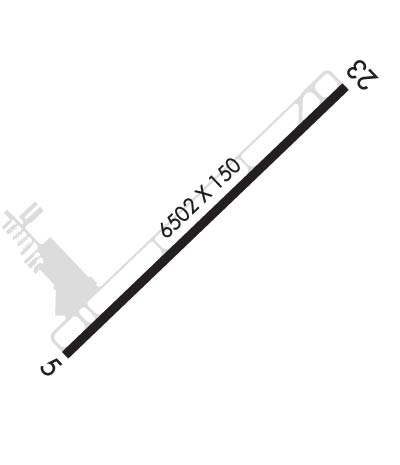
| Lat: N 3514.2 Long: W 07923.3 Elev: 459 Var: +08 Longest Runway: 6503 | ||
| Clr Del: 127.0 AWOS: 127.57 CTAF: 123.05 | ||
| ||||||||||||||||||||||||||||||||||||||||||||
| ||||||||||||||||||||||||||||||||||||||||||||
| ||||||||||||||||||||||||||||||||||||||||||||
| ||||||||||||||||||||||||||||||||||||||||||||
| Rwy | Rwy | |||||||
| 6503x150 | 5903' | 111.50 - 054° | 6503x150 | 6103' | ||||
| Runway ID | Single Wheel | Double Wheel | Double Tandem Wheel | Dual Double Wheel |
| 05/23 | 100,000 | 162,000 | N/A | N/A |
| These numbers are Advisory and are not limits. The Airport Manager should have more accurate Weight Limits | ||||
 Airport Diagram might not be current. | |
| Facility Name: | MOORE COUNTY |
| City Name: | PINEHURST/SOUTHERN PINES |
| County: | MOORE |
| State abbrev: | NC |
| State Name: | NORTH CAROLINA |
| Ownership: | PUBLICLY OWNED |
| Use: | OPEN TO THE PUBLIC |
| Owner's Name: | COUNTY OF MOORE |
| Address: | P O BOX 905 |
| CARTHAGE, NC 28327 | |
| Owner's Phone: | 910-692-3212 |
| Manager's Name: | RICK CLOUTIER |
| Address: | P.O. DRAWER 5809 |
| PINEHURST, NC 28374 | |
| Phone: | 910-692-3212 |
| FAA Region: | SOUTHERN |
| FAA Field Office: | MEM |
| Date | Sunrise | Sunset |
|---|---|---|
| 06/12/26 Friday | 6:02 | 20:32 |
| 06/13/26 Saturday | 6:02 | 20:33 |
| 06/14/26 Sunday | 6:02 | 20:33 |
| 06/15/26 Monday | 6:02 | 20:34 |
| 06/16/26 Tuesday | 6:02 | 20:34 |
| 06/17/26 Wednesday | 6:03 | 20:34 |
| 06/18/26 Thursday | 6:03 | 20:35 |
| 06/19/26 Friday | 6:03 | 20:35 |
| 06/20/26 Saturday | 6:03 | 20:35 |
| 06/21/26 Sunday | 6:03 | 20:35 |
| 06/22/26 Monday | 6:03 | 20:36 |
| 06/23/26 Tuesday | 6:04 | 20:36 |
| 06/24/26 Wednesday | 6:04 | 20:36 |
| 06/25/26 Thursday | 6:04 | 20:36 |
| Airport Attendance Schedule | 7 Days A Week 0800-2000 |
| Airport Status | OPERATIONAL (This Status can change at any time - please check NOTAMS) |
| Airport Lighting Schedule | ACTVT MALSR RWY 05; REIL RWY 23; HIRL RWY 05/23; TWY LGTS - CTAF. PAPI RWY 05 & 23 OPERS CONSLY. |
| Airport Storage Available | Tie Downs, Hanger |
| Extra Services Available | Charter, Flight Instruction, Aircraft Rental |
| Wind Indicator | YES - (lighted) |
| Control Tower | NO |
| CTAF Frequency | 123.050 |
| Unicom Frequency | 123.050 |
| Rotating Beacon Color | WG |
| Segmented Circle | NO |
| Landing Fee | NO |
| Airport Inspected | FEDERAL - performed by STATE AERONAUTICAL PERSONNEL |
| Inspection Date | 07/13/2023 |
| Type of Fuel Available | Grade 100LL, JET A |
| Airframe Repair Service | MAJOR |
| Power Plant Repair Service | MAJOR |
| Latitude | N3514.2 |
| Longitude | W07923.3 (ESTIMATED) |
| Arpt Elevation | 459ft (SURVEYED) |
| Magnetic Variation | 08W |
| 3 miles N | of PINEHURST/SOUTHERN PINES |
| Traffic Pattern Altitude | |
| Sectional Chart | CHARLOTTE |
| Operations (Reported) | Yearly | Avg. Daily |
|---|---|---|
| General Aviation Transient | 0 | 0 |
| General Aviation Local | 0 | 0 |
| Air Taxi | 0 | 0 |
| Commerical | 0 | 0 |
| Commuter | 0 | 0 |
| Military | 0 | 0 |
| Aircraft based on Field | |
|---|---|
| General Aviation Singles | 0 |
| General Aviation Multi | 0 |
| Jet Aircraft | 0 |
| General Aviation Helicopters | 0 |
| Military Aircraft | 0 |
| Gliders | 0 |
| Ultralights | 0 |
| FSS on field | NO |
| FSS tie-in | RALEIGH |
| FSS Phone | 1-800-WX-BRIEF |
| Who issues Notams | SOP |
| Notam D service at airport | YES |
| ARTCC Name | WASHINGTON |
| Airport Certification | CLSD TO UNSKED AIR CARRIER OPER WITH MORE THAN 30 PASSENGER SEATS; CALL AMGR 910-692-3212. |
| Aircraft Rescue & Firefighting Index | None |
| Airport of Entry | No |
| Custom Landing Rights | No |
| Joint Civil/Military | No |
| Military Landing rights | YES |
| NATIONAL PLAN OF INTEGRATED AIRPORT SYSTEMS (NPIAS) |
| GRANT AGREEMENTS UNDER FAAP/ADAP/AIP |
| SURPLUS PROPERTY AGREEMENT UNDER REGULATION 16-WAA |
| ASSURANCES PURSUANT TO TITLE VI, CIVIL RIGHTS ACT OF 1964 |
| NOISE ABATEMENT PROCEDURES IN EFFECT. CTC AMGR 910-692-3212. |
| BIRD ACTVTY ON & INVOF ARPT APR-OCT. |
| 12 HR PPR FOR JET OPNS CONDUCTED 2300-0600, CTC AMGR 910-692-3212. |
| MAINT AVBL. |
| FLT TRNG AVBL. |
| FOR CD CTC FAYETTEVILLE APCH 910-484-8012. |
| FIXED WING AIRCRAFT OPERATIONS NOT AUTHORIZED FROM ANY GRASS/TURF SURFACE. |
Airport Communications & Frequencies:
| ||||||||||||||||
| Runway: 05 | Runway: 23 | ||
| Mag heading: | 54° | Mag heading: | 234° |
| Rwy Slope: | -.40% Down | Rwy Slope: | .40% Up |
| Approach: | ILS/DME | Approach: | |
| Pattern: | Left Traffic | Pattern: | Left Traffic |
| Markings: | PRECISION INSTRUMENT | Markings: | PRECISION INSTRUMENT |
| Marking Condition: | GOOD | Marking Condition: | GOOD |
| Arresting Dev: | Arresting Dev: | ||
| Lat & Long: | N3513.9 W07923.8 | Lat. & Long.: | N3514.6 W07922.9 |
| Elev: | 459.3 ft. MSL | Elev: | 433.2 ft. MSL |
| TCH: | 40 ft. AGL | TCH: | 41 ft. AGL |
| Visual Glide Path: | 3.00 degrees | Visual Glide Path: | 3.00 degrees |
| Displaced Threshold: | 600 feet | Displaced Threshold: | 400 feet |
| Touchdown Zone: | YES | Touchdown Zone: | YES |
| Touchdown Elev.: | 455.2 feet | Touchdown Elev.: | 442.8 feet |
| Visual Glide Slope: | 4-Light PAPI on LEFT side of Runway | Visual Glide Slope: | 4-Light PAPI on RIGHT side of Runway |
| RVR Equipment: | RVR Equipment: | ||
| RVV Equipment: | NO | RVV Equipment: | NO |
| Approach Lights: | MALSR - 1,400 foot medium intensity approach lighting system with runway alignment indicator lights | Approach Lights: | |
| REIL: | NO | REIL: | YES |
| Centerline Lights: | NO | Centerline Lights: | NO |
| Touchdown lights: | NO | Touchdown lights: | NO |
| Runway Category: | Precision Instrument Runway | Runway Category: | Runway with a Non-precision Approach having visibility minimums greater than 3/4 mile |
| Declared Distances: | TORA:6502' TODA:6502' ASDA:6102' LDA:5502' | Declared Distances: | TORA:6502' TODA:6502' ASDA:6102' LDA:5722' |
| Obstructions: | TREES | Obstructions: | TREES |
| Marked: | NOT Marked/Lighted | Marked: | NOT Marked/Lighted |
| Clearance slope: | 21:1; APCH RATIO 30:1 AT DSPLCD THR 72 FT TREES. | Clearance slope: | 20:1 |
| Obstruction height: | 71 feet AGL | Obstruction height: | 38 feet AGL |
| Dist. from runway: | 1740 feet | Dist. from runway: | 987 feet |
| Centerline offset: | 456 right of centerline | Centerline offset: | 185 feet left of centerline |
| Comments: | Comments: |
Thanks for using FltPlan.com
all rights reserved © 1999-2026 by Flight Plan LLC
