
| SONORA MUNI SONORA TX |
| |
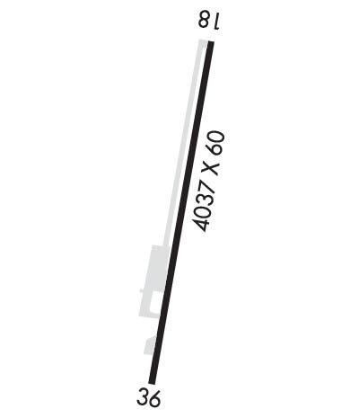
| Lat: N 3035.1 Long: W 10038.9 Elev: 2140 Var: -08 Longest Runway: 4037 | ||
| AWOS: 118.07 CTAF: 122.8 | ||
| ||||||
| ||||||
|
| Rwy | Rwy | |||||||
| 4037x60 | 3944' | 4037x60 | 3436' | |||||
| Runway ID | Single Wheel | Double Wheel | Double Tandem Wheel | Dual Double Wheel |
| 18/36 | 12,500 | N/A | N/A | N/A |
| These numbers are Advisory and are not limits. The Airport Manager should have more accurate Weight Limits | ||||
 Airport Diagram might not be current. | |
| Facility Name: | SONORA MUNI |
| City Name: | SONORA |
| County: | SUTTON |
| State abbrev: | TX |
| State Name: | TEXAS |
| Ownership: | PUBLICLY OWNED |
| Use: | OPEN TO THE PUBLIC |
| Owner's Name: | CITY OF SONORA |
| Address: | 201 E MAIN ST |
| SONORA, TX 76950 | |
| Owner's Phone: | 325-387-2558 |
| Manager's Name: | PETER R. DURAN; DIRECTOR OF PUBLIC WORKS/ARPT MGR. |
| Address: | 201 E MAIN ST |
| SONORA, TX 76950 | |
| Phone: | 325-387-2558; OFC PH EXT 308. AMGR CELL 325-326-1248. |
| FAA Region: | SOUTHWEST |
| FAA Field Office: | TEX |
| Date | Sunrise | Sunset |
|---|---|---|
| 09/24/21 Friday | 7:32 | 19:37 |
| 09/25/21 Saturday | 7:32 | 19:36 |
| 09/26/21 Sunday | 7:33 | 19:34 |
| 09/27/21 Monday | 7:34 | 19:33 |
| 09/28/21 Tuesday | 7:34 | 19:32 |
| 09/29/21 Wednesday | 7:35 | 19:31 |
| 09/30/21 Thursday | 7:35 | 19:29 |
| 10/01/21 Friday | 7:36 | 19:28 |
| 10/02/21 Saturday | 7:37 | 19:27 |
| 10/03/21 Sunday | 7:37 | 19:26 |
| 10/04/21 Monday | 7:38 | 19:24 |
| 10/05/21 Tuesday | 7:38 | 19:23 |
| 10/06/21 Wednesday | 7:39 | 19:22 |
| 10/07/21 Thursday | 7:40 | 19:21 |
| Airport Attendance Schedule | UNATTENDED |
| Airport Status | OPERATIONAL (This Status can change at any time - please check NOTAMS) |
| Airport Lighting Schedule | MIRL RWY 18/36 PRESET MED INTST ONLY. ACTVT PVASI RWYS 18 & 36 - CTAF. |
| Airport Storage Available | Tie Downs |
| Extra Services Available | NONE |
| Wind Indicator | YES - (lighted) |
| Control Tower | NO |
| CTAF Frequency | 122.800 |
| Unicom Frequency | 122.800 |
| Rotating Beacon Color | CLEAR-GREEN (Light Land Airport) |
| Segmented Circle | NO |
| Landing Fee | NO |
| Airport Inspected | STATE - performed by PRIVATE CONTRACT PERSONNEL |
| Inspection Date | 05/14/2021 |
| Type of Fuel Available | None |
| Airframe Repair Service | NONE |
| Power Plant Repair Service | NONE |
| Latitude | N3035.1 |
| Longitude | W10038.9 (ESTIMATED) |
| Arpt Elevation | 2139ft (SURVEYED) |
| Magnetic Variation | 08E |
| 1 miles N | of SONORA |
| Traffic Pattern Altitude | |
| Sectional Chart | SAN ANTONIO |
| Operations (Reported) | Yearly | Avg. Daily |
|---|---|---|
| General Aviation Transient | 500 | 1 |
| General Aviation Local | 1000 | 3 |
| Air Taxi | 0 | 0 |
| Commerical | 0 | 0 |
| Commuter | 0 | 0 |
| Military | 0 | 0 |
| Aircraft based on Field | |
|---|---|
| General Aviation Singles | 5 |
| General Aviation Multi | 0 |
| Jet Aircraft | 0 |
| General Aviation Helicopters | 0 |
| Military Aircraft | 0 |
| Gliders | 0 |
| Ultralights | 0 |
| FSS on field | NO |
| FSS tie-in | SAN ANGELO |
| FSS Phone | 1-800-WX-BRIEF |
| Who issues Notams | SOA |
| Notam D service at airport | YES |
| ARTCC Name | HOUSTON |
| Airport Certification | |
| Aircraft Rescue & Firefighting Index | None |
| Airport of Entry | No |
| Custom Landing Rights | No |
| Joint Civil/Military | No |
| Military Landing rights | No |
| THIS AIRPORT HAS BEEN SURVEYED BY THE NATIONAL GEODETIC SURVEY. |
| NSTD LGT-INCORRECT COLORS, SEVERAL LGTS OTS. |
| FOR CD CTC HOUSTON ARTCC AT 281-230-5622. |
Airport Communications & Frequencies:
| |||||||||
| Runway: 18 | Runway: 36 | ||
| Mag heading: | 182° | Mag heading: | 2° |
| Rwy Slope: | -.10% Down | Rwy Slope: | .10% Up |
| Approach: | Approach: | ||
| Pattern: | Left Traffic | Pattern: | Left Traffic |
| Markings: | NONPRECISION INSTRUMENT | Markings: | BASIC |
| Marking Condition: | POOR; MARKINGS FADED | Marking Condition: | POOR; MARKINGS FADED |
| Arresting Dev: | Arresting Dev: | ||
| Lat & Long: | N3035.5 W10038.8 | Lat. & Long.: | N3034.8 W10039.0 |
| Elev: | 2139.2 ft. MSL | Elev: | 2135.3 ft. MSL |
| TCH: | 25 ft. AGL | TCH: | 26 ft. AGL |
| Visual Glide Path: | 3.00 degrees | Visual Glide Path: | 3.00 degrees |
| Displaced Threshold: | 93 feet | Displaced Threshold: | 601 feet |
| Touchdown Zone: | YES | Touchdown Zone: | YES |
| Touchdown Elev.: | 2139.9 feet | Touchdown Elev.: | 2139.9 feet |
| Visual Glide Slope: | PULSATING/STEADY BURNING VASI ON LEFT SIDE OF RUNWAY | Visual Glide Slope: | PULSATING/STEADY BURNING VASI ON LEFT SIDE OF RUNWAY |
| RVR Equipment: | RVR Equipment: | ||
| RVV Equipment: | NO | RVV Equipment: | NO |
| Approach Lights: | Approach Lights: | ||
| REIL: | YES | REIL: | YES |
| Centerline Lights: | NO | Centerline Lights: | NO |
| Touchdown lights: | NO | Touchdown lights: | NO |
| Runway Category: | Runway with a Non-precision Approach | Runway Category: | Runway with a Visual Approach |
| Declared Distances: | Declared Distances: | ||
| Obstructions: | TREES; RWY 36 ALSO 32 FT RD, 201 FT DSTC, APCH SLOPE 0:1. | Obstructions: | PLINE |
| Marked: | NOT Marked/Lighted | Marked: | NOT Marked/Lighted |
| Clearance slope: | APCH RATIO 0:1 AT DSPLCD THR OVR 18 FT FENCE, 195 FT RIGHT. | Clearance slope: | APCH SLOPE 0:1 AT DSPLCD THR OVR 51 FT TREE, 0 FT DSTC, 215 FT R. |
| Obstruction height: | 14 feet AGL | Obstruction height: | 50 feet AGL |
| Dist. from runway: | 200 feet | Dist. from runway: | 200 feet |
| Centerline offset: | Centerline offset: | 239 feet left of centerline | |
| Comments: | 6-15 FT FENCE 10 FT FM RWY END ACRS THR, 12 FT SCTD BRUSH 10-200 FT FM THR. | Comments: | 8 FT FENCE 90 FT FM THR 0B; 25 FT RD 122 FT FM THR 0B; 50 FT POLE 32 FT FM THR 233 FT L. |
Thanks for using FltPlan.com
all rights reserved © 1999-2021 by Flight Plan LLC
