
| SIDNEY MUNI/LLOYD W. CARR FIEL SIDNEY NE |
| |
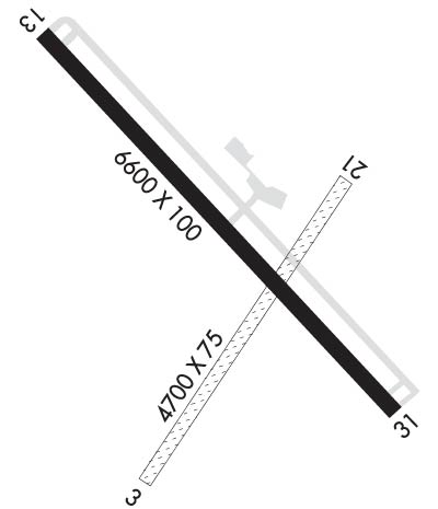
| Lat: N 4106.0 Long: W 10259.1 Elev: 4314 Var: -11 Longest Runway: 6600 | ||
| CTAF: 122.8 | ||
| ||||||
| ||||||
|
| Rwy | Rwy | |||||||
| 4705x75 | 4705' | 4705x75 | 4705' | |||||
| 6600x100 | 6600' | 6600x100 | 6600' | |||||
| Runway ID | Single Wheel | Double Wheel | Double Tandem Wheel | Dual Double Wheel |
| 03/21 | N/A | N/A | N/A | N/A |
| 13/31 | 32,000 | 52,000 | 96,000 | N/A |
| These numbers are Advisory and are not limits. The Airport Manager should have more accurate Weight Limits | ||||
 Airport Diagram might not be current. | |
| Facility Name: | SIDNEY MUNI/LLOYD W CARR FLD |
| City Name: | SIDNEY |
| County: | CHEYENNE |
| State abbrev: | NE |
| State Name: | NEBRASKA |
| Ownership: | PUBLICLY OWNED |
| Use: | OPEN TO THE PUBLIC |
| Owner's Name: | SIDNEY AIRPORT AUTHORITY; RON MEYER, CHAIRMAN, AIRPORT AUTHORITY |
| Address: | PO BOX 490 |
| SIDNEY, NE 69162-0490 | |
| Owner's Phone: | (308) 254-5058 |
| Manager's Name: | GEORGE LAPASEOTES |
| Address: | 11149 ROAD 16 |
| SIDNEY, NE 69162-4002 | |
| Phone: | (308) 254-5058 |
| FAA Region: | CENTRAL |
| FAA Field Office: | NONE |
| Date | Sunrise | Sunset |
|---|---|---|
| 09/24/21 Friday | 6:41 | 18:46 |
| 09/25/21 Saturday | 6:42 | 18:44 |
| 09/26/21 Sunday | 6:43 | 18:43 |
| 09/27/21 Monday | 6:44 | 18:41 |
| 09/28/21 Tuesday | 6:45 | 18:39 |
| 09/29/21 Wednesday | 6:46 | 18:38 |
| 09/30/21 Thursday | 6:47 | 18:36 |
| 10/01/21 Friday | 6:48 | 18:34 |
| 10/02/21 Saturday | 6:49 | 18:32 |
| 10/03/21 Sunday | 6:50 | 18:31 |
| 10/04/21 Monday | 6:51 | 18:29 |
| 10/05/21 Tuesday | 6:53 | 18:28 |
| 10/06/21 Wednesday | 6:54 | 18:26 |
| 10/07/21 Thursday | 6:55 | 18:24 |
| Airport Attendance Schedule | 7 Days A Week 0700-1800; AFTER HRS CALL 308-254-5058. |
| Airport Status | OPERATIONAL (This Status can change at any time - please check NOTAMS) |
| Airport Lighting Schedule | DUSK-DAWN. ACTVT HIRL RY 13/31 & REIL RYS 13 & 31 - CTAF. |
| Airport Storage Available | Tie Downs, Hanger |
| Extra Services Available | Air Ambulance, Flight Instruction, Aircraft Rental |
| Wind Indicator | YES - (unlit) |
| Control Tower | NO |
| CTAF Frequency | 122.800 |
| Unicom Frequency | 122.800 |
| Rotating Beacon Color | CLEAR-GREEN (Light Land Airport) |
| Segmented Circle | YES |
| Landing Fee | NO |
| Airport Inspected | STATE - performed by STATE AERONAUTICAL PERSONNEL |
| Inspection Date | 05/14/2019 |
| Type of Fuel Available | Grade 100LL, JET A (freeze point -40C) |
| Airframe Repair Service | MAJOR |
| Power Plant Repair Service | MINOR |
| Latitude | N4106.0 |
| Longitude | W10259.1 (ESTIMATED) |
| Arpt Elevation | 4314ft (SURVEYED) |
| Magnetic Variation | 11E |
| 3 miles S | of SIDNEY |
| Traffic Pattern Altitude | |
| Sectional Chart | CHEYENNE |
| Operations (Reported) | Yearly | Avg. Daily |
|---|---|---|
| General Aviation Transient | 2000 | 5 |
| General Aviation Local | 1700 | 5 |
| Air Taxi | 300 | 1 |
| Commerical | 0 | 0 |
| Commuter | 0 | 0 |
| Military | 100 | 0 |
| Aircraft based on Field | |
|---|---|
| General Aviation Singles | 19 |
| General Aviation Multi | 1 |
| Jet Aircraft | 1 |
| General Aviation Helicopters | 1 |
| Military Aircraft | 0 |
| Gliders | 0 |
| Ultralights | 0 |
| FSS on field | NO |
| FSS tie-in | COLUMBUS |
| FSS Phone | 1-800-WX-BRIEF |
| Who issues Notams | SNY |
| Notam D service at airport | YES |
| ARTCC Name | DENVER |
| Airport Certification | |
| Aircraft Rescue & Firefighting Index | None |
| Airport of Entry | No |
| Custom Landing Rights | No |
| Joint Civil/Military | No |
| Military Landing rights | YES |
| NATIONAL PLAN OF INTEGRATED AIRPORT SYSTEMS (NPIAS) |
| GRANT AGREEMENTS UNDER FAAP/ADAP/AIP |
| ADVANCE PLANNING AGREEMENT UNDER FAAP |
| ASSURANCES PURSUANT TO TITLE VI, CIVIL RIGHTS ACT OF 1964 |
| FOR CD IF UNA TO CTC ON FSS FREQ, CTC DENVER ARTCC AT 303-651-4257. |
Airport Communications & Frequencies:
| |||||||||
| Runway: 03 | Runway: 21 | ||
| Mag heading: | 25° | Mag heading: | 205° |
| Rwy Slope: | -.28% Down | Rwy Slope: | .28% Up |
| Approach: | Approach: | ||
| Pattern: | Left Traffic | Pattern: | Left Traffic |
| Markings: | Markings: | ||
| Marking Condition: | FAIR | Marking Condition: | FAIR |
| Arresting Dev: | Arresting Dev: | ||
| Lat & Long: | N4105.5 W10259.4 | Lat. & Long.: | N4106.2 W10258.8 |
| Elev: | 4297.5 ft. MSL | Elev: | 4284.4 ft. MSL |
| TCH: | TCH: | ||
| Visual Glide Path: | Visual Glide Path: | ||
| Displaced Threshold: | No | Displaced Threshold: | No |
| Touchdown Zone: | YES | Touchdown Zone: | YES |
| Touchdown Elev.: | 4297.7 feet | Touchdown Elev.: | 4294.0 feet |
| Visual Glide Slope: | Visual Glide Slope: | ||
| RVR Equipment: | RVR Equipment: | ||
| RVV Equipment: | NO | RVV Equipment: | NO |
| Approach Lights: | Approach Lights: | ||
| REIL: | NO | REIL: | NO |
| Centerline Lights: | NO | Centerline Lights: | NO |
| Touchdown lights: | NO | Touchdown lights: | NO |
| Runway Category: | Runway with a Visual Approach | Runway Category: | Runway with a Visual Approach |
| Declared Distances: | Declared Distances: | ||
| Obstructions: | PLINE | Obstructions: | HILL |
| Marked: | NOT Marked/Lighted | Marked: | NOT Marked/Lighted |
| Clearance slope: | 28:1 | Clearance slope: | 40:1 |
| Obstruction height: | 20 feet AGL | Obstruction height: | 9 feet AGL |
| Dist. from runway: | 566 feet | Dist. from runway: | 366 feet |
| Centerline offset: | Centerline offset: | ||
| Comments: | Comments: |
| Runway: 13 | Runway: 31 | ||
| Mag heading: | 124° | Mag heading: | 304° |
| Rwy Slope: | -.49% Down | Rwy Slope: | .49% Up |
| Approach: | Approach: | ||
| Pattern: | Left Traffic | Pattern: | Left Traffic |
| Markings: | NONPRECISION INSTRUMENT | Markings: | NONPRECISION INSTRUMENT |
| Marking Condition: | GOOD | Marking Condition: | GOOD |
| Arresting Dev: | Arresting Dev: | ||
| Lat & Long: | N4106.5 W10259.6 | Lat. & Long.: | N4105.7 W10258.6 |
| Elev: | 4314.2 ft. MSL | Elev: | 4281.9 ft. MSL |
| TCH: | 45 ft. AGL | TCH: | 50 ft. AGL |
| Visual Glide Path: | 3.00 degrees | Visual Glide Path: | 3.00 degrees |
| Displaced Threshold: | No | Displaced Threshold: | No |
| Touchdown Zone: | YES | Touchdown Zone: | YES |
| Touchdown Elev.: | 4314.2 feet | Touchdown Elev.: | 4291.1 feet |
| Visual Glide Slope: | 2-Light PAPI on LEFT side of Runway | Visual Glide Slope: | 2-Light PAPI on LEFT side of Runway; UNUSBL BYD 8 DEGS RIGHT OF CNTRLN. |
| RVR Equipment: | RVR Equipment: | ||
| RVV Equipment: | NO | RVV Equipment: | NO |
| Approach Lights: | Approach Lights: | ||
| REIL: | YES | REIL: | YES |
| Centerline Lights: | NO | Centerline Lights: | NO |
| Touchdown lights: | NO | Touchdown lights: | NO |
| Runway Category: | Runway with a Non-precision Approach having visibility minimums greater than 3/4 mile | Runway Category: | Runway with a Non-precision Approach having visibility minimums greater than 3/4 mile |
| Declared Distances: | Declared Distances: |
Thanks for using FltPlan.com
all rights reserved © 1999-2021 by Flight Plan LLC
