
| CHESTER CHESTER CT |
| |
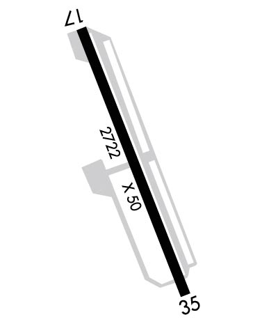
| Lat: N 4123.0 Long: W 07230.3 Elev: 416 Var: +13 Longest Runway: 2722 | ||
| AWOS: 118.32 CTAF: 122.72 | ||
| ||||||||||||||||||||||||||||||||||||||||||||
| ||||||||||||||||||||||||||||||||||||||||||||
| ||||||||||||||||||||||||||||||||||||||||||||
| Rwy | Rwy | |||||||
| 2722x50 | 2163' | 2722x50 | 2722' | |||||
| Runway ID | Single Wheel | Double Wheel | Double Tandem Wheel | Dual Double Wheel |
| 17/35 | 8,500 | N/A | N/A | N/A |
| These numbers are Advisory and are not limits. The Airport Manager should have more accurate Weight Limits | ||||
 Airport Diagram might not be current. | |
| Facility Name: | CHESTER |
| City Name: | CHESTER |
| County: | MIDDLESEX |
| State abbrev: | CT |
| State Name: | CONNECTICUT |
| Ownership: | PRIVATELY OWNED |
| Use: | OPEN TO THE PUBLIC |
| Owner's Name: | WHELEN AVIATION |
| Address: | WINTHROP ROAD |
| CHESTER, CT 06412 | |
| Owner's Phone: | 860-526-4321 |
| Manager's Name: | CHARLES F. GREENEY, JR. |
| Address: | WHELEN ENGINEERING, 51 WINTHROP ROAD |
| CHESTER, CT 06412 | |
| Phone: | 860-718-2109; CELL 860-853-0993. |
| FAA Region: | NEW ENGLAND |
| FAA Field Office: | NONE |
| Date | Sunrise | Sunset |
|---|---|---|
| 07/05/26 Sunday | 5:22 | 20:27 |
| 07/06/26 Monday | 5:23 | 20:26 |
| 07/07/26 Tuesday | 5:24 | 20:26 |
| 07/08/26 Wednesday | 5:24 | 20:26 |
| 07/09/26 Thursday | 5:25 | 20:25 |
| 07/10/26 Friday | 5:26 | 20:25 |
| 07/11/26 Saturday | 5:26 | 20:24 |
| 07/12/26 Sunday | 5:27 | 20:24 |
| 07/13/26 Monday | 5:28 | 20:23 |
| 07/14/26 Tuesday | 5:29 | 20:23 |
| 07/15/26 Wednesday | 5:29 | 20:22 |
| 07/16/26 Thursday | 5:30 | 20:22 |
| 07/17/26 Friday | 5:31 | 20:21 |
| 07/18/26 Saturday | 5:32 | 20:20 |
| Airport Attendance Schedule | APR-OCT 7 Days A Week 0900-2000, NOV-MAR 7 Days A Week 0900-1800 |
| Airport Status | OPERATIONAL (This Status can change at any time - please check NOTAMS) |
| Airport Lighting Schedule | SS-SR |
| Airport Storage Available | Tie Downs, Hanger |
| Extra Services Available | Air Freight, Avionics, Charter, Flight Instruction, Aircraft Rental, Aircraft Sales |
| Wind Indicator | YES - (lighted) |
| Control Tower | NO |
| CTAF Frequency | 122.725 |
| Unicom Frequency | 122.725 |
| Rotating Beacon Color | WG; ROTG BCN OPRS 24/7. |
| Segmented Circle | NO |
| Landing Fee |
| Airport Inspected | STATE - performed by PRIVATE CONTRACT PERSONNEL |
| Inspection Date | 08/19/2022 |
| Type of Fuel Available | Grade 100LL; -10SELF SVC FUEL AVBL WITH CREDIT CARD. |
| Airframe Repair Service | MAJOR |
| Power Plant Repair Service | MAJOR |
| Latitude | N4123.0 |
| Longitude | W07230.3 (ESTIMATED) |
| Arpt Elevation | 416ft (ESTIMATED) |
| Magnetic Variation | 13W |
| 3 miles SW | of CHESTER |
| Traffic Pattern Altitude | |
| Sectional Chart | NEW YORK |
| Operations (Reported) | Yearly | Avg. Daily |
|---|---|---|
| General Aviation Transient | 0 | 0 |
| General Aviation Local | 0 | 0 |
| Air Taxi | 0 | 0 |
| Commerical | 0 | 0 |
| Commuter | 0 | 0 |
| Military | 0 | 0 |
| Aircraft based on Field | |
|---|---|
| General Aviation Singles | 0 |
| General Aviation Multi | 0 |
| Jet Aircraft | 0 |
| General Aviation Helicopters | 0 |
| Military Aircraft | 0 |
| Gliders | 0 |
| Ultralights | 0 |
| FSS on field | NO |
| FSS tie-in | BRIDGEPORT |
| FSS Phone | 1-800-WX-BRIEF |
| Who issues Notams | SNC |
| Notam D service at airport | YES |
| ARTCC Name | NEW YORK |
| Airport Certification | |
| Aircraft Rescue & Firefighting Index | None |
| Airport of Entry | No |
| Custom Landing Rights | No |
| Joint Civil/Military | No |
| Military Landing rights | No |
| FOR CD CTC NEW YORK APCH AT 516-683-2449. |
| (DSPLCD THR APCH RATIO, RWY 17) DSPLCD THR 5 FT HYR THAN AER. |
| RWY 17/3 5 NON-STD MIRL FIXTURES/CONES. |
Airport Communications & Frequencies:
| ||||||||||||||
| Runway: 17 | Runway: 35 | ||
| Mag heading: | 174° | Mag heading: | 354° |
| Rwy Slope: | .48% Up | Rwy Slope: | -.48% Down |
| Approach: | Approach: | ||
| Pattern: | Left Traffic | Pattern: | Left Traffic |
| Markings: | NONSTANDARD | Markings: | NONSTANDARD |
| Marking Condition: | FAIR | Marking Condition: | FAIR |
| Arresting Dev: | Arresting Dev: | ||
| Lat & Long: | N4123.2 W07230.4 | Lat. & Long.: | N4122.8 W07230.2 |
| Elev: | 395.0 ft. MSL | Elev: | 408.0 ft. MSL |
| TCH: | TCH: | ||
| Visual Glide Path: | Visual Glide Path: | ||
| Displaced Threshold: | 559 feet; DSPLCD THR MARKED BUT NOT LGTD. | Displaced Threshold: | No |
| Touchdown Zone: | YES | Touchdown Zone: | YES |
| Touchdown Elev.: | 416.0 feet | Touchdown Elev.: | 416.0 feet |
| Visual Glide Slope: | Visual Glide Slope: | ||
| RVR Equipment: | RVR Equipment: | ||
| RVV Equipment: | NO | RVV Equipment: | NO |
| Approach Lights: | Approach Lights: | ||
| REIL: | YES | REIL: | YES |
| Centerline Lights: | NO | Centerline Lights: | NO |
| Touchdown lights: | NO | Touchdown lights: | NO |
| Runway Category: | Runway with a Non-precision Approach | Runway Category: | Runway with a Non-precision Approach |
| Declared Distances: | Declared Distances: | ||
| Obstructions: | TREE | Obstructions: | |
| Marked: | NOT Marked/Lighted | Marked: | |
| Clearance slope: | 1:1; OBSTN CLNC SLOPE 14:1 TO DTHR. | Clearance slope: | 20:1 |
| Obstruction height: | 50 feet AGL | Obstruction height: | |
| Dist. from runway: | 207 feet | Dist. from runway: | |
| Centerline offset: | 66 right of centerline | Centerline offset: | |
| Comments: | +5 FT TREE 56 FT DSTC, 60 FT L. | Comments: | +3 FT BRUSH, 0 FT FM THR, 103 FT R. |
Thanks for using FltPlan.com
all rights reserved © 1999-2026 by Flight Plan LLC