
| SANTA MARIA PUB/HANCOCK SANTA MARIA CA |
| |
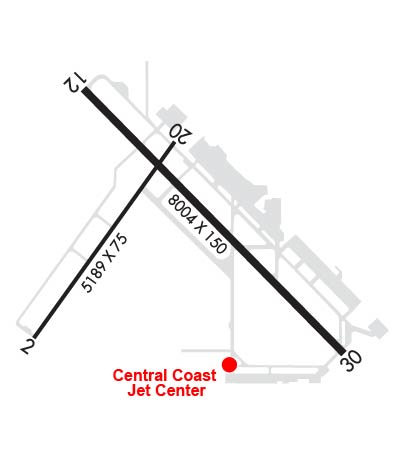
| Lat: N 3454.0 Long: W 12027.5 Elev: 261 Var: -14 Longest Runway: 8004 | ||
| Dept. ATIS: 121.15 Arr. ATIS: 121.15 Ground: 121.9 Tower: 118.3 | ||
| ||||||
| ||||||
| ||||||
|
| Rwy | Rwy | |||||||
| 5199x75 | 5199' | 5199x75 | 5199' | |||||
| 8004x150 | 8004' | 108.90 - 120° | 8004x150 | 8004' | ||||
| Runway ID | Single Wheel | Double Wheel | Double Tandem Wheel | Dual Double Wheel |
| 02/20 | 70,000 | 90,000 | 150,000 | N/A |
| 12/30 | 75,000 | 181,000 | 400,000 | N/A |
| These numbers are Advisory and are not limits. The Airport Manager should have more accurate Weight Limits | ||||
 Airport Diagram might not be current. | |
| Facility Name: | SANTA MARIA PUB/CAPT G ALLAN HANCOCK FLD |
| City Name: | SANTA MARIA |
| County: | SANTA BARBARA |
| State abbrev: | CA |
| State Name: | CALIFORNIA |
| Ownership: | PUBLICLY OWNED |
| Use: | OPEN TO THE PUBLIC |
| Owner's Name: | SANTA MARIA PUBLIC APT DIST |
| Address: | 3217 TERMINAL DR |
| SANTA MARIA, CA 93455 | |
| Owner's Phone: | 805-922-1726 |
| Manager's Name: | MARTIN PEHL |
| Address: | 3217 TERMINAL DR |
| SANTA MARIA, CA 93455 | |
| Phone: | 805-922-1726 |
| FAA Region: | WESTERN-PACIFIC |
| FAA Field Office: | LAX |

| Date | Sunrise | Sunset |
|---|---|---|
| 06/08/26 Monday | 5:48 | 20:14 |
| 06/09/26 Tuesday | 5:48 | 20:15 |
| 06/10/26 Wednesday | 5:48 | 20:15 |
| 06/11/26 Thursday | 5:48 | 20:15 |
| 06/12/26 Friday | 5:48 | 20:16 |
| 06/13/26 Saturday | 5:48 | 20:16 |
| 06/14/26 Sunday | 5:48 | 20:17 |
| 06/15/26 Monday | 5:48 | 20:17 |
| 06/16/26 Tuesday | 5:48 | 20:17 |
| 06/17/26 Wednesday | 5:48 | 20:18 |
| 06/18/26 Thursday | 5:48 | 20:18 |
| 06/19/26 Friday | 5:48 | 20:18 |
| 06/20/26 Saturday | 5:48 | 20:19 |
| 06/21/26 Sunday | 5:48 | 20:19 |
| Airport Attendance Schedule | 7 Days A Week 0600-2200 |
| Airport Status | OPERATIONAL (This Status can change at any time - please check NOTAMS) |
| Airport Lighting Schedule | WHEN ATCT CLSD ACTVT MALSR RWY 12; PAPI RWY 30; HIRL RWY 12/30; TWY LIGHTS - CTAF. PAPI RWY 12 OPER CONSLY. |
| Airport Storage Available | Tie Downs |
| Extra Services Available | Air Freight, Avionics, Charter, Flight Instruction, Aircraft Rental, Aircraft Sales |
| Wind Indicator | YES - (lighted) |
| Control Tower | YES |
| CTAF Frequency | 118.300 |
| Unicom Frequency | 122.950 |
| Rotating Beacon Color | WG |
| Segmented Circle | YES |
| Landing Fee | NO |
| Airport Inspected | FEDERAL - performed by FAA AIRPORTS FIELD PERSONNEL |
| Inspection Date | 04/03/2025 |
| Type of Fuel Available | Grade 100LL, JET A (freeze point -40C); -10ACFT FUEL SERVICING AVAILABLE 129.975. |
| Airframe Repair Service | MAJOR |
| Power Plant Repair Service | MAJOR |
| Latitude | N3454.0 |
| Longitude | W12027.5 (ESTIMATED) |
| Arpt Elevation | 261ft (SURVEYED) |
| Magnetic Variation | 14E |
| 3 miles S | of SANTA MARIA |
| Traffic Pattern Altitude | TPA 1000; TURBOJET & PURE JET 1500. |
| Sectional Chart | LOS ANGELES |
| Operations (Reported) | Yearly | Avg. Daily |
|---|---|---|
| General Aviation Transient | 0 | 0 |
| General Aviation Local | 0 | 0 |
| Air Taxi | 0 | 0 |
| Commerical | 0 | 0 |
| Commuter | 0 | 0 |
| Military | 0 | 0 |
| Aircraft based on Field | |
|---|---|
| General Aviation Singles | 0 |
| General Aviation Multi | 0 |
| Jet Aircraft | 0 |
| General Aviation Helicopters | 0 |
| Military Aircraft | 0 |
| Gliders | 0 |
| Ultralights | 0 |
| FSS on field | NO |
| FSS tie-in | HAWTHORNE |
| FSS Phone | 1-800-WX-BRIEF |
| Who issues Notams | SMX |
| Notam D service at airport | YES |
| ARTCC Name | LOS ANGELES |
| Airport Certification | AIRPORT RECEIVING SCHEDULED AIR CARRIER SERVICE FROM CARRIERS CERTIFICATED BY THE CIVIL AERONAUTICS BOARD; CLSD TO SUPPLL PART 121 AND PART 135 ACR OPNS EXCP 24 HRS PPR, CALL AMGR (805) 922-1726 WKDAYS 0800-1700. |
| Aircraft Rescue & Firefighting Index | AIRPORT HAS A CERTIFICATE UNDER CFR PART 139 |
| Airport of Entry | No |
| Custom Landing Rights | No |
| Joint Civil/Military | No |
| Military Landing rights | YES |
| NATIONAL PLAN OF INTEGRATED AIRPORT SYSTEMS (NPIAS) |
| GRANT AGREEMENTS UNDER FAAP/ADAP/AIP |
| SURPLUS PROPERTY AGREEMENT UNDER PUBLIC LAW 289 |
| ASSURANCES PURSUANT TO TITLE VI, CIVIL RIGHTS ACT OF 1964 |
| CAUTION PARALLEL LGTD ROAD LESS THAN 1/4 MILE NW OF RY 12/30. |
| TRANSIENT PILOTS REMAIN CLEAR OF COMMERCIAL RAMP AND TERMINAL. |
| SELF SERVE FUEL 100LL AVBL 24 HRS LOCATED NORTH OF TOWER. |
| CALM WIND LESS THAN 8 KNOTS USE RWY 30. |
| NO TGL OPNS; LANDING PRACTICE OR PRACTICE INSTRUMENT APPROACHES 2200-0700. |
| PORTIONS OF TWY J NOT VISIBLE FM ATCT & UNLGTD. |
| NUMEROUS BIRDS ON AND INVOF ARPT. |
| RWY 02/2 0 RWY 02/20 NOT AVBL FOR PART 121/PART 380 OPS WITH SKED PAX CARRYING OPS MORE THAN 9 PAX SEATS AND NON-SKED PAX CARRYING OPS MORE THAN 30 PAX SEATS. |
| RWY 02/2 0 PCR VALUE: 200/F/A/Y/T |
| RWY 12/3 0 PCR VALUE: 442/F/B/X/U |
Airport Communications & Frequencies:
| |||||||||||||||||||||||||||
| Runway: 02 | Runway: 20 | ||
| Mag heading: | 22° | Mag heading: | 202° |
| Rwy Slope: | .32% Up | Rwy Slope: | -.32% Down |
| Approach: | Approach: | ||
| Pattern: | Right Traffic | Pattern: | Left Traffic |
| Markings: | BASIC | Markings: | BASIC |
| Marking Condition: | GOOD | Marking Condition: | GOOD |
| Arresting Dev: | Arresting Dev: | ||
| Lat & Long: | N3453.6 W12028.1 | Lat. & Long.: | N3454.3 W12027.5 |
| Elev: | 209.5 ft. MSL | Elev: | 226.2 ft. MSL |
| TCH: | TCH: | ||
| Visual Glide Path: | Visual Glide Path: | ||
| Displaced Threshold: | No | Displaced Threshold: | No |
| Touchdown Zone: | YES | Touchdown Zone: | YES |
| Touchdown Elev.: | 216.9 feet | Touchdown Elev.: | 226.7 feet |
| Visual Glide Slope: | Visual Glide Slope: | ||
| RVR Equipment: | RVR Equipment: | ||
| RVV Equipment: | NO | RVV Equipment: | NO |
| Approach Lights: | Approach Lights: | ||
| REIL: | NO | REIL: | NO |
| Centerline Lights: | NO | Centerline Lights: | NO |
| Touchdown lights: | NO | Touchdown lights: | NO |
| Runway Category: | Runway with a Visual Approach | Runway Category: | Runway with a Visual Approach |
| Declared Distances: | TORA:5199' TODA:5199' ASDA:5199' LDA:5199' | Declared Distances: | TORA:5199' TODA:5199' ASDA:5199' LDA:5199' |
| Obstructions: | Obstructions: | TREES | |
| Marked: | Marked: | NOT Marked/Lighted | |
| Clearance slope: | 50:1 | Clearance slope: | 28:1 |
| Obstruction height: | Obstruction height: | 121 feet AGL | |
| Dist. from runway: | Dist. from runway: | 3640 feet | |
| Centerline offset: | Centerline offset: | 350 feet right of centerline | |
| Comments: | Comments: |
| Runway: 12 | Runway: 30 | ||
| Mag heading: | 121° | Mag heading: | 301° |
| Rwy Slope: | .55% Up | Rwy Slope: | -.55% Down |
| Approach: | ILS/DME | Approach: | |
| Pattern: | Right Traffic | Pattern: | Left Traffic |
| Markings: | PRECISION INSTRUMENT | Markings: | PRECISION INSTRUMENT |
| Marking Condition: | GOOD | Marking Condition: | GOOD |
| Arresting Dev: | Arresting Dev: | ||
| Lat & Long: | N3454.5 W12027.9 | Lat. & Long.: | N3453.6 W12026.7 |
| Elev: | 216.8 ft. MSL | Elev: | 261.1 ft. MSL |
| TCH: | 55 ft. AGL | TCH: | 46 ft. AGL |
| Visual Glide Path: | 3.00 degrees | Visual Glide Path: | 3.60 degrees |
| Displaced Threshold: | No | Displaced Threshold: | No |
| Touchdown Zone: | YES | Touchdown Zone: | YES |
| Touchdown Elev.: | 230.1 feet | Touchdown Elev.: | 261.2 feet |
| Visual Glide Slope: | 4-Light PAPI on RIGHT side of Runway | Visual Glide Slope: | 4-Light PAPI on RIGHT side of Runway |
| RVR Equipment: | TOUCHDOWN | RVR Equipment: | ROLLOUT |
| RVV Equipment: | NO | RVV Equipment: | NO |
| Approach Lights: | MALSR - 1,400 foot medium intensity approach lighting system with runway alignment indicator lights | Approach Lights: | |
| REIL: | NO | REIL: | NO |
| Centerline Lights: | NO | Centerline Lights: | NO |
| Touchdown lights: | NO | Touchdown lights: | NO |
| Runway Category: | Precision Instrument Runway | Runway Category: | Runway with a Non-precision Approach having visibility minimums greater than 3/4 mile |
| Declared Distances: | TORA:8004' TODA:8004' ASDA:8004' LDA:8004' | Declared Distances: | TORA:8004' TODA:8004' ASDA:8004' LDA:8004' |
| Obstructions: | Obstructions: | TREES | |
| Marked: | Marked: | NOT Marked/Lighted | |
| Clearance slope: | 50:1 | Clearance slope: | 20:1 |
| Obstruction height: | Obstruction height: | 225 feet AGL | |
| Dist. from runway: | Dist. from runway: | 4700 feet | |
| Centerline offset: | Centerline offset: | 800 feet left of centerline | |
| Comments: | Comments: |
Thanks for using FltPlan.com
all rights reserved © 1999-2026 by Flight Plan LLC