
| SOMERSET SOMERVILLE NJ |
| |
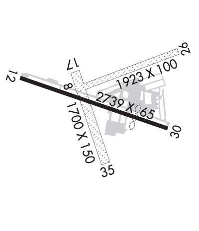
| Lat: N 4037.6 Long: W 07440.2 Elev: 106 Var: +13 Longest Runway: 2739 | ||
| CTAF: 123.0 | ||
| ||||||
| ||||||
|
| Rwy | Rwy | |||||||
| 1923x100 | 1923' | 1923x100 | 1923' | |||||
| 2739x65 | 2739' | 2739x65 | 2539' | |||||
| 1700x150 | 1700' | 1700x150 | 1700' | |||||
| Runway ID | Single Wheel | Double Wheel | Double Tandem Wheel | Dual Double Wheel |
| 08/26 | N/A | N/A | N/A | N/A |
| 12/30 | N/A | N/A | N/A | N/A |
| 17/35 | N/A | N/A | N/A | N/A |
| These numbers are Advisory and are not limits. The Airport Manager should have more accurate Weight Limits | ||||
 Airport Diagram might not be current. | |
| Facility Name: | SOMERSET |
| City Name: | SOMERVILLE |
| County: | SOMERSET |
| State abbrev: | NJ |
| State Name: | NEW JERSEY |
| Ownership: | PRIVATELY OWNED |
| Use: | OPEN TO THE PUBLIC |
| Owner's Name: | SOMERSET AIR SERVICE, INC |
| Address: | PO BOX 1007 |
| BEDMINSTER, NJ 07921 | |
| Owner's Phone: | 908-722-2444 |
| Manager's Name: | CHRIS WALKER, PRES. |
| Address: | PO BOX 1007 |
| BEDMINSTER, NJ 07921 | |
| Phone: | 908-722-2444 |
| FAA Region: | EASTERN |
| FAA Field Office: | HAR |
| Date | Sunrise | Sunset |
|---|---|---|
| 06/08/26 Monday | 5:28 | 20:28 |
| 06/09/26 Tuesday | 5:28 | 20:28 |
| 06/10/26 Wednesday | 5:27 | 20:29 |
| 06/11/26 Thursday | 5:27 | 20:29 |
| 06/12/26 Friday | 5:27 | 20:30 |
| 06/13/26 Saturday | 5:27 | 20:30 |
| 06/14/26 Sunday | 5:27 | 20:31 |
| 06/15/26 Monday | 5:27 | 20:31 |
| 06/16/26 Tuesday | 5:27 | 20:32 |
| 06/17/26 Wednesday | 5:27 | 20:32 |
| 06/18/26 Thursday | 5:27 | 20:32 |
| 06/19/26 Friday | 5:27 | 20:33 |
| 06/20/26 Saturday | 5:28 | 20:33 |
| 06/21/26 Sunday | 5:28 | 20:33 |
| Airport Attendance Schedule | 7 Days A Week 0800-1700; UNATTENDED THANKSGIVING, CHRISTMAS & NEW YEARS. |
| Airport Status | OPERATIONAL (This Status can change at any time - please check NOTAMS) |
| Airport Lighting Schedule | ACTVT REIL RWY 12 & 30; PAPI RWY 12 & 30; MIRL RWY 12/30 - 118.325. |
| Airport Storage Available | Tie Downs, Hanger |
| Extra Services Available | Air Ambulance, Avionics, Charter, Flight Instruction, Aircraft Rental, Aircraft Sales |
| Wind Indicator | YES - (lighted) |
| Control Tower | NO |
| CTAF Frequency | 123.000 |
| Unicom Frequency | 123.000 |
| Rotating Beacon Color | WG |
| Segmented Circle | NO |
| Landing Fee | NO |
| Airport Inspected | STATE - performed by STATE AERONAUTICAL PERSONNEL |
| Inspection Date | 04/21/2026 |
| Type of Fuel Available | Grade 100LL, JET A (freeze point -40C) |
| Airframe Repair Service | MAJOR |
| Power Plant Repair Service | MAJOR |
| Latitude | N4037.6 |
| Longitude | W07440.2 (ESTIMATED) |
| Arpt Elevation | 106ft (SURVEYED) |
| Magnetic Variation | 13W |
| 3 miles N | of SOMERVILLE |
| Traffic Pattern Altitude | |
| Sectional Chart | NEW YORK |
| Operations (Reported) | Yearly | Avg. Daily |
|---|---|---|
| General Aviation Transient | 0 | 0 |
| General Aviation Local | 0 | 0 |
| Air Taxi | 0 | 0 |
| Commerical | 0 | 0 |
| Commuter | 0 | 0 |
| Military | 0 | 0 |
| Aircraft based on Field | |
|---|---|
| General Aviation Singles | 0 |
| General Aviation Multi | 0 |
| Jet Aircraft | 0 |
| General Aviation Helicopters | 0 |
| Military Aircraft | 0 |
| Gliders | 0 |
| Ultralights | 0 |
| FSS on field | NO |
| FSS tie-in | MILLVILLE |
| FSS Phone | 1-800-WX-BRIEF |
| Who issues Notams | SMQ |
| Notam D service at airport | YES |
| ARTCC Name | NEW YORK |
| Airport Certification | |
| Aircraft Rescue & Firefighting Index | None |
| Airport of Entry | No |
| Custom Landing Rights | No |
| Joint Civil/Military | No |
| Military Landing rights | No |
| NATIONAL PLAN OF INTEGRATED AIRPORT SYSTEMS (NPIAS) |
| GRANT AGREEMENTS UNDER FAAP/ADAP/AIP |
| ASSURANCES PURSUANT TO TITLE VI, CIVIL RIGHTS ACT OF 1964 |
| FOR CD CTC NEWARK APCH AT 800-645-3206. |
| DEER AND BIRDS ON AND INVOF ARPT |
| NO TGL. |
| RWY 08/2 6 550 FT W END UNSUITABLE FOR TKOF OR LDG DUE TO UNEVEN SFC. |
Airport Communications & Frequencies:
| ||||||||||||||
| Runway: 08 | Runway: 26 | ||
| Mag heading: | 82° | Mag heading: | 262° |
| Rwy Slope: | .41% Up | Rwy Slope: | -.41% Down |
| Approach: | Approach: | ||
| Pattern: | Left Traffic | Pattern: | Right Traffic |
| Markings: | NONE | Markings: | NONE |
| Marking Condition: | Marking Condition: | ||
| Arresting Dev: | Arresting Dev: | ||
| Lat & Long: | N4037.6 W07440.3 | Lat. & Long.: | N4037.7 W07439.9 |
| Elev: | 95.0 ft. MSL | Elev: | 102.9 ft. MSL |
| TCH: | TCH: | ||
| Visual Glide Path: | Visual Glide Path: | ||
| Displaced Threshold: | No | Displaced Threshold: | No |
| Touchdown Zone: | YES | Touchdown Zone: | YES |
| Touchdown Elev.: | 106.2 feet | Touchdown Elev.: | 106.2 feet |
| Visual Glide Slope: | Visual Glide Slope: | ||
| RVR Equipment: | RVR Equipment: | ||
| RVV Equipment: | NO | RVV Equipment: | NO |
| Approach Lights: | Approach Lights: | ||
| REIL: | NO | REIL: | NO |
| Centerline Lights: | NO | Centerline Lights: | NO |
| Touchdown lights: | NO | Touchdown lights: | NO |
| Runway Category: | Runway with a Non-precision Approach | Runway Category: | Runway with a Visual Approach |
| Declared Distances: | Declared Distances: | ||
| Obstructions: | TREE | Obstructions: | TREE |
| Marked: | NOT Marked/Lighted | Marked: | NOT Marked/Lighted |
| Clearance slope: | 3:1 | Clearance slope: | |
| Obstruction height: | 51 feet AGL | Obstruction height: | 45 feet AGL |
| Dist. from runway: | 200 feet | Dist. from runway: | 10 feet |
| Centerline offset: | 50 left of centerline | Centerline offset: | 140 feet right of centerline |
| Comments: | Comments: |
| Runway: 12 | Runway: 30 | ||
| Mag heading: | 122° | Mag heading: | 302° |
| Rwy Slope: | .66% Up | Rwy Slope: | -.66% Down |
| Approach: | Approach: | ||
| Pattern: | Left Traffic | Pattern: | Left Traffic |
| Markings: | NONPRECISION INSTRUMENT | Markings: | NONPRECISION INSTRUMENT |
| Marking Condition: | GOOD | Marking Condition: | GOOD |
| Arresting Dev: | Arresting Dev: | ||
| Lat & Long: | N4037.6 W07440.5 | Lat. & Long.: | N4037.5 W07440.0 |
| Elev: | 83.9 ft. MSL | Elev: | 102.1 ft. MSL |
| TCH: | 30 ft. AGL | TCH: | 43 ft. AGL |
| Visual Glide Path: | 3.00 degrees | Visual Glide Path: | 4.00 degrees |
| Displaced Threshold: | No | Displaced Threshold: | 200 feet |
| Touchdown Zone: | YES | Touchdown Zone: | YES |
| Touchdown Elev.: | 104.3 feet | Touchdown Elev.: | 104.3 feet |
| Visual Glide Slope: | 2-Light PAPI on RIGHT side of Runway | Visual Glide Slope: | 2-Light PAPI on LEFT side of Runway |
| RVR Equipment: | RVR Equipment: | ||
| RVV Equipment: | NO | RVV Equipment: | NO |
| Approach Lights: | Approach Lights: | ||
| REIL: | YES | REIL: | YES |
| Centerline Lights: | NO | Centerline Lights: | NO |
| Touchdown lights: | NO | Touchdown lights: | NO |
| Runway Category: | Runway with a Non-precision Approach | Runway Category: | Runway with a Non-precision Approach |
| Declared Distances: | Declared Distances: | ||
| Obstructions: | TREES | Obstructions: | TREES |
| Marked: | NOT Marked/Lighted | Marked: | NOT Marked/Lighted |
| Clearance slope: | 7:1 | Clearance slope: | 9:1; APCH RATIO 15:1 TO DTHR. |
| Obstruction height: | 55 feet AGL | Obstruction height: | 65 feet AGL |
| Dist. from runway: | 587 feet | Dist. from runway: | 795 feet |
| Centerline offset: | 163 right of centerline | Centerline offset: | 280 feet left of centerline |
| Comments: | Comments: |
| Runway: 17 | Runway: 35 | ||
| Mag heading: | 174° | Mag heading: | 354° |
| Rwy Slope: | -.58% Down | Rwy Slope: | .58% Up |
| Approach: | Approach: | ||
| Pattern: | Left Traffic | Pattern: | Left Traffic |
| Markings: | NONE | Markings: | NONE |
| Marking Condition: | Marking Condition: | ||
| Arresting Dev: | Arresting Dev: | ||
| Lat & Long: | N4037.6 W07440.3 | Lat. & Long.: | N4037.4 W07440.2 |
| Elev: | 97.2 ft. MSL | Elev: | 87.4 ft. MSL |
| TCH: | TCH: | ||
| Visual Glide Path: | Visual Glide Path: | ||
| Displaced Threshold: | No | Displaced Threshold: | No |
| Touchdown Zone: | YES | Touchdown Zone: | YES |
| Touchdown Elev.: | 97.2 feet | Touchdown Elev.: | 97.2 feet |
| Visual Glide Slope: | Visual Glide Slope: | ||
| RVR Equipment: | RVR Equipment: | ||
| RVV Equipment: | NO | RVV Equipment: | NO |
| Approach Lights: | Approach Lights: | ||
| REIL: | NO | REIL: | NO |
| Centerline Lights: | NO | Centerline Lights: | NO |
| Touchdown lights: | NO | Touchdown lights: | NO |
| Runway Category: | Runway with a Visual Approach | Runway Category: | Runway with a Visual Approach |
| Declared Distances: | Declared Distances: | ||
| Obstructions: | TREES | Obstructions: | TREES |
| Marked: | NOT Marked/Lighted | Marked: | NOT Marked/Lighted |
| Clearance slope: | Clearance slope: | ||
| Obstruction height: | 65 feet AGL | Obstruction height: | 22 feet AGL |
| Dist. from runway: | 20 feet | Dist. from runway: | 10 feet |
| Centerline offset: | 120 right of centerline | Centerline offset: | 90 feet left of centerline |
| Comments: | Comments: |
Thanks for using FltPlan.com
all rights reserved © 1999-2026 by Flight Plan LLC
