
| SACRAMENTO INTL SACRAMENTO CA |
| |
| Lat: N 3841.7 Long: W 12135.4 Elev: 27 Var: -13 Longest Runway: 8605 | ||
| Clr Del: 121.1 Dept. ATIS: 126.75 Arr. ATIS: 126.75 Ground: 121.7 Tower: 125.7 | ||
| ||||||||||||||||||||||||||||||||||||||||||||
| ||||||||||||||||||||||||||||||||||||||||||||
| ||||||||||||||||||||||||||||||||||||||||||||
| ||||||||||||||||||||||||||||||||||||||||||||
| ||||||||||||||||||||||||||||||||||||||||||||
| FBOs at nearby airports who want your business: | |||||||||||
| |||||||||||
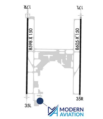
| Rwy | Rwy | |||||||
| 8605x150 | 8605' | 111.75 - 167° | 8605x150 | 8605' | ||||
| 8598x150 | 8598' | 111.10 - 167° | 8598x150 | 8598' | 111.10 - 347° | |||
| Runway ID | Single Wheel | Double Wheel | Double Tandem Wheel | Dual Double Wheel |
| 17L/35R | 120,000 | 250,000 | 513,000 | 1,033,000 |
| 17R/35L | 120,000 | 250,000 | 550,000 | 1,082,000 |
| These numbers are Advisory and are not limits. The Airport Manager should have more accurate Weight Limits | ||||
 Airport Diagram might not be current. | |
| Facility Name: | SACRAMENTO INTL |
| City Name: | SACRAMENTO |
| County: | SACRAMENTO |
| State abbrev: | CA |
| State Name: | CALIFORNIA |
| Ownership: | PUBLICLY OWNED |
| Use: | OPEN TO THE PUBLIC |
| Owner's Name: | COUNTY OF SACRAMENTO |
| Address: | 6900 AIRPORT BLVD |
| SACRAMENTO, CA 95837 | |
| Owner's Phone: | 916-929-5411 |
| Manager's Name: | SHERI THOMPSON-DUARTE; AIRSIDE OPS MGR 916-874-0713; 24HR OPS 916-806-5309. |
| Address: | 6900 AIRPORT BLVD |
| SACRAMENTO, CA 95837 | |
| Phone: | 916-874-0519 |
| FAA Region: | WESTERN-PACIFIC |
| FAA Field Office: | SFO |
| Date | Sunrise | Sunset |
|---|---|---|
| 06/08/26 Monday | 5:41 | 20:29 |
| 06/09/26 Tuesday | 5:41 | 20:30 |
| 06/10/26 Wednesday | 5:41 | 20:31 |
| 06/11/26 Thursday | 5:41 | 20:31 |
| 06/12/26 Friday | 5:41 | 20:31 |
| 06/13/26 Saturday | 5:41 | 20:32 |
| 06/14/26 Sunday | 5:41 | 20:32 |
| 06/15/26 Monday | 5:41 | 20:33 |
| 06/16/26 Tuesday | 5:41 | 20:33 |
| 06/17/26 Wednesday | 5:41 | 20:33 |
| 06/18/26 Thursday | 5:41 | 20:34 |
| 06/19/26 Friday | 5:41 | 20:34 |
| 06/20/26 Saturday | 5:42 | 20:34 |
| 06/21/26 Sunday | 5:42 | 20:34 |
| Airport Attendance Schedule | CONTINUOUS |
| Airport Status | OPERATIONAL (This Status can change at any time - please check NOTAMS) |
| Airport Lighting Schedule | |
| Airport Storage Available | Tie Downs |
| Extra Services Available | Air Freight, Cargo Handling, Charter |
| Wind Indicator | YES - (lighted) |
| Control Tower | YES |
| CTAF Frequency | |
| Unicom Frequency | 122.950 |
| Rotating Beacon Color | WG |
| Segmented Circle | NO |
| Landing Fee | NO |
| Airport Inspected | FEDERAL - performed by FAA AIRPORTS FIELD PERSONNEL |
| Inspection Date | 04/16/2025 |
| Type of Fuel Available | Grade 100LL, JET A (freeze point -40C) |
| Airframe Repair Service | MINOR |
| Power Plant Repair Service | MAJOR |
| Latitude | N3841.7 |
| Longitude | W12135.4 (ESTIMATED) |
| Arpt Elevation | 26ft (SURVEYED) |
| Magnetic Variation | 13E |
| 10 miles NW | of SACRAMENTO |
| Traffic Pattern Altitude | |
| Sectional Chart | SAN FRANCISCO |
| Operations (Reported) | Yearly | Avg. Daily |
|---|---|---|
| General Aviation Transient | 0 | 0 |
| General Aviation Local | 0 | 0 |
| Air Taxi | 0 | 0 |
| Commerical | 0 | 0 |
| Commuter | 0 | 0 |
| Military | 0 | 0 |
| Aircraft based on Field | |
|---|---|
| General Aviation Singles | 0 |
| General Aviation Multi | 0 |
| Jet Aircraft | 0 |
| General Aviation Helicopters | 0 |
| Military Aircraft | 0 |
| Gliders | 0 |
| Ultralights | 0 |
| FSS on field | NO |
| FSS tie-in | RANCHO MURIETA |
| FSS Phone | 1-800-WX-BRIEF |
| Who issues Notams | SMF |
| Notam D service at airport | YES |
| ARTCC Name | OAKLAND |
| Airport Certification | AIRPORT RECEIVING SCHEDULED AIR CARRIER SERVICE FROM CARRIERS CERTIFICATED BY THE CIVIL AERONAUTICS BOARD |
| Aircraft Rescue & Firefighting Index | AIRPORT HAS A CERTIFICATE UNDER CFR PART 139 |
| Airport of Entry | No |
| Custom Landing Rights | YES |
| Joint Civil/Military | No |
| Military Landing rights | YES |
| NATIONAL PLAN OF INTEGRATED AIRPORT SYSTEMS (NPIAS) |
| GRANT AGREEMENTS UNDER FAAP/ADAP/AIP |
| ASSURANCES PURSUANT TO TITLE VI, CIVIL RIGHTS ACT OF 1964 |
| BIRDS ON AND IN VICINITY OF ARPT. |
| TWY |
| TWY |
| MILITARY AIRCRAFT PARKING LIMITED. CONTACT ARPT OPNS IF PARKING IS REQUIRED (916) 806-5309. |
| PORTION OF TWY W 500 FT EAST OF TWY A TO 2100 FT EAST OF TWY A IS NOT VISIBLE FROM ATCT. |
| TWY Y4 RESTRICTED TO AIRCRAFT WITH A WINGSPAN OF LESS THAN 118 FT (GROUP III). |
| UNPAVED SFC NORTH OF TWY P AND EAST OF TWY A AND SOUTH OF CARGO 1 RAMP CLSD TO HEL. |
| ACFT MUST PUSH BACK TAIL TO THE NORTH FROM TRML GATES A1, A3 AND A5. |
| WEST RAMP SPOTS 63W, 65W, 66 & F1 RSTRD TO TOW IN AND TOW OUT ONLY FROM TXL B2. WHEN PUSHING BACK FOR DEP FROM WEST RAMP SPOTS 63W, 65W, 66 & F1 EACH ACFT IS TO PUSH BACK ONTO TXL B2 AND PULL FWD TO THE ENG START LINE PRIOR TO STARTING ENGS. ADG V ACFT PRKD ON SPOT 66 IS TO PUSH ONTO TWY A AFTER RCVG APVL FROM ATC. |
| TWY B1 RSTRD TO ACFT WITH A WINGSPAN OF LESS THAN 118 FT (GROUP III). |
| NOISE SENSITIVE AREAS W OF ARPT ON SAC RIVER. LCL TURN DISCOURAGED FOR JET ACFT. WHEN CONDUCTING IFR APCH IN VFR CONDITIONS EXECUTE MISSED APCH AT DEP END OF RYS. PLAN VFR PATTERNS TO E. USE MIN POWER SETTINGS. |
| ALL ACFT CTC ATC GND CTL PRIOR TO MOVEMENT ON RAMP. |
| CROP DUSTERS OPER INVOF ARPT AT OR BELOW 200 FT AGL. |
| RWY 17L/ 35RPCR VALUE: 900/R/B/W/T |
| RWY 17R/ 35LPCR VALUE: 840/R/A/W/T |
Airport Communications & Frequencies:
| |||||||||||||||||||||||||||||||||||||||||||||||||||||||||||
| Runway: 17L | Runway: 35R | ||
| Mag heading: | 168° | Mag heading: | 348° |
| Rwy Slope: | -.06% Down | Rwy Slope: | .06% Up |
| Approach: | ILS/DME | Approach: | |
| Pattern: | Left Traffic | Pattern: | Right Traffic |
| Markings: | PRECISION INSTRUMENT | Markings: | NONPRECISION INSTRUMENT |
| Marking Condition: | GOOD | Marking Condition: | GOOD |
| Arresting Dev: | Arresting Dev: | ||
| Lat & Long: | N3842.4 W12134.8 | Lat. & Long.: | N3841.0 W12134.8 |
| Elev: | 26.9 ft. MSL | Elev: | 22.1 ft. MSL |
| TCH: | 64 ft. AGL | TCH: | 64 ft. AGL |
| Visual Glide Path: | 3.00 degrees | Visual Glide Path: | 3.00 degrees |
| Displaced Threshold: | No | Displaced Threshold: | No |
| Touchdown Zone: | YES | Touchdown Zone: | YES |
| Touchdown Elev.: | 26.9 feet | Touchdown Elev.: | 23.8 feet |
| Visual Glide Slope: | 4-Light PAPI on LEFT side of Runway | Visual Glide Slope: | 4-Light PAPI on LEFT side of Runway |
| RVR Equipment: | TOUCHDOWN-ROLLOUT | RVR Equipment: | TOUCHDOWN-ROLLOUT |
| RVV Equipment: | NO | RVV Equipment: | NO |
| Approach Lights: | MALSR - 1,400 foot medium intensity approach lighting system with runway alignment indicator lights | Approach Lights: | |
| REIL: | NO | REIL: | NO |
| Centerline Lights: | YES | Centerline Lights: | YES |
| Touchdown lights: | YES | Touchdown lights: | NO |
| Runway Category: | Precision Instrument Runway | Runway Category: | Runway with a Non-precision Approach having visibility minimums greater than 3/4 mile |
| Declared Distances: | TORA:8605' TODA:8605' ASDA:8605' LDA:8605' | Declared Distances: | TORA:8605' TODA:8605' ASDA:8605' LDA:8605' |
| Runway: 17R | Runway: 35L | ||
| Mag heading: | 168° | Mag heading: | 348° |
| Rwy Slope: | -.03% Down | Rwy Slope: | .03% Up |
| Approach: | ILS/DME | Approach: | ILS/DME |
| Pattern: | Right Traffic | Pattern: | Left Traffic |
| Markings: | PRECISION INSTRUMENT | Markings: | PRECISION INSTRUMENT |
| Marking Condition: | GOOD | Marking Condition: | GOOD |
| Arresting Dev: | Arresting Dev: | ||
| Lat & Long: | N3842.4 W12136.1 | Lat. & Long.: | N3841.0 W12136.1 |
| Elev: | 24.8 ft. MSL | Elev: | 22.5 ft. MSL |
| TCH: | 72 ft. AGL | TCH: | 76 ft. AGL |
| Visual Glide Path: | 3.00 degrees | Visual Glide Path: | 3.00 degrees |
| Displaced Threshold: | No | Displaced Threshold: | No |
| Touchdown Zone: | YES | Touchdown Zone: | YES |
| Touchdown Elev.: | 25.3 feet | Touchdown Elev.: | 23.9 feet |
| Visual Glide Slope: | 4-Light PAPI on RIGHT side of Runway | Visual Glide Slope: | 4-Light PAPI on RIGHT side of Runway |
| RVR Equipment: | TOUCHDOWN-MIDFIELD-ROLLOUT | RVR Equipment: | TOUCHDOWN-MIDFIELD-ROLLOUT |
| RVV Equipment: | NO | RVV Equipment: | NO |
| Approach Lights: | ALSF2 - standard 2,400 foot high intensity approach lighting system with sequenced flashers, Category II or III; ALSF2 OPRS AS SSALR TILL WX GOES BLW VFR. | Approach Lights: | MALSR - 1,400 foot medium intensity approach lighting system with runway alignment indicator lights |
| REIL: | NO | REIL: | NO |
| Centerline Lights: | YES | Centerline Lights: | YES |
| Touchdown lights: | YES | Touchdown lights: | NO |
| Runway Category: | Precision Instrument Runway | Runway Category: | Precision Instrument Runway |
| Declared Distances: | TORA:8598' TODA:8598' ASDA:8598' LDA:8598' | Declared Distances: | TORA:8598' TODA:8598' ASDA:8598' LDA:8598' |
Thanks for using FltPlan.com
all rights reserved © 1999-2026 by Flight Plan LLC