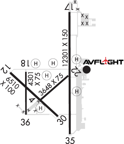
Runway Identification: 04/22Length: 3648 ft
Width: 75 ft
Surface: ASPHALT-GOOD CONDITION
Edge lights: Weight: PCN 5 /F/C/Y/U
| | Runway: 04 | | Runway: 22 |
| Mag heading: | 42° | Mag heading: | 222° |
| Rwy Slope: | -.40% Down | Rwy Slope: | .40% Up |
| Approach: | | Approach: | |
| Pattern: | Left Traffic | Pattern: | Left Traffic |
| Markings: | BASIC | Markings: | BASIC |
| Marking Condition: | FAIR | Marking Condition: | FAIR |
| Arresting Dev: | | Arresting Dev: | |
| Lat & Long: | N3847.2 W09739.4 | Lat. & Long.: | N3847.6 W09738.8 |
| Elev: | 1270.7 ft. MSL | Elev: | 1256.0 ft. MSL |
| TCH: | | TCH: | |
| Visual Glide Path: | | Visual Glide Path: | |
| Displaced Threshold: | No | Displaced Threshold: | No |
| Touchdown Zone: | YES | Touchdown Zone: | YES |
| Touchdown Elev.: | 1270.7 feet | Touchdown Elev.: | 1267.2 feet |
| Visual Glide Slope: | | Visual Glide Slope: | |
| RVR Equipment: | | RVR Equipment: | |
| RVV Equipment: | NO | RVV Equipment: | NO |
| Approach Lights: | | Approach Lights: | |
| REIL: | NO | REIL: | NO |
| Centerline Lights: | NO | Centerline Lights: | NO |
| Touchdown lights: | NO | Touchdown lights: | NO |
| Runway Category: | Runway with a Visual Approach | Runway Category: | Runway with a Visual Approach |
| Declared Distances: | TORA:3648' TODA:3648' ASDA:3648' LDA:3648' | Declared Distances: | TORA:3648' TODA:3648' ASDA:3648' LDA:3648' |
| Obstructions: | | Obstructions: | BLDG |
| Marked: | | Marked: | LIGHTED |
| Clearance slope: | 50:1 | Clearance slope: | 29:1 |
| Obstruction height: | | Obstruction height: | 46 feet AGL |
| Dist. from runway: | | Dist. from runway: | 1550 feet |
| Centerline offset: | | Centerline offset: | 200 feet left of centerline |
| Comments: | | Comments: | |
Runway Identification: 12/30Length: 6510 ft
Width: 100 ft
Surface: ASPHALT
Edge lights: Medium IntensityWeight: PCN 23 /R/C/X/U
| | Runway: 12 | | Runway: 30 |
| Mag heading: | 125° | Mag heading: | 305° |
| Rwy Slope: | .21% Up | Rwy Slope: | -.21% Down |
| Approach: | | Approach: | |
| Pattern: | Left Traffic | Pattern: | Left Traffic |
| Markings: | NONPRECISION INSTRUMENT | Markings: | NONPRECISION INSTRUMENT |
| Marking Condition: | GOOD | Marking Condition: | GOOD |
| Arresting Dev: | | Arresting Dev: | |
| Lat & Long: | N3847.6 W09740.0 | Lat. & Long.: | N3846.9 W09739.0 |
| Elev: | 1258.3 ft. MSL | Elev: | 1271.7 ft. MSL |
| TCH: | 45 ft. AGL | TCH: | 45 ft. AGL |
| Visual Glide Path: | 3.00 degrees | Visual Glide Path: | 3.00 degrees |
| Displaced Threshold: | No | Displaced Threshold: | No |
| Touchdown Zone: | YES | Touchdown Zone: | YES |
| Touchdown Elev.: | 1267.9 feet | Touchdown Elev.: | 1272.5 feet |
| Visual Glide Slope: | 4-Light PAPI on LEFT side of Runway | Visual Glide Slope: | 4-Light PAPI on LEFT side of Runway |
| RVR Equipment: | | RVR Equipment: | |
| RVV Equipment: | NO | RVV Equipment: | NO |
| Approach Lights: | | Approach Lights: | |
| REIL: | NO | REIL: | NO |
| Centerline Lights: | NO | Centerline Lights: | NO |
| Touchdown lights: | NO | Touchdown lights: | NO |
| Runway Category: | Runway with a Non-precision Approach having visibility minimums greater than 3/4 mile | Runway Category: | Runway with a Non-precision Approach having visibility minimums greater than 3/4 mile |
| Declared Distances: | TORA:6510' TODA:6510' ASDA:6510' LDA:6510' | Declared Distances: | TORA:6510' TODA:6510' ASDA:6510' LDA:6510' |
Runway Identification: 17/35Length: 12301 ft
Width: 150 ft
Surface: CONCRETE ASPHALT-GOOD CONDITION
Edge lights: High IntensityTreatment: NONE
Weight: PCN 75 /R/C/W/U
| | Runway: 17 | | Runway: 35 |
| Mag heading: | 173° | Mag heading: | 353° |
| Rwy Slope: | .21% Up | Rwy Slope: | -.21% Down |
| Approach: | | Approach: | ILS |
| Pattern: | Left Traffic | Pattern: | Left Traffic |
| Markings: | PRECISION INSTRUMENT | Markings: | PRECISION INSTRUMENT |
| Marking Condition: | GOOD | Marking Condition: | GOOD |
| Arresting Dev: | | Arresting Dev: | |
| Lat & Long: | N3848.6 W09738.8 | Lat. & Long.: | N3846.6 W09738.8 |
| Elev: | 1245.8 ft. MSL | Elev: | 1271.1 ft. MSL |
| TCH: | 52 ft. AGL | TCH: | 48 ft. AGL |
| Visual Glide Path: | 3.00 degrees | Visual Glide Path: | 3.00 degrees |
| Displaced Threshold: | No | Displaced Threshold: | No |
| Touchdown Zone: | YES | Touchdown Zone: | YES |
| Touchdown Elev.: | 1247.3 feet | Touchdown Elev.: | 1271.1 feet |
| Visual Glide Slope: | 4-Light PAPI on LEFT side of Runway | Visual Glide Slope: | 4-Light PAPI on RIGHT side of Runway |
| RVR Equipment: | | RVR Equipment: | |
| RVV Equipment: | NO | RVV Equipment: | NO |
| Approach Lights: | MALS - 1,400 foot medium intensity approach lighting system | Approach Lights: | MALSR - 1,400 foot medium intensity approach lighting system with runway alignment indicator lights |
| REIL: | NO | REIL: | NO |
| Centerline Lights: | NO | Centerline Lights: | NO |
| Touchdown lights: | NO | Touchdown lights: | NO |
| Runway Category: | D | Runway Category: | Precision Instrument Runway |
| Declared Distances: | TORA:12300' TODA:12300' ASDA:12300' LDA:12300' | Declared Distances: | TORA:12300' TODA:12300' ASDA:12300' LDA:12300' |
| Obstructions: | | Obstructions: | GND |
| Marked: | | Marked: | NOT Marked/Lighted |
| Clearance slope: | 50:1 | Clearance slope: | 39:1 |
| Obstruction height: | | Obstruction height: | 30 feet AGL |
| Dist. from runway: | | Dist. from runway: | 1375 feet |
| Centerline offset: | | Centerline offset: | 500 feet left of centerline |
| Comments: | | Comments: | |
Runway Identification: 18/36Length: 4301 ft
Width: 75 ft
Surface: ASPHALT
Edge lights: Weight: PCN 11 /F/C/Y/U
| | Runway: 18 | | Runway: 36 |
| Mag heading: | 173° | Mag heading: | 353° |
| Rwy Slope: | .79% Up | Rwy Slope: | -.79% Down |
| Approach: | | Approach: | |
| Pattern: | Left Traffic | Pattern: | Left Traffic |
| Markings: | NONPRECISION INSTRUMENT | Markings: | NONPRECISION INSTRUMENT |
| Marking Condition: | GOOD | Marking Condition: | GOOD |
| Arresting Dev: | | Arresting Dev: | |
| Lat & Long: | N3847.6 W09739.7 | Lat. & Long.: | N3846.9 W09739.7 |
| Elev: | 1253.7 ft. MSL | Elev: | 1287.8 ft. MSL |
| TCH: | | TCH: | |
| Visual Glide Path: | | Visual Glide Path: | |
| Displaced Threshold: | No | Displaced Threshold: | No |
| Touchdown Zone: | YES | Touchdown Zone: | YES |
| Touchdown Elev.: | 1273.8 feet | Touchdown Elev.: | 1288.0 feet |
| Visual Glide Slope: | | Visual Glide Slope: | |
| RVR Equipment: | | RVR Equipment: | |
| RVV Equipment: | NO | RVV Equipment: | NO |
| Approach Lights: | | Approach Lights: | |
| REIL: | NO | REIL: | NO |
| Centerline Lights: | NO | Centerline Lights: | NO |
| Touchdown lights: | NO | Touchdown lights: | NO |
| Runway Category: | Runway with a Visual Approach | Runway Category: | Runway with a Visual Approach |
| Declared Distances: | TORA:4300' TODA:4300' ASDA:4300' LDA:4300' | Declared Distances: | TORA:4300' TODA:4300' ASDA:4300' LDA:4300' |
Runway Identification: H1 HELIPADLength: 57 ft
Width: 57 ft
Surface: CONCRETE-GOOD CONDITION
Edge lights:
Runway Identification: H2 HELIPADLength: 29 ft
Width: 28 ft
Surface: ASPHALT-GOOD CONDITION
Edge lights:
Runway Identification: H3 HELIPADLength: 30 ft
Width: 30 ft
Surface: CONCRETE-GOOD CONDITION
Edge lights:
Runway Identification: H4 HELIPADLength: 57 ft
Width: 43 ft
Surface: ASPHALT-GOOD CONDITION
Edge lights:
Runway Identification: H5 HELIPADLength: 57 ft
Width: 57 ft
Surface: CONCRETE-GOOD CONDITION
Edge lights:
Runway Identification: H6 HELIPADLength: 29 ft
Width: 29 ft
Surface: CONCRETE-GOOD CONDITION
Edge lights: