
| LOS ALAMITOS AAF LOS ALAMITOS CA |
| |
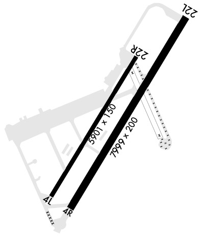
| Lat: N 3347.4 Long: W 11803.1 Elev: 36 Var: -12 Longest Runway: 7999 | ||
| Dept. ATIS: 118.87 Arr. ATIS: 118.87 Ground: 126.95 Tower: 123.85 | ||
| ||||||
| ||||||
|
| Rwy | Rwy | |||||||
| 5901x150 | 5901' | 5901x150 | 5901' | |||||
| 7999x200 | 7999' | 7999x200 | 7999' | |||||
| Runway ID | Single Wheel | Double Wheel | Double Tandem Wheel | Dual Double Wheel |
| 04L/22R | N/A | N/A | N/A | N/A |
| 04R/22L | N/A | N/A | N/A | N/A |
| These numbers are Advisory and are not limits. The Airport Manager should have more accurate Weight Limits | ||||
 Airport Diagram might not be current. | |
| Facility Name: | LOS ALAMITOS AAF; (JOINT FORCES TRAINING BASE JFTB) |
| City Name: | LOS ALAMITOS |
| County: | ORANGE |
| State abbrev: | CA |
| State Name: | CALIFORNIA |
| Ownership: | ARMY OWNED |
| Use: | PRIVATE |
| Owner's Name: | US ARMY |
| Address: | AASF, CAARNG, 4612 DOOLITTLE AVE |
| LOS ALAMITOS, CA 90720 | |
| Owner's Phone: | 562-795-2571 |
| Manager's Name: | BASE OPS; AIRFIELD OPERATIONS: C562-795-2571/2561 |
| Address: | |
| LOS ALAMITOS, CA 90720 | |
| Phone: | 562-795-1351 |
| FAA Region: | WESTERN-PACIFIC |
| FAA Field Office: | LAX |
| Date | Sunrise | Sunset |
|---|---|---|
| 09/24/21 Friday | 6:42 | 18:46 |
| 09/25/21 Saturday | 6:42 | 18:45 |
| 09/26/21 Sunday | 6:43 | 18:44 |
| 09/27/21 Monday | 6:44 | 18:42 |
| 09/28/21 Tuesday | 6:44 | 18:41 |
| 09/29/21 Wednesday | 6:45 | 18:39 |
| 09/30/21 Thursday | 6:46 | 18:38 |
| 10/01/21 Friday | 6:46 | 18:37 |
| 10/02/21 Saturday | 6:47 | 18:35 |
| 10/03/21 Sunday | 6:48 | 18:34 |
| 10/04/21 Monday | 6:49 | 18:33 |
| 10/05/21 Tuesday | 6:49 | 18:31 |
| 10/06/21 Wednesday | 6:50 | 18:30 |
| 10/07/21 Thursday | 6:51 | 18:29 |
| Airport Attendance Schedule | TUE-THU 1400-0600Z++, FRI-MON 1400-2300Z++; CLSD ALL FED HOL. EXP CLOSURE OR REDUCED SVC PER NOTAM. RSTD: PPR CTC AFLD OPS, RCMD UNITS ASK FOR CURRENT CPBLTY WHEN REQG PPR DSN 972-2571, C562-795-2571; NG.CA.CAARNG.MBX.KSLIOPERATIONS@MAIL.MIL FOR PPR REQ FORM. |
| Airport Status | OPERATIONAL (This Status can change at any time - please check NOTAMS) |
| Airport Lighting Schedule | SS-SR |
| Airport Storage Available | NONE |
| Extra Services Available | NONE |
| Wind Indicator | NONE |
| Control Tower | YES |
| CTAF Frequency | 123.850; USE 251.15 WHEN LOS ALAMITOS TWR CLSD. |
| Unicom Frequency | |
| Rotating Beacon Color | SPLIT-CLEAR-GREEN (LIGHTED MILITARY AIRPORT) |
| Segmented Circle | NO |
| Landing Fee |
| Airport Inspected | No Inspection Data Available performed by the OWNER |
| Inspection Date | Unknown |
| Type of Fuel Available | JET A-1 (icing inhibitor, freeze point -50C), JET B (wide-cut turbine fuel, icing inhibitor, freeze point -50C)J8; -J8NATO F24 AVBL. |
| Airframe Repair Service | None |
| Power Plant Repair Service | None |
| Latitude | N3347.4 |
| Longitude | W11803.1 (ESTIMATED) |
| Arpt Elevation | 35ft (SURVEYED) |
| Magnetic Variation | 12E |
| 1 miles SE | of LOS ALAMITOS |
| Traffic Pattern Altitude | |
| Sectional Chart | LOS ANGELES |
| Operations (Reported) | Yearly | Avg. Daily |
|---|---|---|
| General Aviation Transient | 0 | 0 |
| General Aviation Local | 0 | 0 |
| Air Taxi | 0 | 0 |
| Commerical | 0 | 0 |
| Commuter | 0 | 0 |
| Military | 0 | 0 |
| Aircraft based on Field | |
|---|---|
| General Aviation Singles | 0 |
| General Aviation Multi | 0 |
| Jet Aircraft | 0 |
| General Aviation Helicopters | 0 |
| Military Aircraft | 0 |
| Gliders | 0 |
| Ultralights | 0 |
| FSS on field | NO |
| FSS tie-in | HAWTHORNE |
| FSS Phone | 1-800-WX-BRIEF |
| Who issues Notams | SLI |
| Notam D service at airport | YES |
| ARTCC Name | LOS ANGELES |
| Airport Certification | |
| Aircraft Rescue & Firefighting Index | None |
| Airport of Entry | No |
| Custom Landing Rights | No |
| Joint Civil/Military | No |
| Military Landing rights | No |
| RWY-LGTS: RWY 22L - SF. |
| MISC - WINDS ARE ACCURATE TO WITHIN PLUS OR MINUS 4 KNOTS. |
| MISC: TO EXCEED WT BRG CAP CTC AFLD OPS. SEE FLIP AP/1 RTE AND AREA RSTD AND SUPPLEMENT ARPT |
| ARNG AASF OPS- OPR 1530-2330Z++ MON-FRI; EXC HOL. DSN 972-2006, C562-795-2006. HTTP://WWW.CALGUARD.CA.GOV/AASF1. |
| RSTD: FOR SPECIAL AFTER HRS LNDG AND AFLD LIGHTING REQUESTS FOR ACFT WEIGHING UNDER 14,500 LBS, CALL AFLD OPS AT 562-795-2571. |
| SERVICE: TRAN ALERT - FUEL OPR 1500-2200Z++ MON-FRI, CLSD SAT-SUN, CLSD ALL FED HOL. EXP CLOSURE OR RDCD SVC PER NOTAM. NO PRIORITY BASIS. EXP SVC DELAYS IF HEAVY ACFT ARE UTILIZING LAAAF. NO ACFT LAV SVC OR BELT LOAD CTC AIRSERV AT KLGB 866-247-7378 OR 562-429-8062. LTD TRAN SVC. NO SHUTTLE SVC AVBL. |
| CLASSIFIED STOR FOR TSNT AIRCREW UNAVBL AT AFLD MGMT OPS; CTC BASE SECFOR DSN 972-2100, C562-795-2100. |
| AIRCREWS UTILIZING LAAAF MUST ADVS THEIR DEP TO LOCAL FSS TO INCL KSLIYXYX AS AN ADDRESSEE ON THE ORIG DD 175/DD 1801 FLT PLAN AND ON ANY CHG, DELAY, DEP AND CNL MSG. |
| ALL TRAN AIRCREWS MUST RPT TO AFLD OPS. HIGH VIS EVENTS (VIP CODE 7 AND ABV) ARE RQRD TO NTFY AFLD OPS 30 MIN PRIOR TO ARR DUE TO POST HQ COORD. |
| RWY-17/35 CLSD (2500X150 ASP). |
| MISC: AFLD SIGNS NSTD. RWY 04R/22L THLD BARS NSTD. ALL RWY MARKINGS NSTD. TWY AND PRKG LINES NSTD AND NOT VIS IN DARKNESS OR INCLEMENT WX. |
| MISC: WILDLIFE HAZ EXISTS; RQRS INCRD VIGILANCE BY ALL AGENCIES AND SUPVRS AND CTN BY AIRCREWS. BASH/WASH COND ANNOUNCED ON ATIS. PILOTS SHOULD RPRT ALL LARGE BIRD AND MAMMAL SIGHTINGS TO TWR OR AFLD OPS. |
| FOR CD WHEN ATCT CLSD CTC SOCAL APCH AT 800-448-3724. |
| JASU - 1(TMD150CIII) 1(AGPU). |
| NS ABTMT - PRO IN EFF. ALL DEP RQR BRIEFINGS. |
| RWY 04R/ 22LHIRL ELEV 1 FT AND LCTD 5 FT FROM EDGE OF RWY. |
Airport Communications & Frequencies:
| |||||||||||||||||||||||||||||
| Runway: 04L | Runway: 22R | ||
| Mag heading: | N/A | Mag heading: | N/A |
| Rwy Slope: | .12% Up | Rwy Slope: | -.12% Down |
| Approach: | Approach: | ||
| Pattern: | Left Traffic | Pattern: | Left Traffic |
| Markings: | Markings: | ||
| Marking Condition: | Marking Condition: | ||
| Arresting Dev: | Arresting Dev: | ||
| Lat & Long: | N3347.1 W11803.7 | Lat. & Long.: | N3347.7 W11802.8 |
| Elev: | 20.0 ft. MSL | Elev: | 26.9 ft. MSL |
| TCH: | TCH: | ||
| Visual Glide Path: | Visual Glide Path: | ||
| Displaced Threshold: | No | Displaced Threshold: | No |
| Touchdown Zone: | YES | Touchdown Zone: | YES |
| Touchdown Elev.: | 24.6 feet | Touchdown Elev.: | 27.9 feet |
| Visual Glide Slope: | Visual Glide Slope: | ||
| RVR Equipment: | RVR Equipment: | ||
| RVV Equipment: | NO | RVV Equipment: | NO |
| Approach Lights: | Approach Lights: | ||
| REIL: | NO | REIL: | NO |
| Centerline Lights: | NO | Centerline Lights: | NO |
| Touchdown lights: | NO | Touchdown lights: | NO |
| Runway Category: | Runway Category: | ||
| Declared Distances: | Declared Distances: |
| Runway: 04R | Runway: 22L | ||
| Mag heading: | N/A | Mag heading: | N/A |
| Rwy Slope: | .18% Up | Rwy Slope: | -.18% Down |
| Approach: | Approach: | ||
| Pattern: | Left Traffic | Pattern: | Left Traffic |
| Markings: | Markings: | ||
| Marking Condition: | Marking Condition: | ||
| Arresting Dev: | Arresting Dev: | ||
| Lat & Long: | N3347.0 W11803.6 | Lat. & Long.: | N3347.8 W11802.3 |
| Elev: | 21.2 ft. MSL | Elev: | 35.5 ft. MSL |
| TCH: | TCH: | 75 ft. AGL | |
| Visual Glide Path: | Visual Glide Path: | 3.00 degrees | |
| Displaced Threshold: | No | Displaced Threshold: | No |
| Touchdown Zone: | YES | Touchdown Zone: | YES |
| Touchdown Elev.: | 26.0 feet | Touchdown Elev.: | 35.5 feet |
| Visual Glide Slope: | Visual Glide Slope: | 4-Light PAPI on LEFT side of Runway | |
| RVR Equipment: | RVR Equipment: | ||
| RVV Equipment: | NO | RVV Equipment: | NO |
| Approach Lights: | Approach Lights: | SALSF | |
| REIL: | NO | REIL: | YES |
| Centerline Lights: | YES | Centerline Lights: | YES |
| Touchdown lights: | NO | Touchdown lights: | NO |
| Runway Category: | Runway Category: | ||
| Declared Distances: | Declared Distances: |
Thanks for using FltPlan.com
all rights reserved © 1999-2021 by Flight Plan LLC
