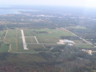
| CHEBOYGAN COUNTY CHEBOYGAN MI |
| |
| Lat: N 4539.2 Long: W 08431.2 Elev: 640 Var: +07 Longest Runway: 4004 | ||
| AWOS: 118.17 CTAF: 122.8 | ||
| |||||||||||||||||||||||||||||||
| |||||||||||||||||||||||||||||||
| |||||||||||||||||||||||||||||||
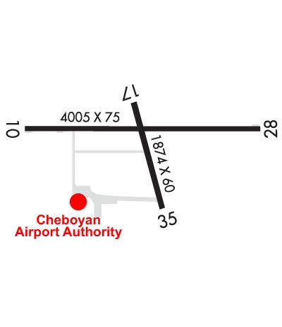
| Rwy | Rwy | |||||||
| 4004x75 | 4004' | 4004x75 | 4004' | |||||
| 1874x60 | 1874' | 1874x60 | 1874' | |||||
| Runway ID | Single Wheel | Double Wheel | Double Tandem Wheel | Dual Double Wheel |
| 10/28 | 23,000 | 34,000 | 60,000 | N/A |
| 17/35 | N/A | N/A | N/A | N/A |
| These numbers are Advisory and are not limits. The Airport Manager should have more accurate Weight Limits | ||||
 Airport Diagram might not be current. | |
| Facility Name: | CHEBOYGAN COUNTY |
| City Name: | CHEBOYGAN |
| County: | CHEBOYGAN |
| State abbrev: | MI |
| State Name: | MICHIGAN |
| Ownership: | PUBLICLY OWNED |
| Use: | OPEN TO THE PUBLIC |
| Owner's Name: | CHEBOYGAN AIRPORT AUTHORITY |
| Address: | 1520 LEVERING RD |
| CHEBOYGAN, MI 49721-9381 | |
| Owner's Phone: | 231-627-5571 |
| Manager's Name: | MICHAEL JERMEAY |
| Address: | 1520 LEVERING RD |
| CHEBOYGAN, MI 49721-9381 | |
| Phone: | 231-627-5571; CELL 989-464-6887. |
| FAA Region: | GREAT LAKES |
| FAA Field Office: | DET |
| Date | Sunrise | Sunset |
|---|---|---|
| 06/07/26 Sunday | 5:49 | 21:25 |
| 06/08/26 Monday | 5:49 | 21:25 |
| 06/09/26 Tuesday | 5:49 | 21:26 |
| 06/10/26 Wednesday | 5:49 | 21:27 |
| 06/11/26 Thursday | 5:48 | 21:27 |
| 06/12/26 Friday | 5:48 | 21:28 |
| 06/13/26 Saturday | 5:48 | 21:28 |
| 06/14/26 Sunday | 5:48 | 21:29 |
| 06/15/26 Monday | 5:48 | 21:29 |
| 06/16/26 Tuesday | 5:48 | 21:30 |
| 06/17/26 Wednesday | 5:48 | 21:30 |
| 06/18/26 Thursday | 5:48 | 21:30 |
| 06/19/26 Friday | 5:48 | 21:31 |
| 06/20/26 Saturday | 5:48 | 21:31 |
| Airport Attendance Schedule | SAT-SUN ON-CALL, MON-FRI 0800-1600; UNATNDD CHRISTMAS, EASTER, & THANKSGIVING OR BY ARNGMT. |
| Airport Status | OPERATIONAL (This Status can change at any time - please check NOTAMS) |
| Airport Lighting Schedule | ACTVT REIL RWY 10 & 28; PAPI RWY 10 & 28; MIRL RWY 10/28 & 17/35 - CTAF. |
| Airport Storage Available | NONE |
| Extra Services Available | Flight Instruction, Aircraft Rental |
| Wind Indicator | YES - (lighted) |
| Control Tower | NO |
| CTAF Frequency | 122.800 |
| Unicom Frequency | 122.800 |
| Rotating Beacon Color | WG |
| Segmented Circle | YES |
| Landing Fee | NO |
| Airport Inspected | STATE - performed by STATE AERONAUTICAL PERSONNEL |
| Inspection Date | 09/17/2025 |
| Type of Fuel Available | Grade 100LL, JET A; -10100LL AVBL H24 SELF SVC. FOR JET A AFT HRS CALL 989-464-6887 SUBJ CALL-IN FEE. |
| Airframe Repair Service | MAJOR |
| Power Plant Repair Service | MAJOR |
| Latitude | N4539.2 |
| Longitude | W08431.2 (ESTIMATED) |
| Arpt Elevation | 639ft (SURVEYED) |
| Magnetic Variation | 07W |
| 2 miles W | of CHEBOYGAN |
| Traffic Pattern Altitude | |
| Sectional Chart | LAKE HURON |
| Operations (Reported) | Yearly | Avg. Daily |
|---|---|---|
| General Aviation Transient | 0 | 0 |
| General Aviation Local | 0 | 0 |
| Air Taxi | 0 | 0 |
| Commerical | 0 | 0 |
| Commuter | 0 | 0 |
| Military | 0 | 0 |
| Aircraft based on Field | |
|---|---|
| General Aviation Singles | 0 |
| General Aviation Multi | 0 |
| Jet Aircraft | 0 |
| General Aviation Helicopters | 0 |
| Military Aircraft | 0 |
| Gliders | 0 |
| Ultralights | 0 |
| FSS on field | NO |
| FSS tie-in | LANSING |
| FSS Phone | 1-800-WX-BRIEF |
| Who issues Notams | SLH |
| Notam D service at airport | YES |
| ARTCC Name | MINNEAPOLIS |
| Airport Certification | |
| Aircraft Rescue & Firefighting Index | None |
| Airport of Entry | No |
| Custom Landing Rights | No |
| Joint Civil/Military | No |
| Military Landing rights | YES |
| NATIONAL PLAN OF INTEGRATED AIRPORT SYSTEMS (NPIAS) |
| GRANT AGREEMENTS UNDER FAAP/ADAP/AIP |
| ASSURANCES PURSUANT TO TITLE VI, CIVIL RIGHTS ACT OF 1964 |
| DEER, BIRDS, & WILDLIFE ON & INVOF ARPT. |
| AFT HRS TRML BLDG ACES: PRESS 5, THEN 3 & 2 SIMUL, THEN 1. |
| FOR CD CTC MINNEAPOLIS ARTCC AT 651-463-5588. |
Airport Communications & Frequencies:
| |||||||||
| Runway: 10 | Runway: 28 | ||
| Mag heading: | 97° | Mag heading: | 277° |
| Rwy Slope: | -.31% Down | Rwy Slope: | .31% Up |
| Approach: | Approach: | ||
| Pattern: | Left Traffic | Pattern: | Left Traffic |
| Markings: | NONPRECISION INSTRUMENT | Markings: | NONPRECISION INSTRUMENT |
| Marking Condition: | GOOD | Marking Condition: | GOOD |
| Arresting Dev: | Arresting Dev: | ||
| Lat & Long: | N4539.3 W08431.6 | Lat. & Long.: | N4539.3 W08430.7 |
| Elev: | 639.5 ft. MSL | Elev: | 626.9 ft. MSL |
| TCH: | 40 ft. AGL | TCH: | 25 ft. AGL |
| Visual Glide Path: | 4.00 degrees | Visual Glide Path: | 4.00 degrees |
| Displaced Threshold: | No | Displaced Threshold: | No |
| Touchdown Zone: | YES | Touchdown Zone: | YES |
| Touchdown Elev.: | 639.7 feet | Touchdown Elev.: | 637.3 feet |
| Visual Glide Slope: | 2-Light PAPI on LEFT side of Runway | Visual Glide Slope: | 2-Light PAPI on LEFT side of Runway |
| RVR Equipment: | RVR Equipment: | ||
| RVV Equipment: | NO | RVV Equipment: | NO |
| Approach Lights: | Approach Lights: | ||
| REIL: | YES | REIL: | YES |
| Centerline Lights: | NO | Centerline Lights: | NO |
| Touchdown lights: | NO | Touchdown lights: | NO |
| Runway Category: | Runway with a Non-precision Approach | Runway Category: | Runway with a Non-precision Approach |
| Declared Distances: | Declared Distances: | ||
| Obstructions: | ROAD | Obstructions: | TREES |
| Marked: | NOT Marked/Lighted | Marked: | NOT Marked/Lighted |
| Clearance slope: | 9:1 | Clearance slope: | 9:1 |
| Obstruction height: | 19 feet AGL | Obstruction height: | 7 feet AGL |
| Dist. from runway: | 380 feet | Dist. from runway: | 268 feet |
| Centerline offset: | 276 right of centerline | Centerline offset: | 266 feet right of centerline |
| Comments: | Comments: |
| Runway: 17 | Runway: 35 | ||
| Mag heading: | 172° | Mag heading: | 352° |
| Rwy Slope: | .13% Up | Rwy Slope: | -.13% Down |
| Approach: | Approach: | ||
| Pattern: | Left Traffic | Pattern: | Left Traffic |
| Markings: | BASIC | Markings: | BASIC |
| Marking Condition: | GOOD | Marking Condition: | GOOD |
| Arresting Dev: | Arresting Dev: | ||
| Lat & Long: | N4539.3 W08431.2 | Lat. & Long.: | N4539.0 W08431.1 |
| Elev: | 633.0 ft. MSL | Elev: | 635.5 ft. MSL |
| TCH: | TCH: | ||
| Visual Glide Path: | Visual Glide Path: | ||
| Displaced Threshold: | No | Displaced Threshold: | No |
| Touchdown Zone: | YES | Touchdown Zone: | YES |
| Touchdown Elev.: | 635.5 feet | Touchdown Elev.: | 635.5 feet |
| Visual Glide Slope: | Visual Glide Slope: | ||
| RVR Equipment: | RVR Equipment: | ||
| RVV Equipment: | NO | RVV Equipment: | NO |
| Approach Lights: | Approach Lights: | ||
| REIL: | NO | REIL: | NO |
| Centerline Lights: | NO | Centerline Lights: | NO |
| Touchdown lights: | NO | Touchdown lights: | NO |
| Runway Category: | Runway with a Visual Approach | Runway Category: | Runway with a Visual Approach |
| Declared Distances: | Declared Distances: | ||
| Obstructions: | Obstructions: | TREES | |
| Marked: | Marked: | NOT Marked/Lighted | |
| Clearance slope: | 20:1 | Clearance slope: | 14:1 |
| Obstruction height: | Obstruction height: | 83 feet AGL | |
| Dist. from runway: | Dist. from runway: | 1427 feet | |
| Centerline offset: | Centerline offset: | 248 feet left of centerline | |
| Comments: | Comments: |
Thanks for using FltPlan.com
all rights reserved © 1999-2026 by Flight Plan LLC