| TAOS RGNL TAOS NM |
| |
| Lat: N 3627.1 Long: W 10540.4 Elev: 7095 Var: -09 Longest Runway: 8600 | ||
| AWOS: 132.97 CTAF: 122.8 | ||
| |||||||||||||||||||||||||||||||||||||||||||||||||||||||||||||
| |||||||||||||||||||||||||||||||||||||||||||||||||||||||||||||
| |||||||||||||||||||||||||||||||||||||||||||||||||||||||||||||
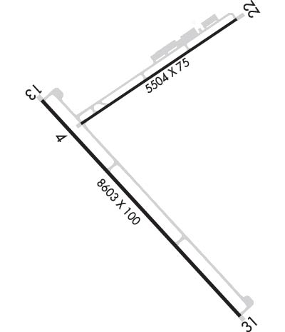
| Rwy | Rwy | |||||||
| 5504x75 | 5504' | 5504x75 | 5504' | |||||
| 8600x100 | 8600' | 8600x100 | 8600' | |||||
| Runway ID | Single Wheel | Double Wheel | Double Tandem Wheel | Dual Double Wheel |
| 04/22 | 24,000 | N/A | N/A | N/A |
| 13/31 | 60,000 | N/A | N/A | N/A |
| These numbers are Advisory and are not limits. The Airport Manager should have more accurate Weight Limits | ||||
 Airport Diagram might not be current. | |
| Facility Name: | TAOS RGNL |
| City Name: | TAOS |
| County: | TAOS |
| State abbrev: | NM |
| State Name: | NEW MEXICO |
| Ownership: | PUBLICLY OWNED |
| Use: | OPEN TO THE PUBLIC |
| Owner's Name: | TOWN OF TAOS |
| Address: | 400 CAMINO DE LA PLACITA |
| TAOS, NM 87571-6071 | |
| Owner's Phone: | 575-751-2000 |
| Manager's Name: | COLTON RAPSTINE |
| Address: | 24662 HIGHWAY 64; PHYSICAL ADDRESS 24662 HWY 64, EL PRADO NM 87529 |
| EL PRADO, NM 87529 | |
| Phone: | 575-770-1699; EMER FONE: 575-770-1699 (CELL). |
| FAA Region: | SOUTHWEST |
| FAA Field Office: | LNM |

| Date | Sunrise | Sunset |
|---|---|---|
| 06/08/26 Monday | 5:44 | 20:19 |
| 06/09/26 Tuesday | 5:44 | 20:20 |
| 06/10/26 Wednesday | 5:44 | 20:20 |
| 06/11/26 Thursday | 5:44 | 20:21 |
| 06/12/26 Friday | 5:44 | 20:21 |
| 06/13/26 Saturday | 5:44 | 20:22 |
| 06/14/26 Sunday | 5:44 | 20:22 |
| 06/15/26 Monday | 5:44 | 20:22 |
| 06/16/26 Tuesday | 5:44 | 20:23 |
| 06/17/26 Wednesday | 5:44 | 20:23 |
| 06/18/26 Thursday | 5:44 | 20:23 |
| 06/19/26 Friday | 5:44 | 20:24 |
| 06/20/26 Saturday | 5:45 | 20:24 |
| 06/21/26 Sunday | 5:45 | 20:24 |
| Airport Attendance Schedule | 7 Days A Week 0730-1800 |
| Airport Status | OPERATIONAL (This Status can change at any time - please check NOTAMS) |
| Airport Lighting Schedule | ACTVT REIL RWY 04, 13, 31; PAPI RWY 04, 13, 22, 31; MIRL RWY 04/22, 13/31 - CTAF. |
| Airport Storage Available | Tie Downs, Hanger |
| Extra Services Available | Air Ambulance, Flight Instruction |
| Wind Indicator | YES - (lighted) |
| Control Tower | NO |
| CTAF Frequency | 122.800 |
| Unicom Frequency | 122.800 |
| Rotating Beacon Color | WG |
| Segmented Circle | YES |
| Landing Fee | NO |
| Airport Inspected | STATE - performed by PRIVATE CONTRACT PERSONNEL |
| Inspection Date | 04/13/2025 |
| Type of Fuel Available | Grade 100LL, JET A-1 (icing inhibitor, freeze point -50C); -10FOR AFT HRS FUEL SVC CALL 575-758-5436. AFT HRS CALLOUT FEE CHARGED FOR JET A. |
| Airframe Repair Service | MINOR |
| Power Plant Repair Service | MINOR |
| Latitude | N3627.1 |
| Longitude | W10540.4 (ESTIMATED) |
| Arpt Elevation | 7094ft (SURVEYED) |
| Magnetic Variation | 09E |
| 8 miles NW | of TAOS |
| Traffic Pattern Altitude | |
| Sectional Chart | DENVER |
| Operations (Reported) | Yearly | Avg. Daily |
|---|---|---|
| General Aviation Transient | 0 | 0 |
| General Aviation Local | 0 | 0 |
| Air Taxi | 0 | 0 |
| Commerical | 0 | 0 |
| Commuter | 0 | 0 |
| Military | 0 | 0 |
| Aircraft based on Field | |
|---|---|
| General Aviation Singles | 0 |
| General Aviation Multi | 0 |
| Jet Aircraft | 0 |
| General Aviation Helicopters | 0 |
| Military Aircraft | 0 |
| Gliders | 0 |
| Ultralights | 0 |
| FSS on field | NO |
| FSS tie-in | ALBUQUERQUE |
| FSS Phone | 1-800-WX-BRIEF |
| Who issues Notams | SKX |
| Notam D service at airport | YES |
| ARTCC Name | ALBUQUERQUE |
| Airport Certification | |
| Aircraft Rescue & Firefighting Index | None |
| Airport of Entry | No |
| Custom Landing Rights | No |
| Joint Civil/Military | No |
| Military Landing rights | YES |
| NATIONAL PLAN OF INTEGRATED AIRPORT SYSTEMS (NPIAS) |
| GRANT AGREEMENTS UNDER FAAP/ADAP/AIP |
| ASSURANCES PURSUANT TO TITLE VI, CIVIL RIGHTS ACT OF 1964 |
| THIS AIRPORT HAS BEEN SURVEYED BY THE NATIONAL GEODETIC SURVEY. |
| AVOID OVERFLIGHT OF TAOS PUEBLO WORLD HERITAGE SITE 5 NM EAST OF ARPT. |
| RWY 04/22 PARALLEL TWY HAS RETRO-REFLECTORS. |
| WILDLIFE INVOF ARPT. |
| FOR CD IF UNA TO CTC ON FSS FREQ, CTC ALBUQUERQUE ARTCC AT 505-856-4561. |
| RWY 04/2 2 RWY 04: 150 FT BLAST PAD. RWY 22: 250 FT BLAST PAD. |
| RWY 13/3 1 RWY 13: 150 FT BLAST PAD. RWY 31: 150 FT BLAST PAD. |
Airport Communications & Frequencies:
| |||||||||
| Runway: 04 | Runway: 22 | ||
| Mag heading: | 47° | Mag heading: | 227° |
| Rwy Slope: | .77% Up | Rwy Slope: | -.77% Down |
| Approach: | Approach: | ||
| Pattern: | Left Traffic | Pattern: | Left Traffic |
| Markings: | NONPRECISION INSTRUMENT | Markings: | BASIC |
| Marking Condition: | GOOD | Marking Condition: | GOOD |
| Arresting Dev: | Arresting Dev: | ||
| Lat & Long: | N3627.3 W10540.8 | Lat. & Long.: | N3627.8 W10539.9 |
| Elev: | 7052.4 ft. MSL | Elev: | 7094.6 ft. MSL |
| TCH: | 40 ft. AGL | TCH: | 40 ft. AGL |
| Visual Glide Path: | 3.00 degrees | Visual Glide Path: | 3.00 degrees |
| Displaced Threshold: | No | Displaced Threshold: | No |
| Touchdown Zone: | YES | Touchdown Zone: | YES |
| Touchdown Elev.: | 7069.6 feet | Touchdown Elev.: | 7094.6 feet |
| Visual Glide Slope: | 4-Light PAPI on LEFT side of Runway | Visual Glide Slope: | 4-Light PAPI on LEFT side of Runway |
| RVR Equipment: | RVR Equipment: | ||
| RVV Equipment: | NO | RVV Equipment: | NO |
| Approach Lights: | Approach Lights: | ||
| REIL: | YES | REIL: | NO |
| Centerline Lights: | NO | Centerline Lights: | NO |
| Touchdown lights: | NO | Touchdown lights: | NO |
| Runway Category: | Runway with a Non-precision Approach having visibility minimums greater than 3/4 mile | Runway Category: | Runway with a Visual Approach |
| Declared Distances: | Declared Distances: |
| Runway: 13 | Runway: 31 | ||
| Mag heading: | 128° | Mag heading: | 308° |
| Rwy Slope: | -.26% Down | Rwy Slope: | .26% Up |
| Approach: | Approach: | ||
| Pattern: | Left Traffic | Pattern: | Left Traffic |
| Markings: | PRECISION INSTRUMENT | Markings: | NONPRECISION INSTRUMENT |
| Marking Condition: | GOOD | Marking Condition: | GOOD |
| Arresting Dev: | Arresting Dev: | ||
| Lat & Long: | N3627.4 W10541.0 | Lat. & Long.: | N3626.3 W10539.8 |
| Elev: | 7047.3 ft. MSL | Elev: | 7024.9 ft. MSL |
| TCH: | 37 ft. AGL | TCH: | 40 ft. AGL |
| Visual Glide Path: | 3.00 degrees | Visual Glide Path: | 3.00 degrees |
| Displaced Threshold: | No | Displaced Threshold: | No |
| Touchdown Zone: | YES | Touchdown Zone: | YES |
| Touchdown Elev.: | 7057.0 feet | Touchdown Elev.: | 7048.6 feet |
| Visual Glide Slope: | 4-Light PAPI on LEFT side of Runway | Visual Glide Slope: | 4-Light PAPI on LEFT side of Runway |
| RVR Equipment: | RVR Equipment: | ||
| RVV Equipment: | NO | RVV Equipment: | NO |
| Approach Lights: | Approach Lights: | ||
| REIL: | YES | REIL: | YES |
| Centerline Lights: | NO | Centerline Lights: | NO |
| Touchdown lights: | NO | Touchdown lights: | NO |
| Runway Category: | Runway with a Non-precision Approach having visibility minimums greater than 3/4 mile | Runway Category: | Runway with a Visual Approach |
| Declared Distances: | Declared Distances: |
Thanks for using FltPlan.com
all rights reserved © 1999-2026 by Flight Plan LLC