
| SISKIYOU COUNTY MONTAGUE CA |
| |
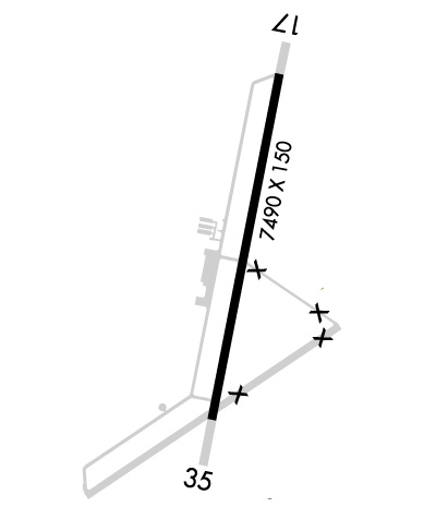
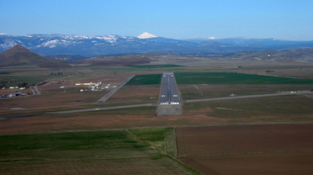
| Lat: N 4146.9 Long: W 12228.1 Elev: 2651 Var: -19 Longest Runway: 7490 | ||
| AWOS: 121.12 CTAF: 123.0 | ||
| |||||||||||||||||||||||||||||||||||||||||||||||||||||||||||||
| |||||||||||||||||||||||||||||||||||||||||||||||||||||||||||||
| |||||||||||||||||||||||||||||||||||||||||||||||||||||||||||||
| Rwy | Rwy | |||||||
| 7490x150 | 7490' | 7490x150 | 7490' | |||||
| Runway ID | Single Wheel | Double Wheel | Double Tandem Wheel | Dual Double Wheel |
| 17/35 | 60,000 | 180,000 | 270,000 | N/A |
| These numbers are Advisory and are not limits. The Airport Manager should have more accurate Weight Limits | ||||
 Airport Diagram might not be current. | |
| Facility Name: | SISKIYOU COUNTY |
| City Name: | MONTAGUE |
| County: | SISKIYOU |
| State abbrev: | CA |
| State Name: | CALIFORNIA |
| Ownership: | PUBLICLY OWNED |
| Use: | OPEN TO THE PUBLIC |
| Owner's Name: | SISKIYOU COUNTY |
| Address: | 190 GREENHORN ROAD |
| YREKA, CA 96097 | |
| Owner's Phone: | (530) 842-8259 |
| Manager's Name: | JASON LEDBETTER; EMAIL: JLEDBETTER@CO.SISKIYOU.CA.US |
| Address: | 190 GREENHORN ROAD |
| YREKA, CA 96097 | |
| Phone: | (530) 842-8259; COUNTY AIRPORT OFFICE - YREKA. |
| FAA Region: | WESTERN-PACIFIC |
| FAA Field Office: | SFO |
| Date | Sunrise | Sunset |
|---|---|---|
| 09/24/21 Friday | 6:59 | 19:04 |
| 09/25/21 Saturday | 7:00 | 19:02 |
| 09/26/21 Sunday | 7:01 | 19:00 |
| 09/27/21 Monday | 7:02 | 18:59 |
| 09/28/21 Tuesday | 7:03 | 18:57 |
| 09/29/21 Wednesday | 7:04 | 18:55 |
| 09/30/21 Thursday | 7:06 | 18:53 |
| 10/01/21 Friday | 7:07 | 18:52 |
| 10/02/21 Saturday | 7:08 | 18:50 |
| 10/03/21 Sunday | 7:09 | 18:48 |
| 10/04/21 Monday | 7:10 | 18:47 |
| 10/05/21 Tuesday | 7:11 | 18:45 |
| 10/06/21 Wednesday | 7:12 | 18:43 |
| 10/07/21 Thursday | 7:13 | 18:42 |
| Airport Attendance Schedule | 7 Days A Week 0800-1700 |
| Airport Status | OPERATIONAL (This Status can change at any time - please check NOTAMS) |
| Airport Lighting Schedule | ACTVT MIRL RY 17/35, PAPI RYS 17 AND 35, REIL RYS 17 AND 35 - CTAF. |
| Airport Storage Available | Tie Downs |
| Extra Services Available | Crop Dusting, Charter |
| Wind Indicator | YES - (lighted) |
| Control Tower | NO |
| CTAF Frequency | 123.000 |
| Unicom Frequency | 123.000 |
| Rotating Beacon Color | CLEAR-GREEN (Light Land Airport) |
| Segmented Circle | YES |
| Landing Fee | YES |
| Airport Inspected | STATE - performed by STATE AERONAUTICAL PERSONNEL |
| Inspection Date | 11/24/2020 |
| Type of Fuel Available | JET A (freeze point -40C) |
| Airframe Repair Service | MAJOR |
| Power Plant Repair Service | MAJOR |
| Latitude | N4146.9 |
| Longitude | W12228.1 (ESTIMATED) |
| Arpt Elevation | 2651ft (SURVEYED) |
| Magnetic Variation | 19E |
| 3 miles NE | of MONTAGUE |
| Traffic Pattern Altitude | |
| Sectional Chart | KLAMATH FALLS |
| Operations (Reported) | Yearly | Avg. Daily |
|---|---|---|
| General Aviation Transient | 6000 | 16 |
| General Aviation Local | 7500 | 21 |
| Air Taxi | 150 | 0 |
| Commerical | 0 | 0 |
| Commuter | 0 | 0 |
| Military | 100 | 0 |
| Aircraft based on Field | |
|---|---|
| General Aviation Singles | 8 |
| General Aviation Multi | 1 |
| Jet Aircraft | 0 |
| General Aviation Helicopters | 0 |
| Military Aircraft | 0 |
| Gliders | 2 |
| Ultralights | 0 |
| FSS on field | NO |
| FSS tie-in | RANCHO MURIETA |
| FSS Phone | 1-800-WX-BRIEF |
| Who issues Notams | SIY |
| Notam D service at airport | YES |
| ARTCC Name | SEATTLE |
| Airport Certification | |
| Aircraft Rescue & Firefighting Index | None |
| Airport of Entry | No |
| Custom Landing Rights | No |
| Joint Civil/Military | No |
| Military Landing rights | YES |
| NATIONAL PLAN OF INTEGRATED AIRPORT SYSTEMS (NPIAS) |
| GRANT AGREEMENTS UNDER FAAP/ADAP/AIP |
| SURPLUS PROPERTY AGREEMENT UNDER PUBLIC LAW 289 |
| ASSURANCES PURSUANT TO TITLE VI, CIVIL RIGHTS ACT OF 1964 |
| MIGRATORY FLOCKS OF WATERFOWL IN THE VICINITY OF ARPT DURING SPRING & FALL. |
| USFS FIRE OPS MAY-SEP. |
| BE ALERT FOR GLIDER OPS MAY-SEP. |
| SENSITIVE AG CROPS ADJACENT TO RWY/TWY. ROTOCRAFT SHOULD AVOID OPERATING IN THESE AREAS. |
| WILDLIFE IN THE VICINITY OF ARPT. |
| FARMING ACTIVITIES AND EQUIPMENT INVOF RWYS AND TWYS. |
| FOR CD CTC SEATTLE ARTCC AT 253-351-3694. |
Airport Communications & Frequencies:
| |||||||||
| Runway: 17 | Runway: 35 | ||
| Mag heading: | 172° | Mag heading: | 352° |
| Rwy Slope: | -.26% Down | Rwy Slope: | .26% Up |
| Approach: | Approach: | ||
| Pattern: | Left Traffic | Pattern: | Right Traffic |
| Markings: | NONPRECISION INSTRUMENT | Markings: | NONPRECISION INSTRUMENT |
| Marking Condition: | GOOD | Marking Condition: | GOOD |
| Arresting Dev: | Arresting Dev: | ||
| Lat & Long: | N4147.5 W12227.9 | Lat. & Long.: | N4146.3 W12228.2 |
| Elev: | 2651.0 ft. MSL | Elev: | 2631.5 ft. MSL |
| TCH: | 50 ft. AGL | TCH: | 50 ft. AGL |
| Visual Glide Path: | 3.00 degrees | Visual Glide Path: | 3.00 degrees |
| Displaced Threshold: | No | Displaced Threshold: | No |
| Touchdown Zone: | YES | Touchdown Zone: | YES |
| Touchdown Elev.: | 2651.1 feet | Touchdown Elev.: | 2639.6 feet |
| Visual Glide Slope: | 2-Light PAPI on LEFT side of Runway | Visual Glide Slope: | 2-Light PAPI on LEFT side of Runway |
| RVR Equipment: | RVR Equipment: | ||
| RVV Equipment: | NO | RVV Equipment: | NO |
| Approach Lights: | Approach Lights: | ||
| REIL: | YES | REIL: | YES |
| Centerline Lights: | NO | Centerline Lights: | NO |
| Touchdown lights: | NO | Touchdown lights: | NO |
| Runway Category: | Runway with a Visual Approach | Runway Category: | Runway with a Visual Approach |
| Declared Distances: | Declared Distances: | ||
| Obstructions: | ROAD | Obstructions: | |
| Marked: | NOT Marked/Lighted | Marked: | |
| Clearance slope: | 43:1 | Clearance slope: | 50:1 |
| Obstruction height: | 15 feet AGL | Obstruction height: | |
| Dist. from runway: | 850 feet | Dist. from runway: | |
| Centerline offset: | Centerline offset: | ||
| Comments: | Comments: |
Thanks for using FltPlan.com
all rights reserved © 1999-2021 by Flight Plan LLC
