
| SHREVEPORT RGNL SHREVEPORT LA |
| |
| Lat: N 3226.8 Long: W 09349.6 Elev: 258 Var: -02 Longest Runway: 8348 | ||
| Clr Del: 124.65 Dept. ATIS: 128.45 Arr. ATIS: 128.45 Ground: 121.17 Tower: 121.4 | ||
| ||||||||||||||||||||||||||||||||||||||||||||||||||||||||||||||||||||
| ||||||||||||||||||||||||||||||||||||||||||||||||||||||||||||||||||||
| ||||||||||||||||||||||||||||||||||||||||||||||||||||||||||||||||||||
| Rwy | Rwy | |||||||
| 7003x150 | 7003' | 109.10 - 058° | 7003x150 | 7003' | ||||
| 8348x200 | 8348' | 110.70 - 140° | 8348x200 | 7975' | 110.30 - 320° | |||
| Runway ID | Single Wheel | Double Wheel | Double Tandem Wheel | Dual Double Wheel |
| 06/24 | 120,000 | 218,000 | 370,000 | N/A |
| 14/32 | 120,000 | 218,000 | 370,000 | N/A |
| These numbers are Advisory and are not limits. The Airport Manager should have more accurate Weight Limits | ||||
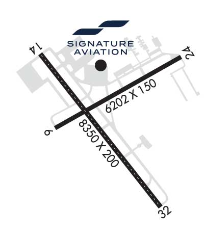 Airport Diagram might not be current. | |
| Facility Name: | SHREVEPORT RGNL |
| City Name: | SHREVEPORT |
| County: | CADDO |
| State abbrev: | LA |
| State Name: | LOUISIANA |
| Ownership: | PUBLICLY OWNED |
| Use: | OPEN TO THE PUBLIC |
| Owner's Name: | CITY OF SHREVEPORT |
| Address: | 505 TRAVIS STREET |
| SHREVEPORT, LA 71101 | |
| Owner's Phone: | 318-673-5050 |
| Manager's Name: | LARRY BLACKWELL |
| Address: | 5103 HOLLYWOOD AVE SUITE 300 |
| SHREVEPORT, LA 71109 | |
| Phone: | 318-673-5370 |
| FAA Region: | SOUTHWEST |
| FAA Field Office: | LNM |

| Date | Sunrise | Sunset |
|---|---|---|
| 06/08/26 Monday | 6:08 | 20:21 |
| 06/09/26 Tuesday | 6:08 | 20:22 |
| 06/10/26 Wednesday | 6:08 | 20:22 |
| 06/11/26 Thursday | 6:08 | 20:22 |
| 06/12/26 Friday | 6:07 | 20:23 |
| 06/13/26 Saturday | 6:08 | 20:23 |
| 06/14/26 Sunday | 6:08 | 20:24 |
| 06/15/26 Monday | 6:08 | 20:24 |
| 06/16/26 Tuesday | 6:08 | 20:24 |
| 06/17/26 Wednesday | 6:08 | 20:25 |
| 06/18/26 Thursday | 6:08 | 20:25 |
| 06/19/26 Friday | 6:08 | 20:25 |
| 06/20/26 Saturday | 6:08 | 20:25 |
| 06/21/26 Sunday | 6:08 | 20:26 |
| Airport Attendance Schedule | CONTINUOUS |
| Airport Status | OPERATIONAL (This Status can change at any time - please check NOTAMS) |
| Airport Lighting Schedule | SS-SR |
| Airport Storage Available | Tie Downs, Hanger |
| Extra Services Available | Air Freight, Avionics, Cargo Handling, Charter |
| Wind Indicator | YES - (lighted) |
| Control Tower | YES |
| CTAF Frequency | |
| Unicom Frequency | 122.950 |
| Rotating Beacon Color | WG |
| Segmented Circle | NO |
| Landing Fee | NO; LNDG FEE FOR ALL COMMERCIAL TFC. |
| Airport Inspected | FEDERAL - performed by FAA AIRPORTS FIELD PERSONNEL |
| Inspection Date | 01/29/2026 |
| Type of Fuel Available | Grade 100LL, JET A (freeze point -40C) |
| Airframe Repair Service | MAJOR |
| Power Plant Repair Service | MAJOR |
| Latitude | N3226.8 |
| Longitude | W09349.6 (ESTIMATED) |
| Arpt Elevation | 257ft (SURVEYED) |
| Magnetic Variation | 02E |
| 4 miles SW | of SHREVEPORT |
| Traffic Pattern Altitude | |
| Sectional Chart | MEMPHIS |
| Operations (Reported) | Yearly | Avg. Daily |
|---|---|---|
| General Aviation Transient | 0 | 0 |
| General Aviation Local | 0 | 0 |
| Air Taxi | 0 | 0 |
| Commerical | 0 | 0 |
| Commuter | 0 | 0 |
| Military | 0 | 0 |
| Aircraft based on Field | |
|---|---|
| General Aviation Singles | 0 |
| General Aviation Multi | 0 |
| Jet Aircraft | 0 |
| General Aviation Helicopters | 0 |
| Military Aircraft | 0 |
| Gliders | 0 |
| Ultralights | 0 |
| FSS on field | NO |
| FSS tie-in | DE RIDDER |
| FSS Phone | 1-800-WX-BRIEF |
| Who issues Notams | SHV |
| Notam D service at airport | YES |
| ARTCC Name | FORT WORTH |
| Airport Certification | AIRPORT RECEIVING SCHEDULED AIR CARRIER SERVICE FROM CARRIERS CERTIFICATED BY THE CIVIL AERONAUTICS BOARD |
| Aircraft Rescue & Firefighting Index | AIRPORT HAS A CERTIFICATE UNDER CFR PART 139 |
| Airport of Entry | No |
| Custom Landing Rights | YES |
| Joint Civil/Military | No |
| Military Landing rights | YES |
| NATIONAL PLAN OF INTEGRATED AIRPORT SYSTEMS (NPIAS) |
| GRANT AGREEMENTS UNDER FAAP/ADAP/AIP |
| ASSURANCES PURSUANT TO TITLE VI, CIVIL RIGHTS ACT OF 1964 |
| FLIGHT NOTIFICATION SERVICE (ADCUS) AVBL MON-FRI 0800-1700; OTHER TIMES BY APPOINTMENT CALL 318-635-7873 OR 800-973-2867. |
| BIRD ACTIVITY INVOF ARPT. |
| SFC COND NOT MNT DLY 0700-1100 |
| RWY 06/2 4 PCR VALUE: 542/F/B/X/T |
| RWY 14/3 2 PCR VALUE: 542/F/B/X/T |
Airport Communications & Frequencies:
| ||||||||||||||||||||||||||||
| Runway: 06 | Runway: 24 | ||
| Mag heading: | 59° | Mag heading: | 239° |
| Rwy Slope: | -.14% Down | Rwy Slope: | .14% Up |
| Approach: | LOC/DME | Approach: | |
| Pattern: | Left Traffic | Pattern: | Left Traffic |
| Markings: | NONPRECISION INSTRUMENT | Markings: | NONPRECISION INSTRUMENT |
| Marking Condition: | GOOD | Marking Condition: | GOOD |
| Arresting Dev: | Arresting Dev: | ||
| Lat & Long: | N3226.6 W09350.1 | Lat. & Long.: | N3227.2 W09348.9 |
| Elev: | 238.3 ft. MSL | Elev: | 228.4 ft. MSL |
| TCH: | 50 ft. AGL | TCH: | 50 ft. AGL |
| Visual Glide Path: | 3.00 degrees | Visual Glide Path: | 3.00 degrees |
| Displaced Threshold: | No | Displaced Threshold: | No |
| Touchdown Zone: | YES | Touchdown Zone: | YES |
| Touchdown Elev.: | 238.3 feet | Touchdown Elev.: | 237.0 feet |
| Visual Glide Slope: | 4-Light PAPI on LEFT side of Runway | Visual Glide Slope: | 4-Light PAPI on LEFT side of Runway |
| RVR Equipment: | RVR Equipment: | ||
| RVV Equipment: | NO | RVV Equipment: | NO |
| Approach Lights: | Approach Lights: | ||
| REIL: | YES | REIL: | YES |
| Centerline Lights: | NO | Centerline Lights: | NO |
| Touchdown lights: | NO | Touchdown lights: | NO |
| Runway Category: | Runway with a Non-precision Approach having visibility minimums greater than 3/4 mile | Runway Category: | Runway with a Non-precision Approach having visibility minimums greater than 3/4 mile |
| Declared Distances: | TORA:7003' TODA:7003' ASDA:7003' LDA:7003' | Declared Distances: | TORA:7003' TODA:7003' ASDA:7003' LDA:7003' |
| Obstructions: | TREES | Obstructions: | TREES |
| Marked: | NOT Marked/Lighted | Marked: | NOT Marked/Lighted |
| Clearance slope: | 23:1 | Clearance slope: | 32:1 |
| Obstruction height: | 77 feet AGL | Obstruction height: | 111 feet AGL |
| Dist. from runway: | 2000 feet | Dist. from runway: | 3800 feet |
| Centerline offset: | 300 right of centerline | Centerline offset: | |
| Comments: | Comments: |
| Runway: 14 | Runway: 32 | ||
| Mag heading: | 141° | Mag heading: | 321° |
| Rwy Slope: | -.43% Down | Rwy Slope: | .43% Up |
| Approach: | ILS/DME | Approach: | ILS |
| Pattern: | Left Traffic | Pattern: | Left Traffic |
| Markings: | PRECISION INSTRUMENT | Markings: | PRECISION INSTRUMENT |
| Marking Condition: | GOOD | Marking Condition: | GOOD |
| Arresting Dev: | Arresting Dev: | ||
| Lat & Long: | N3227.2 W09350.1 | Lat. & Long.: | N3226.1 W09349.1 |
| Elev: | 257.6 ft. MSL | Elev: | 222.1 ft. MSL |
| TCH: | 50 ft. AGL | TCH: | |
| Visual Glide Path: | 3.00 degrees | Visual Glide Path: | |
| Displaced Threshold: | No | Displaced Threshold: | 373 feet |
| Touchdown Zone: | YES | Touchdown Zone: | YES |
| Touchdown Elev.: | 257.6 feet | Touchdown Elev.: | 221.9 feet |
| Visual Glide Slope: | 4-Light PAPI on RIGHT side of Runway | Visual Glide Slope: | |
| RVR Equipment: | TOUCHDOWN-MIDFIELD-ROLLOUT | RVR Equipment: | TOUCHDOWN-MIDFIELD-ROLLOUT |
| RVV Equipment: | NO | RVV Equipment: | NO |
| Approach Lights: | ALSF2 - standard 2,400 foot high intensity approach lighting system with sequenced flashers, Category II or III | Approach Lights: | MALSR - 1,400 foot medium intensity approach lighting system with runway alignment indicator lights |
| REIL: | NO | REIL: | NO |
| Centerline Lights: | YES | Centerline Lights: | YES |
| Touchdown lights: | YES | Touchdown lights: | NO |
| Runway Category: | Precision Instrument Runway | Runway Category: | Precision Instrument Runway |
| Declared Distances: | TORA:8348' TODA:8348' ASDA:8118' LDA:8118' | Declared Distances: | TORA:8348' TODA:8348' ASDA:8348' LDA:7975' |
| Obstructions: | Obstructions: | RR | |
| Marked: | Marked: | NOT Marked/Lighted | |
| Clearance slope: | 50:1 | Clearance slope: | 22:1; APCH RATIO 40:1 FM DSPLCD THR. |
| Obstruction height: | Obstruction height: | 32 feet AGL | |
| Dist. from runway: | Dist. from runway: | 920 feet | |
| Centerline offset: | Centerline offset: | 600 feet right of centerline | |
| Comments: | Comments: |
Thanks for using FltPlan.com
all rights reserved © 1999-2026 by Flight Plan LLC


