
| SANDERSON FIELD SHELTON WA |
| |
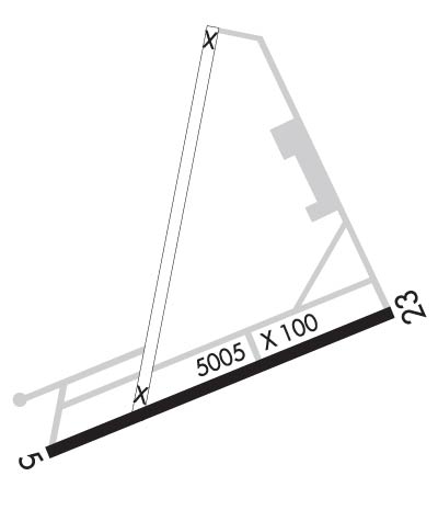
| Lat: N 4714.0 Long: W 12308.9 Elev: 273 Var: -15 Longest Runway: 5005 | ||
| AWOS: 119.27 CTAF: 122.8 | ||
| ||||||
| ||||||
|
| Rwy | Rwy | |||||||
| 5005x100 | 5005' | 5005x100 | 5005' | |||||
| Runway ID | Single Wheel | Double Wheel | Double Tandem Wheel | Dual Double Wheel |
| 05/23 | 55,000 | 72,000 | 130,000 | N/A |
| These numbers are Advisory and are not limits. The Airport Manager should have more accurate Weight Limits | ||||
 Airport Diagram might not be current. | |
| Facility Name: | SANDERSON FLD |
| City Name: | SHELTON |
| County: | MASON |
| State abbrev: | WA |
| State Name: | WASHINGTON |
| Ownership: | PUBLICLY OWNED |
| Use: | OPEN TO THE PUBLIC |
| Owner's Name: | PORT OF SHELTON |
| Address: | 21 WEST SANDERSON WAY |
| SHELTON, WA 98584 | |
| Owner's Phone: | 360-426-1151 |
| Manager's Name: | WENDY SMITH- EXECUTIVE DIRECTOR |
| Address: | 21 WEST SANDERSON WAY |
| SHELTON, WA 98584 | |
| Phone: | 360-426-1151 |
| FAA Region: | NORTHWEST MOUNTAIN |
| FAA Field Office: | SEA |
| Date | Sunrise | Sunset |
|---|---|---|
| 09/24/21 Friday | 7:02 | 19:07 |
| 09/25/21 Saturday | 7:03 | 19:04 |
| 09/26/21 Sunday | 7:05 | 19:02 |
| 09/27/21 Monday | 7:06 | 19:00 |
| 09/28/21 Tuesday | 7:07 | 18:58 |
| 09/29/21 Wednesday | 7:09 | 18:56 |
| 09/30/21 Thursday | 7:10 | 18:54 |
| 10/01/21 Friday | 7:11 | 18:52 |
| 10/02/21 Saturday | 7:13 | 18:50 |
| 10/03/21 Sunday | 7:14 | 18:48 |
| 10/04/21 Monday | 7:15 | 18:46 |
| 10/05/21 Tuesday | 7:17 | 18:44 |
| 10/06/21 Wednesday | 7:18 | 18:42 |
| 10/07/21 Thursday | 7:20 | 18:40 |
| Airport Attendance Schedule | MON-FRI 0800-1630 |
| Airport Status | OPERATIONAL (This Status can change at any time - please check NOTAMS) |
| Airport Lighting Schedule | ACTVT REIL RWY 23; PAPI RWY 23; MIRL RWY 05/23 - CTAF. |
| Airport Storage Available | Tie Downs |
| Extra Services Available | Charter, Flight Instruction, Parachute Jumping, Aircraft Rental |
| Wind Indicator | YES - (lighted) |
| Control Tower | NO |
| CTAF Frequency | 122.800 |
| Unicom Frequency | 122.800 |
| Rotating Beacon Color | CLEAR-GREEN (Light Land Airport); BCN ON WATER TWR NORTH OF RY. |
| Segmented Circle | YES |
| Landing Fee | NO |
| Airport Inspected | STATE - performed by STATE AERONAUTICAL PERSONNEL |
| Inspection Date | 05/14/2021 |
| Type of Fuel Available | Grade 100LL, JET A (freeze point -40C); -1024 HR CREDIT CARD FUEL FAC. |
| Airframe Repair Service | MAJOR |
| Power Plant Repair Service | MAJOR |
| Latitude | N4714.0 |
| Longitude | W12308.9 (ESTIMATED) |
| Arpt Elevation | 272ft (SURVEYED) |
| Magnetic Variation | 15E |
| 3 miles NW | of SHELTON |
| Traffic Pattern Altitude | |
| Sectional Chart | SEATTLE |
| Operations (Reported) | Yearly | Avg. Daily |
|---|---|---|
| General Aviation Transient | 26500 | 73 |
| General Aviation Local | 11570 | 32 |
| Air Taxi | 400 | 1 |
| Commerical | 0 | 0 |
| Commuter | 0 | 0 |
| Military | 9460 | 26 |
| Aircraft based on Field | |
|---|---|
| General Aviation Singles | 65 |
| General Aviation Multi | 2 |
| Jet Aircraft | 0 |
| General Aviation Helicopters | 4 |
| Military Aircraft | 0 |
| Gliders | 0 |
| Ultralights | 5 |
| FSS on field | NO |
| FSS tie-in | SEATTLE |
| FSS Phone | 1-800-WX-BRIEF |
| Who issues Notams | SHN |
| Notam D service at airport | YES |
| ARTCC Name | SEATTLE |
| Airport Certification | |
| Aircraft Rescue & Firefighting Index | None |
| Airport of Entry | No |
| Custom Landing Rights | No |
| Joint Civil/Military | No |
| Military Landing rights | YES |
| NATIONAL PLAN OF INTEGRATED AIRPORT SYSTEMS (NPIAS) |
| GRANT AGREEMENTS UNDER FAAP/ADAP/AIP |
| SURPLUS PROPERTY AGREEMENT UNDER PUBLIC LAW 289 |
| ASSURANCES PURSUANT TO TITLE VI, CIVIL RIGHTS ACT OF 1964 |
| (E94) SAWRS |
| PARACHUTE OPERATIONS ON THE FIELD AVOID CROSSING MIDFIELD TO ENTER TRAFFIC PATTERN. |
| FOR CD CTC SEATTLE APCH AT 206-214-4723. |
Airport Communications & Frequencies:
| ||||||||||||||
| Runway: 05 | Runway: 23 | ||
| Mag heading: | 53° | Mag heading: | 233° |
| Rwy Slope: | .29% Up | Rwy Slope: | -.29% Down |
| Approach: | Approach: | ||
| Pattern: | Right Traffic | Pattern: | Left Traffic |
| Markings: | NONPRECISION INSTRUMENT | Markings: | NONPRECISION INSTRUMENT |
| Marking Condition: | GOOD | Marking Condition: | GOOD |
| Arresting Dev: | Arresting Dev: | ||
| Lat & Long: | N4713.9 W12309.4 | Lat. & Long.: | N4714.2 W12308.3 |
| Elev: | 258.6 ft. MSL | Elev: | 272.9 ft. MSL |
| TCH: | TCH: | 47 ft. AGL | |
| Visual Glide Path: | Visual Glide Path: | 3.00 degrees | |
| Displaced Threshold: | No | Displaced Threshold: | No |
| Touchdown Zone: | YES | Touchdown Zone: | YES |
| Touchdown Elev.: | 269.6 feet | Touchdown Elev.: | 272.9 feet |
| Visual Glide Slope: | Visual Glide Slope: | 4-Light PAPI on LEFT side of Runway | |
| RVR Equipment: | RVR Equipment: | ||
| RVV Equipment: | NO | RVV Equipment: | NO |
| Approach Lights: | Approach Lights: | ||
| REIL: | NO | REIL: | YES |
| Centerline Lights: | NO | Centerline Lights: | NO |
| Touchdown lights: | NO | Touchdown lights: | NO |
| Runway Category: | Runway with a Visual Approach | Runway Category: | Runway with a Non-precision Approach having visibility minimums greater than 3/4 mile |
| Declared Distances: | Declared Distances: | ||
| Obstructions: | TREES | Obstructions: | TREES |
| Marked: | NOT Marked/Lighted | Marked: | NOT Marked/Lighted |
| Clearance slope: | 17:1 | Clearance slope: | 22:1 |
| Obstruction height: | 49 feet AGL | Obstruction height: | 80 feet AGL |
| Dist. from runway: | 1053 feet | Dist. from runway: | 2298 feet |
| Centerline offset: | 141 right of centerline | Centerline offset: | |
| Comments: | Comments: |
Thanks for using FltPlan.com
all rights reserved © 1999-2021 by Flight Plan LLC
