
| SUFFOLK EXECUTIVE SUFFOLK VA |
| |
| Lat: N 3641.0 Long: W 07636.0 Elev: 70 Var: +10 Longest Runway: 5007 | ||
| AWOS: 119.37 CTAF: 122.7 | ||
| |||||||||||||||||||||||||||||||||||||||||||||||||||||||||||||
| |||||||||||||||||||||||||||||||||||||||||||||||||||||||||||||
| |||||||||||||||||||||||||||||||||||||||||||||||||||||||||||||
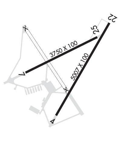
| Rwy | Rwy | |||||||
| 5007x100 | 5007' | 109.95 - 040° | 5007x100 | 5007' | ||||
| 3750x100 | 3750' | 3750x100 | 3750' | |||||
| Runway ID | Single Wheel | Double Wheel | Double Tandem Wheel | Dual Double Wheel |
| 04/22 | 30,000 | 60,000 | 60,000 | N/A |
| 07/25 | 30,000 | 50,000 | 85,000 | N/A |
| These numbers are Advisory and are not limits. The Airport Manager should have more accurate Weight Limits | ||||
 Airport Diagram might not be current. | |
| Facility Name: | SUFFOLK EXEC |
| City Name: | SUFFOLK |
| County: | SUFFOLK |
| State abbrev: | VA |
| State Name: | VIRGINIA |
| Ownership: | PUBLICLY OWNED |
| Use: | OPEN TO THE PUBLIC |
| Owner's Name: | CITY OF SUFFOLK |
| Address: | PO BOX 1858 |
| SUFFOLK, VA 23434 | |
| Owner's Phone: | 757-514-4000 |
| Manager's Name: | TIM DANIEL |
| Address: | 1200 GENE BOLTON DRIVE |
| SUFFOLK, VA 23434 | |
| Phone: | 757-514-4411 |
| FAA Region: | EASTERN |
| FAA Field Office: | DCA |
| Date | Sunrise | Sunset |
|---|---|---|
| 09/24/21 Friday | 6:56 | 19:01 |
| 09/25/21 Saturday | 6:56 | 18:59 |
| 09/26/21 Sunday | 6:57 | 18:58 |
| 09/27/21 Monday | 6:58 | 18:56 |
| 09/28/21 Tuesday | 6:59 | 18:55 |
| 09/29/21 Wednesday | 7:00 | 18:53 |
| 09/30/21 Thursday | 7:01 | 18:52 |
| 10/01/21 Friday | 7:01 | 18:50 |
| 10/02/21 Saturday | 7:02 | 18:49 |
| 10/03/21 Sunday | 7:03 | 18:47 |
| 10/04/21 Monday | 7:04 | 18:46 |
| 10/05/21 Tuesday | 7:05 | 18:44 |
| 10/06/21 Wednesday | 7:06 | 18:43 |
| 10/07/21 Thursday | 7:07 | 18:41 |
| Airport Attendance Schedule | 7 Days A Week 0800-1700 |
| Airport Status | OPERATIONAL (This Status can change at any time - please check NOTAMS) |
| Airport Lighting Schedule | ACTVT MIRL RWY 07/25, HIRL RWY 04/22, & REIL RWYS 04 & 22 - CTAF. |
| Airport Storage Available | Tie Downs |
| Extra Services Available | Crop Dusting, Charter, Flight Instruction, Parachute Jumping, Aircraft Rental |
| Wind Indicator | YES - (lighted) |
| Control Tower | NO |
| CTAF Frequency | 122.700 |
| Unicom Frequency | 122.700 |
| Rotating Beacon Color | CLEAR-GREEN (Light Land Airport) |
| Segmented Circle | YES |
| Landing Fee | NO |
| Airport Inspected | STATE - performed by STATE AERONAUTICAL PERSONNEL |
| Inspection Date | 10/15/2020 |
| Type of Fuel Available | Grade 100LL, JET A (freeze point -40C)MOGAS |
| Airframe Repair Service | MAJOR |
| Power Plant Repair Service | MAJOR |
| Latitude | N3641.0 |
| Longitude | W07636.0 (ESTIMATED) |
| Arpt Elevation | 70ft (SURVEYED) |
| Magnetic Variation | 10W |
| 3 miles SW | of SUFFOLK |
| Traffic Pattern Altitude | |
| Sectional Chart | WASHINGTON |
| Operations (Reported) | Yearly | Avg. Daily |
|---|---|---|
| General Aviation Transient | 3500 | 10 |
| General Aviation Local | 35953 | 99 |
| Air Taxi | 653 | 2 |
| Commerical | 0 | 0 |
| Commuter | 0 | 0 |
| Military | 550 | 2 |
| Aircraft based on Field | |
|---|---|
| General Aviation Singles | 45 |
| General Aviation Multi | 8 |
| Jet Aircraft | 1 |
| General Aviation Helicopters | 1 |
| Military Aircraft | 0 |
| Gliders | 1 |
| Ultralights | 0 |
| FSS on field | NO |
| FSS tie-in | LEESBURG |
| FSS Phone | 1-800-WX-BRIEF |
| Who issues Notams | SFQ |
| Notam D service at airport | YES |
| ARTCC Name | WASHINGTON |
| Airport Certification | |
| Aircraft Rescue & Firefighting Index | None |
| Airport of Entry | No |
| Custom Landing Rights | No |
| Joint Civil/Military | No |
| Military Landing rights | YES |
| NATIONAL PLAN OF INTEGRATED AIRPORT SYSTEMS (NPIAS) |
| GRANT AGREEMENTS UNDER FAAP/ADAP/AIP |
| ASSURANCES PURSUANT TO TITLE VI, CIVIL RIGHTS ACT OF 1964 |
| SURPLUS PROPERTY AGREEMENT UNDER PUBLIC LAW 289 |
| AGREEMENT UNDER DLAND OR DCLA HAS EXPIRED. |
| DEER ON & INVOF ARPT. |
| FOR CD CTC NORFOLK APCH AT 757-464-0757. |
| RWY 07 1 RWY END ARROW HEADS PAINTED WHITE INSTEAD OF DESIGNED AVIATION YELLOW. |
Airport Communications & Frequencies:
| ||||||||||||||
| Runway: 04 | Runway: 22 | ||
| Mag heading: | 40° | Mag heading: | 220° |
| Rwy Slope: | .05% Up | Rwy Slope: | -.05% Down |
| Approach: | LOC/DME | Approach: | |
| Pattern: | Right Traffic | Pattern: | Left Traffic |
| Markings: | NONPRECISION INSTRUMENT | Markings: | NONPRECISION INSTRUMENT |
| Marking Condition: | GOOD | Marking Condition: | GOOD |
| Arresting Dev: | Arresting Dev: | ||
| Lat & Long: | N3640.6 W07636.1 | Lat. & Long.: | N3641.3 W07635.6 |
| Elev: | 66.3 ft. MSL | Elev: | 68.8 ft. MSL |
| TCH: | 39 ft. AGL | TCH: | 45 ft. AGL |
| Visual Glide Path: | 3.00 degrees | Visual Glide Path: | 3.50 degrees |
| Displaced Threshold: | No | Displaced Threshold: | No |
| Touchdown Zone: | YES | Touchdown Zone: | YES |
| Touchdown Elev.: | 66.3 feet | Touchdown Elev.: | 68.8 feet |
| Visual Glide Slope: | 4-Light PAPI on LEFT side of Runway | Visual Glide Slope: | 4-Light PAPI on LEFT side of Runway |
| RVR Equipment: | RVR Equipment: | ||
| RVV Equipment: | NO | RVV Equipment: | NO |
| Approach Lights: | Approach Lights: | ||
| REIL: | YES | REIL: | YES |
| Centerline Lights: | NO | Centerline Lights: | NO |
| Touchdown lights: | NO | Touchdown lights: | NO |
| Runway Category: | Runway with a Non-precision Approach having visibility minimums greater than 3/4 mile | Runway Category: | Runway with a Non-precision Approach having visibility minimums greater than 3/4 mile |
| Declared Distances: | Declared Distances: | ||
| Obstructions: | TREE | Obstructions: | TREES |
| Marked: | NOT Marked/Lighted | Marked: | NOT Marked/Lighted |
| Clearance slope: | 30:1 | Clearance slope: | 17:1 |
| Obstruction height: | 81 feet AGL | Obstruction height: | 55 feet AGL |
| Dist. from runway: | 2630 feet | Dist. from runway: | 1155 feet |
| Centerline offset: | 425 right of centerline | Centerline offset: | 388 feet left of centerline |
| Comments: | Comments: |
| Runway: 07 | Runway: 25 | ||
| Mag heading: | 74° | Mag heading: | 254° |
| Rwy Slope: | -.04% Down | Rwy Slope: | .04% Up |
| Approach: | Approach: | ||
| Pattern: | Left Traffic | Pattern: | Right Traffic |
| Markings: | NONSTANDARD | Markings: | NONPRECISION INSTRUMENT |
| Marking Condition: | POOR; RWY 7 MARKINGS FADED AND POOR CONDITION | Marking Condition: | POOR; RWY 25 MARKINGS IN POOR CONDITION |
| Arresting Dev: | Arresting Dev: | ||
| Lat & Long: | N3640.9 W07636.4 | Lat. & Long.: | N3641.2 W07635.8 |
| Elev: | 68.1 ft. MSL | Elev: | 66.7 ft. MSL |
| TCH: | TCH: | ||
| Visual Glide Path: | Visual Glide Path: | ||
| Displaced Threshold: | No | Displaced Threshold: | No |
| Touchdown Zone: | YES | Touchdown Zone: | YES |
| Touchdown Elev.: | 68.4 feet | Touchdown Elev.: | 69.1 feet |
| Visual Glide Slope: | Visual Glide Slope: | ||
| RVR Equipment: | RVR Equipment: | ||
| RVV Equipment: | NO | RVV Equipment: | NO |
| Approach Lights: | Approach Lights: | ||
| REIL: | NO | REIL: | NO |
| Centerline Lights: | NO | Centerline Lights: | NO |
| Touchdown lights: | NO | Touchdown lights: | NO |
| Runway Category: | Runway with a Non-precision Approach having visibility minimums greater than 3/4 mile | Runway Category: | Runway with a Non-precision Approach having visibility minimums greater than 3/4 mile |
| Declared Distances: | Declared Distances: | ||
| Obstructions: | TREE | Obstructions: | TREES |
| Marked: | NOT Marked/Lighted | Marked: | NOT Marked/Lighted |
| Clearance slope: | 19:1 | Clearance slope: | 13:1 |
| Obstruction height: | 93 feet AGL | Obstruction height: | 68 feet AGL |
| Dist. from runway: | 1985 feet | Dist. from runway: | 1128 feet |
| Centerline offset: | 416 left of centerline | Centerline offset: | 167 feet left of centerline |
| Comments: | Comments: |
Thanks for using FltPlan.com
all rights reserved © 1999-2021 by Flight Plan LLC

