| SANFORD RGNL SANFORD ME |
| |
| Lat: N 4323.6 Long: W 07042.5 Elev: 244 Var: +17 Longest Runway: 6389 | ||
| Clr Del: 121.725 AWOS: 120.02 CTAF: 123.07 | ||
| ||||||||||||||||||||||||||||||||||||||||||||||||||||||||||||||||||||
| ||||||||||||||||||||||||||||||||||||||||||||||||||||||||||||||||||||
| ||||||||||||||||||||||||||||||||||||||||||||||||||||||||||||||||||||
| Rwy | Rwy | |||||||
| 6389x100 | 6389' | 111.50 - 075° | 6389x100 | 6001' | ||||
| 4999x100 | 4114' | 4999x100 | 4999' | |||||
| Runway ID | Single Wheel | Double Wheel | Double Tandem Wheel | Dual Double Wheel |
| 07/25 | 65,000 | 100,000 | N/A | N/A |
| 14/32 | N/A | 72,000 | N/A | N/A |
| These numbers are Advisory and are not limits. The Airport Manager should have more accurate Weight Limits | ||||
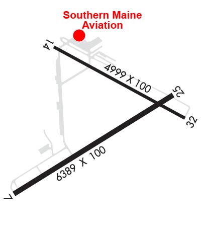 Airport Diagram might not be current. | |
| Facility Name: | SANFORD SEACOAST RGNL |
| City Name: | SANFORD |
| County: | YORK |
| State abbrev: | ME |
| State Name: | MAINE |
| Ownership: | PUBLICLY OWNED |
| Use: | OPEN TO THE PUBLIC |
| Owner's Name: | CITY OF SANFORD |
| Address: | 919 MAIN ST |
| SANFORD, ME 04073 | |
| Owner's Phone: | (207) 324-9173 |
| Manager's Name: | M. ALLISON NAVIA |
| Address: | 9 PRESIDENTIAL LN |
| SANFORD, ME 04073 | |
| Phone: | 207-324-3172 |
| FAA Region: | NEW ENGLAND |
| FAA Field Office: | NONE |

| Date | Sunrise | Sunset |
|---|---|---|
| 06/12/26 Friday | 5:02 | 20:24 |
| 06/13/26 Saturday | 5:02 | 20:24 |
| 06/14/26 Sunday | 5:02 | 20:25 |
| 06/15/26 Monday | 5:02 | 20:25 |
| 06/16/26 Tuesday | 5:02 | 20:25 |
| 06/17/26 Wednesday | 5:02 | 20:26 |
| 06/18/26 Thursday | 5:02 | 20:26 |
| 06/19/26 Friday | 5:02 | 20:26 |
| 06/20/26 Saturday | 5:02 | 20:27 |
| 06/21/26 Sunday | 5:02 | 20:27 |
| 06/22/26 Monday | 5:02 | 20:27 |
| 06/23/26 Tuesday | 5:03 | 20:27 |
| 06/24/26 Wednesday | 5:03 | 20:27 |
| 06/25/26 Thursday | 5:03 | 20:27 |
| Airport Attendance Schedule | OCT-MAY 7 Days A Week 0700-1700, JUN-SEPT 7 Days A Week 0700-1900 |
| Airport Status | OPERATIONAL (This Status can change at any time - please check NOTAMS) |
| Airport Lighting Schedule | ACTVT ODALS RWY 25; REIL RWY 07; PAPI RWY 07 & 25; HIRL 07/25; MIRL 14/32; TWY LGTS - CTAF. TWY LGTS INOP DALGT HRS. |
| Airport Storage Available | Tie Downs, Hanger |
| Extra Services Available | Air Ambulance, Flight Instruction, Aircraft Rental, Annual Surveying |
| Wind Indicator | YES - (lighted) |
| Control Tower | NO |
| CTAF Frequency | 123.075 |
| Unicom Frequency | 123.075 |
| Rotating Beacon Color | WG |
| Segmented Circle | YES |
| Landing Fee | NO |
| Airport Inspected | STATE - performed by PRIVATE CONTRACT PERSONNEL |
| Inspection Date | 08/14/2023 |
| Type of Fuel Available | Grade 100LL, JET A (freeze point -40C)MOGAS |
| Airframe Repair Service | MAJOR |
| Power Plant Repair Service | MAJOR |
| Latitude | N4323.6 |
| Longitude | W07042.5 (ESTIMATED) |
| Arpt Elevation | 244ft (SURVEYED) |
| Magnetic Variation | 17W |
| 4 miles SE | of SANFORD |
| Traffic Pattern Altitude | |
| Sectional Chart | NEW YORK |
| Operations (Reported) | Yearly | Avg. Daily |
|---|---|---|
| General Aviation Transient | 0 | 0 |
| General Aviation Local | 0 | 0 |
| Air Taxi | 0 | 0 |
| Commerical | 0 | 0 |
| Commuter | 0 | 0 |
| Military | 0 | 0 |
| Aircraft based on Field | |
|---|---|
| General Aviation Singles | 0 |
| General Aviation Multi | 0 |
| Jet Aircraft | 0 |
| General Aviation Helicopters | 0 |
| Military Aircraft | 0 |
| Gliders | 0 |
| Ultralights | 0 |
| FSS on field | NO |
| FSS tie-in | BANGOR |
| FSS Phone | 1-800-WX-BRIEF |
| Who issues Notams | SFM |
| Notam D service at airport | YES |
| ARTCC Name | BOSTON |
| Airport Certification | |
| Aircraft Rescue & Firefighting Index | None |
| Airport of Entry | No |
| Custom Landing Rights | No |
| Joint Civil/Military | No |
| Military Landing rights | YES |
| NATIONAL PLAN OF INTEGRATED AIRPORT SYSTEMS (NPIAS) |
| GRANT AGREEMENTS UNDER FAAP/ADAP/AIP |
| SURPLUS PROPERTY AGREEMENT UNDER PUBLIC LAW 289 |
| SURPLUS PROPERTY AGREEMENT UNDER REGULATION 16-WAA |
| AGREEMENT UNDER DLAND OR DCLA HAS EXPIRED. |
| ASSURANCES PURSUANT TO TITLE VI, CIVIL RIGHTS ACT OF 1964 |
| WILDLIFE ON & INVOF ARPT. |
| HIGH VOL FIXED AND ROTARY WING FLT TRNG IN VCNTY. |
| CALM WIND PREFERRED RWY 32. |
| 24 HR FUEL AVBL WITH MAJOR CREDIT CARD FOR 100LL, A & MOGAS. |
| CONDS NOT MNT DLY 1600-0700 EST. |
| FBO AFT HRS CALL-OUT FEE - 207-324-8919. |
| FOR CD WHEN APCH CLSD CTC BOSTON ARTCC AT 603-879-6859. |
Airport Communications & Frequencies:
| |||||||||||||||||||
| Runway: 07 | Runway: 25 | ||
| Mag heading: | 75° | Mag heading: | 255° |
| Rwy Slope: | -.13% Down | Rwy Slope: | .13% Up |
| Approach: | ILS | Approach: | |
| Pattern: | Left Traffic | Pattern: | Left Traffic |
| Markings: | PRECISION INSTRUMENT | Markings: | NONPRECISION INSTRUMENT |
| Marking Condition: | GOOD | Marking Condition: | GOOD |
| Arresting Dev: | Arresting Dev: | ||
| Lat & Long: | N4323.2 W07043.2 | Lat. & Long.: | N4323.8 W07042.0 |
| Elev: | 240.5 ft. MSL | Elev: | 232.1 ft. MSL |
| TCH: | 53 ft. AGL | TCH: | 47 ft. AGL |
| Visual Glide Path: | 3.00 degrees | Visual Glide Path: | 3.00 degrees |
| Displaced Threshold: | No | Displaced Threshold: | 388 feet |
| Touchdown Zone: | YES | Touchdown Zone: | YES |
| Touchdown Elev.: | 240.6 feet | Touchdown Elev.: | 234.7 feet |
| Visual Glide Slope: | 4-Light PAPI on LEFT side of Runway | Visual Glide Slope: | 4-Light PAPI on LEFT side of Runway |
| RVR Equipment: | RVR Equipment: | ||
| RVV Equipment: | NO | RVV Equipment: | NO |
| Approach Lights: | Approach Lights: | ODALS - omnidirectional approach lighting system | |
| REIL: | YES | REIL: | NO |
| Centerline Lights: | NO | Centerline Lights: | NO |
| Touchdown lights: | NO | Touchdown lights: | NO |
| Runway Category: | Precision Instrument Runway | Runway Category: | Runway with a Non-precision Approach having visibility minimums greater than 3/4 mile |
| Declared Distances: | Declared Distances: | ||
| Obstructions: | TREE | Obstructions: | PLINE |
| Marked: | NOT Marked/Lighted | Marked: | NOT Marked/Lighted |
| Clearance slope: | 29:1; APCH RATIO 49:1 AT DTHR. | Clearance slope: | 27:1 |
| Obstruction height: | 30 feet AGL | Obstruction height: | 18 feet AGL |
| Dist. from runway: | 1074 feet | Dist. from runway: | 695 feet |
| Centerline offset: | 278 left of centerline | Centerline offset: | 460 feet right of centerline |
| Comments: | Comments: |
| Runway: 14 | Runway: 32 | ||
| Mag heading: | 136° | Mag heading: | 316° |
| Rwy Slope: | -.27% Down | Rwy Slope: | .27% Up |
| Approach: | Approach: | ||
| Pattern: | Left Traffic | Pattern: | Left Traffic |
| Markings: | BASIC | Markings: | BASIC |
| Marking Condition: | GOOD | Marking Condition: | GOOD |
| Arresting Dev: | Arresting Dev: | ||
| Lat & Long: | N4324.0 W07042.9 | Lat. & Long.: | N4323.6 W07041.9 |
| Elev: | 244.0 ft. MSL | Elev: | 230.7 ft. MSL |
| TCH: | 21 ft. AGL | TCH: | 34 ft. AGL |
| Visual Glide Path: | 4.00 degrees | Visual Glide Path: | 3.00 degrees |
| Displaced Threshold: | 885 feet | Displaced Threshold: | No |
| Touchdown Zone: | YES | Touchdown Zone: | YES |
| Touchdown Elev.: | 241.8 feet | Touchdown Elev.: | 238.9 feet |
| Visual Glide Slope: | 4-Light PAPI on LEFT side of Runway | Visual Glide Slope: | 4-Light PAPI on LEFT side of Runway |
| RVR Equipment: | RVR Equipment: | ||
| RVV Equipment: | NO | RVV Equipment: | NO |
| Approach Lights: | Approach Lights: | ||
| REIL: | NO | REIL: | NO |
| Centerline Lights: | NO | Centerline Lights: | NO |
| Touchdown lights: | NO | Touchdown lights: | NO |
| Runway Category: | Runway with a Visual Approach | Runway Category: | Runway with a Non-precision Approach |
| Declared Distances: | Declared Distances: | ||
| Obstructions: | TREE | Obstructions: | |
| Marked: | NOT Marked/Lighted | Marked: | |
| Clearance slope: | 4:1; APCH RATIO 20:1 AT DTHR. | Clearance slope: | 20:1 |
| Obstruction height: | 68 feet AGL | Obstruction height: | |
| Dist. from runway: | 516 feet | Dist. from runway: | |
| Centerline offset: | 120 left of centerline | Centerline offset: | |
| Comments: | Comments: |
Thanks for using FltPlan.com
all rights reserved © 1999-2026 by Flight Plan LLC