
| FELTS FIELD SPOKANE WA |
| |
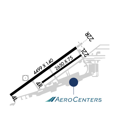
| Lat: N 4741.0 Long: W 11719.3 Elev: 1957 Var: -16 Longest Runway: 4499 | ||
| Clr Del: 121.7 TWR CLD Dept. ATIS: 120.55 Arr. ATIS: 120.55 Ground: 121.7 Tower: 132.5 | ||
| ||||||||||||||||||||||||||||||||||||||||||||||||||||||||||||||||||||
| ||||||||||||||||||||||||||||||||||||||||||||||||||||||||||||||||||||
| ||||||||||||||||||||||||||||||||||||||||||||||||||||||||||||||||||||
| Rwy | Rwy | |||||||
| 6000x100 | 6000' | 6000x100 | 6000' | |||||
| 4499x140 | 4499' | 4499x140 | 4499' | 111.70 - 221° | ||||
| 2650x75 | 2650' | 2650x75 | 2650' | |||||
| Runway ID | Single Wheel | Double Wheel | Double Tandem Wheel | Dual Double Wheel |
| 03W/21W | N/A | N/A | N/A | N/A |
| 04L/22R | 30,000 | N/A | N/A | N/A |
| 04R/22L | 30,000 | N/A | N/A | N/A |
| These numbers are Advisory and are not limits. The Airport Manager should have more accurate Weight Limits | ||||
 Airport Diagram might not be current. | |
| Facility Name: | FELTS FLD |
| City Name: | SPOKANE |
| County: | SPOKANE |
| State abbrev: | WA |
| State Name: | WASHINGTON |
| Ownership: | PUBLICLY OWNED |
| Use: | OPEN TO THE PUBLIC |
| Owner's Name: | SPOKANE CITY-COUNTY |
| Address: | AIRPORT BOARD, 9000 W. AIRPORT DRIVE |
| SPOKANE, WA 99224 | |
| Owner's Phone: | 509-455-6455 |
| Manager's Name: | DAVID HARING |
| Address: | 9000 W. AIRPORT DRIVE, SUITE 204 |
| SPOKANE, WA 99224 | |
| Phone: | 509-455-6455 |
| FAA Region: | NORTHWEST MOUNTAIN |
| FAA Field Office: | SEA |
| Date | Sunrise | Sunset |
|---|---|---|
| 06/08/26 Monday | 4:52 | 20:45 |
| 06/09/26 Tuesday | 4:52 | 20:46 |
| 06/10/26 Wednesday | 4:51 | 20:46 |
| 06/11/26 Thursday | 4:51 | 20:47 |
| 06/12/26 Friday | 4:51 | 20:48 |
| 06/13/26 Saturday | 4:51 | 20:48 |
| 06/14/26 Sunday | 4:51 | 20:49 |
| 06/15/26 Monday | 4:51 | 20:49 |
| 06/16/26 Tuesday | 4:51 | 20:50 |
| 06/17/26 Wednesday | 4:51 | 20:50 |
| 06/18/26 Thursday | 4:51 | 20:50 |
| 06/19/26 Friday | 4:51 | 20:51 |
| 06/20/26 Saturday | 4:51 | 20:51 |
| 06/21/26 Sunday | 4:51 | 20:51 |
| Airport Attendance Schedule | 7 Days A Week 0600-2000 |
| Airport Status | OPERATIONAL (This Status can change at any time - please check NOTAMS) |
| Airport Lighting Schedule | WHEN ATCT CLSD ACTVT MIRL RY 04L/22R, MALSR RY 22R AND REIL RY 04L - CTAF. VASI RY 04L & VASI RY 22R OPER CONTINUOUSLY. PAPI RY 22L OPER SR-SS. |
| Airport Storage Available | Tie Downs |
| Extra Services Available | Air Ambulance, Avionics, Charter, Flight Instruction, Aircraft Rental, Aircraft Sales |
| Wind Indicator | YES - (lighted) |
| Control Tower | YES |
| CTAF Frequency | 132.500 |
| Unicom Frequency | 122.950 |
| Rotating Beacon Color | WG |
| Segmented Circle | YES |
| Landing Fee | NO |
| Airport Inspected | STATE - performed by STATE AERONAUTICAL PERSONNEL |
| Inspection Date | 07/17/2024 |
| Type of Fuel Available | Grade 100LL, JET A-1 (icing inhibitor, freeze point -50C) |
| Airframe Repair Service | MAJOR |
| Power Plant Repair Service | MAJOR |
| Latitude | N4741.0 |
| Longitude | W11719.3 (ESTIMATED) |
| Arpt Elevation | 1956ft (SURVEYED) |
| Magnetic Variation | 16E |
| 4 miles NE | of SPOKANE |
| Traffic Pattern Altitude | |
| Sectional Chart | SEATTLE |
| Operations (Reported) | Yearly | Avg. Daily |
|---|---|---|
| General Aviation Transient | 0 | 0 |
| General Aviation Local | 0 | 0 |
| Air Taxi | 0 | 0 |
| Commerical | 0 | 0 |
| Commuter | 0 | 0 |
| Military | 0 | 0 |
| Aircraft based on Field | |
|---|---|
| General Aviation Singles | 0 |
| General Aviation Multi | 0 |
| Jet Aircraft | 0 |
| General Aviation Helicopters | 0 |
| Military Aircraft | 0 |
| Gliders | 0 |
| Ultralights | 0 |
| FSS on field | NO |
| FSS tie-in | SEATTLE |
| FSS Phone | 1-800-WX-BRIEF |
| Who issues Notams | SFF |
| Notam D service at airport | YES |
| ARTCC Name | SEATTLE |
| Airport Certification | |
| Aircraft Rescue & Firefighting Index | None |
| Airport of Entry | No |
| Custom Landing Rights | YES |
| Joint Civil/Military | No |
| Military Landing rights | YES |
| NATIONAL PLAN OF INTEGRATED AIRPORT SYSTEMS (NPIAS) |
| GRANT AGREEMENTS UNDER FAAP/ADAP/AIP |
| ASSURANCES PURSUANT TO TITLE VI, CIVIL RIGHTS ACT OF 1964 |
| AGREEMENT UNDER DLAND OR DCLA HAS EXPIRED. |
| PPR FOR ROTORWING ACFT CONCDUCTING HOVER OPS ABOVE 10 FT AGL IN NON-MOVEMENT AREA CTC ATCT. |
| PORTIONS OF TWY B NOT VISIBLE FM ATCT. |
| FOR CD IF UNA TO CTC ON FSS FREQ, CTC SPOKANE APPROACH AT 509-742-2522. |
| COLD TEMPERATURE AIRPORT. ALTITUDE CORRECTION REQUIRED AT OR BELOW -15C. |
| TWR UNABLE TO PRVD ATC SVC ON PERIMETER TWY DUE TO MOVEMENT OF UNCONTROLLED GROUND TFC. |
| EXTENSIVE BOATING IN AREA OF WATER RY. |
| WATER LVL ON RIVER MAY BE LWRD BY CORPS OF ENGR. WATER AREA ADJ TO ARPT NOT CTLD OR MNTND BY ARPT. WATERWAY ELEV 1910 ESTD. |
| (E94) SAWRS. |
| WATERFOWL AND BIRDS ON & INVOF ARPT. |
| ACFT WITH TAIL HEIGHTS OVER 20 FT MUST CTC ATCT PRIOR TO TAXI. |
| RWY 03W/ 21WWATER RWY ADZY SVC ONLY AREA NOT VSB FM TWR. CTC FELTS TWR 132.5 FOR TFC DATA. |
Airport Communications & Frequencies:
| |||||||||||||||||||||||||||
| Runway: 03W | Runway: 21W | ||
| Mag heading: | N/A | Mag heading: | N/A |
| Approach: | Approach: | ||
| Pattern: | Left Traffic | Pattern: | Right Traffic |
| Markings: | Markings: | ||
| Marking Condition: | Marking Condition: | ||
| Arresting Dev: | Arresting Dev: | ||
| Lat & Long: | Lat. & Long.: | ||
| Elev: | N/A | Elev: | N/A |
| TCH: | TCH: | ||
| Visual Glide Path: | Visual Glide Path: | ||
| Displaced Threshold: | No | Displaced Threshold: | No |
| Touchdown Zone: | NO | Touchdown Zone: | NO |
| Touchdown Elev.: | Touchdown Elev.: | ||
| Visual Glide Slope: | Visual Glide Slope: | ||
| RVR Equipment: | RVR Equipment: | ||
| RVV Equipment: | NO | RVV Equipment: | NO |
| Approach Lights: | Approach Lights: | ||
| REIL: | NO | REIL: | NO |
| Centerline Lights: | NO | Centerline Lights: | NO |
| Touchdown lights: | NO | Touchdown lights: | NO |
| Runway Category: | Runway with a Visual Approach | Runway Category: | Runway with a Visual Approach |
| Declared Distances: | Declared Distances: |
| Runway: 04L | Runway: 22R | ||
| Mag heading: | 38° | Mag heading: | 218° |
| Rwy Slope: | .23% Up | Rwy Slope: | -.23% Down |
| Approach: | Approach: | ILS/DME | |
| Pattern: | Left Traffic | Pattern: | Right Traffic |
| Markings: | NONPRECISION INSTRUMENT | Markings: | PRECISION INSTRUMENT |
| Marking Condition: | GOOD | Marking Condition: | GOOD |
| Arresting Dev: | Arresting Dev: | ||
| Lat & Long: | N4740.8 W11719.9 | Lat. & Long.: | N4741.2 W11719.0 |
| Elev: | 1946.4 ft. MSL | Elev: | 1956.7 ft. MSL |
| TCH: | 50 ft. AGL | TCH: | 44 ft. AGL |
| Visual Glide Path: | 3.00 degrees | Visual Glide Path: | 3.50 degrees |
| Displaced Threshold: | No | Displaced Threshold: | No |
| Touchdown Zone: | YES | Touchdown Zone: | YES |
| Touchdown Elev.: | 1949.0 feet | Touchdown Elev.: | 1956.7 feet |
| Visual Glide Slope: | 2-Box VASI on LEFT side of Runway | Visual Glide Slope: | 2-Box VASI on RIGHT side of Runway |
| RVR Equipment: | RVR Equipment: | ||
| RVV Equipment: | NO | RVV Equipment: | NO |
| Approach Lights: | Approach Lights: | MALSR - 1,400 foot medium intensity approach lighting system with runway alignment indicator lights | |
| REIL: | YES | REIL: | NO |
| Centerline Lights: | NO | Centerline Lights: | NO |
| Touchdown lights: | NO | Touchdown lights: | NO |
| Runway Category: | Runway with a Non-precision Approach having visibility minimums greater than 3/4 mile | Runway Category: | Precision Instrument Runway |
| Declared Distances: | TORA:4499' TODA:4499' ASDA:4499' LDA:4499' | Declared Distances: | TORA:4499' TODA:4499' ASDA:4499' LDA:4499' |
| Obstructions: | Obstructions: | TREE | |
| Marked: | Marked: | NOT Marked/Lighted | |
| Clearance slope: | 34:1 | Clearance slope: | 25:1 |
| Obstruction height: | Obstruction height: | 72 feet AGL | |
| Dist. from runway: | Dist. from runway: | 2045 feet | |
| Centerline offset: | Centerline offset: | 1220 feet left of centerline | |
| Comments: | Comments: |
| Runway: 04R | Runway: 22L | ||
| Mag heading: | 38° | Mag heading: | 218° |
| Rwy Slope: | .13% Up | Rwy Slope: | -.13% Down |
| Approach: | Approach: | ||
| Pattern: | Right Traffic | Pattern: | Left Traffic |
| Markings: | BASIC | Markings: | BASIC |
| Marking Condition: | GOOD | Marking Condition: | GOOD |
| Arresting Dev: | Arresting Dev: | ||
| Lat & Long: | N4740.9 W11719.4 | Lat. & Long.: | N4741.1 W11718.9 |
| Elev: | 1950.3 ft. MSL | Elev: | 1953.7 ft. MSL |
| TCH: | TCH: | 39 ft. AGL | |
| Visual Glide Path: | Visual Glide Path: | 3.80 degrees | |
| Displaced Threshold: | No | Displaced Threshold: | No |
| Touchdown Zone: | YES | Touchdown Zone: | YES |
| Touchdown Elev.: | 1954.1 feet | Touchdown Elev.: | 1953.1 feet |
| Visual Glide Slope: | Visual Glide Slope: | 4-Light PAPI on LEFT side of Runway; PAPI UNUSBL BYD 5 DEGS RIGHT SIDE OF CNTRLN. | |
| RVR Equipment: | RVR Equipment: | ||
| RVV Equipment: | NO | RVV Equipment: | NO |
| Approach Lights: | Approach Lights: | ||
| REIL: | NO | REIL: | NO |
| Centerline Lights: | NO | Centerline Lights: | NO |
| Touchdown lights: | NO | Touchdown lights: | NO |
| Runway Category: | Runway with a Visual Approach | Runway Category: | Runway with a Visual Approach |
| Declared Distances: | TORA:2650' TODA:2650' ASDA:2650' LDA:2650' | Declared Distances: | TORA:2650' TODA:2650' ASDA:2650' LDA:2650' |
| Obstructions: | Obstructions: | TREE | |
| Marked: | Marked: | NOT Marked/Lighted | |
| Clearance slope: | 20:1 | Clearance slope: | 18:1 |
| Obstruction height: | Obstruction height: | 91 feet AGL | |
| Dist. from runway: | Dist. from runway: | 1855 feet | |
| Centerline offset: | Centerline offset: | 280 feet left of centerline | |
| Comments: | Comments: |
Thanks for using FltPlan.com
all rights reserved © 1999-2026 by Flight Plan LLC


