| SEDONA SEDONA AZ |
| |
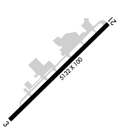
| Lat: N 3450.9 Long: W 11147.3 Elev: 4831 Var: -13 Longest Runway: 5132 | ||
| AWOS: 118.52 CTAF: 123.0 | ||
| ||||||||||||||||||||||||||||||||||||||||||||||||||||||||||||||||||||
| ||||||||||||||||||||||||||||||||||||||||||||||||||||||||||||||||||||
| ||||||||||||||||||||||||||||||||||||||||||||||||||||||||||||||||||||
| Rwy | Rwy | |||||||
| 5132x100 | 5132' | 5132x100 | 5132' | |||||
| Runway ID | Single Wheel | Double Wheel | Double Tandem Wheel | Dual Double Wheel |
| 03/21 | 15,000 | 30,000 | N/A | N/A |
| H1 | N/A | N/A | N/A | N/A |
| These numbers are Advisory and are not limits. The Airport Manager should have more accurate Weight Limits | ||||
 Airport Diagram might not be current. | |
| Facility Name: | SEDONA |
| City Name: | SEDONA |
| County: | YAVAPAI |
| State abbrev: | AZ |
| State Name: | ARIZONA |
| Ownership: | PUBLICLY OWNED |
| Use: | OPEN TO THE PUBLIC |
| Owner's Name: | YAVAPAI COUNTY |
| Address: | 1015 FAIR ST. |
| PRESCOTT, AZ 86305 | |
| Owner's Phone: | (928) 771-3200 |
| Manager's Name: | EDWARD A. ROSE |
| Address: | 235 AIR TERMINAL DRIVE |
| SEDONA, AZ 86336 | |
| Phone: | 928-282-4487; EMERG 928-300-3304. |
| FAA Region: | WESTERN-PACIFIC |
| FAA Field Office: | PHX |
| Date | Sunrise | Sunset |
|---|---|---|
| 04/24/24 Wednesday | 5:43 | 19:07 |
| 04/25/24 Thursday | 5:42 | 19:08 |
| 04/26/24 Friday | 5:41 | 19:09 |
| 04/27/24 Saturday | 5:40 | 19:10 |
| 04/28/24 Sunday | 5:39 | 19:11 |
| 04/29/24 Monday | 5:38 | 19:11 |
| 04/30/24 Tuesday | 5:37 | 19:12 |
| 05/01/24 Wednesday | 5:36 | 19:13 |
| 05/02/24 Thursday | 5:35 | 19:14 |
| 05/03/24 Friday | 5:34 | 19:15 |
| 05/04/24 Saturday | 5:33 | 19:15 |
| 05/05/24 Sunday | 5:32 | 19:16 |
| 05/06/24 Monday | 5:31 | 19:17 |
| 05/07/24 Tuesday | 5:30 | 19:18 |
| Airport Attendance Schedule | MAY-SEP 7 Days A Week 0700-1800, OCT-APR 7 Days A Week 0700-1700 |
| Airport Status | OPERATIONAL (This Status can change at any time - please check NOTAMS) |
| Airport Lighting Schedule | ACTVT REIL RWY 03 & 21; PAPI RWY 03 & 21; MIRL RWY 03/21 - CTAF. |
| Airport Storage Available | Tie Downs, Hanger |
| Extra Services Available | Charter |
| Wind Indicator | YES - (lighted) |
| Control Tower | NO |
| CTAF Frequency | 123.000 |
| Unicom Frequency | 123.000 |
| Rotating Beacon Color | WG |
| Segmented Circle | YES |
| Landing Fee | YES |
| Airport Inspected | STATE - performed by PRIVATE CONTRACT PERSONNEL |
| Inspection Date | 05/11/2022 |
| Type of Fuel Available | Grade 100LL, JET A (freeze point -40C); -10FUEL OPS TIL 30 MIN PRIOR TO CLOSING; CALL OUT FEE AFT HR. |
| Airframe Repair Service | MINOR |
| Power Plant Repair Service | MINOR |
| Latitude | N3450.9 |
| Longitude | W11147.3 (ESTIMATED) |
| Arpt Elevation | 4830ft (SURVEYED) |
| Magnetic Variation | 13E |
| 2 miles SW | of SEDONA |
| Traffic Pattern Altitude | TPA FOR PROPELLER ACFT 1173 AGL, JET ACFT 2173 AGL. |
| Sectional Chart | PHOENIX |
| Operations (Reported) | Yearly | Avg. Daily |
|---|---|---|
| General Aviation Transient | 14000 | 38 |
| General Aviation Local | 8750 | 24 |
| Air Taxi | 10850 | 30 |
| Commerical | 0 | 0 |
| Commuter | 0 | 0 |
| Military | 1400 | 4 |
| Aircraft based on Field | |
|---|---|
| General Aviation Singles | 53 |
| General Aviation Multi | 6 |
| Jet Aircraft | 0 |
| General Aviation Helicopters | 4 |
| Military Aircraft | 0 |
| Gliders | 1 |
| Ultralights | 0 |
| FSS on field | NO |
| FSS tie-in | PRESCOTT |
| FSS Phone | 1-800-WX-BRIEF |
| Who issues Notams | SEZ |
| Notam D service at airport | YES |
| ARTCC Name | ALBUQUERQUE |
| Airport Certification | |
| Aircraft Rescue & Firefighting Index | None |
| Airport of Entry | No |
| Custom Landing Rights | No |
| Joint Civil/Military | No |
| Military Landing rights | YES |
| NATIONAL PLAN OF INTEGRATED AIRPORT SYSTEMS (NPIAS) |
| GRANT AGREEMENTS UNDER FAAP/ADAP/AIP |
| CONVEYANCE UNDER SCETION 16, FEDERAL AIRPORT ACT OF 1946 OR SECTION 23, AIRPORT AND AIRWAY DEVELOPMENT ACT OF 1970 |
| ASSURANCES PURSUANT TO TITLE VI, CIVIL RIGHTS ACT OF 1964 |
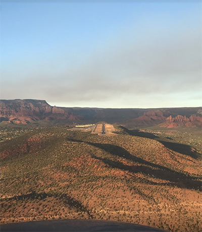
| ARPT ON 500 FT MESA. |
| TURB & WILDLIFE ON & INVOF ARPT. |
| FOR CD CTC PHOENIX APCH AT 602-306-2565. |
| LNDG FEE FOR TURBINE ACFT WO FUEL PURCHASE. OVERNIGHT TSNT FEE. |
| HOP FM HELI S & W OF RWY; HOP RSTRD TO HELI ADJ TO TWY INTXN A7 SW MAIN TRML BLDG. |
| NOISE ABATEMENT PROC IN EFCT; SCENIC FLT BLW 6500 FT MSL NA. |
| RWY 03/2 1 RWY 03 CALM WIND RWY. |
| RWY 03 UPHILL SLOPE. |
| RWY 21 LNDG DURG STRONG SW WIND EXP STRONG DOWN DRAFT NE OF AOR. |
Airport Communications & Frequencies:
| |||||||||||||||||
| Runway: 03 | Runway: 21 | ||
| Mag heading: | 32° | Mag heading: | 212° |
| Rwy Slope: | 1.83% Up | Rwy Slope: | -1.83% Down |
| Approach: | Approach: | ||
| Pattern: | Left Traffic | Pattern: | Left Traffic |
| Markings: | NONPRECISION INSTRUMENT | Markings: | BASIC |
| Marking Condition: | GOOD | Marking Condition: | GOOD |
| Arresting Dev: | Arresting Dev: | ||
| Lat & Long: | N3450.6 W11147.7 | Lat. & Long.: | N3451.2 W11146.9 |
| Elev: | 4736.3 ft. MSL | Elev: | 4830.3 ft. MSL |
| TCH: | 44 ft. AGL | TCH: | 49 ft. AGL |
| Visual Glide Path: | 3.00 degrees | Visual Glide Path: | 3.50 degrees |
| Displaced Threshold: | No | Displaced Threshold: | No |
| Touchdown Zone: | YES | Touchdown Zone: | YES |
| Touchdown Elev.: | 4793.1 feet | Touchdown Elev.: | 4830.5 feet |
| Visual Glide Slope: | 4-Light PAPI on LEFT side of Runway | Visual Glide Slope: | 4-Light PAPI on LEFT side of Runway; PAPI UNUSBL BYD 2.0 NM. |
| RVR Equipment: | RVR Equipment: | ||
| RVV Equipment: | NO | RVV Equipment: | NO |
| Approach Lights: | Approach Lights: | ||
| REIL: | YES | REIL: | YES |
| Centerline Lights: | NO | Centerline Lights: | NO |
| Touchdown lights: | NO | Touchdown lights: | NO |
| Runway Category: | Runway with a Non-precision Approach having visibility minimums greater than 3/4 mile | Runway Category: | Runway with a Visual Approach |
| Declared Distances: | Declared Distances: | ||
| Obstructions: | Obstructions: | FENCE | |
| Marked: | Marked: | NOT Marked/Lighted | |
| Clearance slope: | 50:1 | Clearance slope: | |
| Obstruction height: | Obstruction height: | 8 feet AGL | |
| Dist. from runway: | Dist. from runway: | 201 feet | |
| Centerline offset: | Centerline offset: | 70 feet left of centerline | |
| Comments: | 1 FT FENCE POST 125 FT FM THR 75 FT L OF CNTRLN LGTD SS-SR. | Comments: | 8 FT FENCE 100-200 FT FM THR 90-125 FT L OF CNTRLN LGTD SS-SR. |
Thanks for using FltPlan.com
all rights reserved © 1999-2024 by Flight Plan LLC