
| SOUTHEASTERN AVIATION SERVICES SELMA AL |
| |
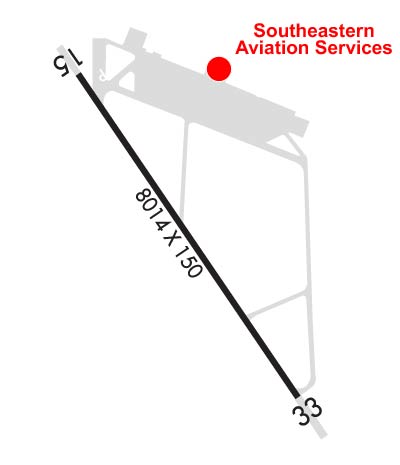
| Lat: N 3220.6 Long: W 08659.3 Elev: 166 Var: +03 Longest Runway: 8014 | ||
| AWOS: 119.15 CTAF: 122.7 | ||
| ||||||||||||||||||||||||||||||
| ||||||||||||||||||||||||||||||
| ||||||||||||||||||||||||||||||
| Rwy | Rwy | |||||||
| 8014x150 | 8014' | 8014x150 | 8014' | 110.50 - 328° | ||||
| Runway ID | Single Wheel | Double Wheel | Double Tandem Wheel | Dual Double Wheel |
| 15/33 | 33,000 | 54,000 | N/A | N/A |
| These numbers are Advisory and are not limits. The Airport Manager should have more accurate Weight Limits | ||||
 Airport Diagram might not be current. | |
| Facility Name: | CRAIG FLD |
| City Name: | SELMA |
| County: | DALLAS |
| State abbrev: | AL |
| State Name: | ALABAMA |
| Ownership: | PUBLICLY OWNED |
| Use: | OPEN TO THE PUBLIC |
| Owner's Name: | CRAIG FLD ARPT & IND AUTH; JAMES CORRIGAN, EXECUTIVE DIRECTOR |
| Address: | PO BOX 1421 |
| SELMA, AL 36702 | |
| Owner's Phone: | 334-874-7419 |
| Manager's Name: | DUSTIN BECK |
| Address: | CRAIG FIELD INDUSTRIAL, HANGAR 202, AVENUE J |
| SELMA, AL 36701 | |
| Phone: | (334) 875-2189; ALT 334-874-7419. |
| FAA Region: | SOUTHERN |
| FAA Field Office: | JAN |

| Date | Sunrise | Sunset |
|---|---|---|
| 09/24/21 Friday | 6:37 | 18:42 |
| 09/25/21 Saturday | 6:38 | 18:41 |
| 09/26/21 Sunday | 6:39 | 18:40 |
| 09/27/21 Monday | 6:39 | 18:38 |
| 09/28/21 Tuesday | 6:40 | 18:37 |
| 09/29/21 Wednesday | 6:40 | 18:36 |
| 09/30/21 Thursday | 6:41 | 18:34 |
| 10/01/21 Friday | 6:42 | 18:33 |
| 10/02/21 Saturday | 6:42 | 18:32 |
| 10/03/21 Sunday | 6:43 | 18:30 |
| 10/04/21 Monday | 6:44 | 18:29 |
| 10/05/21 Tuesday | 6:44 | 18:28 |
| 10/06/21 Wednesday | 6:45 | 18:27 |
| 10/07/21 Thursday | 6:46 | 18:25 |
| Airport Attendance Schedule | 7 Days A Week 0800-1800 |
| Airport Status | OPERATIONAL (This Status can change at any time - please check NOTAMS) |
| Airport Lighting Schedule | ACTVT MALS RWY 33; PAPI RWY 15/33 AND HIRL RWY 15/33 - CTAF. |
| Airport Storage Available | Tie Downs, Hanger |
| Extra Services Available | Flight Instruction |
| Wind Indicator | YES - (lighted) |
| Control Tower | NO |
| CTAF Frequency | 122.700 |
| Unicom Frequency | 122.700 |
| Rotating Beacon Color | CLEAR-GREEN (Light Land Airport) |
| Segmented Circle | NO |
| Landing Fee | NO |
| Airport Inspected | STATE - performed by STATE AERONAUTICAL PERSONNEL |
| Inspection Date | 10/09/2019 |
| Type of Fuel Available | Grade 100LL, JET A (freeze point -40C); -1024HR 100LL AND JET A AVBL CALL 334-651-1511 AFT HRS. |
| Airframe Repair Service | MAJOR |
| Power Plant Repair Service | MAJOR |
| Latitude | N3220.6 |
| Longitude | W08659.3 (ESTIMATED) |
| Arpt Elevation | 166ft (SURVEYED) |
| Magnetic Variation | 03W |
| 4 miles SE | of SELMA |
| Traffic Pattern Altitude | |
| Sectional Chart | ATLANTA |
| Operations (Reported) | Yearly | Avg. Daily |
|---|---|---|
| General Aviation Transient | 32000 | 88 |
| General Aviation Local | 2300 | 6 |
| Air Taxi | 250 | 1 |
| Commerical | 0 | 0 |
| Commuter | 0 | 0 |
| Military | 4000 | 11 |
| Aircraft based on Field | |
|---|---|
| General Aviation Singles | 10 |
| General Aviation Multi | 3 |
| Jet Aircraft | 0 |
| General Aviation Helicopters | 0 |
| Military Aircraft | 0 |
| Gliders | 0 |
| Ultralights | 0 |
| FSS on field | NO |
| FSS tie-in | ANNISTON |
| FSS Phone | 1-800-WX-BRIEF |
| Who issues Notams | ANB |
| Notam D service at airport | YES |
| ARTCC Name | ATLANTA |
| Airport Certification | |
| Aircraft Rescue & Firefighting Index | None |
| Airport of Entry | No |
| Custom Landing Rights | No |
| Joint Civil/Military | No |
| Military Landing rights | YES |
| NATIONAL PLAN OF INTEGRATED AIRPORT SYSTEMS (NPIAS) |
| GRANT AGREEMENTS UNDER FAAP/ADAP/AIP |
| SURPLUS PROPERTY AGREEMENT UNDER PUBLIC LAW 289 |
| OBLIGATIONS ASSUMED BY TRANSFER |
| ASSURANCES PURSUANT TO TITLE VI, CIVIL RIGHTS ACT OF 1964 |
| FOR CD IF UNA TO CTC ON FSS FREQ, CTC DANNELLY APCH AT 334-284-4575, WHEN ATCT CLSD CTC ATLANTA ARTCC AT 770-210-7692. |
Airport Communications & Frequencies:
| |||||||||||||||||
| Runway: 15 | Runway: 33 | ||
| Mag heading: | 149° | Mag heading: | 329° |
| Rwy Slope: | -.01% Down | Rwy Slope: | .01% Up |
| Approach: | Approach: | ILS/DME | |
| Pattern: | Left Traffic | Pattern: | Left Traffic |
| Markings: | PRECISION INSTRUMENT | Markings: | PRECISION INSTRUMENT |
| Marking Condition: | FAIR | Marking Condition: | FAIR |
| Arresting Dev: | Arresting Dev: | ||
| Lat & Long: | N3221.2 W08659.7 | Lat. & Long.: | N3220.1 W08658.8 |
| Elev: | 166.2 ft. MSL | Elev: | 165.1 ft. MSL |
| TCH: | 50 ft. AGL | TCH: | 56 ft. AGL |
| Visual Glide Path: | 3.00 degrees | Visual Glide Path: | 3.00 degrees |
| Displaced Threshold: | No | Displaced Threshold: | No |
| Touchdown Zone: | YES | Touchdown Zone: | YES |
| Touchdown Elev.: | 166.2 feet | Touchdown Elev.: | 165.3 feet |
| Visual Glide Slope: | 4-Light PAPI on LEFT side of Runway | Visual Glide Slope: | 4-Light PAPI on LEFT side of Runway |
| RVR Equipment: | RVR Equipment: | ||
| RVV Equipment: | NO | RVV Equipment: | NO |
| Approach Lights: | Approach Lights: | MALS - 1,400 foot medium intensity approach lighting system | |
| REIL: | NO | REIL: | NO |
| Centerline Lights: | NO | Centerline Lights: | NO |
| Touchdown lights: | NO | Touchdown lights: | NO |
| Runway Category: | Runway with a Non-precision Approach having visibility minimums greater than 3/4 mile | Runway Category: | Precision Instrument Runway |
| Declared Distances: | Declared Distances: | ||
| Obstructions: | TREES | Obstructions: | TREES |
| Marked: | NOT Marked/Lighted | Marked: | NOT Marked/Lighted |
| Clearance slope: | 27:1 | Clearance slope: | 34:1 |
| Obstruction height: | 34 feet AGL | Obstruction height: | 70 feet AGL |
| Dist. from runway: | 1146 feet | Dist. from runway: | 2631 feet |
| Centerline offset: | 155 left of centerline | Centerline offset: | 263 feet right of centerline |
| Comments: | Comments: |
Thanks for using FltPlan.com
all rights reserved © 1999-2021 by Flight Plan LLC

