
| GILLESPIE FIELD SAN DIEGO/EL CAJON CA |
| |
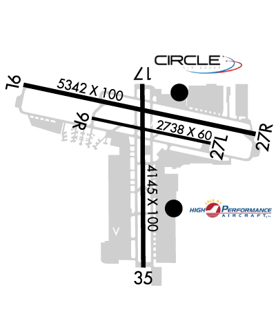
| Lat: N 3249.6 Long: W 11658.3 Elev: 388 Var: -13 Longest Runway: 5342 | ||
| Clr Del: 125.1 Dept. ATIS: 125.45 Arr. ATIS: 125.45 AWOS: 125.45 Ground: 121.7 Tower: 120.7/123.8 | ||
| |||||||||||||||||||||||||||||||||||||||
| |||||||||||||||||||||||||||||||||||||||
| |||||||||||||||||||||||||||||||||||||||
| |||||||||||||||||||||||||||||||||||||||
| |||||||||||||||||||||||||||||||||||||||
| |||||||||||||||||||||||||||||||||||||||
| |||||||||||||||||||||||||||||||||||||||
| Rwy | Rwy | |||||||
| 5342x100 | 5342' | 5342x100 | 4636' | 110.50 - 269° | ||||
| 2738x60 | 2738' | 2738x60 | 2738' | |||||
| 4145x100 | 3695' | 4145x100 | 3460' | |||||
| Runway ID | Single Wheel | Double Wheel | Double Tandem Wheel | Dual Double Wheel |
| 09L/27R | 90,000 | 120,000 | 200,000 | N/A |
| 09R/27L | 12,000 | N/A | N/A | N/A |
| 17/35 | 58,000 | 106,000 | 195,000 | N/A |
| These numbers are Advisory and are not limits. The Airport Manager should have more accurate Weight Limits | ||||
 Airport Diagram might not be current. | |
| Facility Name: | GILLESPIE FLD |
| City Name: | SAN DIEGO/EL CAJON |
| County: | SAN DIEGO |
| State abbrev: | CA |
| State Name: | CALIFORNIA |
| Ownership: | PUBLICLY OWNED |
| Use: | OPEN TO THE PUBLIC |
| Owner's Name: | COUNTY OF SAN DIEGO |
| Address: | DEPT PUBLIC WORKS-AIRPORTS, 1960 JOE CROSSON DR |
| EL CAJON, CA 92020-1236 | |
| Owner's Phone: | 619-956-4800 |
| Manager's Name: | CATHE JOHNSON; ARPT OPNS, 619-956-4800 |
| Address: | GILLESPIE FIELD AIRPORT, 1960 JOE CROSSON DR |
| EL CAJON, CA 92020-1236 | |
| Phone: | (619) 956-4805 |
| FAA Region: | WESTERN-PACIFIC |
| FAA Field Office: | LAX |
| Date | Sunrise | Sunset |
|---|---|---|
| 09/24/21 Friday | 6:37 | 18:42 |
| 09/25/21 Saturday | 6:38 | 18:41 |
| 09/26/21 Sunday | 6:39 | 18:39 |
| 09/27/21 Monday | 6:39 | 18:38 |
| 09/28/21 Tuesday | 6:40 | 18:37 |
| 09/29/21 Wednesday | 6:41 | 18:35 |
| 09/30/21 Thursday | 6:41 | 18:34 |
| 10/01/21 Friday | 6:42 | 18:33 |
| 10/02/21 Saturday | 6:43 | 18:31 |
| 10/03/21 Sunday | 6:43 | 18:30 |
| 10/04/21 Monday | 6:44 | 18:29 |
| 10/05/21 Tuesday | 6:45 | 18:27 |
| 10/06/21 Wednesday | 6:45 | 18:26 |
| 10/07/21 Thursday | 6:46 | 18:25 |
| Airport Attendance Schedule | 7 Days A Week 0700-2100 |
| Airport Status | OPERATIONAL (This Status can change at any time - please check NOTAMS) |
| Airport Lighting Schedule | WHEN ATCT CLSD ACTVT VASI RWY 17, 35, & 09L; PAPI & REIL RWY 27R; MIRL RWY 09L/27R & RY 17/35 - CTAF. |
| Airport Storage Available | Tie Downs |
| Extra Services Available | Air Freight, Air Ambulance, Avionics, Charter, Flight Instruction, Aircraft Rental, Aircraft Sales, Annual Surveying |
| Wind Indicator | YES - (lighted) |
| Control Tower | YES |
| CTAF Frequency | 120.700 |
| Unicom Frequency | |
| Rotating Beacon Color | CLEAR-GREEN (Light Land Airport) |
| Segmented Circle | YES |
| Landing Fee | NO |
| Airport Inspected | STATE - performed by STATE AERONAUTICAL PERSONNEL |
| Inspection Date | 06/08/2021 |
| Type of Fuel Available | Grade 100LL, JET A (freeze point -40C); -10FOR FUEL SVC OR ASSISTANCE DRG BUS HRS, CTC (619) 449-0611, (619) 448-5991, OR (619) 981-5000. 100LL SELF SVC AVBL 24 HRS. |
| Airframe Repair Service | MAJOR |
| Power Plant Repair Service | MAJOR |
| Latitude | N3249.6 |
| Longitude | W11658.3 (ESTIMATED) |
| Arpt Elevation | 387ft (SURVEYED) |
| Magnetic Variation | 13E |
| 10 miles NE | of SAN DIEGO/EL CAJON |
| Traffic Pattern Altitude | |
| Sectional Chart | LOS ANGELES |
| Operations (Reported) | Yearly | Avg. Daily |
|---|---|---|
| General Aviation Transient | 60952 | 167 |
| General Aviation Local | 120248 | 329 |
| Air Taxi | 786 | 2 |
| Commerical | 0 | 0 |
| Commuter | 0 | 0 |
| Military | 219 | 1 |
| Aircraft based on Field | |
|---|---|
| General Aviation Singles | 416 |
| General Aviation Multi | 32 |
| Jet Aircraft | 24 |
| General Aviation Helicopters | 31 |
| Military Aircraft | 0 |
| Gliders | 1 |
| Ultralights | 0 |
| FSS on field | NO |
| FSS tie-in | SAN DIEGO |
| FSS Phone | 1-800-WX-BRIEF |
| Who issues Notams | SEE |
| Notam D service at airport | YES |
| ARTCC Name | LOS ANGELES |
| Airport Certification | |
| Aircraft Rescue & Firefighting Index | None |
| Airport of Entry | No |
| Custom Landing Rights | No |
| Joint Civil/Military | No |
| Military Landing rights | YES |
| NATIONAL PLAN OF INTEGRATED AIRPORT SYSTEMS (NPIAS) |
| GRANT AGREEMENTS UNDER FAAP/ADAP/AIP |
| SURPLUS PROPERTY AGREEMENT UNDER PUBLIC LAW 289 |
| ASSURANCES PURSUANT TO TITLE VI, CIVIL RIGHTS ACT OF 1964 |
| THIS AIRPORT HAS BEEN SURVEYED BY THE NATIONAL GEODETIC SURVEY. |
| W TRNT RAMP AND PTNS OF TWY DELTA BTN D2 AND W TSTN RAMP NOT VISIBLE FROM ATCT. |
| WHEN TWR CLSD, ACFT MUST SELF-ANNOUNCE ON CTAF PRIOR TO LDG OR DEP. |
| COYOTES AND BIRDS OCCASIONALLY ON AND IN VCNTY OF ARPT. |
| SIMULATED ENG FAILURES PROHIBITED OVER RESIDENTIAL AREAS. |
| PPR FOR ALL MIL ACFT, AND ALL MIL/CIV VFR LOW APCHS BLO 1000 FT AGL CTC ARPT OPS 619-956-4800. |
| NOISE ABATEMENT PROCS IN EFFECT. RWY 17 PREFERRED NOISE ABATEMENT DEP WHEN ATCT CLSD. TGL AND JET DEPS STRONGLY DISCOURAGED 2200-0700. NOISE SENSITIVE AREAS ALL QUADS. NOISE ABATEMENT PATTERN INFO AVBL AT SDCOUNTYAIRPORTS.COM OR CTC ARPT OPS 619-956-4800. COPTER PIONEER NOISE ABATEMENT PATTERN ALT 700 FT MSL; DEP S FR RWY 35 NRS, CROSSWIND BTN BRADLEY AND VERNON WAY, DOWNWIND AT WING AVE, TURN BASE LEG TO FLY OVR E/W TAXI LINE ON E TSNT RAMP, DO NOT OVRFLY TWY D, THEN VIA RWY 17 TO RWY 35 NRS. RMN S OF TWY B4 DUE TO XNG GND TFC. DO NOT OVRFLY PRKD OR TAX ACFT. |
| RWYS 9L/27R & 9R/27L HEL SKID/RUN-ON LDG PROHIBITED. |
| FOR CD WHEN ATCT CLSD CTC SOCAL APCH AT 800-448-3724. |
| RWY 17-35 TPA 1188 (800) SR-SS, 1388 (1000) SS-SR. |
| RWY 27R CNTRLN IN CLOSE ALNMT WITH TRRN, USE OF LOC/DME HIGHLY RCMDD. |
| FORMATION FLT AVBL AS TFC PERMITS, LTD TO NO MORE THAN 3 ACFT PER FORMATION. |
| RWY 27R TPA 1588 (1200) RIGHT TFC SR-SS; TPA 1388 (1000) LEFT TFC SS-SR DUE TO 893 FT AGL MOUNTAIN 2.1 NM ENE OF ARPT. RWY 27L 1388 (1000) LEFT TFC SR-SS. |
| RWY 17/3 5 RWY 17 END LGTS NON-STD, SPREAD LESS THAN RWY PAVEMENT WIDTH. |
Airport Communications & Frequencies:
| |||||||||||||||||||||||||||||||||||||
| Runway: 09L | Runway: 27R | ||
| Mag heading: | 89° | Mag heading: | 269° |
| Rwy Slope: | .53% Up | Rwy Slope: | -.53% Down |
| Approach: | Approach: | LOC/DME | |
| Pattern: | Left Traffic | Pattern: | Right Traffic |
| Markings: | NONPRECISION INSTRUMENT | Markings: | NONPRECISION INSTRUMENT |
| Marking Condition: | GOOD | Marking Condition: | GOOD |
| Arresting Dev: | Arresting Dev: | ||
| Lat & Long: | N3249.8 W11658.9 | Lat. & Long.: | N3249.6 W11657.9 |
| Elev: | 359.1 ft. MSL | Elev: | 387.5 ft. MSL |
| TCH: | 41 ft. AGL | TCH: | 45 ft. AGL |
| Visual Glide Path: | 4.00 degrees | Visual Glide Path: | 4.50 degrees |
| Displaced Threshold: | No | Displaced Threshold: | 706 feet |
| Touchdown Zone: | YES | Touchdown Zone: | YES |
| Touchdown Elev.: | 379.4 feet | Touchdown Elev.: | 381.8 feet |
| Visual Glide Slope: | 2-Box VASI on LEFT side of Runway | Visual Glide Slope: | 4-Light PAPI on LEFT side of Runway; PAPI UNUSBL BYD 6 DEGS RIGHT OF CRS. |
| RVR Equipment: | RVR Equipment: | ||
| RVV Equipment: | NO | RVV Equipment: | NO |
| Approach Lights: | Approach Lights: | ||
| REIL: | NO | REIL: | YES |
| Centerline Lights: | NO | Centerline Lights: | NO |
| Touchdown lights: | NO | Touchdown lights: | NO |
| Runway Category: | Runway with a Non-precision Approach having visibility minimums greater than 3/4 mile | Runway Category: | Runway with a Visual Approach |
| Declared Distances: | Declared Distances: | ||
| Obstructions: | TREE | Obstructions: | ROAD |
| Marked: | NOT Marked/Lighted | Marked: | NOT Marked/Lighted |
| Clearance slope: | 4:1 | Clearance slope: | 10:1; RWY 27R APCH RATIO 30:1 TO DSPLCD THR. |
| Obstruction height: | 87 feet AGL | Obstruction height: | 37 feet AGL |
| Dist. from runway: | 580 feet | Dist. from runway: | 585 feet |
| Centerline offset: | 275 left of centerline | Centerline offset: | 250B |
| Comments: | Comments: |
| Runway: 09R | Runway: 27L | ||
| Mag heading: | 89° | Mag heading: | 269° |
| Rwy Slope: | .50% Up | Rwy Slope: | -.50% Down |
| Approach: | Approach: | ||
| Pattern: | Left Traffic | Pattern: | Left Traffic |
| Markings: | BASIC | Markings: | BASIC |
| Marking Condition: | GOOD | Marking Condition: | GOOD |
| Arresting Dev: | Arresting Dev: | ||
| Lat & Long: | N3249.6 W11658.6 | Lat. & Long.: | N3249.5 W11658.1 |
| Elev: | 366.3 ft. MSL | Elev: | 379.9 ft. MSL |
| TCH: | TCH: | ||
| Visual Glide Path: | Visual Glide Path: | ||
| Displaced Threshold: | No | Displaced Threshold: | No |
| Touchdown Zone: | YES | Touchdown Zone: | YES |
| Touchdown Elev.: | 379.9 feet | Touchdown Elev.: | 379.9 feet |
| Visual Glide Slope: | Visual Glide Slope: | ||
| RVR Equipment: | RVR Equipment: | ||
| RVV Equipment: | NO | RVV Equipment: | NO |
| Approach Lights: | Approach Lights: | ||
| REIL: | NO | REIL: | NO |
| Centerline Lights: | NO | Centerline Lights: | NO |
| Touchdown lights: | NO | Touchdown lights: | NO |
| Runway Category: | Runway with a Visual Approach | Runway Category: | Runway with a Visual Approach |
| Declared Distances: | Declared Distances: |
| Runway: 17 | Runway: 35 | ||
| Mag heading: | 166° | Mag heading: | 346° |
| Rwy Slope: | .46% Up | Rwy Slope: | -.46% Down |
| Approach: | Approach: | ||
| Pattern: | Left Traffic | Pattern: | Left Traffic |
| Markings: | BASIC | Markings: | BASIC |
| Marking Condition: | GOOD | Marking Condition: | GOOD |
| Arresting Dev: | Arresting Dev: | ||
| Lat & Long: | N3249.8 W11658.3 | Lat. & Long.: | N3249.1 W11658.3 |
| Elev: | 366.0 ft. MSL | Elev: | 384.9 ft. MSL |
| TCH: | 45 ft. AGL | TCH: | 27 ft. AGL |
| Visual Glide Path: | 4.00 degrees | Visual Glide Path: | 4.50 degrees |
| Displaced Threshold: | 450 feet | Displaced Threshold: | 685 feet |
| Touchdown Zone: | YES | Touchdown Zone: | YES |
| Touchdown Elev.: | 379.4 feet | Touchdown Elev.: | 379.6 feet |
| Visual Glide Slope: | 2-Box VASI on LEFT side of Runway | Visual Glide Slope: | 2-Box VASI on LEFT side of Runway |
| RVR Equipment: | RVR Equipment: | ||
| RVV Equipment: | NO | RVV Equipment: | NO |
| Approach Lights: | Approach Lights: | ||
| REIL: | NO | REIL: | NO |
| Centerline Lights: | NO | Centerline Lights: | NO |
| Touchdown lights: | NO | Touchdown lights: | NO |
| Runway Category: | Runway with a Non-precision Approach having visibility minimums greater than 3/4 mile | Runway Category: | Runway with a Visual Approach |
| Declared Distances: | Declared Distances: | ||
| Obstructions: | BLDG | Obstructions: | POLE |
| Marked: | LIGHTED | Marked: | NOT Marked/Lighted |
| Clearance slope: | RWY 17 APCH RATIO 20:1 TO DSPLCD THLD. | Clearance slope: | 10:1; RWY 35 APCH RATIO TO DSPLCD THLD OVER +30 FT POLE 1203 FT FM DSPLCD THLD 40 FT LEFT 40:1. |
| Obstruction height: | 15 feet AGL | Obstruction height: | 30 feet AGL |
| Dist. from runway: | 201 feet | Dist. from runway: | 510 feet |
| Centerline offset: | 125 left of centerline | Centerline offset: | 40 feet left of centerline |
| Comments: | RWY 17 +8 FT FENCE AT 30 FT FM RWY END, 85 FT LEFT. | Comments: | RWY 35 UNLIT 8 FT FENCE 1 FT SOUTH OF RWY END; +20 FT TREES AT 100-200 FT FM RWY END 130 FT LEFT. |
Thanks for using FltPlan.com
all rights reserved © 1999-2021 by Flight Plan LLC