
| SEATTLE-TACOMA INTL SEATTLE WA |
| |
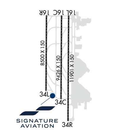
| Lat: N 4727.0 Long: W 12218.7 Elev: 432 Var: -16 Longest Runway: 11901 | ||
| Clr Del: 128.0 Dept. ATIS: 118.0 Arr. ATIS: 118.0 Ground: 121.7 Tower: 119.9E/120.95 | ||
| ||||||||||||||||||||||||||||||||||||||||||||||||||||||||||||||||||||
| ||||||||||||||||||||||||||||||||||||||||||||||||||||||||||||||||||||
| ||||||||||||||||||||||||||||||||||||||||||||||||||||||||||||||||||||
| ||||||||||||||||||||||||||||||||||||||||||||||||||||||||||||||||||||
| Rwy | Rwy | |||||||
| 9426x150 | 9426' | 111.70 - 164° | 9426x150 | 9426' | 111.70 - 344° | |||
| 11901x150 | 11901' | 110.30 - 164° | 11901x150 | 11901' | 110.30 - 344° | |||
| 8500x150 | 8500' | 110.75 - 164° | 8500x150 | 8500' | 110.75 - 344° | |||
| Runway ID | Single Wheel | Double Wheel | Double Tandem Wheel | Dual Double Wheel |
| 16C/34C | 120,000 | 250,000 | 550,000 | 1,111,000 |
| 16L/34R | 120,000 | 250,000 | 550,000 | 1,120,000 |
| 16R/34L | 120,000 | 250,000 | 482,000 | 1,007,000 |
| These numbers are Advisory and are not limits. The Airport Manager should have more accurate Weight Limits | ||||
 Airport Diagram might not be current. | |
| Facility Name: | SEATTLE-TACOMA INTL |
| City Name: | SEATTLE |
| County: | KING |
| State abbrev: | WA |
| State Name: | WASHINGTON |
| Ownership: | PUBLICLY OWNED |
| Use: | OPEN TO THE PUBLIC |
| Owner's Name: | PORT OF SEATTLE |
| Address: | BOX 1209 |
| SEATTLE, WA 98111 | |
| Owner's Phone: | 206-787-3000 |
| Manager's Name: | WENDY REITER |
| Address: | BOX 68727 |
| SEATTLE, WA 98168 | |
| Phone: | (206) 787-5229 |
| FAA Region: | NORTHWEST MOUNTAIN |
| FAA Field Office: | SEA |

| Date | Sunrise | Sunset |
|---|---|---|
| 06/08/26 Monday | 5:13 | 21:04 |
| 06/09/26 Tuesday | 5:13 | 21:05 |
| 06/10/26 Wednesday | 5:12 | 21:05 |
| 06/11/26 Thursday | 5:12 | 21:06 |
| 06/12/26 Friday | 5:12 | 21:06 |
| 06/13/26 Saturday | 5:12 | 21:07 |
| 06/14/26 Sunday | 5:12 | 21:08 |
| 06/15/26 Monday | 5:12 | 21:08 |
| 06/16/26 Tuesday | 5:12 | 21:08 |
| 06/17/26 Wednesday | 5:12 | 21:09 |
| 06/18/26 Thursday | 5:12 | 21:09 |
| 06/19/26 Friday | 5:12 | 21:09 |
| 06/20/26 Saturday | 5:12 | 21:10 |
| 06/21/26 Sunday | 5:12 | 21:10 |
| Airport Attendance Schedule | CONTINUOUS |
| Airport Status | OPERATIONAL (This Status can change at any time - please check NOTAMS) |
| Airport Lighting Schedule | SS-SR |
| Airport Storage Available | Tie Downs |
| Extra Services Available | Air Freight, Cargo Handling, Charter |
| Wind Indicator | YES - (lighted) |
| Control Tower | YES |
| CTAF Frequency | |
| Unicom Frequency | 122.950 |
| Rotating Beacon Color | WG |
| Segmented Circle | NO |
| Landing Fee | YES |
| Airport Inspected | FEDERAL - performed by FAA AIRPORTS FIELD PERSONNEL |
| Inspection Date | 01/16/2026 |
| Type of Fuel Available | JET A (freeze point -40C), JET A-1 (freeze point -50C) |
| Airframe Repair Service | NONE |
| Power Plant Repair Service | NONE |
| Latitude | N4727.0 |
| Longitude | W12218.7 (ESTIMATED) |
| Arpt Elevation | 432ft (SURVEYED) |
| Magnetic Variation | 16E |
| 10 miles S | of SEATTLE |
| Traffic Pattern Altitude | |
| Sectional Chart | SEATTLE |
| Operations (Reported) | Yearly | Avg. Daily |
|---|---|---|
| General Aviation Transient | 0 | 0 |
| General Aviation Local | 0 | 0 |
| Air Taxi | 0 | 0 |
| Commerical | 0 | 0 |
| Commuter | 0 | 0 |
| Military | 0 | 0 |
| Aircraft based on Field | |
|---|---|
| General Aviation Singles | 0 |
| General Aviation Multi | 0 |
| Jet Aircraft | 0 |
| General Aviation Helicopters | 0 |
| Military Aircraft | 0 |
| Gliders | 0 |
| Ultralights | 0 |
| FSS on field | NO |
| FSS tie-in | SEATTLE |
| FSS Phone | 1-800-WX-BRIEF |
| Who issues Notams | SEA |
| Notam D service at airport | YES |
| ARTCC Name | SEATTLE |
| Airport Certification | AIRPORT RECEIVING SCHEDULED AIR CARRIER SERVICE FROM CARRIERS CERTIFICATED BY THE CIVIL AERONAUTICS BOARD |
| Aircraft Rescue & Firefighting Index | AIRPORT HAS A CERTIFICATE UNDER CFR PART 139 |
| Airport of Entry | No |
| Custom Landing Rights | YES |
| Joint Civil/Military | No |
| Military Landing rights | YES |
| NATIONAL PLAN OF INTEGRATED AIRPORT SYSTEMS (NPIAS) |
| GRANT AGREEMENTS UNDER FAAP/ADAP/AIP |
| ASSURANCES PURSUANT TO TITLE VI, CIVIL RIGHTS ACT OF 1964 |
| AGREEMENT UNDER DLAND OR DCLA HAS EXPIRED. |
| BIRD FLOCKS ON AND INVOF ARPT - CHECK LCL ADZYS. |
| (E94) WSO/WSFO. |
| TWY A SOUTH OF TWY G RSTD TO ACFT WITH WINGSPAN 225 FT OR LESS. |
| DO NOT MISTAKE TWY T FOR LDG SFC. |
| ACES TO AIR CARGO 4 PRKG AND CARGO AREAS RSTD TO ACFT WITH WINGSPAN 170 FT OR LESS. |
| TWY FOR CORPORATE HNGR RAMP RSTD TO ACFT WITH WINGSPAN 62 FT OR LESS FOR TAXI OPS. GA CUST PRKG IS VERY LTD. |
| PPR FOR ALL GA PRKG AND SVCS;, CTC 206-433-5481. OPER HRS 0700L - 2100L, WITH A CALL OUT AVBL UPON REQ. |
| TXL W RSTRD TO ACFT WITH WINGSPAN 135 FT OR LESS NORTH OF TWY N AND 167 FT OR LESS SOUTH OF TWY N. SEATTLE RAMP TWR PRVDS ADZY CTL ONLY. |
| GA LDG FEES PAYABLE BY MAJOR CREDIT CARDS ONLY. |
| TXL ON NORTH SIDE OF TWY N STLT RSTD TO ACFT WITH WINGSPAN 118 FT OR LESS. TRI-TXL'S AT NORTH STLT: CNTR (GREEN) TXL RSTD TO ACFT WITH WINGSPAN 135 FT OR LESS. WHEN AN ACFT IS ON THE CNTR (GREEN) OR OTR (ORANGE/BLUE) TXL'S, NO OTR ACFT CAN SIMUL USE THE ADJ TXL(S). ORANGE & BLUE TXL'S ARE RSTD TO ACFT WITH WINGSPAN 118 FT OR LESS. TWO ACFT CAN SIMUL USE THE OUTER TXL'S. |
| RY STATUS LGTS ARE IN OPN. |
| ACFT WITH WINGSPAN OF 171 FT. OR MORE PRKD AT PAX GATES OR CARGO 7 MUST PROVD 30 MIN PPR PRIOR TO PUSHBACK TO SEATTLE RAMP TWR WHEN VIS LESS THAN 2400 RVR. |
| TWY J EAST OF TWY T RSTD TO ACFT WITH WINGSPAN 118 FT OR LESS. |
| RWY 16L/34R RSTD TO ACFT WITH WINGSPAN 260 FT OR LESS. |
| FLIGHT NOTIFICATION SERVICE (ADCUS) AVBL. |
| TWY H RSTRD TO ACFT WITH WINGSPAN 118 FT OR LESS. |
| TWY B SOUTH OF TWY S RSTRD TO ACFT WITH WINGSPAN 260 FT OR LESS. |
| AIR CARGO 5 RAMP DUAL ENG TAX ONLY |
| 100LL FUEL NOT AVBL. |
| THE USE OF REVERSE THRUST BYD WHAT IS NEC FOR OPNL OR SAFETY RSNS IS DISCOURAGED AT ALL TIMES. NOISE ABATEMENT FLT PROCS IN EFCT BTN 2200-0600. FOR FURTHER INFO CTC SEA NOISE ABATEMENT OFC AT 206-787-5393. |
| CONS TAXI TO TAKEOFF AT SEA. WHEN PRACTICAL, SAFE AND AVBL, CONS TAXI TO TAKEOFFS ARE ENCOURAGED. CONS TAXI TO TAKEOFFS MAY RDC ACFT NOISE WI NEARBY COMMUNITIES. |
| RPRT BIRD STRIKES TO 206-787-7233 |
| SOUTH SATELLITE TXL RSTRD TO ACFT WITH WINGSPAN OF 214 FT OR LESS. |
| CARGO1 RSTRD TO ACFT WITH WINGSPAN OF 170 FT OR LESS. |
| TO MINIMIZE NOISE, FUEL BURN AND JET BLAST, OPERATORS ARE ADVISED TO USE THE MNM RQRD THRUST WHEN TAXIING INVOF THE TRML OR ACFT PRKG AREAS. |
| HELICOPTERS LANDING & DEPARTING AVOID OVERFLYING FUEL FARM LCTD AT THE SE CORNER OF THE ARPT. |
| (E110) CONTINUOUS POWER ARPT. |
| RWY 16R/ 34LTDT 817 |
| RWY 16C/ 34CPCR VALUE: 1002/R/B/W/T |
| RWY 16L/ 34RPCR VALUE: 1147/R/B/W/T |
| RWY 16R/ 34LPCR VALUE: 866/R/B/W/T |
Airport Communications & Frequencies:
| |||||||||||||||||||||||||||||||||||||||||||||||||||||||||||||||||||||||||||||||||||||||||||||||||||||||||||||||||||||||||||||||||||||||||||||||||||||||||||||||||||||||
| Runway: 16C | Runway: 34C | ||
| Mag heading: | 164° | Mag heading: | 344° |
| Rwy Slope: | -.71% Down | Rwy Slope: | .71% Up |
| Approach: | ILS/DME | Approach: | ILS/DME |
| Pattern: | Left Traffic | Pattern: | Left Traffic |
| Markings: | PRECISION INSTRUMENT | Markings: | PRECISION INSTRUMENT |
| Marking Condition: | GOOD | Marking Condition: | GOOD |
| Arresting Dev: | Arresting Dev: | ||
| Lat & Long: | N4727.8 W12218.7 | Lat. & Long.: | N4726.3 W12218.7 |
| Elev: | 429.4 ft. MSL | Elev: | 362.9 ft. MSL |
| TCH: | 71 ft. AGL | TCH: | 73 ft. AGL |
| Visual Glide Path: | 3.00 degrees | Visual Glide Path: | 3.00 degrees |
| Displaced Threshold: | No | Displaced Threshold: | No |
| Touchdown Zone: | YES | Touchdown Zone: | YES |
| Touchdown Elev.: | 429.5 feet | Touchdown Elev.: | 387.0 feet |
| Visual Glide Slope: | 4-Light PAPI on LEFT side of Runway | Visual Glide Slope: | 4-Light PAPI on LEFT side of Runway |
| RVR Equipment: | TOUCHDOWN-MIDFIELD-ROLLOUT | RVR Equipment: | TOUCHDOWN-MIDFIELD-ROLLOUT |
| RVV Equipment: | NO | RVV Equipment: | NO |
| Approach Lights: | ALSF2 - standard 2,400 foot high intensity approach lighting system with sequenced flashers, Category II or III | Approach Lights: | MALSR - 1,400 foot medium intensity approach lighting system with runway alignment indicator lights |
| REIL: | NO | REIL: | NO |
| Centerline Lights: | YES | Centerline Lights: | YES |
| Touchdown lights: | YES | Touchdown lights: | NO |
| Runway Category: | Precision Instrument Runway | Runway Category: | Precision Instrument Runway |
| Declared Distances: | TORA:9426' TODA:9426' ASDA:9426' LDA:9426' | Declared Distances: | TORA:9426' TODA:9426' ASDA:9426' LDA:9426' |
| Runway: 16L | Runway: 34R | ||
| Mag heading: | 164° | Mag heading: | 344° |
| Rwy Slope: | -.72% Down | Rwy Slope: | .72% Up |
| Approach: | ILS/DME | Approach: | ILS/DME |
| Pattern: | Left Traffic | Pattern: | Left Traffic |
| Markings: | PRECISION INSTRUMENT | Markings: | PRECISION INSTRUMENT |
| Marking Condition: | GOOD | Marking Condition: | GOOD |
| Arresting Dev: | Arresting Dev: | ||
| Lat & Long: | N4727.8 W12218.5 | Lat. & Long.: | N4725.9 W12218.5 |
| Elev: | 432.3 ft. MSL | Elev: | 346.7 ft. MSL |
| TCH: | 76 ft. AGL | TCH: | 81 ft. AGL |
| Visual Glide Path: | 3.00 degrees | Visual Glide Path: | 2.75 degrees |
| Displaced Threshold: | No | Displaced Threshold: | No |
| Touchdown Zone: | YES | Touchdown Zone: | YES |
| Touchdown Elev.: | 432.3 feet | Touchdown Elev.: | 371.5 feet |
| Visual Glide Slope: | 4-Light PAPI on LEFT side of Runway | Visual Glide Slope: | 4-Light PAPI on LEFT side of Runway |
| RVR Equipment: | TOUCHDOWN-MIDFIELD-ROLLOUT | RVR Equipment: | TOUCHDOWN-MIDFIELD-ROLLOUT |
| RVV Equipment: | NO | RVV Equipment: | NO |
| Approach Lights: | ALSF2 - standard 2,400 foot high intensity approach lighting system with sequenced flashers, Category II or III | Approach Lights: | MALSR - 1,400 foot medium intensity approach lighting system with runway alignment indicator lights |
| REIL: | NO | REIL: | NO |
| Centerline Lights: | YES | Centerline Lights: | YES |
| Touchdown lights: | YES | Touchdown lights: | YES |
| Runway Category: | Precision Instrument Runway | Runway Category: | Precision Instrument Runway |
| Declared Distances: | TORA:11901' TODA:11901' ASDA:11901' LDA:11901' | Declared Distances: | TORA:11901' TODA:11901' ASDA:11901' LDA:11901' |
| Runway: 16R | Runway: 34L | ||
| Mag heading: | 164° | Mag heading: | 344° |
| Rwy Slope: | -.69% Down | Rwy Slope: | .69% Up |
| Approach: | ILS/DME | Approach: | ILS/DME |
| Pattern: | Left Traffic | Pattern: | Left Traffic |
| Markings: | PRECISION INSTRUMENT | Markings: | PRECISION INSTRUMENT |
| Marking Condition: | GOOD | Marking Condition: | GOOD |
| Arresting Dev: | Arresting Dev: | ||
| Lat & Long: | N4727.8 W12219.1 | Lat. & Long.: | N4726.4 W12219.1 |
| Elev: | 414.8 ft. MSL | Elev: | 356.2 ft. MSL |
| TCH: | 69 ft. AGL | TCH: | 75 ft. AGL |
| Visual Glide Path: | 3.00 degrees | Visual Glide Path: | 3.00 degrees |
| Displaced Threshold: | No | Displaced Threshold: | No |
| Touchdown Zone: | YES | Touchdown Zone: | YES |
| Touchdown Elev.: | 414.8 feet | Touchdown Elev.: | 379.3 feet |
| Visual Glide Slope: | 4-Light PAPI on RIGHT side of Runway | Visual Glide Slope: | 4-Light PAPI on LEFT side of Runway |
| RVR Equipment: | TOUCHDOWN-MIDFIELD-ROLLOUT | RVR Equipment: | TOUCHDOWN-MIDFIELD-ROLLOUT |
| RVV Equipment: | NO | RVV Equipment: | NO |
| Approach Lights: | ALSF2 - standard 2,400 foot high intensity approach lighting system with sequenced flashers, Category II or III | Approach Lights: | MALSR - 1,400 foot medium intensity approach lighting system with runway alignment indicator lights |
| REIL: | NO | REIL: | NO |
| Centerline Lights: | YES | Centerline Lights: | YES |
| Touchdown lights: | YES | Touchdown lights: | NO |
| Runway Category: | Precision Instrument Runway | Runway Category: | Precision Instrument Runway |
| Declared Distances: | TORA:8500' TODA:8500' ASDA:8500' LDA:8500' | Declared Distances: | TORA:8500' TODA:8500' ASDA:8500' LDA:8500' |
Thanks for using FltPlan.com
all rights reserved © 1999-2026 by Flight Plan LLC


