
| SIDNEY-RICHLAND MUNI SIDNEY MT |
| |
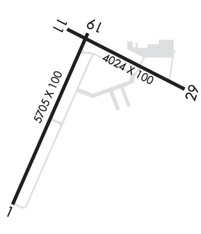
| Lat: N 4742.4 Long: W 10411.6 Elev: 1985 Var: -09 Longest Runway: 5705 | ||
| AWOS: 119.27 CTAF: 122.8 | ||
| |||||||||||||||||||||||||||||||||||||||||||||||||||||||||||||||||||||
| |||||||||||||||||||||||||||||||||||||||||||||||||||||||||||||||||||||
| |||||||||||||||||||||||||||||||||||||||||||||||||||||||||||||||||||||
| Rwy | Rwy | |||||||
| 5705x100 | 5705' | 5705x100 | 5705' | |||||
| 4024x100 | 4024' | 4024x100 | 4024' | |||||
| Runway ID | Single Wheel | Double Wheel | Double Tandem Wheel | Dual Double Wheel |
| 01/19 | 46,000 | 62,000 | 108,000 | N/A |
| 11/29 | 54,000 | 70,000 | 119,000 | N/A |
| These numbers are Advisory and are not limits. The Airport Manager should have more accurate Weight Limits | ||||
 Airport Diagram might not be current. | |
| Facility Name: | SIDNEY-RICHLAND RGNL |
| City Name: | SIDNEY |
| County: | RICHLAND |
| State abbrev: | MT |
| State Name: | MONTANA |
| Ownership: | PUBLICLY OWNED |
| Use: | OPEN TO THE PUBLIC |
| Owner's Name: | SIDNEY RICHLAND APT AUTHORITY |
| Address: | PO BOX 1050, 540 AIRPORT ROAD |
| SIDNEY, MT 59270 | |
| Owner's Phone: | 406-480-1820 |
| Manager's Name: | RYAN HUOTARI |
| Address: | 540 AIRPORT ROAD, P.O. BOX 1050 |
| SIDNEY, MT 59270 | |
| Phone: | (406) 480-1820; OR 406-480-1820 |
| FAA Region: | NORTHWEST MOUNTAIN |
| FAA Field Office: | HLN |
| Date | Sunrise | Sunset |
|---|---|---|
| 06/08/26 Monday | 4:59 | 20:53 |
| 06/09/26 Tuesday | 4:59 | 20:53 |
| 06/10/26 Wednesday | 4:59 | 20:54 |
| 06/11/26 Thursday | 4:58 | 20:55 |
| 06/12/26 Friday | 4:58 | 20:55 |
| 06/13/26 Saturday | 4:58 | 20:56 |
| 06/14/26 Sunday | 4:58 | 20:56 |
| 06/15/26 Monday | 4:58 | 20:57 |
| 06/16/26 Tuesday | 4:58 | 20:57 |
| 06/17/26 Wednesday | 4:58 | 20:57 |
| 06/18/26 Thursday | 4:58 | 20:58 |
| 06/19/26 Friday | 4:58 | 20:58 |
| 06/20/26 Saturday | 4:58 | 20:58 |
| 06/21/26 Sunday | 4:58 | 20:59 |
| Airport Attendance Schedule | 7 Days A Week 0600-1900; ON CALL 24 HOURS A DAY |
| Airport Status | OPERATIONAL (This Status can change at any time - please check NOTAMS) |
| Airport Lighting Schedule | ACTVT MIRL RYS 01/19 & 11/29; REIL RYS 01 & 19, 11 & 29; PAPI RYS 01 & 19, 11 & 29 - CTAF. |
| Airport Storage Available | Tie Downs, Hanger |
| Extra Services Available | Air Freight, Crop Dusting, Cargo Handling, Charter, Flight Instruction, Aircraft Rental, Aircraft Sales |
| Wind Indicator | YES - (lighted) |
| Control Tower | NO |
| CTAF Frequency | 122.800 |
| Unicom Frequency | 122.800 |
| Rotating Beacon Color | WG |
| Segmented Circle | YES |
| Landing Fee | NO |
| Airport Inspected | STATE - performed by FAA AIRPORTS FIELD PERSONNEL |
| Inspection Date | 07/31/2024 |
| Type of Fuel Available | Grade 100LL, JET A (freeze point -40C) |
| Airframe Repair Service | MAJOR |
| Power Plant Repair Service | MAJOR |
| Latitude | N4742.4 |
| Longitude | W10411.6 (ESTIMATED) |
| Arpt Elevation | 1985ft (SURVEYED) |
| Magnetic Variation | 09E |
| 1 miles W | of SIDNEY |
| Traffic Pattern Altitude | |
| Sectional Chart | BILLINGS |
| Operations (Reported) | Yearly | Avg. Daily |
|---|---|---|
| General Aviation Transient | 0 | 0 |
| General Aviation Local | 0 | 0 |
| Air Taxi | 0 | 0 |
| Commerical | 0 | 0 |
| Commuter | 0 | 0 |
| Military | 0 | 0 |
| Aircraft based on Field | |
|---|---|
| General Aviation Singles | 0 |
| General Aviation Multi | 0 |
| Jet Aircraft | 0 |
| General Aviation Helicopters | 0 |
| Military Aircraft | 0 |
| Gliders | 0 |
| Ultralights | 0 |
| FSS on field | NO |
| FSS tie-in | GREAT FALLS |
| FSS Phone | 1-800-WX-BRIEF |
| Who issues Notams | SDY |
| Notam D service at airport | YES |
| ARTCC Name | SALT LAKE CITY |
| Airport Certification | AIRPORT RECEIVING SCHEDULED AIR CARRIER SERVICE FROM CARRIERS CERTIFICATED BY THE CIVIL AERONAUTICS BOARD |
| Aircraft Rescue & Firefighting Index | AIRPORT HAS A CERTIFICATE UNDER CFR PART 139 |
| Airport of Entry | No |
| Custom Landing Rights | No |
| Joint Civil/Military | No |
| Military Landing rights | YES |
| NATIONAL PLAN OF INTEGRATED AIRPORT SYSTEMS (NPIAS) |
| GRANT AGREEMENTS UNDER FAAP/ADAP/AIP |
| ASSURANCES PURSUANT TO TITLE VI, CIVIL RIGHTS ACT OF 1964 |
| FOR ARPT CONDITIONS, CTC ARPT MGT - 406-480-1820. SFC CONDITIONS UNMONITORED 0400-1300Z++ |
| FLOCKS OF WATER FOWL IN VICINITY OF ARPT. |
| FOR CD IF UNA TO CTC ON FSS FREQ, CTC SALT LAKE ARTCC AT 801-320-2568. |
| RWY 01/1 9 PCR VALUE: 180/F/D/Y/T |
| RWY 11/2 9 PCR VALUE: 211/F/D/Y/T |
Airport Communications & Frequencies:
| |||||||||
| Runway: 01 | Runway: 19 | ||
| Mag heading: | 15° | Mag heading: | 195° |
| Rwy Slope: | -.03% Down | Rwy Slope: | .03% Up |
| Approach: | Approach: | ||
| Pattern: | Left Traffic | Pattern: | Right Traffic |
| Markings: | NONPRECISION INSTRUMENT | Markings: | NONPRECISION INSTRUMENT |
| Marking Condition: | GOOD | Marking Condition: | GOOD |
| Arresting Dev: | Arresting Dev: | ||
| Lat & Long: | N4741.9 W10412.1 | Lat. & Long.: | N4742.7 W10411.5 |
| Elev: | 1982.4 ft. MSL | Elev: | 1980.7 ft. MSL |
| TCH: | 33 ft. AGL | TCH: | 41 ft. AGL |
| Visual Glide Path: | 3.00 degrees | Visual Glide Path: | 3.00 degrees |
| Displaced Threshold: | No | Displaced Threshold: | No |
| Touchdown Zone: | YES | Touchdown Zone: | YES |
| Touchdown Elev.: | 1985.1 feet | Touchdown Elev.: | 1981.1 feet |
| Visual Glide Slope: | 2-Light PAPI on LEFT side of Runway | Visual Glide Slope: | 2-Light PAPI on LEFT side of Runway |
| RVR Equipment: | RVR Equipment: | ||
| RVV Equipment: | NO | RVV Equipment: | NO |
| Approach Lights: | Approach Lights: | ||
| REIL: | YES | REIL: | YES |
| Centerline Lights: | NO | Centerline Lights: | NO |
| Touchdown lights: | NO | Touchdown lights: | NO |
| Runway Category: | Runway with a Non-precision Approach having visibility minimums greater than 3/4 mile | Runway Category: | Runway with a Non-precision Approach having visibility minimums greater than 3/4 mile |
| Declared Distances: | TORA:5705' TODA:5705' ASDA:5705' LDA:5705' | Declared Distances: | TORA:5705' TODA:5705' ASDA:5705' LDA:5705' |
| Obstructions: | Obstructions: | TREE | |
| Marked: | Marked: | NOT Marked/Lighted | |
| Clearance slope: | 50:1 | Clearance slope: | 26:1 |
| Obstruction height: | Obstruction height: | 29 feet AGL | |
| Dist. from runway: | Dist. from runway: | 956 feet | |
| Centerline offset: | Centerline offset: | ||
| Comments: | Comments: |
| Runway: 11 | Runway: 29 | ||
| Mag heading: | 108° | Mag heading: | 288° |
| Rwy Slope: | -.35% Down | Rwy Slope: | .35% Up |
| Approach: | Approach: | ||
| Pattern: | Right Traffic | Pattern: | Left Traffic |
| Markings: | BASIC | Markings: | BASIC |
| Marking Condition: | GOOD | Marking Condition: | GOOD |
| Arresting Dev: | Arresting Dev: | ||
| Lat & Long: | N4742.7 W10411.7 | Lat. & Long.: | N4742.4 W10410.8 |
| Elev: | 1980.7 ft. MSL | Elev: | 1966.5 ft. MSL |
| TCH: | 40 ft. AGL | TCH: | 22 ft. AGL |
| Visual Glide Path: | 3.00 degrees | Visual Glide Path: | 3.00 degrees |
| Displaced Threshold: | No | Displaced Threshold: | No |
| Touchdown Zone: | YES | Touchdown Zone: | YES |
| Touchdown Elev.: | 1981.1 feet | Touchdown Elev.: | 1980.9 feet |
| Visual Glide Slope: | 2-Light PAPI on LEFT side of Runway | Visual Glide Slope: | 2-Light PAPI on LEFT side of Runway |
| RVR Equipment: | RVR Equipment: | ||
| RVV Equipment: | NO | RVV Equipment: | NO |
| Approach Lights: | Approach Lights: | ||
| REIL: | YES | REIL: | YES |
| Centerline Lights: | NO | Centerline Lights: | NO |
| Touchdown lights: | NO | Touchdown lights: | NO |
| Runway Category: | Runway with a Visual Approach | Runway Category: | Runway with a Visual Approach |
| Declared Distances: | TORA:4023' TODA:4023' ASDA:4023' LDA:4023' | Declared Distances: | TORA:4023' TODA:4023' ASDA:4023' LDA:4023' |
| Obstructions: | ROAD | Obstructions: | ROAD |
| Marked: | NOT Marked/Lighted | Marked: | NOT Marked/Lighted |
| Clearance slope: | 20:1 | Clearance slope: | 29:1 |
| Obstruction height: | 14 feet AGL | Obstruction height: | 10 feet AGL |
| Dist. from runway: | 489 feet | Dist. from runway: | 489 feet |
| Centerline offset: | Centerline offset: | 315 | |
| Comments: | Comments: |
Thanks for using FltPlan.com
all rights reserved © 1999-2026 by Flight Plan LLC


