| LOUISVILLE INTL-STANDIFORD FLD LOUISVILLE KY |
| |
| Lat: N 3810.4 Long: W 08544.2 Elev: 501 Var: +05 Longest Runway: 11887 | ||
| Clr Del: 126.1 Dept. ATIS: 118.72 Arr. ATIS: 118.72 Ground: 121.7 Tower: 124.2 | ||
| ||||||||||||||||||||||||||||||||||||||||||||||||||||||||||||||||||||
| ||||||||||||||||||||||||||||||||||||||||||||||||||||||||||||||||||||
| ||||||||||||||||||||||||||||||||||||||||||||||||||||||||||||||||||||
| FBOs at nearby airports who want your business: | |||||||||||||||||
| |||||||||||||||||
| |||||||||||||||||
| Rwy | Rwy | |||||||
| 7250x150 | 7250' | 7250x150 | 7250' | 109.10 - 297° | ||||
| 8579x150 | 8251' | 111.95 - 169° | 8579x150 | 8130' | 110.55 - 349° | |||
| 11887x150 | 11041' | 110.30 - 170° | 11887x150 | 10847' | 109.35 - 350° | |||
| Runway ID | Single Wheel | Double Wheel | Double Tandem Wheel | Dual Double Wheel |
| 11/29 | 75,000 | 170,000 | 360,000 | 850,000 |
| 17L/35R | 75,000 | 207,000 | 360,000 | 850,000 |
| 17R/35L | 75,000 | 207,000 | 360,000 | 850,000 |
| These numbers are Advisory and are not limits. The Airport Manager should have more accurate Weight Limits | ||||
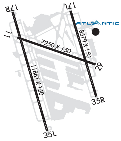 Airport Diagram might not be current. | |
| Facility Name: | LOUISVILLE MUHAMMAD ALI INTL |
| City Name: | LOUISVILLE |
| County: | JEFFERSON |
| State abbrev: | KY |
| State Name: | KENTUCKY |
| Ownership: | PUBLICLY OWNED |
| Use: | OPEN TO THE PUBLIC |
| Owner's Name: | LOUISVILLE REGIONAL ARPT AUTH |
| Address: | 700 ADMINISTRATION DRIVE |
| LOUISVILLE, KY 40209 | |
| Owner's Phone: | 502-368-6524 |
| Manager's Name: | DAN MANN |
| Address: | 700 ADMINISTRATION DRIVE |
| LOUISVILLE, KY 40209 | |
| Phone: | 502-380-8200 |
| FAA Region: | SOUTHERN |
| FAA Field Office: | MEM |

| Date | Sunrise | Sunset |
|---|---|---|
| 09/24/21 Friday | 7:32 | 19:37 |
| 09/25/21 Saturday | 7:33 | 19:36 |
| 09/26/21 Sunday | 7:34 | 19:34 |
| 09/27/21 Monday | 7:35 | 19:32 |
| 09/28/21 Tuesday | 7:36 | 19:31 |
| 09/29/21 Wednesday | 7:37 | 19:29 |
| 09/30/21 Thursday | 7:38 | 19:28 |
| 10/01/21 Friday | 7:38 | 19:26 |
| 10/02/21 Saturday | 7:39 | 19:25 |
| 10/03/21 Sunday | 7:40 | 19:23 |
| 10/04/21 Monday | 7:41 | 19:22 |
| 10/05/21 Tuesday | 7:42 | 19:20 |
| 10/06/21 Wednesday | 7:43 | 19:19 |
| 10/07/21 Thursday | 7:44 | 19:17 |
| Airport Attendance Schedule | CONTINUOUS |
| Airport Status | OPERATIONAL (This Status can change at any time - please check NOTAMS) |
| Airport Lighting Schedule | |
| Airport Storage Available | Tie Downs, Hanger |
| Extra Services Available | Air Freight, Avionics, Cargo Handling, Charter |
| Wind Indicator | YES - (lighted) |
| Control Tower | YES |
| CTAF Frequency | |
| Unicom Frequency | 122.950 |
| Rotating Beacon Color | CLEAR-GREEN (Light Land Airport) |
| Segmented Circle | NO |
| Landing Fee | NO |
| Airport Inspected | FEDERAL - performed by FAA AIRPORTS FIELD PERSONNEL |
| Inspection Date | 07/02/2021 |
| Type of Fuel Available | Grade 100LL, JET A (freeze point -40C), JET A |
| Airframe Repair Service | MAJOR |
| Power Plant Repair Service | MAJOR |
| Latitude | N3810.4 |
| Longitude | W08544.2 (ESTIMATED) |
| Arpt Elevation | 500ft (SURVEYED) |
| Magnetic Variation | 05W |
| 4 miles S | of LOUISVILLE |
| Traffic Pattern Altitude | |
| Sectional Chart | ST LOUIS |
| Operations (Reported) | Yearly | Avg. Daily |
|---|---|---|
| General Aviation Transient | 6775 | 19 |
| General Aviation Local | 534 | 1 |
| Air Taxi | 13138 | 36 |
| Commerical | 128648 | 352 |
| Commuter | 0 | 0 |
| Military | 2038 | 6 |
| Aircraft based on Field | |
|---|---|
| General Aviation Singles | 2 |
| General Aviation Multi | 3 |
| Jet Aircraft | 16 |
| General Aviation Helicopters | 0 |
| Military Aircraft | 8 |
| Gliders | 0 |
| Ultralights | 0 |
| FSS on field | NO |
| FSS tie-in | LOUISVILLE |
| FSS Phone | 1-800-WX-BRIEF |
| Who issues Notams | SDF |
| Notam D service at airport | YES |
| ARTCC Name | INDIANAPOLIS |
| Airport Certification | AIRPORT RECEIVING SCHEDULED AIR CARRIER SERVICE FROM CARRIERS CERTIFICATED BY THE CIVIL AERONAUTICS BOARD |
| Aircraft Rescue & Firefighting Index | AIRPORT HAS A CERTIFICATE UNDER CFR PART 139 |
| Airport of Entry | No |
| Custom Landing Rights | YES |
| Joint Civil/Military | No |
| Military Landing rights | YES |
| NATIONAL PLAN OF INTEGRATED AIRPORT SYSTEMS (NPIAS) |
| GRANT AGREEMENTS UNDER FAAP/ADAP/AIP |
| SURPLUS PROPERTY AGREEMENT UNDER REGULATION 16-WAA |
| ASSURANCES PURSUANT TO TITLE VI, CIVIL RIGHTS ACT OF 1964 |
| BIRDS ON AND INVOF ARPT. |
| STD DEP POINTS ON RWY 35L ARE AT TWYS A AND B. PILOTS MUST REQ USE OF RWY 35L EXTENSION. DECLARED DISTANCE FOR TKF AT TWY A AND B ASDA/TORA/TODA 10,250 FT. |
| RWY 35R AT TWY E2 INTERSECTION DEPARTURE 6300 FT AVBL. RWY 17L AT TWY E INTERSECTION DEPARTURE 7700 FT AVBL. |
| ACFT TAIL HGT 65 FT OR GREATER REQUIRE 24 HR PPR. |
| ANG-DUTY HR 1200-2000Z (1300-2100Z-DT) MON-THU, 1200-1800Z (DT 1300-1900Z) FRI. |
| ANG- FAA GP 6 ACFT RQR MIN 24 HR NOTICE FOR PPR. |
| CONTINUOUS CONSTRUCTION ON ARPT; BE ALERT FOR FREQUENT RUNWAY & TWY CLOSURES. |
| (E117) KY ANG/123TAC RECON |
| ASDE-X IN USE. OPERATE TRANSPONDERS WITH ALTITUDE REPORTING MODE AND ADS-B (IF EQUIPPED) ENABLED ON ALL AIRPORT SURFACES. |
| LINE UP AND WAIT WAIVER IN EFCT FROM SS UNTIL SR AT THE INTXN OF RWY 17R AT TWY B OR RWY 17R AT TWY A8. LINE UP AND WAIT WAIVER IN EFCT FROM SS UNTIL SR AT THE INTXN OF RWY 35L AT TWY B OR RWY 35L AT TWY A. |
| STD DEP POINTS ON RY 17R ARE AT TWY B AND RWY 17R AT TWY A8. PILOTS MUST REQ USE OF RY 17R EXTN. DECLARED DIST FOR TKF AT TWY B ASDA/TORA/TODA 10,245 FT. |
| ANG: APVL AUTH 123 AW/OGC, BASE OPS DSN 741-4581/4584, C502-413-4581/4584. CTC DERBY OPS FOR ENG START AND TAXI CLNC. |
Airport Communications & Frequencies:
| ||||||||||||||||||||||||||||||||||
| Runway: 11 | Runway: 29 | ||
| Mag heading: | 116° | Mag heading: | 296° |
| Rwy Slope: | .05% Up | Rwy Slope: | -.05% Down |
| Approach: | Approach: | LOCALIZER | |
| Pattern: | Left Traffic | Pattern: | Left Traffic |
| Markings: | BASIC | Markings: | PRECISION INSTRUMENT |
| Marking Condition: | GOOD | Marking Condition: | GOOD |
| Arresting Dev: | Arresting Dev: | ||
| Lat & Long: | N3810.8 W08544.8 | Lat. & Long.: | N3810.4 W08543.4 |
| Elev: | 476.5 ft. MSL | Elev: | 480.0 ft. MSL |
| TCH: | 65 ft. AGL | TCH: | 56 ft. AGL |
| Visual Glide Path: | 3.00 degrees | Visual Glide Path: | 3.00 degrees |
| Displaced Threshold: | No | Displaced Threshold: | No |
| Touchdown Zone: | YES | Touchdown Zone: | YES |
| Touchdown Elev.: | 478.0 feet | Touchdown Elev.: | 480.1 feet |
| Visual Glide Slope: | 4-Light PAPI on LEFT side of Runway | Visual Glide Slope: | 4-Light PAPI on LEFT side of Runway |
| RVR Equipment: | ROLLOUT | RVR Equipment: | TOUCHDOWN |
| RVV Equipment: | NO | RVV Equipment: | YES |
| Approach Lights: | Approach Lights: | MALSR - 1,400 foot medium intensity approach lighting system with runway alignment indicator lights | |
| REIL: | NO | REIL: | NO |
| Centerline Lights: | NO | Centerline Lights: | NO |
| Touchdown lights: | NO | Touchdown lights: | NO |
| Runway Category: | Runway with a Visual Approach | Runway Category: | Runway with a Non-precision Approach having visibility minimums greater than 3/4 mile |
| Declared Distances: | TORA:7250' TODA:7250' ASDA:6946' LDA:6946' | Declared Distances: | TORA:7250' TODA:7250' ASDA:7250' LDA:7250' |
| Obstructions: | BLDG | Obstructions: | |
| Marked: | NOT Marked/Lighted | Marked: | |
| Clearance slope: | 20:1 | Clearance slope: | 34:1 |
| Obstruction height: | 55 feet AGL | Obstruction height: | |
| Dist. from runway: | 1375 feet | Dist. from runway: | |
| Centerline offset: | 325 right of centerline | Centerline offset: | |
| Comments: | Comments: |
| Runway: 17L | Runway: 35R | ||
| Mag heading: | 170° | Mag heading: | 350° |
| Rwy Slope: | -.34% Down | Rwy Slope: | .34% Up |
| Approach: | ILS/DME | Approach: | ILS/DME |
| Pattern: | Left Traffic | Pattern: | Left Traffic |
| Markings: | PRECISION INSTRUMENT | Markings: | PRECISION INSTRUMENT |
| Marking Condition: | GOOD | Marking Condition: | GOOD |
| Arresting Dev: | Arresting Dev: | ||
| Lat & Long: | N3811.2 W08543.9 | Lat. & Long.: | N3809.9 W08543.4 |
| Elev: | 500.8 ft. MSL | Elev: | 471.4 ft. MSL |
| TCH: | 71 ft. AGL | TCH: | 72 ft. AGL |
| Visual Glide Path: | 3.32 degrees | Visual Glide Path: | 3.00 degrees |
| Displaced Threshold: | 328 feet | Displaced Threshold: | 449 feet |
| Touchdown Zone: | YES | Touchdown Zone: | YES |
| Touchdown Elev.: | 499.4 feet | Touchdown Elev.: | 479.5 feet |
| Visual Glide Slope: | 4-Light PAPI on LEFT side of Runway | Visual Glide Slope: | 4-Light PAPI on RIGHT side of Runway |
| RVR Equipment: | TOUCHDOWN-MIDFIELD-ROLLOUT | RVR Equipment: | TOUCHDOWN-MIDFIELD-ROLLOUT |
| RVV Equipment: | YES | RVV Equipment: | YES |
| Approach Lights: | MALSR - 1,400 foot medium intensity approach lighting system with runway alignment indicator lights | Approach Lights: | ALSF2 - standard 2,400 foot high intensity approach lighting system with sequenced flashers, Category II or III |
| REIL: | NO | REIL: | NO |
| Centerline Lights: | YES | Centerline Lights: | YES |
| Touchdown lights: | YES | Touchdown lights: | YES |
| Runway Category: | Precision Instrument Runway | Runway Category: | Precision Instrument Runway |
| Declared Distances: | TORA:8579' TODA:8579' ASDA:8129' LDA:7800' | Declared Distances: | TORA:8579' TODA:8579' ASDA:8250' LDA:7800' |
| Runway: 17R | Runway: 35L | ||
| Mag heading: | 170° | Mag heading: | 350° |
| Rwy Slope: | -.23% Down | Rwy Slope: | .23% Up |
| Approach: | ILS/DME | Approach: | ILS/DME |
| Pattern: | Left Traffic | Pattern: | Left Traffic |
| Markings: | PRECISION INSTRUMENT | Markings: | PRECISION INSTRUMENT |
| Marking Condition: | GOOD | Marking Condition: | GOOD |
| Arresting Dev: | Arresting Dev: | ||
| Lat & Long: | N3811.2 W08544.9 | Lat. & Long.: | N3809.3 W08544.3 |
| Elev: | 489.3 ft. MSL | Elev: | 461.4 ft. MSL |
| TCH: | 75 ft. AGL | TCH: | 75 ft. AGL |
| Visual Glide Path: | 3.00 degrees | Visual Glide Path: | 3.00 degrees |
| Displaced Threshold: | 846 feet | Displaced Threshold: | 1040 feet |
| Touchdown Zone: | YES | Touchdown Zone: | YES |
| Touchdown Elev.: | 485.4 feet | Touchdown Elev.: | 464.3 feet |
| Visual Glide Slope: | 4-Light PAPI on LEFT side of Runway | Visual Glide Slope: | 4-Light PAPI on LEFT side of Runway |
| RVR Equipment: | TOUCHDOWN-MIDFIELD-ROLLOUT | RVR Equipment: | TOUCHDOWN-MIDFIELD-ROLLOUT |
| RVV Equipment: | YES | RVV Equipment: | YES |
| Approach Lights: | MALSR - 1,400 foot medium intensity approach lighting system with runway alignment indicator lights | Approach Lights: | ALSF2 - standard 2,400 foot high intensity approach lighting system with sequenced flashers, Category II or III |
| REIL: | NO | REIL: | NO |
| Centerline Lights: | YES | Centerline Lights: | YES |
| Touchdown lights: | YES | Touchdown lights: | YES |
| Runway Category: | Precision Instrument Runway | Runway Category: | Precision Instrument Runway |
| Declared Distances: | TORA:11095' TODA:11095' ASDA:11095' LDA:10000' | Declared Distances: | TORA:11290' TODA:11290' ASDA:11290' LDA:10000' |
Thanks for using FltPlan.com
all rights reserved © 1999-2021 by Flight Plan LLC