| SALISBURY-OCEAN CITY WICOMICO SALISBURY MD |
| |
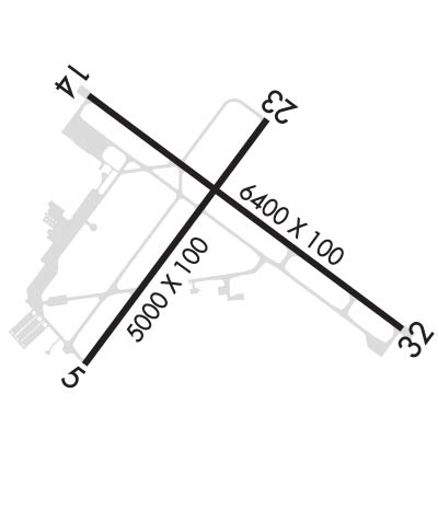
| Lat: N 3820.4 Long: W 07530.6 Elev: 53 Var: +12 Longest Runway: 6400 | ||
| Clr Del: 123.77 AWOS: 118.32 Ground: 123.77 Tower: 119.42 | ||
| ||||||||||||||||||||||||||||||||||||||||||||||||||||||||||||||||||||
| ||||||||||||||||||||||||||||||||||||||||||||||||||||||||||||||||||||
| ||||||||||||||||||||||||||||||||||||||||||||||||||||||||||||||||||||
| Rwy | Rwy | |||||||
| 5000x100 | 5000' | 5000x100 | 5000' | |||||
| 6400x100 | 6400' | 6400x100 | 6400' | 108.70 - 318° | ||||
| Runway ID | Single Wheel | Double Wheel | Double Tandem Wheel | Dual Double Wheel |
| 05/23 | 56,000 | 76,000 | 142,000 | N/A |
| 14/32 | 76,000 | 126,000 | 423,000 | 749,000 |
| These numbers are Advisory and are not limits. The Airport Manager should have more accurate Weight Limits | ||||
 Airport Diagram might not be current. | |
| Facility Name: | SALISBURY-OCEAN CITY WICOMICO RGNL |
| City Name: | SALISBURY |
| County: | WICOMICO |
| State abbrev: | MD |
| State Name: | MARYLAND |
| Ownership: | PUBLICLY OWNED |
| Use: | OPEN TO THE PUBLIC |
| Owner's Name: | WICOMICO COUNTY |
| Address: | PO BOX 870 |
| SALISBURY, MD 21803 | |
| Owner's Phone: | 410-548-4801 |
| Manager's Name: | ANTHONY RUDY |
| Address: | 5485 AIRPORT TERMINAL RD, UNIT A |
| SALISBURY, MD 21804 | |
| Phone: | 410-548-4827 |
| FAA Region: | EASTERN |
| FAA Field Office: | DCA |
| Date | Sunrise | Sunset |
|---|---|---|
| 06/08/26 Monday | 5:38 | 20:24 |
| 06/09/26 Tuesday | 5:38 | 20:25 |
| 06/10/26 Wednesday | 5:38 | 20:25 |
| 06/11/26 Thursday | 5:38 | 20:26 |
| 06/12/26 Friday | 5:38 | 20:26 |
| 06/13/26 Saturday | 5:38 | 20:26 |
| 06/14/26 Sunday | 5:38 | 20:27 |
| 06/15/26 Monday | 5:38 | 20:27 |
| 06/16/26 Tuesday | 5:38 | 20:28 |
| 06/17/26 Wednesday | 5:38 | 20:28 |
| 06/18/26 Thursday | 5:38 | 20:28 |
| 06/19/26 Friday | 5:38 | 20:29 |
| 06/20/26 Saturday | 5:38 | 20:29 |
| 06/21/26 Sunday | 5:39 | 20:29 |
| Airport Attendance Schedule | 7 Days A Week 0430-0030 |
| Airport Status | OPERATIONAL (This Status can change at any time - please check NOTAMS) |
| Airport Lighting Schedule | WHEN ATCT CLSD ACTVT MALSR RWY 32; REIL RWY 05, 14 & 23; MIRL RWY 05/23; HIRL RWY 14/32; TWY LGTS - CTAF. PAPI RWY 5, 14, 23 & 32 OPR CONSLY. |
| Airport Storage Available | Tie Downs, Hanger |
| Extra Services Available | Charter, Flight Instruction, Aircraft Rental, Aircraft Sales |
| Wind Indicator | YES - (lighted) |
| Control Tower | YES |
| CTAF Frequency | 119.425 |
| Unicom Frequency | 122.950 |
| Rotating Beacon Color | WG |
| Segmented Circle | NO |
| Landing Fee | NO |
| Airport Inspected | FEDERAL - performed by FAA AIRPORTS FIELD PERSONNEL |
| Inspection Date | 05/12/2025 |
| Type of Fuel Available | Grade 100LL, JET A (freeze point -40C) |
| Airframe Repair Service | MAJOR |
| Power Plant Repair Service | MAJOR |
| Latitude | N3820.4 |
| Longitude | W07530.6 (ESTIMATED) |
| Arpt Elevation | 52ft (SURVEYED) |
| Magnetic Variation | 12W |
| 4 miles SE | of SALISBURY |
| Traffic Pattern Altitude | |
| Sectional Chart | WASHINGTON |
| Operations (Reported) | Yearly | Avg. Daily |
|---|---|---|
| General Aviation Transient | 0 | 0 |
| General Aviation Local | 0 | 0 |
| Air Taxi | 0 | 0 |
| Commerical | 0 | 0 |
| Commuter | 0 | 0 |
| Military | 0 | 0 |
| Aircraft based on Field | |
|---|---|
| General Aviation Singles | 0 |
| General Aviation Multi | 0 |
| Jet Aircraft | 0 |
| General Aviation Helicopters | 0 |
| Military Aircraft | 0 |
| Gliders | 0 |
| Ultralights | 0 |
| FSS on field | NO |
| FSS tie-in | LEESBURG |
| FSS Phone | 1-800-WX-BRIEF |
| Who issues Notams | SBY |
| Notam D service at airport | YES |
| ARTCC Name | WASHINGTON |
| Airport Certification | AIRPORT RECEIVING SCHEDULED AIR CARRIER SERVICE FROM CARRIERS CERTIFICATED BY THE CIVIL AERONAUTICS BOARD; 24 HR PPR RQR FOR UNSKED ACR OPS CTC AMGR. |
| Aircraft Rescue & Firefighting Index | AIRPORT HAS A CERTIFICATE UNDER CFR PART 139 |
| Airport of Entry | No |
| Custom Landing Rights | No |
| Joint Civil/Military | No |
| Military Landing rights | YES |
| NATIONAL PLAN OF INTEGRATED AIRPORT SYSTEMS (NPIAS) |
| GRANT AGREEMENTS UNDER FAAP/ADAP/AIP |
| CONVEYANCE UNDER SCETION 16, FEDERAL AIRPORT ACT OF 1946 OR SECTION 23, AIRPORT AND AIRWAY DEVELOPMENT ACT OF 1970 |
| ASSURANCES PURSUANT TO TITLE VI, CIVIL RIGHTS ACT OF 1964 |
| AGREEMENT UNDER DLAND OR DCLA HAS EXPIRED. |
| MIL TRNG ACT, DEER & BIRDS ON & INVOF ARPT. |
| FOR CD CTC PATUXENT APCH AT 301-342-3740, WHEN PATUXENT APCH IS CLSD CTC POTOMAC APCH AT 866-640-4124. |
| RWY 32 NSDT REFLECTIVE LNDG ZONE MKR PANELS ADJ TO RWY. |
| TWY G SOUTH 950FT CLSD TO ACFT WINGSPAN MORE THAN 49 FT. |
| RWY 5 NONSTD REFLECTIVE LDG ZONE MKR PANELS ADJ TO THE RWY. |
| RWY 23 NONSTD REFLECTIVE LDG ZONE MKR PANELS ADJ TO THE RWY. |
| FBO HRS 0700-1900LCL. FOR SERVICES AFTER HRS CALL 410-749-0323. |
| RWY 05/2 3 PCR VALUE: 130/F/C/X/T |
| RWY 14/3 2 PCR VALUE: 400/F/D/X/T |
Airport Communications & Frequencies:
| |||||||||||||||||||||||||||||||||
| Runway: 05 | Runway: 23 | ||
| Mag heading: | 49° | Mag heading: | 229° |
| Rwy Slope: | .11% Up | Rwy Slope: | -.11% Down |
| Approach: | Approach: | ||
| Pattern: | Left Traffic | Pattern: | Left Traffic |
| Markings: | NONPRECISION INSTRUMENT | Markings: | NONPRECISION INSTRUMENT |
| Marking Condition: | GOOD | Marking Condition: | GOOD |
| Arresting Dev: | Arresting Dev: | ||
| Lat & Long: | N3820.0 W07531.0 | Lat. & Long.: | N3820.7 W07530.4 |
| Elev: | 44.1 ft. MSL | Elev: | 49.4 ft. MSL |
| TCH: | 45 ft. AGL | TCH: | 45 ft. AGL |
| Visual Glide Path: | 3.00 degrees | Visual Glide Path: | 3.00 degrees |
| Displaced Threshold: | No | Displaced Threshold: | No |
| Touchdown Zone: | YES | Touchdown Zone: | YES |
| Touchdown Elev.: | 47.4 feet | Touchdown Elev.: | 49.4 feet |
| Visual Glide Slope: | 4-Light PAPI on LEFT side of Runway | Visual Glide Slope: | 4-Light PAPI on LEFT side of Runway |
| RVR Equipment: | RVR Equipment: | ||
| RVV Equipment: | NO | RVV Equipment: | NO |
| Approach Lights: | Approach Lights: | ||
| REIL: | YES | REIL: | YES |
| Centerline Lights: | NO | Centerline Lights: | NO |
| Touchdown lights: | NO | Touchdown lights: | NO |
| Runway Category: | Runway with a Non-precision Approach having visibility minimums greater than 3/4 mile | Runway Category: | Runway with a Non-precision Approach having visibility minimums greater than 3/4 mile |
| Declared Distances: | TORA:5000' TODA:5000' ASDA:5000' LDA:5000' | Declared Distances: | TORA:5000' TODA:5000' ASDA:5000' LDA:5000' |
| Obstructions: | TREE | Obstructions: | TREE |
| Marked: | NOT Marked/Lighted | Marked: | NOT Marked/Lighted |
| Clearance slope: | 28:1 | Clearance slope: | 27:1 |
| Obstruction height: | 95 feet AGL | Obstruction height: | 95 feet AGL |
| Dist. from runway: | 2920 feet | Dist. from runway: | 2800 feet |
| Centerline offset: | 190 left of centerline | Centerline offset: | |
| Comments: | Comments: |
| Runway: 14 | Runway: 32 | ||
| Mag heading: | 139° | Mag heading: | 319° |
| Rwy Slope: | .10% Up | Rwy Slope: | -.10% Down |
| Approach: | Approach: | ILS | |
| Pattern: | Left Traffic | Pattern: | Left Traffic |
| Markings: | NONPRECISION INSTRUMENT | Markings: | PRECISION INSTRUMENT |
| Marking Condition: | GOOD | Marking Condition: | GOOD |
| Arresting Dev: | Arresting Dev: | ||
| Lat & Long: | N3820.8 W07531.0 | Lat. & Long.: | N3820.1 W07529.9 |
| Elev: | 46.2 ft. MSL | Elev: | 52.5 ft. MSL |
| TCH: | 45 ft. AGL | TCH: | 54 ft. AGL |
| Visual Glide Path: | 3.00 degrees | Visual Glide Path: | 3.00 degrees |
| Displaced Threshold: | No | Displaced Threshold: | No |
| Touchdown Zone: | YES | Touchdown Zone: | YES |
| Touchdown Elev.: | 49.1 feet | Touchdown Elev.: | 52.5 feet |
| Visual Glide Slope: | 4-Light PAPI on LEFT side of Runway | Visual Glide Slope: | 4-Light PAPI on LEFT side of Runway |
| RVR Equipment: | RVR Equipment: | ||
| RVV Equipment: | NO | RVV Equipment: | NO |
| Approach Lights: | Approach Lights: | MALSR - 1,400 foot medium intensity approach lighting system with runway alignment indicator lights | |
| REIL: | YES | REIL: | NO |
| Centerline Lights: | NO | Centerline Lights: | NO |
| Touchdown lights: | NO | Touchdown lights: | NO |
| Runway Category: | Runway with a Non-precision Approach having visibility minimums greater than 3/4 mile | Runway Category: | Precision Instrument Runway |
| Declared Distances: | TORA:6400' TODA:6400' ASDA:6400' LDA:6400' | Declared Distances: | TORA:6400' TODA:6400' ASDA:6400' LDA:6400' |
Thanks for using FltPlan.com
all rights reserved © 1999-2026 by Flight Plan LLC