| SHELBY SHELBY MT |
| |
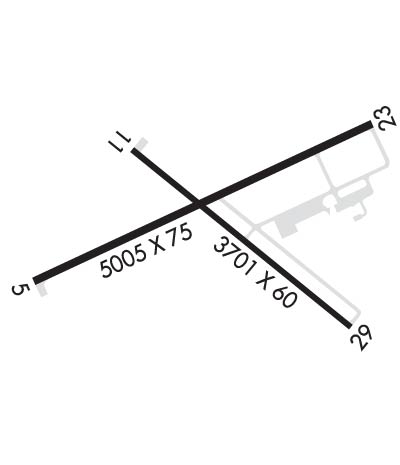
| Lat: N 4832.4 Long: W 11152.3 Elev: 3443 Var: -15 Longest Runway: 5005 | ||
| CTAF: 122.8 | ||
| |||||||||||||||||||||||
| |||||||||||||||||||||||
| Rwy | Rwy | |||||||
| 5005x75 | 5005' | 5005x75 | 5005' | |||||
| 3701x60 | 3701' | 3701x60 | 3701' | |||||
| Runway ID | Single Wheel | Double Wheel | Double Tandem Wheel | Dual Double Wheel |
| 05/23 | 15,000 | N/A | N/A | N/A |
| 11/29 | 15,000 | N/A | N/A | N/A |
| These numbers are Advisory and are not limits. The Airport Manager should have more accurate Weight Limits | ||||
 Airport Diagram might not be current. | |
| Facility Name: | SHELBY |
| City Name: | SHELBY |
| County: | TOOLE |
| State abbrev: | MT |
| State Name: | MONTANA |
| Ownership: | PUBLICLY OWNED |
| Use: | OPEN TO THE PUBLIC |
| Owner's Name: | TOOLE COUNTY |
| Address: | 226 1ST ST. SOUTH |
| SHELBY, MT 59474-1920 | |
| Owner's Phone: | 406-424-8310 |
| Manager's Name: | JERRY LARSON JR |
| Address: | PO BOX 210 |
| SHELBY, MT 59474 | |
| Phone: | (406) 450-2463 |
| FAA Region: | NORTHWEST MOUNTAIN |
| FAA Field Office: | HLN |
| Date | Sunrise | Sunset |
|---|---|---|
| 09/24/21 Friday | 7:17 | 19:21 |
| 09/25/21 Saturday | 7:18 | 19:19 |
| 09/26/21 Sunday | 7:19 | 19:17 |
| 09/27/21 Monday | 7:21 | 19:15 |
| 09/28/21 Tuesday | 7:22 | 19:13 |
| 09/29/21 Wednesday | 7:24 | 19:11 |
| 09/30/21 Thursday | 7:25 | 19:09 |
| 10/01/21 Friday | 7:27 | 19:07 |
| 10/02/21 Saturday | 7:28 | 19:05 |
| 10/03/21 Sunday | 7:30 | 19:03 |
| 10/04/21 Monday | 7:31 | 19:01 |
| 10/05/21 Tuesday | 7:32 | 18:58 |
| 10/06/21 Wednesday | 7:34 | 18:56 |
| 10/07/21 Thursday | 7:35 | 18:54 |
| Airport Attendance Schedule | MON-FRI 0800-1800 |
| Airport Status | OPERATIONAL (This Status can change at any time - please check NOTAMS) |
| Airport Lighting Schedule | ACTVT PAPI RWY 05 & 23; MIRL RWY 05/23 & 11/29-CTAF. |
| Airport Storage Available | Tie Downs |
| Extra Services Available | Crop Dusting, Flight Instruction, Aircraft Rental |
| Wind Indicator | YES - (lighted) |
| Control Tower | NO |
| CTAF Frequency | 122.800 |
| Unicom Frequency | 122.800 |
| Rotating Beacon Color | CLEAR-GREEN (Light Land Airport) |
| Segmented Circle | YES |
| Landing Fee | NO |
| Airport Inspected | STATE - performed by STATE AERONAUTICAL PERSONNEL |
| Inspection Date | 08/14/2020 |
| Type of Fuel Available | Grade 100LL, JET A; -10FOR FUEL AFTER HRS CALL 406-450-2461 OR 406-450-2463. SELF SVC CREDIT CARD FOR 100LL & JET A+. FUEL TRUCK AVBL FOR JET A+. |
| Airframe Repair Service | NONE |
| Power Plant Repair Service | NONE |
| Latitude | N4832.4 |
| Longitude | W11152.3 (ESTIMATED) |
| Arpt Elevation | 3442ft (SURVEYED) |
| Magnetic Variation | 15E |
| 2 miles N | of SHELBY |
| Traffic Pattern Altitude | |
| Sectional Chart | GREAT FALLS |
| Operations (Reported) | Yearly | Avg. Daily |
|---|---|---|
| General Aviation Transient | 1000 | 3 |
| General Aviation Local | 7050 | 19 |
| Air Taxi | 100 | 0 |
| Commerical | 0 | 0 |
| Commuter | 0 | 0 |
| Military | 250 | 1 |
| Aircraft based on Field | |
|---|---|
| General Aviation Singles | 15 |
| General Aviation Multi | 3 |
| Jet Aircraft | 2 |
| General Aviation Helicopters | 1 |
| Military Aircraft | 0 |
| Gliders | 0 |
| Ultralights | 0 |
| FSS on field | NO |
| FSS tie-in | GREAT FALLS |
| FSS Phone | 1-800-WX-BRIEF |
| Who issues Notams | GTF |
| Notam D service at airport | YES |
| ARTCC Name | SALT LAKE CITY |
| Airport Certification | |
| Aircraft Rescue & Firefighting Index | None |
| Airport of Entry | No |
| Custom Landing Rights | No |
| Joint Civil/Military | No |
| Military Landing rights | YES |
| NATIONAL PLAN OF INTEGRATED AIRPORT SYSTEMS (NPIAS) |
| GRANT AGREEMENTS UNDER FAAP/ADAP/AIP |
| ASSURANCES PURSUANT TO TITLE VI, CIVIL RIGHTS ACT OF 1964 |
| DEER ON & INVOF ARPT. |
| TWY EDGES MKD WITH REFLECTORS. |
| FOR CD CTC SALT LAKE ARTCC AT 801-320-2568. |
Airport Communications & Frequencies:
| |||||||||
| Runway: 05 | Runway: 23 | ||
| Mag heading: | 50° | Mag heading: | 230° |
| Rwy Slope: | .49% Up | Rwy Slope: | -.49% Down |
| Approach: | Approach: | ||
| Pattern: | Left Traffic | Pattern: | Left Traffic |
| Markings: | NONPRECISION INSTRUMENT | Markings: | NONPRECISION INSTRUMENT |
| Marking Condition: | GOOD | Marking Condition: | GOOD |
| Arresting Dev: | Arresting Dev: | ||
| Lat & Long: | N4832.3 W11152.9 | Lat. & Long.: | N4832.6 W11151.8 |
| Elev: | 3418.1 ft. MSL | Elev: | 3442.8 ft. MSL |
| TCH: | 29 ft. AGL | TCH: | 32 ft. AGL |
| Visual Glide Path: | 3.00 degrees | Visual Glide Path: | 3.00 degrees |
| Displaced Threshold: | No | Displaced Threshold: | No |
| Touchdown Zone: | YES | Touchdown Zone: | YES |
| Touchdown Elev.: | 3426.7 feet | Touchdown Elev.: | 3442.9 feet |
| Visual Glide Slope: | 2-Light PAPI on LEFT side of Runway | Visual Glide Slope: | 2-Light PAPI on LEFT side of Runway |
| RVR Equipment: | RVR Equipment: | ||
| RVV Equipment: | NO | RVV Equipment: | NO |
| Approach Lights: | Approach Lights: | ||
| REIL: | NO | REIL: | NO |
| Centerline Lights: | NO | Centerline Lights: | NO |
| Touchdown lights: | NO | Touchdown lights: | NO |
| Runway Category: | Runway with a Non-precision Approach | Runway Category: | Runway with a Non-precision Approach |
| Declared Distances: | Declared Distances: |
| Runway: 11 | Runway: 29 | ||
| Mag heading: | 114° | Mag heading: | 294° |
| Rwy Slope: | .25% Up | Rwy Slope: | -.25% Down |
| Approach: | Approach: | ||
| Pattern: | Left Traffic | Pattern: | Left Traffic |
| Markings: | BASIC | Markings: | BASIC |
| Marking Condition: | GOOD | Marking Condition: | GOOD |
| Arresting Dev: | Arresting Dev: | ||
| Lat & Long: | N4832.6 W11152.6 | Lat. & Long.: | N4832.2 W11151.9 |
| Elev: | 3419.6 ft. MSL | Elev: | 3428.7 ft. MSL |
| TCH: | 31 ft. AGL | TCH: | 38 ft. AGL |
| Visual Glide Path: | 3.00 degrees | Visual Glide Path: | 3.00 degrees |
| Displaced Threshold: | No | Displaced Threshold: | No |
| Touchdown Zone: | YES | Touchdown Zone: | YES |
| Touchdown Elev.: | 3428.7 feet | Touchdown Elev.: | 3428.7 feet |
| Visual Glide Slope: | 2-Light PAPI on LEFT side of Runway | Visual Glide Slope: | 2-Light PAPI on LEFT side of Runway |
| RVR Equipment: | RVR Equipment: | ||
| RVV Equipment: | NO | RVV Equipment: | NO |
| Approach Lights: | Approach Lights: | ||
| REIL: | NO | REIL: | NO |
| Centerline Lights: | NO | Centerline Lights: | NO |
| Touchdown lights: | NO | Touchdown lights: | NO |
| Runway Category: | Runway with a Visual Approach | Runway Category: | Runway with a Visual Approach |
| Declared Distances: | Declared Distances: |
Thanks for using FltPlan.com
all rights reserved © 1999-2021 by Flight Plan LLC