
| SAN LUIS COUNTY RGNL SAN LUIS OBISPO CA |
| |
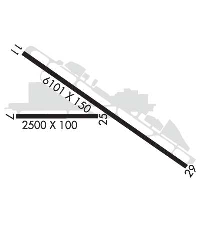
| Lat: N 3514.2 Long: W 12038.6 Elev: 212 Var: -15 Longest Runway: 6101 | ||
| Dept. ATIS: 120.6 Arr. ATIS: 120.6 Ground: 121.6 Tower: 124.0 | ||
| ||||||||||||||||||||||||||||||||||||||||||||
| ||||||||||||||||||||||||||||||||||||||||||||
| ||||||||||||||||||||||||||||||||||||||||||||
| ||||||||||||||||||||||||||||||||||||||||||||
| Rwy | Rwy | |||||||
| 2500x100 | 2500' | 2500x100 | 2500' | |||||
| 6101x150 | 5301' | 109.70 - 109° | 6101x150 | 5600' | ||||
| Runway ID | Single Wheel | Double Wheel | Double Tandem Wheel | Dual Double Wheel |
| 07/25 | 24,000 | 38,000 | N/A | N/A |
| 11/29 | 96,000 | 124,000 | 181,000 | N/A |
| These numbers are Advisory and are not limits. The Airport Manager should have more accurate Weight Limits | ||||
 Airport Diagram might not be current. | |
| Facility Name: | SAN LUIS OBISPO COUNTY RGNL |
| City Name: | SAN LUIS OBISPO |
| County: | SAN LUIS OBISPO |
| State abbrev: | CA |
| State Name: | CALIFORNIA |
| Ownership: | PUBLICLY OWNED |
| Use: | OPEN TO THE PUBLIC |
| Owner's Name: | SAN LUIS OBISPO COUNTY |
| Address: | COUNTY GOVERNMENT CENTER |
| SAN LUIS OBISPO, CA 93408 | |
| Owner's Phone: | (805) 781-5205 |
| Manager's Name: | COURTNEY JOHNSON; DEPUTY DIR: TIM O'KEEFFE 805-788-2000. |
| Address: | 975 AIRPORT DRIVE, SUITE 1 |
| SAN LUIS OBISPO, CA 93401 | |
| Phone: | 805-781-5218 |
| FAA Region: | WESTERN-PACIFIC |
| FAA Field Office: | SFO |
| Date | Sunrise | Sunset |
|---|---|---|
| 06/08/26 Monday | 5:48 | 20:16 |
| 06/09/26 Tuesday | 5:48 | 20:16 |
| 06/10/26 Wednesday | 5:47 | 20:17 |
| 06/11/26 Thursday | 5:47 | 20:17 |
| 06/12/26 Friday | 5:47 | 20:18 |
| 06/13/26 Saturday | 5:47 | 20:18 |
| 06/14/26 Sunday | 5:47 | 20:18 |
| 06/15/26 Monday | 5:47 | 20:19 |
| 06/16/26 Tuesday | 5:47 | 20:19 |
| 06/17/26 Wednesday | 5:48 | 20:19 |
| 06/18/26 Thursday | 5:48 | 20:20 |
| 06/19/26 Friday | 5:48 | 20:20 |
| 06/20/26 Saturday | 5:48 | 20:20 |
| 06/21/26 Sunday | 5:48 | 20:20 |
| Airport Attendance Schedule | 7 Days A Week 0600-1700 |
| Airport Status | OPERATIONAL (This Status can change at any time - please check NOTAMS) |
| Airport Lighting Schedule | ACTVT MALSR RWY 11; REIL RWY 29; VASI RWY 11; HIRL RWY 11/29 - CTAF. VASI RWY 29 OPR CONSLY. |
| Airport Storage Available | Tie Downs |
| Extra Services Available | Air Freight, Avionics, Cargo Handling, Charter, Flight Instruction, Aircraft Rental, Aircraft Sales, Annual Surveying |
| Wind Indicator | YES - (lighted) |
| Control Tower | YES |
| CTAF Frequency | 124.000 |
| Unicom Frequency | 122.950 |
| Rotating Beacon Color | WG |
| Segmented Circle | YES |
| Landing Fee | NO |
| Airport Inspected | FEDERAL - performed by FAA AIRPORTS FIELD PERSONNEL |
| Inspection Date | 03/26/2025 |
| Type of Fuel Available | Grade 100LL, JET A (freeze point -40C) |
| Airframe Repair Service | MAJOR |
| Power Plant Repair Service | MAJOR |
| Latitude | N3514.2 |
| Longitude | W12038.6 (ESTIMATED) |
| Arpt Elevation | 212ft (SURVEYED) |
| Magnetic Variation | 15E |
| 3 miles S | of SAN LUIS OBISPO |
| Traffic Pattern Altitude | TPA 991 AGL SINGLE ENG; 1491 AGL MULTI-ENG, JET & HIGH PER. |
| Sectional Chart | LOS ANGELES |
| Operations (Reported) | Yearly | Avg. Daily |
|---|---|---|
| General Aviation Transient | 0 | 0 |
| General Aviation Local | 0 | 0 |
| Air Taxi | 0 | 0 |
| Commerical | 0 | 0 |
| Commuter | 0 | 0 |
| Military | 0 | 0 |
| Aircraft based on Field | |
|---|---|
| General Aviation Singles | 0 |
| General Aviation Multi | 0 |
| Jet Aircraft | 0 |
| General Aviation Helicopters | 0 |
| Military Aircraft | 0 |
| Gliders | 0 |
| Ultralights | 0 |
| FSS on field | NO |
| FSS tie-in | HAWTHORNE |
| FSS Phone | 1-800-WX-BRIEF |
| Who issues Notams | SBP |
| Notam D service at airport | YES |
| ARTCC Name | LOS ANGELES |
| Airport Certification | AIRPORT RECEIVING SCHEDULED AIR CARRIER SERVICE FROM CARRIERS CERTIFICATED BY THE CIVIL AERONAUTICS BOARD |
| Aircraft Rescue & Firefighting Index | AIRPORT HAS A CERTIFICATE UNDER CFR PART 139 |
| Airport of Entry | No |
| Custom Landing Rights | No |
| Joint Civil/Military | No |
| Military Landing rights | YES |
| NATIONAL PLAN OF INTEGRATED AIRPORT SYSTEMS (NPIAS) |
| GRANT AGREEMENTS UNDER FAAP/ADAP/AIP |
| ASSURANCES PURSUANT TO TITLE VI, CIVIL RIGHTS ACT OF 1964 |
| RECURRING FLOCKS OF WATERFOWL ON AND IN VICINITY OF ARPT DURG WINTER MONTHS. |
| TWY A BTN TWYS C AND F WILL BE PDCLY RSTRD FOR ACFT WITH WINGSPAN OF 79 FT OR GTR DRG OPNS ON RWY 11/29. |
| TAXILANE WIDTHS LESS THAN STANDARD. |
| NOISE SENSITIVE ARPT; TCH 50 FT; FOR NOISE ABATEMENT INFO CTC AMGR (805) 781-5205. |
| RY 29 DESIGNATED CALM WIND RY. |
| ATCT UNABLE TO SEE ACFT IN HOLDING BAY AT NW END OF TWY A. MOVEMENT FM HOLDING BAY REQUIRES ATCT APVL DURG ATCT HRS. |
| TRANSIENT PARKING EXCEEDING 2 HRS CTC FBO EXCEPT FOR AIR CARRIERS. |
| PUSHBACK FM TRML GATES AT PILOT'S DISCRETION. DO NOT CALL GND CTL FOR PUSHBACK. |
| TWY A RUN-UP AREA FOR RWY 29, JETS USE MNM BREAKAWAY PWR. |
| RWY 07/2 5 RWY 07/25 NOT AVBL FOR PART 121/PART 380 OPS WITH SKED PAX CARRYING OPS MORE THAN 9 PAX SEATS AND NON-SKED PAX CARRYING OPS MORE THAN 30 PAX SEATS. |
| RWY 11/2 9 BLAST PAD DEP END RY 11: 600 FT X 200 FT. BLAST PAD DEP END RY 29: 600 FT X 200 FT. |
| RWY 07/2 5 PCR VALUE: 90/F/D/X/T |
| RWY 11/2 9 PCR VALUE: 390/F/D/X/T |
Airport Communications & Frequencies:
| |||||||||||||||||||||||||
| Runway: 07 | Runway: 25 | ||
| Mag heading: | 75° | Mag heading: | 255° |
| Rwy Slope: | 1.08% Up | Rwy Slope: | -1.08% Down |
| Approach: | Approach: | ||
| Pattern: | Left Traffic | Pattern: | Left Traffic |
| Markings: | BASIC | Markings: | BASIC |
| Marking Condition: | GOOD | Marking Condition: | GOOD |
| Arresting Dev: | Arresting Dev: | ||
| Lat & Long: | N3514.2 W12039.0 | Lat. & Long.: | N3514.2 W12038.5 |
| Elev: | 162.0 ft. MSL | Elev: | 189.0 ft. MSL |
| TCH: | TCH: | ||
| Visual Glide Path: | Visual Glide Path: | ||
| Displaced Threshold: | No | Displaced Threshold: | No |
| Touchdown Zone: | YES | Touchdown Zone: | YES |
| Touchdown Elev.: | 189.0 feet | Touchdown Elev.: | 189.0 feet |
| Visual Glide Slope: | Visual Glide Slope: | ||
| RVR Equipment: | RVR Equipment: | ||
| RVV Equipment: | NO | RVV Equipment: | NO |
| Approach Lights: | Approach Lights: | ||
| REIL: | NO | REIL: | NO |
| Centerline Lights: | NO | Centerline Lights: | NO |
| Touchdown lights: | NO | Touchdown lights: | NO |
| Runway Category: | Runway with a Visual Approach | Runway Category: | Runway with a Visual Approach |
| Declared Distances: | TORA:2500' TODA:2500' ASDA:2500' LDA:2500' | Declared Distances: | TORA:2500' TODA:2500' ASDA:2500' LDA:2500' |
| Obstructions: | ROAD | Obstructions: | |
| Marked: | NOT Marked/Lighted | Marked: | |
| Clearance slope: | 21:1 | Clearance slope: | 50:1 |
| Obstruction height: | 10 feet AGL | Obstruction height: | |
| Dist. from runway: | 410 feet | Dist. from runway: | |
| Centerline offset: | Centerline offset: | ||
| Comments: | Comments: |
| Runway: 11 | Runway: 29 | ||
| Mag heading: | 110° | Mag heading: | 290° |
| Rwy Slope: | .83% Up | Rwy Slope: | -.83% Down |
| Approach: | ILS | Approach: | |
| Pattern: | Left Traffic | Pattern: | Left Traffic |
| Markings: | PRECISION INSTRUMENT | Markings: | NONPRECISION INSTRUMENT |
| Marking Condition: | GOOD | Marking Condition: | GOOD |
| Arresting Dev: | EMAS; ENGINEERED MATERIAL ARRESTING SYSTEM (EMAS) 300 FT IN LENGTH BY 170 FT IN WIDTH LCTD AT THE DER 11. | Arresting Dev: | EMAS; ENGINEERED MATERIAL ARRESTING SYSTEM (EMAS) 312 FT IN LENGTH BY 170 FT IN WIDTH LCTD AT THE DER 29. |
| Lat & Long: | N3514.5 W12039.0 | Lat. & Long.: | N3514.0 W12038.0 |
| Elev: | 161.8 ft. MSL | Elev: | 212.2 ft. MSL |
| TCH: | 50 ft. AGL | TCH: | 50 ft. AGL |
| Visual Glide Path: | 3.00 degrees | Visual Glide Path: | 3.25 degrees |
| Displaced Threshold: | 800 feet | Displaced Threshold: | 501 feet |
| Touchdown Zone: | YES | Touchdown Zone: | YES |
| Touchdown Elev.: | 197.8 feet | Touchdown Elev.: | 211.8 feet |
| Visual Glide Slope: | 4-BOX VASI ON LEFT SIDE OF RUNWAY; RWY 11 VASI UNUSBL BYD 5 DEGS RIGHT OF RWY CNTRLN. | Visual Glide Slope: | 4-BOX VASI ON LEFT SIDE OF RUNWAY |
| RVR Equipment: | RVR Equipment: | ||
| RVV Equipment: | NO | RVV Equipment: | NO |
| Approach Lights: | MALSR - 1,400 foot medium intensity approach lighting system with runway alignment indicator lights | Approach Lights: | |
| REIL: | NO | REIL: | YES |
| Centerline Lights: | NO | Centerline Lights: | NO |
| Touchdown lights: | NO | Touchdown lights: | NO |
| Runway Category: | Precision Instrument Runway | Runway Category: | Runway with a Non-precision Approach having visibility minimums greater than 3/4 mile |
| Declared Distances: | TORA:6100' TODA:6100' ASDA:6100' LDA:5300' | Declared Distances: | TORA:6100' TODA:6100' ASDA:6100' LDA:5600' |
Thanks for using FltPlan.com
all rights reserved © 1999-2026 by Flight Plan LLC
