
| EMANUEL COUNTY SWAINSBORO GA |
| |
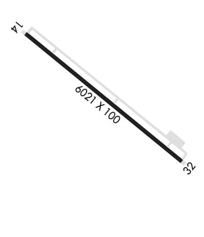
| Lat: N 3236.5 Long: W 08222.2 Elev: 327 Var: +06 Longest Runway: 6021 | ||
| AWOS: 133.37 CTAF: 122.97 | ||
| ||||||
| ||||||
|
| Rwy | Rwy | |||||||
| 6021x100 | 6021' | 109.35 - 135° | 6021x100 | 6021' | ||||
| Runway ID | Single Wheel | Double Wheel | Double Tandem Wheel | Dual Double Wheel |
| 14/32 | 45,000 | 65,000 | 120,000 | N/A |
| These numbers are Advisory and are not limits. The Airport Manager should have more accurate Weight Limits | ||||
 Airport Diagram might not be current. | |
| Facility Name: | EAST GEORGIA RGNL |
| City Name: | SWAINSBORO |
| County: | EMANUEL |
| State abbrev: | GA |
| State Name: | GEORGIA |
| Ownership: | PUBLICLY OWNED |
| Use: | OPEN TO THE PUBLIC |
| Owner's Name: | CITY OF SWAINSBORO |
| Address: | 101 WEST MAIN STREET |
| SWAINSBORO, GA 30401 | |
| Owner's Phone: | 478-237-7025 |
| Manager's Name: | KEN WARNOCK |
| Address: | 102 SOUTH MAIN STREET |
| SWAINSBORO, GA 30401 | |
| Phone: | 478-237-5882 |
| FAA Region: | SOUTHERN |
| FAA Field Office: | ATL |
| Date | Sunrise | Sunset |
|---|---|---|
| 06/08/26 Monday | 6:21 | 20:36 |
| 06/09/26 Tuesday | 6:21 | 20:36 |
| 06/10/26 Wednesday | 6:21 | 20:37 |
| 06/11/26 Thursday | 6:21 | 20:37 |
| 06/12/26 Friday | 6:21 | 20:37 |
| 06/13/26 Saturday | 6:21 | 20:38 |
| 06/14/26 Sunday | 6:21 | 20:38 |
| 06/15/26 Monday | 6:21 | 20:39 |
| 06/16/26 Tuesday | 6:21 | 20:39 |
| 06/17/26 Wednesday | 6:22 | 20:39 |
| 06/18/26 Thursday | 6:22 | 20:39 |
| 06/19/26 Friday | 6:22 | 20:40 |
| 06/20/26 Saturday | 6:22 | 20:40 |
| 06/21/26 Sunday | 6:22 | 20:40 |
| Airport Attendance Schedule | MON-SAT 0800-1700; AFT HRS & SUNDAY PHONE 803-530-3124. |
| Airport Status | OPERATIONAL (This Status can change at any time - please check NOTAMS) |
| Airport Lighting Schedule | ACTVT PAPI RWY 14; HIRL RWY 14/32 - CTAF. |
| Airport Storage Available | Tie Downs, Hanger |
| Extra Services Available | Air Freight, Charter, Flight Instruction, Annual Surveying |
| Wind Indicator | YES - (lighted) |
| Control Tower | NO |
| CTAF Frequency | 122.975 |
| Unicom Frequency | 122.975 |
| Rotating Beacon Color | WG |
| Segmented Circle | YES |
| Landing Fee | NO; ONLY CHARGE FOR PART 135 OPS. |
| Airport Inspected | STATE - performed by STATE AERONAUTICAL PERSONNEL |
| Inspection Date | 04/03/2025 |
| Type of Fuel Available | Grade 100LL, JET A (freeze point -40C), JET A; -10FUEL IS SELF SERVICE AFTER HRS. |
| Airframe Repair Service | MAJOR |
| Power Plant Repair Service | MAJOR |
| Latitude | N3236.5 |
| Longitude | W08222.2 (ESTIMATED) |
| Arpt Elevation | 327ft (SURVEYED) |
| Magnetic Variation | 06W |
| 2 miles NW | of SWAINSBORO |
| Traffic Pattern Altitude | |
| Sectional Chart | ATLANTA |
| Operations (Reported) | Yearly | Avg. Daily |
|---|---|---|
| General Aviation Transient | 0 | 0 |
| General Aviation Local | 0 | 0 |
| Air Taxi | 0 | 0 |
| Commerical | 0 | 0 |
| Commuter | 0 | 0 |
| Military | 0 | 0 |
| Aircraft based on Field | |
|---|---|
| General Aviation Singles | 0 |
| General Aviation Multi | 0 |
| Jet Aircraft | 0 |
| General Aviation Helicopters | 0 |
| Military Aircraft | 0 |
| Gliders | 0 |
| Ultralights | 0 |
| FSS on field | NO |
| FSS tie-in | MACON |
| FSS Phone | 1-800-WX-BRIEF |
| Who issues Notams | MCN |
| Notam D service at airport | YES |
| ARTCC Name | ATLANTA |
| Airport Certification | |
| Aircraft Rescue & Firefighting Index | None |
| Airport of Entry | No |
| Custom Landing Rights | No |
| Joint Civil/Military | No |
| Military Landing rights | YES |
| NATIONAL PLAN OF INTEGRATED AIRPORT SYSTEMS (NPIAS) |
| GRANT AGREEMENTS UNDER FAAP/ADAP/AIP |
| ASSURANCES PURSUANT TO TITLE VI, CIVIL RIGHTS ACT OF 1964 |
| DEER ON & INVOF ARPT. |
| GEESE ON AND INVOF ARPT. |
| FOR CD CTC ATLANTA ARTCC AT 770-210-7692. |
Airport Communications & Frequencies:
| |||||||||
| Runway: 14 | Runway: 32 | ||
| Mag heading: | 135° | Mag heading: | 315° |
| Rwy Slope: | -.03% Down | Rwy Slope: | .03% Up |
| Approach: | ILS/DME | Approach: | |
| Pattern: | Left Traffic | Pattern: | Left Traffic |
| Markings: | PRECISION INSTRUMENT | Markings: | NONPRECISION INSTRUMENT |
| Marking Condition: | FAIR | Marking Condition: | FAIR |
| Arresting Dev: | Arresting Dev: | ||
| Lat & Long: | N3236.9 W08222.6 | Lat. & Long.: | N3236.2 W08221.7 |
| Elev: | 324.0 ft. MSL | Elev: | 322.0 ft. MSL |
| TCH: | 45 ft. AGL | TCH: | |
| Visual Glide Path: | 3.00 degrees | Visual Glide Path: | |
| Displaced Threshold: | No | Displaced Threshold: | No |
| Touchdown Zone: | YES | Touchdown Zone: | YES |
| Touchdown Elev.: | 327.2 feet | Touchdown Elev.: | 323.3 feet |
| Visual Glide Slope: | 4-Light PAPI on LEFT side of Runway | Visual Glide Slope: | |
| RVR Equipment: | RVR Equipment: | ||
| RVV Equipment: | NO | RVV Equipment: | NO |
| Approach Lights: | Approach Lights: | ||
| REIL: | NO | REIL: | NO |
| Centerline Lights: | NO | Centerline Lights: | NO |
| Touchdown lights: | NO | Touchdown lights: | NO |
| Runway Category: | Precision Instrument Runway | Runway Category: | Runway with a Non-precision Approach having visibility minimums greater than 3/4 mile |
| Declared Distances: | Declared Distances: | ||
| Obstructions: | TREES | Obstructions: | BLDG |
| Marked: | NOT Marked/Lighted | Marked: | LIGHTED |
| Clearance slope: | 28:1 | Clearance slope: | 5:1 |
| Obstruction height: | 43 feet AGL | Obstruction height: | 5 feet AGL |
| Dist. from runway: | 1445 feet | Dist. from runway: | 226 feet |
| Centerline offset: | 648 left of centerline | Centerline offset: | 468 feet right of centerline |
| Comments: | Comments: | 6 FT FENCE AND VEHICLES LOCATED 400 FT RIGHT 0-200 FT FROM THR. |
Thanks for using FltPlan.com
all rights reserved © 1999-2026 by Flight Plan LLC
