
| SANTA BARBARA MUNI SANTA BARBARA CA |
| |
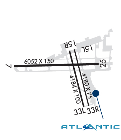
| Lat: N 3425.6 Long: W 11950.5 Elev: 14 Var: -14 Longest Runway: 6052 | ||
| Clr Del: 132.9 Dept. ATIS: 132.65 Arr. ATIS: 132.65 Ground: 121.7 Tower: 119.7 | ||
| ||||||||||||||||||||||||||||||||||||||||||||||||||||||||||||||||||||
| ||||||||||||||||||||||||||||||||||||||||||||||||||||||||||||||||||||
| ||||||||||||||||||||||||||||||||||||||||||||||||||||||||||||||||||||
| ||||||||||||||||||||||||||||||||||||||||||||||||||||||||||||||||||||
| ||||||||||||||||||||||||||||||||||||||||||||||||||||||||||||||||||||
| ||||||||||||||||||||||||||||||||||||||||||||||||||||||||||||||||||||
| Rwy | Rwy | |||||||
| 6052x150 | 6052' | 110.30 - 074° | 6052x150 | 6052' | ||||
| 4180x75 | 4180' | 4180x75 | 4180' | |||||
| 4184x100 | 4184' | 4184x100 | 4184' | |||||
| Runway ID | Single Wheel | Double Wheel | Double Tandem Wheel | Dual Double Wheel |
| 07/25 | 113,000 | 188,000 | 318,000 | N/A |
| 15L/33R | 39,000 | 61,000 | 108,000 | N/A |
| 15R/33L | 25,000 | 39,000 | N/A | N/A |
| These numbers are Advisory and are not limits. The Airport Manager should have more accurate Weight Limits | ||||
 Airport Diagram might not be current. | |
| Facility Name: | SANTA BARBARA MUNI |
| City Name: | SANTA BARBARA |
| County: | SANTA BARBARA |
| State abbrev: | CA |
| State Name: | CALIFORNIA |
| Ownership: | PUBLICLY OWNED |
| Use: | OPEN TO THE PUBLIC |
| Owner's Name: | CITY OF SANTA BARBARA |
| Address: | CITY HALL |
| SANTA BARBARA, CA 93101 | |
| Owner's Phone: | 805-967-7111 |
| Manager's Name: | CHRISTOPHER HASTERT; MICHAEL SMITH - OPS MGR - MJSMITH@SANTABARBARACA.GOV |
| Address: | 601 FIRESTONE RD |
| SANTA BARBARA, CA 93117 | |
| Phone: | 805-967-7111 |
| FAA Region: | WESTERN-PACIFIC |
| FAA Field Office: | LAX |

| Date | Sunrise | Sunset |
|---|---|---|
| 06/08/26 Monday | 5:47 | 20:10 |
| 06/09/26 Tuesday | 5:47 | 20:11 |
| 06/10/26 Wednesday | 5:46 | 20:11 |
| 06/11/26 Thursday | 5:46 | 20:12 |
| 06/12/26 Friday | 5:46 | 20:12 |
| 06/13/26 Saturday | 5:46 | 20:13 |
| 06/14/26 Sunday | 5:46 | 20:13 |
| 06/15/26 Monday | 5:46 | 20:13 |
| 06/16/26 Tuesday | 5:47 | 20:14 |
| 06/17/26 Wednesday | 5:47 | 20:14 |
| 06/18/26 Thursday | 5:47 | 20:14 |
| 06/19/26 Friday | 5:47 | 20:14 |
| 06/20/26 Saturday | 5:47 | 20:15 |
| 06/21/26 Sunday | 5:47 | 20:15 |
| Airport Attendance Schedule | 7 Days A Week 0600-2300 |
| Airport Status | OPERATIONAL (This Status can change at any time - please check NOTAMS) |
| Airport Lighting Schedule | WHEN ATCT CLSD ACTVT MALSR RWY 07; REIL RWYS 15R & 25; HIRL RWY 07/25; MIRL RWY 15R/33L - CTAF. PAPI RWY 25 OPR CONSLY. |
| Airport Storage Available | Tie Downs |
| Extra Services Available | Air Freight, Crop Dusting, Avionics, Cargo Handling, Charter, Flight Instruction, Aircraft Sales |
| Wind Indicator | YES - (lighted) |
| Control Tower | YES |
| CTAF Frequency | 119.700 |
| Unicom Frequency | 122.950 |
| Rotating Beacon Color | WG |
| Segmented Circle | YES |
| Landing Fee | YES |
| Airport Inspected | FEDERAL - performed by FAA AIRPORTS FIELD PERSONNEL |
| Inspection Date | 05/18/2021 |
| Type of Fuel Available | Grade 100LL, JET A (freeze point -40C); -A FEE FOR JET A FUEL AFTER HRS CALL (805) 454-0051 OR 967-5608.; -10100LL FUEL 24 HR CREDIT CARD SVC AVBL. |
| Airframe Repair Service | MAJOR |
| Power Plant Repair Service | MAJOR |
| Latitude | N3425.6 |
| Longitude | W11950.5 (ESTIMATED) |
| Arpt Elevation | 13ft (SURVEYED) |
| Magnetic Variation | 14E |
| 7 miles W | of SANTA BARBARA |
| Traffic Pattern Altitude | TPA 990 FT SML ACFT; 1490 FT LRG ACFT. |
| Sectional Chart | LOS ANGELES |
| Operations (Reported) | Yearly | Avg. Daily |
|---|---|---|
| General Aviation Transient | 0 | 0 |
| General Aviation Local | 0 | 0 |
| Air Taxi | 0 | 0 |
| Commerical | 0 | 0 |
| Commuter | 0 | 0 |
| Military | 0 | 0 |
| Aircraft based on Field | |
|---|---|
| General Aviation Singles | 0 |
| General Aviation Multi | 0 |
| Jet Aircraft | 0 |
| General Aviation Helicopters | 0 |
| Military Aircraft | 0 |
| Gliders | 0 |
| Ultralights | 0 |
| FSS on field | NO |
| FSS tie-in | HAWTHORNE |
| FSS Phone | 1-800-WX-BRIEF |
| Who issues Notams | SBA |
| Notam D service at airport | YES |
| ARTCC Name | LOS ANGELES |
| Airport Certification | AIRPORT RECEIVING SCHEDULED AIR CARRIER SERVICE FROM CARRIERS CERTIFICATED BY THE CIVIL AERONAUTICS BOARD |
| Aircraft Rescue & Firefighting Index | AIRPORT HAS A CERTIFICATE UNDER CFR PART 139 |
| Airport of Entry | No; LDG FEE FOR PART 135 OPRS AND TSNT ACFT WITH MAX GWT OF 10000 LBS OR MORE. FEES WILL BE BILLED/MAILED. |
| Custom Landing Rights | No |
| Joint Civil/Military | No |
| Military Landing rights | YES |
| NATIONAL PLAN OF INTEGRATED AIRPORT SYSTEMS (NPIAS) |
| GRANT AGREEMENTS UNDER FAAP/ADAP/AIP |
| SURPLUS PROPERTY AGREEMENT UNDER PUBLIC LAW 289 |
| ASSURANCES PURSUANT TO TITLE VI, CIVIL RIGHTS ACT OF 1964 |
| AGREEMENT UNDER DLAND OR DCLA HAS EXPIRED. |
| RWY 15L/33R DALGT HRS ONLY. |
| COML AIRLINE RAMP CLSD TO ALL GA ACFT. |
| NO CUSTOMS PSNL OR FACS ARE AVBL AND INTL ACFT WILL NOT BE ALLOWED TO LAND UNLESS AN EMERG EXISTS. |
| ALL ACR ACFT CTC ATC ON FREQ 121.7 PRIOR TO PUSHBACK FROM TRML RAMP AND RON PRKG 0600-2300. ESCORTS RQRD FROM RON PRKG WHEN ATC IS CLSD; CTC ARPT OPS 805-681-4803. |
| NUMEROUS FLOCKS OF BIRDS ON AND INVOF ARPT. |
| PURE JET TOUCH/GO OR LOW APCHS PROHIBITED. |
| DUE TO LMTD RAMP SPACE AT THE AIRLINE TRML NON-SKED TRNSP CAT ACFT WITH MORE THAN 30 PASSENGER SEATS ARE RQRD TO CTC ARPT OPNS 805-681-4803 24 HRS PRIOR TO ARR. |
| NOISE ABATEMENT PROCS IN EFCT CTC ARPT OPNS 805-692-6025. |
| RWY 15L/ 33RRWY 15L/33R NOT AVBL FOR PART 121/PART 380 OPS WITH SKED PAX CARRYING OPS MORE THAN 9 PAX SEATS AND NON-SKED PAX CARRYING OPS MORE THAN 30 PAX SEATS. |
| RWY 15R/ 33LRWY 15R/33L NOT AVBL FOR PART 121/PART 380 OPS WITH SKED PAX CARRYING OPS MORE THAN 9 PAX SEATS AND NON-SKED PAX CARRYING OPS MORE THAN 30 PAX SEATS. |
| RWY 07/2 5 PCR VALUE: 658/F/D/X/T |
| RWY 15L/ 33RPCR VALUE: 45/F/D/X/T |
| RWY 15R/ 33LPCR VALUE: 45/F/D/X/T |
Airport Communications & Frequencies:
| |||||||||||||||||||||||||||||||||||||||||||||||||||||||||||||||
| Runway: 07 | Runway: 25 | ||
| Mag heading: | 75° | Mag heading: | 255° |
| Rwy Slope: | .01% Up | Rwy Slope: | -.01% Down |
| Approach: | ILS/DME | Approach: | |
| Pattern: | Right Traffic | Pattern: | Left Traffic |
| Markings: | PRECISION INSTRUMENT | Markings: | PRECISION INSTRUMENT |
| Marking Condition: | GOOD | Marking Condition: | GOOD |
| Arresting Dev: | Arresting Dev: | ||
| Lat & Long: | N3425.6 W11951.3 | Lat. & Long.: | N3425.7 W11950.1 |
| Elev: | 11.4 ft. MSL | Elev: | 12.0 ft. MSL |
| TCH: | TCH: | 50 ft. AGL | |
| Visual Glide Path: | Visual Glide Path: | 3.00 degrees | |
| Displaced Threshold: | No | Displaced Threshold: | No |
| Touchdown Zone: | YES | Touchdown Zone: | YES |
| Touchdown Elev.: | 12.7 feet | Touchdown Elev.: | 13.5 feet |
| Visual Glide Slope: | Visual Glide Slope: | 4-Light PAPI on LEFT side of Runway | |
| RVR Equipment: | TOUCHDOWN | RVR Equipment: | ROLLOUT |
| RVV Equipment: | NO | RVV Equipment: | NO |
| Approach Lights: | MALSR - 1,400 foot medium intensity approach lighting system with runway alignment indicator lights | Approach Lights: | |
| REIL: | NO | REIL: | YES |
| Centerline Lights: | NO | Centerline Lights: | NO |
| Touchdown lights: | NO | Touchdown lights: | NO |
| Runway Category: | Precision Instrument Runway | Runway Category: | Runway with a Non-precision Approach having visibility minimums greater than 3/4 mile |
| Declared Distances: | TORA:6052' TODA:6052' ASDA:6052' LDA:6052' | Declared Distances: | TORA:6052' TODA:6052' ASDA:6052' LDA:6052' |
| Obstructions: | TREE | Obstructions: | FENCE |
| Marked: | NOT Marked/Lighted | Marked: | NOT Marked/Lighted |
| Clearance slope: | 37:1 | Clearance slope: | 12:1 |
| Obstruction height: | 77 feet AGL | Obstruction height: | 6 feet AGL |
| Dist. from runway: | 3100 feet | Dist. from runway: | 275 feet |
| Centerline offset: | 350 right of centerline | Centerline offset: | |
| Comments: | Comments: |
| Runway: 15L | Runway: 33R | ||
| Mag heading: | 152° | Mag heading: | 332° |
| Rwy Slope: | .00% Up | Rwy Slope: | .00% Down |
| Approach: | Approach: | ||
| Pattern: | Left Traffic | Pattern: | Right Traffic |
| Markings: | BASIC | Markings: | BASIC |
| Marking Condition: | GOOD | Marking Condition: | GOOD |
| Arresting Dev: | Arresting Dev: | ||
| Lat & Long: | N3425.8 W11950.4 | Lat. & Long.: | N3425.2 W11950.2 |
| Elev: | 11.1 ft. MSL | Elev: | 11.3 ft. MSL |
| TCH: | TCH: | ||
| Visual Glide Path: | Visual Glide Path: | ||
| Displaced Threshold: | No | Displaced Threshold: | No |
| Touchdown Zone: | YES | Touchdown Zone: | YES |
| Touchdown Elev.: | 13.4 feet | Touchdown Elev.: | 13.3 feet |
| Visual Glide Slope: | Visual Glide Slope: | ||
| RVR Equipment: | RVR Equipment: | ||
| RVV Equipment: | NO | RVV Equipment: | NO |
| Approach Lights: | Approach Lights: | ||
| REIL: | NO | REIL: | NO |
| Centerline Lights: | NO | Centerline Lights: | NO |
| Touchdown lights: | NO | Touchdown lights: | NO |
| Runway Category: | Runway with a Visual Approach | Runway Category: | Runway with a Visual Approach |
| Declared Distances: | TORA:4180' TODA:4180' ASDA:4180' LDA:3963' | Declared Distances: | TORA:4180' TODA:4180' ASDA:4180' LDA:4180' |
| Obstructions: | BLDG | Obstructions: | |
| Marked: | NOT Marked/Lighted | Marked: | |
| Clearance slope: | 19:1 | Clearance slope: | 50:1 |
| Obstruction height: | 37 feet AGL | Obstruction height: | |
| Dist. from runway: | 900 feet | Dist. from runway: | |
| Centerline offset: | 4 right of centerline | Centerline offset: | |
| Comments: | Comments: |
| Runway: 15R | Runway: 33L | ||
| Mag heading: | 152° | Mag heading: | 332° |
| Rwy Slope: | .00% Down | Rwy Slope: | .00% Up |
| Approach: | Approach: | ||
| Pattern: | Left Traffic | Pattern: | Right Traffic |
| Markings: | BASIC | Markings: | BASIC |
| Marking Condition: | GOOD | Marking Condition: | GOOD |
| Arresting Dev: | Arresting Dev: | ||
| Lat & Long: | N3425.8 W11950.5 | Lat. & Long.: | N3425.2 W11950.3 |
| Elev: | 11.1 ft. MSL | Elev: | 11.0 ft. MSL |
| TCH: | TCH: | ||
| Visual Glide Path: | Visual Glide Path: | ||
| Displaced Threshold: | No | Displaced Threshold: | No |
| Touchdown Zone: | YES | Touchdown Zone: | YES |
| Touchdown Elev.: | 13.0 feet | Touchdown Elev.: | 12.8 feet |
| Visual Glide Slope: | Visual Glide Slope: | ||
| RVR Equipment: | RVR Equipment: | ||
| RVV Equipment: | NO | RVV Equipment: | NO |
| Approach Lights: | Approach Lights: | ||
| REIL: | YES | REIL: | NO |
| Centerline Lights: | NO | Centerline Lights: | NO |
| Touchdown lights: | NO | Touchdown lights: | NO |
| Runway Category: | Runway with a Visual Approach | Runway Category: | Runway with a Visual Approach |
| Declared Distances: | TORA:4184' TODA:4184' ASDA:4184' LDA:4184' | Declared Distances: | TORA:4184' TODA:4184' ASDA:4184' LDA:4184' |
| Obstructions: | TREE | Obstructions: | TREE |
| Marked: | NOT Marked/Lighted | Marked: | NOT Marked/Lighted |
| Clearance slope: | 8:1 | Clearance slope: | 17:1 |
| Obstruction height: | 53 feet AGL | Obstruction height: | 65 feet AGL |
| Dist. from runway: | 600 feet | Dist. from runway: | 1300 feet |
| Centerline offset: | 200 right of centerline | Centerline offset: | 400 feet left of centerline |
| Comments: | Comments: |
Thanks for using FltPlan.com
all rights reserved © 1999-2026 by Flight Plan LLC


