
| STAPLES MUNI STAPLES MN |
| |
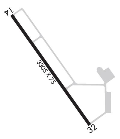
| Lat: N 4622.9 Long: W 09448.4 Elev: 1288 Var: -01 Longest Runway: 3305 | ||
| AWOS: 118.32 CTAF: 122.9 | ||
| ||||||||||||||||||||||||||||||||||||||||||||
| ||||||||||||||||||||||||||||||||||||||||||||
| ||||||||||||||||||||||||||||||||||||||||||||
| Rwy | Rwy | |||||||
| 3305x75 | 3305' | 3305x75 | 3305' | |||||
| Runway ID | Single Wheel | Double Wheel | Double Tandem Wheel | Dual Double Wheel |
| 14/32 | N/A | N/A | N/A | N/A |
| These numbers are Advisory and are not limits. The Airport Manager should have more accurate Weight Limits | ||||
 Airport Diagram might not be current. | |
| Facility Name: | STAPLES MUNI |
| City Name: | STAPLES |
| County: | WADENA |
| State abbrev: | MN |
| State Name: | MINNESOTA |
| Ownership: | PUBLICLY OWNED |
| Use: | OPEN TO THE PUBLIC |
| Owner's Name: | CITY OF STAPLES |
| Address: | 122 6TH ST NE |
| STAPLES, MN 56479-2900 | |
| Owner's Phone: | 218-894-2550 |
| Manager's Name: | JEREL NELSEN |
| Address: | 122 6TH ST NE |
| STAPLES, MN 56479-2900 | |
| Phone: | 218-894-2550 |
| FAA Region: | GREAT LAKES |
| FAA Field Office: | DMA |
| Date | Sunrise | Sunset |
|---|---|---|
| 06/08/26 Monday | 5:27 | 21:09 |
| 06/09/26 Tuesday | 5:27 | 21:10 |
| 06/10/26 Wednesday | 5:27 | 21:11 |
| 06/11/26 Thursday | 5:27 | 21:11 |
| 06/12/26 Friday | 5:26 | 21:12 |
| 06/13/26 Saturday | 5:26 | 21:12 |
| 06/14/26 Sunday | 5:26 | 21:13 |
| 06/15/26 Monday | 5:26 | 21:13 |
| 06/16/26 Tuesday | 5:26 | 21:14 |
| 06/17/26 Wednesday | 5:26 | 21:14 |
| 06/18/26 Thursday | 5:26 | 21:14 |
| 06/19/26 Friday | 5:26 | 21:15 |
| 06/20/26 Saturday | 5:26 | 21:15 |
| 06/21/26 Sunday | 5:27 | 21:15 |
| Airport Attendance Schedule | UNATTENDED |
| Airport Status | OPERATIONAL (This Status can change at any time - please check NOTAMS) |
| Airport Lighting Schedule | ACTVT REIL RWY 14 & 32; PAPI RWY 14 & 32; MIRL RWY 14/32 - CTAF. |
| Airport Storage Available | Tie Downs |
| Extra Services Available | Crop Dusting, Flight Instruction, Aircraft Rental, Aircraft Sales |
| Wind Indicator | YES - (lighted) |
| Control Tower | NO |
| CTAF Frequency | 122.900 |
| Unicom Frequency | |
| Rotating Beacon Color | WG |
| Segmented Circle | NO |
| Landing Fee | NO |
| Airport Inspected | STATE - performed by STATE AERONAUTICAL PERSONNEL |
| Inspection Date | 07/22/2025 |
| Type of Fuel Available | Grade 100LL; -10FUEL AVBL H24 SELF SVC VIA CREDIT CARD. |
| Airframe Repair Service | NONE |
| Power Plant Repair Service | NONE |
| Latitude | N4622.9 |
| Longitude | W09448.4 (ESTIMATED) |
| Arpt Elevation | 1287ft (SURVEYED) |
| Magnetic Variation | 01E |
| 2 miles NW | of STAPLES |
| Traffic Pattern Altitude | |
| Sectional Chart | TWIN CITIES |
| Operations (Reported) | Yearly | Avg. Daily |
|---|---|---|
| General Aviation Transient | 0 | 0 |
| General Aviation Local | 0 | 0 |
| Air Taxi | 0 | 0 |
| Commerical | 0 | 0 |
| Commuter | 0 | 0 |
| Military | 0 | 0 |
| Aircraft based on Field | |
|---|---|
| General Aviation Singles | 0 |
| General Aviation Multi | 0 |
| Jet Aircraft | 0 |
| General Aviation Helicopters | 0 |
| Military Aircraft | 0 |
| Gliders | 0 |
| Ultralights | 0 |
| FSS on field | NO |
| FSS tie-in | PRINCETON |
| FSS Phone | 1-800-WX-BRIEF |
| Who issues Notams | SAZ |
| Notam D service at airport | YES |
| ARTCC Name | MINNEAPOLIS |
| Airport Certification | |
| Aircraft Rescue & Firefighting Index | None |
| Airport of Entry | No |
| Custom Landing Rights | No |
| Joint Civil/Military | No |
| Military Landing rights | No |
| NATIONAL PLAN OF INTEGRATED AIRPORT SYSTEMS (NPIAS) |
| GCO AVBL ON FREQ 121.725 THRU MINNEAPOLIS ARTCC & FLT SVCS. |
| ULTRALIGHT TFC ON & INVOF ARPT. |
| FOR CD IF UNA VIA GCO CTC MINNEAPOLIS ARTCC AT 651-463-5588. |
Airport Communications & Frequencies:
| |||||||
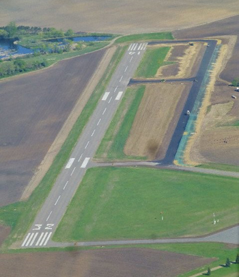
| Runway: 14 | Runway: 32 | ||
| Mag heading: | 144° | Mag heading: | 324° |
| Rwy Slope: | -.09% Down | Rwy Slope: | .09% Up |
| Approach: | Approach: | ||
| Pattern: | Left Traffic | Pattern: | Left Traffic |
| Markings: | NONPRECISION INSTRUMENT | Markings: | NONPRECISION INSTRUMENT |
| Marking Condition: | GOOD | Marking Condition: | GOOD |
| Arresting Dev: | Arresting Dev: | ||
| Lat & Long: | N4623.1 W09448.6 | Lat. & Long.: | N4622.6 W09448.2 |
| Elev: | 1287.5 ft. MSL | Elev: | 1284.6 ft. MSL |
| TCH: | 27 ft. AGL | TCH: | 27 ft. AGL |
| Visual Glide Path: | 3.00 degrees | Visual Glide Path: | 3.00 degrees |
| Displaced Threshold: | No | Displaced Threshold: | No |
| Touchdown Zone: | YES | Touchdown Zone: | YES |
| Touchdown Elev.: | 1287.6 feet | Touchdown Elev.: | 1287.4 feet |
| Visual Glide Slope: | 4-Light PAPI on LEFT side of Runway | Visual Glide Slope: | 4-Light PAPI on LEFT side of Runway |
| RVR Equipment: | RVR Equipment: | ||
| RVV Equipment: | NO | RVV Equipment: | NO |
| Approach Lights: | Approach Lights: | ||
| REIL: | YES | REIL: | YES |
| Centerline Lights: | NO | Centerline Lights: | NO |
| Touchdown lights: | NO | Touchdown lights: | NO |
| Runway Category: | Runway with a Non-precision Approach | Runway Category: | Runway with a Non-precision Approach |
| Declared Distances: | Declared Distances: | ||
| Obstructions: | TREE | Obstructions: | TREE |
| Marked: | NOT Marked/Lighted | Marked: | NOT Marked/Lighted |
| Clearance slope: | 3:1 | Clearance slope: | 17:1 |
| Obstruction height: | 24 feet AGL | Obstruction height: | 53 feet AGL |
| Dist. from runway: | 285 feet | Dist. from runway: | 1137 feet |
| Centerline offset: | 261 right of centerline | Centerline offset: | 291 feet right of centerline |
| Comments: | 7 FT BRUSH, 45 FT DIST, 189 FT R. | Comments: |
Thanks for using FltPlan.com
all rights reserved © 1999-2026 by Flight Plan LLC