| SAN ANTONIO INTL SAN ANTONIO TX |
| |
| Lat: N 2932.0 Long: W 09828.1 Elev: 809 Var: -04 Longest Runway: 8505 | ||
| Clr Del: 126.7 Dept. ATIS: 118.9 Arr. ATIS: 118.9 Ground: 121.9 Tower: 119.8 | ||

| |||||||||||||||||||||||||||||||||||||||||||||||||||||||||||||||||||||
| |||||||||||||||||||||||||||||||||||||||||||||||||||||||||||||||||||||
| |||||||||||||||||||||||||||||||||||||||||||||||||||||||||||||||||||||
| |||||||||||||||||||||||||||||||||||||||||||||||||||||||||||||||||||||
| |||||||||||||||||||||||||||||||||||||||||||||||||||||||||||||||||||||
| |||||||||||||||||||||||||||||||||||||||||||||||||||||||||||||||||||||
| |||||||||||||||||||||||||||||||||||||||||||||||||||||||||||||||||||||
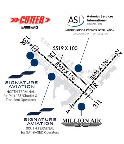
| Rwy | Rwy | |||||||
| 8505x150 | 8505' | 109.70 - 036° | 8505x150 | 8505' | ||||
| 5519x100 | 5519' | 5519x100 | 5519' | |||||
| 8502x150 | 8502' | 110.90 - 127° | 8502x150 | 8502' | 110.90 - 307° | |||
| Runway ID | Single Wheel | Double Wheel | Double Tandem Wheel | Dual Double Wheel |
| 04/22 | 95,000 | 190,000 | 270,000 | N/A |
| 13L/31R | 59,000 | 120,000 | N/A | N/A |
| 13R/31L | 95,000 | 190,000 | 270,000 | N/A |
| These numbers are Advisory and are not limits. The Airport Manager should have more accurate Weight Limits | ||||
 Airport Diagram might not be current. | |
| Facility Name: | SAN ANTONIO INTL |
| City Name: | SAN ANTONIO |
| County: | BEXAR |
| State abbrev: | TX |
| State Name: | TEXAS |
| Ownership: | PUBLICLY OWNED |
| Use: | OPEN TO THE PUBLIC |
| Owner's Name: | CITY OF SAN ANTONIO |
| Address: | 100 MILITARY PLAZA |
| SAN ANTONIO, TX 78207 | |
| Owner's Phone: | 210-207-7253 |
| Manager's Name: | JESUS H. SAENZ, JR. |
| Address: | 9800 AIRPORT BLVD |
| SAN ANTONIO, TX 78216 | |
| Phone: | 210-207-3444 |
| FAA Region: | SOUTHWEST |
| FAA Field Office: | TEX |
| Date | Sunrise | Sunset |
|---|---|---|
| 06/08/26 Monday | 6:33 | 20:33 |
| 06/09/26 Tuesday | 6:33 | 20:33 |
| 06/10/26 Wednesday | 6:33 | 20:33 |
| 06/11/26 Thursday | 6:33 | 20:34 |
| 06/12/26 Friday | 6:33 | 20:34 |
| 06/13/26 Saturday | 6:33 | 20:35 |
| 06/14/26 Sunday | 6:33 | 20:35 |
| 06/15/26 Monday | 6:33 | 20:35 |
| 06/16/26 Tuesday | 6:34 | 20:36 |
| 06/17/26 Wednesday | 6:34 | 20:36 |
| 06/18/26 Thursday | 6:34 | 20:36 |
| 06/19/26 Friday | 6:34 | 20:36 |
| 06/20/26 Saturday | 6:34 | 20:37 |
| 06/21/26 Sunday | 6:34 | 20:37 |
| Airport Attendance Schedule | CONTINUOUS |
| Airport Status | OPERATIONAL (This Status can change at any time - please check NOTAMS) |
| Airport Lighting Schedule | SS-SR |
| Airport Storage Available | Tie Downs, Hanger |
| Extra Services Available | Avionics, Cargo Handling, Charter, Flight Instruction, Aircraft Rental, Aircraft Sales |
| Wind Indicator | YES - (lighted) |
| Control Tower | YES |
| CTAF Frequency | |
| Unicom Frequency | 122.950 |
| Rotating Beacon Color | WG |
| Segmented Circle | NO |
| Landing Fee | YES |
| Airport Inspected | FEDERAL - performed by FAA AIRPORTS FIELD PERSONNEL |
| Inspection Date | 11/06/2025 |
| Type of Fuel Available | Grade 100LL, JET A (freeze point -40C) |
| Airframe Repair Service | MAJOR |
| Power Plant Repair Service | MAJOR |
| Latitude | N2932.0 |
| Longitude | W09828.1 (ESTIMATED) |
| Arpt Elevation | 809ft (SURVEYED) |
| Magnetic Variation | 04E |
| 7 miles N | of SAN ANTONIO |
| Traffic Pattern Altitude | |
| Sectional Chart | SAN ANTONIO |
| Operations (Reported) | Yearly | Avg. Daily |
|---|---|---|
| General Aviation Transient | 0 | 0 |
| General Aviation Local | 0 | 0 |
| Air Taxi | 0 | 0 |
| Commerical | 0 | 0 |
| Commuter | 0 | 0 |
| Military | 0 | 0 |
| Aircraft based on Field | |
|---|---|
| General Aviation Singles | 0 |
| General Aviation Multi | 0 |
| Jet Aircraft | 0 |
| General Aviation Helicopters | 0 |
| Military Aircraft | 0 |
| Gliders | 0 |
| Ultralights | 0 |
| FSS on field | NO |
| FSS tie-in | SAN ANGELO |
| FSS Phone | 1-800-WX-BRIEF |
| Who issues Notams | SAT |
| Notam D service at airport | YES |
| ARTCC Name | HOUSTON |
| Airport Certification | AIRPORT RECEIVING SCHEDULED AIR CARRIER SERVICE FROM CARRIERS CERTIFICATED BY THE CIVIL AERONAUTICS BOARD; SAT IS ARFF INDEX C; ARFF INDEX D AVBL WITH PPR. |
| Aircraft Rescue & Firefighting Index | AIRPORT HAS A CERTIFICATE UNDER CFR PART 139 |
| Airport of Entry | No |
| Custom Landing Rights | YES |
| Joint Civil/Military | No |
| Military Landing rights | YES |
| NATIONAL PLAN OF INTEGRATED AIRPORT SYSTEMS (NPIAS) |
| GRANT AGREEMENTS UNDER FAAP/ADAP/AIP |
| ASSURANCES PURSUANT TO TITLE VI, CIVIL RIGHTS ACT OF 1964 |
| SURPLUS PROPERTY AGREEMENT UNDER PUBLIC LAW 289 |
| AGREEMENT UNDER DLAND OR DCLA HAS EXPIRED. |
| GLIDER/SOARING OPNS APRXLY 17 MILES NW OF ARPT DURG VFR. |
| NOISE SENSITIVE AREAS EXIST ON ALL SIDES OF ARPT, AT PILOTS DISCRETION CLIMB AS QUICKLY AND QUIETLY AS SAFELY POSSIBLE ON DEPARTURE AND USE CONSIDERATION WHEN FLYING OVER POPULATED AREAS BY MINIMIZING FLT AND HIGH PWR SETTINGS. MILITARY AIRCRAFT: DEPARTING AND ARRIVING AIRCRAFT WILL USE MINIMUM POWER SETTINGS CONSISTENT WITH AIRCRAFT FLIGHT MANUALS, AFTERBURNER TAKEOFF IS PROHIBITED UNLESS REQUIRED FOR SAFETY OF FLIGHT. ENGINE-UPS ARE PERMITTED BTN 0600-2300. |
| ACFT TAXIING ON RY 04 NE BOUND LOOK FOR HOLD SHORT TO RY 31L. |
| ACFT TAXIING ON TWY N SW BOUND LOOK FOR HOLD SHORT TO RY 31R. |
| GROUND RUN-UP ENCLOSURE AVBL 24 HRS. |
| TERMINAL GATES A2, A6, A7, A8, USE ONLY WITH PPR CALL OPNS 210-413-4928. |
| THE FLWG TWYS ARE NOT AVBL FOR ACFT 59000 LBS OR OVR: TWY A, TWY M, TWY H NORTHWEST OF TWY Z AND TWY E EAST OF RWY 04/22. |
| TWY Z CLSD TO ACFT WITH WINGSPAN GREATER THAN 118 FT. |
| C130 AND C17 TYPE ACFT MUST PARK ON WEST RAMP TO CLR CUST. |
| INNER RAMP TAXILANE NORTH OF TRML A AND B IS CLSD TO ACFT WITH WINGSPAN GTR THAN 135 FT. |
| PPR WITH ARPT OPNS FOR ACFT POWERING BACK FM TERMINAL GATES. |
| TWYS L & B CLSD TO ACFT WITH WINGSPANS GREATER THAN 118 FT EXITING RY 31L. |
| ACFT AT TERMINAL A & B ADVISE GND CTL PRIOR TO PUSH. |
| TWY L CLSD NORTHBOUND. |
| ARPT RSTD TO ACFT WITH WINGSPAN GTR THAN 171 FT, PPR WITH 24HR OPS 210-413-4928. RQRD FOR AUTH. |
| APRON EAST CARGO RAMP INT OF RWY 04/22 AND TWY DELTA ACFT ARE REQ TO APPLY THE MNM THRUST WHEN XNG THE RWY TO AVOID DMG DUE TO JET BLAST. |
| ALL INTL GENERAL AVIATION CLEAR U.S. CSTMS AT NORTH FIXED BASE OPERATOR RAMP EAST SIDE, CALL U.S. CSTMS 210-821-6965 UPON ARR. |
| FOREIGN MIL ACFT WITH WINGSPAN LESS THAN 100 FT MUST REP TO GA RAMP FED INSPECTION STATION FOR CUST PROCESSING, CTC AP MANAGEMENT AT 210-207-3433. |
| NUMEROUS FLOCKS OF BIRDS INVOF ARPT. |
| RWY 13L/ 31RRWY 13L/31R NOT AVBL FOR PART 121/PART 380 OPS WITH SKED PAX CARRYING OPS MORE THAN 9 PAX SEATS AND NON-SKED PAX CARRYING OPS MORE THAN 30 PAX SEATS. |
| RWY 13R/ 31LRUNWAY HAS MET ITS SERVICE LIFE CYCLE AND IS IN NEED OF OVERHAUL. |
| RWY 04/2 2 PCR VALUE: 950/R/B/W/T |
| RWY 13L/ 31RPCR VALUE: 570/F/C/X/T |
| RWY 13R/ 31LPCR VALUE: 810/R/B/W/T |
Airport Communications & Frequencies:
| |||||||||||||||||||||||||||||||||||||||||||||||||||||||||||||||||||||||||||||||||||||||||||
| Runway: 04 | Runway: 22 | ||
| Mag heading: | 37° | Mag heading: | 217° |
| Rwy Slope: | -.37% Down | Rwy Slope: | .37% Up |
| Approach: | ILS/DME | Approach: | |
| Pattern: | Left Traffic | Pattern: | Left Traffic |
| Markings: | PRECISION INSTRUMENT | Markings: | PRECISION INSTRUMENT |
| Marking Condition: | GOOD | Marking Condition: | GOOD |
| Arresting Dev: | Arresting Dev: | ||
| Lat & Long: | N2931.4 W09828.2 | Lat. & Long.: | N2932.5 W09827.1 |
| Elev: | 786.0 ft. MSL | Elev: | 754.5 ft. MSL |
| TCH: | 79 ft. AGL | TCH: | 85 ft. AGL |
| Visual Glide Path: | 3.00 degrees | Visual Glide Path: | 3.00 degrees |
| Displaced Threshold: | No | Displaced Threshold: | No |
| Touchdown Zone: | YES | Touchdown Zone: | YES |
| Touchdown Elev.: | 786.0 feet | Touchdown Elev.: | 770.0 feet |
| Visual Glide Slope: | 4-Light PAPI on RIGHT side of Runway | Visual Glide Slope: | 4-Light PAPI on LEFT side of Runway |
| RVR Equipment: | TOUCHDOWN | RVR Equipment: | ROLLOUT |
| RVV Equipment: | NO | RVV Equipment: | NO |
| Approach Lights: | MALS - 1,400 foot medium intensity approach lighting system | Approach Lights: | |
| REIL: | NO | REIL: | YES |
| Centerline Lights: | YES | Centerline Lights: | YES |
| Touchdown lights: | NO | Touchdown lights: | NO |
| Runway Category: | Precision Instrument Runway | Runway Category: | Runway with a Non-precision Approach having visibility minimums greater than 3/4 mile |
| Declared Distances: | TORA:8505' TODA:8505' ASDA:8505' LDA:8505' | Declared Distances: | TORA:8505' TODA:8505' ASDA:8505' LDA:8505' |
| Obstructions: | POLE | Obstructions: | |
| Marked: | LIGHTED | Marked: | |
| Clearance slope: | 43:1 | Clearance slope: | 50:1 |
| Obstruction height: | 46 feet AGL | Obstruction height: | |
| Dist. from runway: | 2180 feet | Dist. from runway: | |
| Centerline offset: | 225 left of centerline | Centerline offset: | |
| Comments: | Comments: |
| Runway: 13L | Runway: 31R | ||
| Mag heading: | 128° | Mag heading: | 308° |
| Rwy Slope: | -.33% Down | Rwy Slope: | .33% Up |
| Approach: | Approach: | ||
| Pattern: | Left Traffic | Pattern: | Left Traffic |
| Markings: | NONPRECISION INSTRUMENT | Markings: | BASIC |
| Marking Condition: | GOOD | Marking Condition: | GOOD |
| Arresting Dev: | Arresting Dev: | ||
| Lat & Long: | N2932.4 W09828.7 | Lat. & Long.: | N2931.8 W09827.9 |
| Elev: | 797.3 ft. MSL | Elev: | 779.2 ft. MSL |
| TCH: | 40 ft. AGL | TCH: | 60 ft. AGL |
| Visual Glide Path: | 3.00 degrees | Visual Glide Path: | 3.00 degrees |
| Displaced Threshold: | No | Displaced Threshold: | No |
| Touchdown Zone: | YES | Touchdown Zone: | YES |
| Touchdown Elev.: | 797.3 feet | Touchdown Elev.: | 788.1 feet |
| Visual Glide Slope: | 4-Light PAPI on LEFT side of Runway | Visual Glide Slope: | 4-Light PAPI on LEFT side of Runway |
| RVR Equipment: | RVR Equipment: | ||
| RVV Equipment: | NO | RVV Equipment: | NO |
| Approach Lights: | Approach Lights: | ||
| REIL: | YES | REIL: | YES |
| Centerline Lights: | NO | Centerline Lights: | NO |
| Touchdown lights: | NO | Touchdown lights: | NO |
| Runway Category: | Runway with a Visual Approach | Runway Category: | Runway with a Visual Approach |
| Declared Distances: | TORA:5519' TODA:5519' ASDA:5519' LDA:5519' | Declared Distances: | TORA:5519' TODA:5519' ASDA:5519' LDA:5519' |
| Runway: 13R | Runway: 31L | ||
| Mag heading: | 128° | Mag heading: | 308° |
| Rwy Slope: | -.36% Down | Rwy Slope: | .36% Up |
| Approach: | ILS/DME | Approach: | ILS/DME |
| Pattern: | Left Traffic | Pattern: | Left Traffic |
| Markings: | PRECISION INSTRUMENT | Markings: | PRECISION INSTRUMENT |
| Marking Condition: | GOOD | Marking Condition: | GOOD |
| Arresting Dev: | Arresting Dev: | ||
| Lat & Long: | N2932.6 W09829.1 | Lat. & Long.: | N2931.6 W09827.9 |
| Elev: | 809.1 ft. MSL | Elev: | 778.5 ft. MSL |
| TCH: | 75 ft. AGL | TCH: | 82 ft. AGL |
| Visual Glide Path: | 3.00 degrees | Visual Glide Path: | 3.00 degrees |
| Displaced Threshold: | No | Displaced Threshold: | No |
| Touchdown Zone: | YES | Touchdown Zone: | YES |
| Touchdown Elev.: | 809.1 feet | Touchdown Elev.: | 790.0 feet |
| Visual Glide Slope: | 4-Light PAPI on LEFT side of Runway | Visual Glide Slope: | 4-Light PAPI on LEFT side of Runway |
| RVR Equipment: | TOUCHDOWN-MIDFIELD-ROLLOUT | RVR Equipment: | TOUCHDOWN-MIDFIELD-ROLLOUT |
| RVV Equipment: | NO | RVV Equipment: | NO |
| Approach Lights: | ALSF2 - standard 2,400 foot high intensity approach lighting system with sequenced flashers, Category II or III | Approach Lights: | MALSR - 1,400 foot medium intensity approach lighting system with runway alignment indicator lights |
| REIL: | NO | REIL: | NO |
| Centerline Lights: | YES | Centerline Lights: | YES |
| Touchdown lights: | YES | Touchdown lights: | NO |
| Runway Category: | Precision Instrument Runway | Runway Category: | Precision Instrument Runway |
| Declared Distances: | TORA:8502' TODA:8502' ASDA:8502' LDA:8502' | Declared Distances: | TORA:8502' TODA:8502' ASDA:8502' LDA:8502' |
| Obstructions: | Obstructions: | BLDG | |
| Marked: | Marked: | NOT Marked/Lighted | |
| Clearance slope: | 50:1 | Clearance slope: | 41:1 |
| Obstruction height: | Obstruction height: | 79 feet AGL | |
| Dist. from runway: | Dist. from runway: | 3500 feet | |
| Centerline offset: | Centerline offset: | 300 feet right of centerline | |
| Comments: | Comments: |
Thanks for using FltPlan.com
all rights reserved © 1999-2026 by Flight Plan LLC