
| SACRAMENTO EXECUTIVE SACRAMENTO CA |
| |
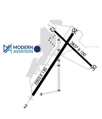
| Lat: N 3830.8 Long: W 12129.6 Elev: 24 Var: -14 Longest Runway: 5503 | ||
| Dept. ATIS: 125.5 Arr. ATIS: 125.5 Ground: 125.0 Tower: 119.5 | ||

| ||||||||||||||||||||||||||||||||||||||||||||
| ||||||||||||||||||||||||||||||||||||||||||||
| ||||||||||||||||||||||||||||||||||||||||||||
| ||||||||||||||||||||||||||||||||||||||||||||
| ||||||||||||||||||||||||||||||||||||||||||||
| ||||||||||||||||||||||||||||||||||||||||||||
| FBOs at nearby airports who want your business: | |||||||||||
| |||||||||||
| Rwy | Rwy | |||||||
| 5503x150 | 5503' | 110.30 - 019° | 5503x150 | 5503' | ||||
| 3837x100 | 3837' | 3837x100 | 3837' | |||||
| Runway ID | Single Wheel | Double Wheel | Double Tandem Wheel | Dual Double Wheel |
| 02/20 | 60,000 | 130,000 | 210,000 | N/A |
| 12/30 | 30,000 | 43,000 | 67,000 | N/A |
| H1 | N/A | N/A | N/A | N/A |
| These numbers are Advisory and are not limits. The Airport Manager should have more accurate Weight Limits | ||||
 Airport Diagram might not be current. | |
| Facility Name: | SACRAMENTO EXEC |
| City Name: | SACRAMENTO |
| County: | SACRAMENTO |
| State abbrev: | CA |
| State Name: | CALIFORNIA |
| Ownership: | PUBLICLY OWNED |
| Use: | OPEN TO THE PUBLIC |
| Owner's Name: | CITY OF SACRAMENTO; OPERATED BY CO OF SACRAMENTO |
| Address: | 6151 FREEPORT BLVD. |
| SACRAMENTO, CA 95322-3518 | |
| Owner's Phone: | 916-929-5411 |
| Manager's Name: | PHILLIP BENEDETTO |
| Address: | 6151 FREEPORT BLVD |
| SACRAMENTO, CA 95822 | |
| Phone: | 916-875-9035; APT MGR HRS 0800-1630 M-F |
| FAA Region: | WESTERN-PACIFIC |
| FAA Field Office: | SFO |
| Date | Sunrise | Sunset |
|---|---|---|
| 09/24/21 Friday | 6:55 | 19:00 |
| 09/25/21 Saturday | 6:56 | 18:58 |
| 09/26/21 Sunday | 6:57 | 18:57 |
| 09/27/21 Monday | 6:58 | 18:55 |
| 09/28/21 Tuesday | 6:59 | 18:54 |
| 09/29/21 Wednesday | 7:00 | 18:52 |
| 09/30/21 Thursday | 7:01 | 18:51 |
| 10/01/21 Friday | 7:02 | 18:49 |
| 10/02/21 Saturday | 7:03 | 18:47 |
| 10/03/21 Sunday | 7:03 | 18:46 |
| 10/04/21 Monday | 7:04 | 18:44 |
| 10/05/21 Tuesday | 7:05 | 18:43 |
| 10/06/21 Wednesday | 7:06 | 18:41 |
| 10/07/21 Thursday | 7:07 | 18:40 |
| Airport Attendance Schedule | 7 Days A Week 0800-1600 |
| Airport Status | OPERATIONAL (This Status can change at any time - please check NOTAMS) |
| Airport Lighting Schedule | DUSK-DAWN. WHEN ATCT CLSD ACTVT ALL AIRFIELD LGTS - CTAF.; DUSK-DAWN. WHEN ATCT CLSD ACTVT APT BCN - CTAF |
| Airport Storage Available | Tie Downs |
| Extra Services Available | Air Freight, Air Ambulance, Avionics, Charter, Flight Instruction, Aircraft Rental, Aircraft Sales, Annual Surveying |
| Wind Indicator | YES - (lighted) |
| Control Tower | YES |
| CTAF Frequency | 119.500 |
| Unicom Frequency | 122.950 |
| Rotating Beacon Color | CLEAR-GREEN (Light Land Airport) |
| Segmented Circle | YES |
| Landing Fee | NO |
| Airport Inspected | STATE - performed by STATE AERONAUTICAL PERSONNEL |
| Inspection Date | 01/23/2020 |
| Type of Fuel Available | Grade 100LL, JET A (freeze point -40C) |
| Airframe Repair Service | MAJOR |
| Power Plant Repair Service | MAJOR |
| Latitude | N3830.8 |
| Longitude | W12129.6 (ESTIMATED) |
| Arpt Elevation | 23ft (SURVEYED) |
| Magnetic Variation | 14E |
| 3 miles S | of SACRAMENTO |
| Traffic Pattern Altitude | |
| Sectional Chart | SAN FRANCISCO |
| Operations (Reported) | Yearly | Avg. Daily |
|---|---|---|
| General Aviation Transient | 72869 | 200 |
| General Aviation Local | 35901 | 98 |
| Air Taxi | 2202 | 6 |
| Commerical | 0 | 0 |
| Commuter | 0 | 0 |
| Military | 96 | 0 |
| Aircraft based on Field | |
|---|---|
| General Aviation Singles | 149 |
| General Aviation Multi | 18 |
| Jet Aircraft | 4 |
| General Aviation Helicopters | 0 |
| Military Aircraft | 0 |
| Gliders | 1 |
| Ultralights | 0 |
| FSS on field | NO |
| FSS tie-in | RANCHO MURIETA |
| FSS Phone | 1-800-WX-BRIEF |
| Who issues Notams | SAC |
| Notam D service at airport | YES |
| ARTCC Name | OAKLAND |
| Airport Certification | |
| Aircraft Rescue & Firefighting Index | None |
| Airport of Entry | No |
| Custom Landing Rights | No |
| Joint Civil/Military | No |
| Military Landing rights | YES |
| NATIONAL PLAN OF INTEGRATED AIRPORT SYSTEMS (NPIAS) |
| GRANT AGREEMENTS UNDER FAAP/ADAP/AIP |
| SURPLUS PROPERTY AGREEMENT UNDER PUBLIC LAW 289 |
| ASSURANCES PURSUANT TO TITLE VI, CIVIL RIGHTS ACT OF 1964 |
| AGREEMENT UNDER DLAND OR DCLA HAS EXPIRED. |
| RY 20 CALM WIND RY. |
| NO TOUCH & GO LNDGS, LOW APPCHS OR PRACTICE INST APPCHS BTN HRS 2100-0600 LOCAL; FOR MORE INFO CALL (916) 874-0359. |
| BIRDS INVOF OF APRT. |
| DITCH AND CONCRETE BRIDGE IN RY 02/20 SAFETY AREA LCTD 500 FT PRIOR TO RY 02 THLD ON CL. |
| ARPT NOISE ABATEMENT PROCEDURES IN EFFECT 2100-0600 FOR MORE INFO CALL (916) 875-9037 OR (916) 875-9035. |
| ARPT 24HR EMERGENCY 916-929-5000. |
| PRIOR PERMISSION FROM AIRPORT OPERATOR REQUIRED FOR ACFT OVER 50,000 LBS MAX TAKEOFF WEIGHT. |
| DSTC BTN TWY A AND TWY B CNTRLN IS 75 FT. |
| RWY 12 BLAST PAD MARKINGS NOT STD. |
| FOR CD WHEN ATCT IS CLSD CTC NORCAL APCH AT 916-361-6874. |
| GOLF COURSE LGTS SHINE ACROSS RY 02 FINAL APCH 800 FT RY CL DUSK TO 2200. |
| NO MID-FIELD, INTERSECTION OR FORMATION TKOFS. |
Airport Communications & Frequencies:
| ||||||||||||||||||||||||||||||
| Runway: 02 | Runway: 20 | ||
| Mag heading: | 19° | Mag heading: | 199° |
| Rwy Slope: | .11% Up | Rwy Slope: | -.11% Down |
| Approach: | ILS | Approach: | |
| Pattern: | Left Traffic | Pattern: | Left Traffic |
| Markings: | PRECISION INSTRUMENT | Markings: | PRECISION INSTRUMENT |
| Marking Condition: | GOOD | Marking Condition: | GOOD |
| Arresting Dev: | Arresting Dev: | ||
| Lat & Long: | N3830.3 W12130.0 | Lat. & Long.: | N3831.1 W12129.4 |
| Elev: | 17.3 ft. MSL | Elev: | 23.5 ft. MSL |
| TCH: | TCH: | 36 ft. AGL | |
| Visual Glide Path: | Visual Glide Path: | 3.00 degrees | |
| Displaced Threshold: | No | Displaced Threshold: | No |
| Touchdown Zone: | YES | Touchdown Zone: | YES |
| Touchdown Elev.: | 21.1 feet | Touchdown Elev.: | 23.5 feet |
| Visual Glide Slope: | Visual Glide Slope: | 4-Light PAPI on LEFT side of Runway | |
| RVR Equipment: | RVR Equipment: | ||
| RVV Equipment: | YES | RVV Equipment: | NO |
| Approach Lights: | MALSR - 1,400 foot medium intensity approach lighting system with runway alignment indicator lights | Approach Lights: | |
| REIL: | NO | REIL: | YES |
| Centerline Lights: | NO | Centerline Lights: | NO |
| Touchdown lights: | NO | Touchdown lights: | NO |
| Runway Category: | Precision Instrument Runway | Runway Category: | Runway with a Visual Approach |
| Declared Distances: | Declared Distances: | ||
| Obstructions: | TREE | Obstructions: | TREE |
| Marked: | NOT Marked/Lighted | Marked: | NOT Marked/Lighted |
| Clearance slope: | 34:1 | Clearance slope: | 30:1 |
| Obstruction height: | 33 feet AGL | Obstruction height: | 40 feet AGL |
| Dist. from runway: | 1350 feet | Dist. from runway: | 1430 feet |
| Centerline offset: | 275 right of centerline | Centerline offset: | 250 feet right of centerline |
| Comments: | Comments: |
| Runway: 12 | Runway: 30 | ||
| Mag heading: | 119° | Mag heading: | 299° |
| Rwy Slope: | .02% Up | Rwy Slope: | -.02% Down |
| Approach: | Approach: | ||
| Pattern: | Left Traffic | Pattern: | Left Traffic |
| Markings: | BASIC | Markings: | BASIC |
| Marking Condition: | GOOD | Marking Condition: | GOOD |
| Arresting Dev: | Arresting Dev: | ||
| Lat & Long: | N3831.1 W12129.7 | Lat. & Long.: | N3830.7 W12129.1 |
| Elev: | 22.7 ft. MSL | Elev: | 23.4 ft. MSL |
| TCH: | 50 ft. AGL | TCH: | 50 ft. AGL |
| Visual Glide Path: | 3.00 degrees | Visual Glide Path: | 3.50 degrees |
| Displaced Threshold: | No | Displaced Threshold: | No |
| Touchdown Zone: | YES | Touchdown Zone: | YES |
| Touchdown Elev.: | 23.6 feet | Touchdown Elev.: | 23.6 feet |
| Visual Glide Slope: | 4-Light PAPI on LEFT side of Runway | Visual Glide Slope: | 4-Light PAPI on LEFT side of Runway |
| RVR Equipment: | RVR Equipment: | ||
| RVV Equipment: | NO | RVV Equipment: | NO |
| Approach Lights: | Approach Lights: | ||
| REIL: | YES | REIL: | YES |
| Centerline Lights: | NO | Centerline Lights: | NO |
| Touchdown lights: | NO | Touchdown lights: | NO |
| Runway Category: | Runway with a Visual Approach | Runway Category: | Runway with a Visual Approach |
| Declared Distances: | Declared Distances: | ||
| Obstructions: | TREE | Obstructions: | TREE |
| Marked: | NOT Marked/Lighted | Marked: | NOT Marked/Lighted |
| Clearance slope: | 25:1 | Clearance slope: | 17:1 |
| Obstruction height: | 40 feet AGL | Obstruction height: | 50 feet AGL |
| Dist. from runway: | 1200 feet | Dist. from runway: | 1050 feet |
| Centerline offset: | 201 right of centerline | Centerline offset: | 100 feet left of centerline |
| Comments: | Comments: |
Thanks for using FltPlan.com
all rights reserved © 1999-2021 by Flight Plan LLC