
| SPRINGER MUNI SPRINGER NM |
| |
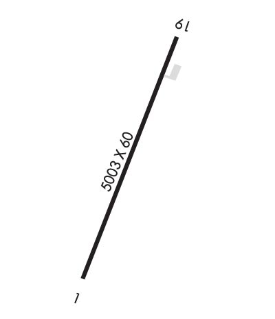
| Lat: N 3619.9 Long: W 10437.1 Elev: 5894 Var: -11 Longest Runway: 5003 | ||
| CTAF: 122.9 | ||
| ||||||||||||||||||||||||||||||||
| ||||||||||||||||||||||||||||||||
| Rwy | Rwy | |||||||
| 5003x60 | 5003' | 5003x60 | 5003' | |||||
| Runway ID | Single Wheel | Double Wheel | Double Tandem Wheel | Dual Double Wheel |
| 01/19 | 8,500 | N/A | N/A | N/A |
| These numbers are Advisory and are not limits. The Airport Manager should have more accurate Weight Limits | ||||
| FltPlan does not have IFR approach charts available for KS42. |
 Airport Diagram might not be current. | |
| Facility Name: | SPRINGER MUNI |
| City Name: | SPRINGER |
| County: | COLFAX |
| State abbrev: | NM |
| State Name: | NEW MEXICO |
| Ownership: | PUBLICLY OWNED |
| Use: | OPEN TO THE PUBLIC |
| Owner's Name: | TOWN OF SPRINGER |
| Address: | PO BOX 488 |
| SPRINGER, NM 87747 | |
| Owner's Phone: | 575-483-2682 |
| Manager's Name: | CRAIG EPPLER; FIELD OPS SUPERVISOR. |
| Address: | P.O. BOX 488 |
| SPRINGER, NM 87747 | |
| Phone: | 575-483-2321; EMERGENCY CONTACT 575-707-0265. |
| FAA Region: | SOUTHWEST |
| FAA Field Office: | LNM |
| Date | Sunrise | Sunset |
|---|---|---|
| 09/24/21 Friday | 6:48 | 18:53 |
| 09/25/21 Saturday | 6:49 | 18:51 |
| 09/26/21 Sunday | 6:49 | 18:50 |
| 09/27/21 Monday | 6:50 | 18:48 |
| 09/28/21 Tuesday | 6:51 | 18:47 |
| 09/29/21 Wednesday | 6:52 | 18:45 |
| 09/30/21 Thursday | 6:53 | 18:44 |
| 10/01/21 Friday | 6:53 | 18:42 |
| 10/02/21 Saturday | 6:54 | 18:41 |
| 10/03/21 Sunday | 6:55 | 18:39 |
| 10/04/21 Monday | 6:56 | 18:38 |
| 10/05/21 Tuesday | 6:57 | 18:36 |
| 10/06/21 Wednesday | 6:58 | 18:35 |
| 10/07/21 Thursday | 6:58 | 18:34 |
| Airport Attendance Schedule | UNATTENDED |
| Airport Status | OPERATIONAL (This Status can change at any time - please check NOTAMS) |
| Airport Lighting Schedule | MIRL RWY 01/19 PRESET LOW INTST - TO INCREASE INTST ACTVT - CTAF. |
| Airport Storage Available | Tie Downs |
| Extra Services Available | NONE |
| Wind Indicator | YES - (lighted) |
| Control Tower | NO |
| CTAF Frequency | 122.900 |
| Unicom Frequency | |
| Rotating Beacon Color | CLEAR-GREEN (Light Land Airport) |
| Segmented Circle | YES |
| Landing Fee | NO |
| Airport Inspected | STATE - performed by PRIVATE CONTRACT PERSONNEL |
| Inspection Date | 04/08/2019 |
| Type of Fuel Available | None |
| Airframe Repair Service | NONE |
| Power Plant Repair Service | NONE |
| Latitude | N3619.9 |
| Longitude | W10437.1 (ESTIMATED) |
| Arpt Elevation | 5894ft (SURVEYED) |
| Magnetic Variation | 11E |
| 1 miles S | of SPRINGER |
| Traffic Pattern Altitude | |
| Sectional Chart | DENVER |
| Operations (Reported) | Yearly | Avg. Daily |
|---|---|---|
| General Aviation Transient | 20 | 0 |
| General Aviation Local | 0 | 0 |
| Air Taxi | 0 | 0 |
| Commerical | 0 | 0 |
| Commuter | 0 | 0 |
| Military | 10 | 0 |
| Aircraft based on Field | |
|---|---|
| General Aviation Singles | 0 |
| General Aviation Multi | 0 |
| Jet Aircraft | 0 |
| General Aviation Helicopters | 0 |
| Military Aircraft | 0 |
| Gliders | 0 |
| Ultralights | 0 |
| FSS on field | NO |
| FSS tie-in | ALBUQUERQUE; ALBUQUERQUE FSS CALL 800-525-9963. |
| FSS Phone | 1-800-WX-BRIEF |
| Who issues Notams | ABQ |
| Notam D service at airport | YES |
| ARTCC Name | ALBUQUERQUE |
| Airport Certification | |
| Aircraft Rescue & Firefighting Index | None |
| Airport of Entry | No |
| Custom Landing Rights | No |
| Joint Civil/Military | No |
| Military Landing rights | YES |
| NATIONAL PLAN OF INTEGRATED AIRPORT SYSTEMS (NPIAS) |
| GRANT AGREEMENTS UNDER FAAP/ADAP/AIP |
| ASSURANCES PURSUANT TO TITLE VI, CIVIL RIGHTS ACT OF 1964 |
| RY ARPT ROAD GATES LOCKED; FOR ENTRY & EXIT CALL 575-483-2321 EXTENSION 217 BEFORE ARRIVAL. NO PHONE ON ARPT. |
| RY 19 3-10 FT DROP OFF 30 FT FM RY EDGE WEST SIDE 1ST 300 FT FM THLD. |
| WILDLIFE ON AND IN VICINITY OF AIRPORT. |
| FOR CD CTC ALBUQUERQUE ARTCC AT 505-856-4861. |
| Runway: 01 | Runway: 19 | ||
| Mag heading: | 9° | Mag heading: | 189° |
| Rwy Slope: | .34% Up | Rwy Slope: | -.34% Down |
| Approach: | Approach: | ||
| Pattern: | Left Traffic | Pattern: | Left Traffic |
| Markings: | NONPRECISION INSTRUMENT | Markings: | NONPRECISION INSTRUMENT |
| Marking Condition: | GOOD | Marking Condition: | GOOD |
| Arresting Dev: | Arresting Dev: | ||
| Lat & Long: | N3619.5 W10437.2 | Lat. & Long.: | N3620.3 W10436.9 |
| Elev: | 5877.0 ft. MSL | Elev: | 5894.0 ft. MSL |
| TCH: | TCH: | ||
| Visual Glide Path: | Visual Glide Path: | ||
| Displaced Threshold: | No | Displaced Threshold: | No |
| Touchdown Zone: | YES | Touchdown Zone: | YES |
| Touchdown Elev.: | 5877.0 feet | Touchdown Elev.: | 5894.0 feet |
| Visual Glide Slope: | Visual Glide Slope: | ||
| RVR Equipment: | RVR Equipment: | ||
| RVV Equipment: | NO | RVV Equipment: | NO |
| Approach Lights: | Approach Lights: | ||
| REIL: | NO | REIL: | NO |
| Centerline Lights: | NO | Centerline Lights: | NO |
| Touchdown lights: | NO | Touchdown lights: | NO |
| Runway Category: | Runway with a Visual Approach | Runway Category: | Runway with a Visual Approach |
| Declared Distances: | Declared Distances: | ||
| Obstructions: | HILL | Obstructions: | |
| Marked: | NOT Marked/Lighted | Marked: | |
| Clearance slope: | 44:1 | Clearance slope: | 50:1 |
| Obstruction height: | 18 feet AGL | Obstruction height: | |
| Dist. from runway: | 1000 feet | Dist. from runway: | |
| Centerline offset: | Centerline offset: | ||
| Comments: | Comments: |
Thanks for using FltPlan.com
all rights reserved © 1999-2021 by Flight Plan LLC
