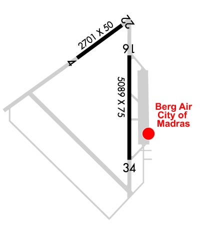
| MADRAS MUNICIPAL MADRAS OR |
| |
| Lat: N 4440.2 Long: W 12109.3 Elev: 2438 Var: -16 Longest Runway: 5091 | ||
| AWOS: 132.42 CTAF: 122.8 | ||
| |||||||||||||||||||||||||||||||||||||||||||||||||||||||||||||
| |||||||||||||||||||||||||||||||||||||||||||||||||||||||||||||
| |||||||||||||||||||||||||||||||||||||||||||||||||||||||||||||
| Rwy | Rwy | |||||||
| 2701x50 | 2701' | 2701x50 | 2701' | |||||
| 5091x75 | 5091' | 5091x75 | 5091' | |||||
| Runway ID | Single Wheel | Double Wheel | Double Tandem Wheel | Dual Double Wheel |
| 04/22 | 16,000 | N/A | N/A | N/A |
| 16/34 | 75,000 | 120,000 | 180,000 | N/A |
| These numbers are Advisory and are not limits. The Airport Manager should have more accurate Weight Limits | ||||
 Airport Diagram might not be current. | |
| Facility Name: | MADRAS MUNI |
| City Name: | MADRAS |
| County: | JEFFERSON |
| State abbrev: | OR |
| State Name: | OREGON |
| Ownership: | PUBLICLY OWNED |
| Use: | OPEN TO THE PUBLIC |
| Owner's Name: | CITY |
| Address: | 71 SE D ST, CITY HALL |
| MADRAS, OR 97741 | |
| Owner's Phone: | 541-475-2344 |
| Manager's Name: | ROB BERG |
| Address: | 2028 NW AIRPORT WAY |
| MADRAS, OR 97741 | |
| Phone: | 541-475-6947 |
| FAA Region: | NORTHWEST MOUNTAIN |
| FAA Field Office: | SEA |
| Date | Sunrise | Sunset |
|---|---|---|
| 09/24/21 Friday | 6:54 | 18:59 |
| 09/25/21 Saturday | 6:55 | 18:57 |
| 09/26/21 Sunday | 6:56 | 18:55 |
| 09/27/21 Monday | 6:57 | 18:53 |
| 09/28/21 Tuesday | 6:59 | 18:51 |
| 09/29/21 Wednesday | 7:00 | 18:49 |
| 09/30/21 Thursday | 7:01 | 18:47 |
| 10/01/21 Friday | 7:02 | 18:45 |
| 10/02/21 Saturday | 7:04 | 18:44 |
| 10/03/21 Sunday | 7:05 | 18:42 |
| 10/04/21 Monday | 7:06 | 18:40 |
| 10/05/21 Tuesday | 7:07 | 18:38 |
| 10/06/21 Wednesday | 7:08 | 18:36 |
| 10/07/21 Thursday | 7:10 | 18:34 |
| Airport Attendance Schedule | NOV-APR 7 Days A Week 0800-1700, MAY-OCT 7 Days A Week 0800-1800 |
| Airport Status | OPERATIONAL (This Status can change at any time - please check NOTAMS) |
| Airport Lighting Schedule | ACTVT REIL RWY 34; VASI RWY 34; MRIL RWY 16/34 - CTAF |
| Airport Storage Available | Tie Downs, Hanger |
| Extra Services Available | Crop Dusting, Charter, Flight Instruction, Parachute Jumping, Aircraft Rental |
| Wind Indicator | YES - (lighted) |
| Control Tower | NO |
| CTAF Frequency | 122.800 |
| Unicom Frequency | 122.800 |
| Rotating Beacon Color | CLEAR-GREEN (Light Land Airport) |
| Segmented Circle | NO |
| Landing Fee | NO |
| Airport Inspected | STATE - performed by STATE AERONAUTICAL PERSONNEL |
| Inspection Date | 08/28/2019 |
| Type of Fuel Available | Grade 100LL, JET A (freeze point -40C) |
| Airframe Repair Service | MAJOR |
| Power Plant Repair Service | MAJOR |
| Latitude | N4440.2 |
| Longitude | W12109.3 (ESTIMATED) |
| Arpt Elevation | 2437ft (SURVEYED) |
| Magnetic Variation | 16E |
| 3 miles NW | of MADRAS |
| Traffic Pattern Altitude | |
| Sectional Chart | SEATTLE |
| Operations (Reported) | Yearly | Avg. Daily |
|---|---|---|
| General Aviation Transient | 4035 | 11 |
| General Aviation Local | 6000 | 16 |
| Air Taxi | 600 | 2 |
| Commerical | 0 | 0 |
| Commuter | 0 | 0 |
| Military | 100 | 0 |
| Aircraft based on Field | |
|---|---|
| General Aviation Singles | 38 |
| General Aviation Multi | 7 |
| Jet Aircraft | 8 |
| General Aviation Helicopters | 1 |
| Military Aircraft | 0 |
| Gliders | 0 |
| Ultralights | 0 |
| FSS on field | NO |
| FSS tie-in | MC MINNVILLE |
| FSS Phone | 1-800-WX-BRIEF |
| Who issues Notams | MMV |
| Notam D service at airport | YES |
| ARTCC Name | SEATTLE |
| Airport Certification | |
| Aircraft Rescue & Firefighting Index | None |
| Airport of Entry | No |
| Custom Landing Rights | No |
| Joint Civil/Military | No |
| Military Landing rights | YES |
| NATIONAL PLAN OF INTEGRATED AIRPORT SYSTEMS (NPIAS) |
| GRANT AGREEMENTS UNDER FAAP/ADAP/AIP |
| SURPLUS PROPERTY AGREEMENT UNDER PUBLIC LAW 289 |
| ASSURANCES PURSUANT TO TITLE VI, CIVIL RIGHTS ACT OF 1964 |
| DEER, COYOTE AND COUGAR ON & INVOF ARPT. |
| FOR CD CTC SEATTLE ARTCC AT 253-351-3694. |
Airport Communications & Frequencies:
| |||||||||
| Runway: 04 | Runway: 22 | ||
| Mag heading: | 39° | Mag heading: | 219° |
| Rwy Slope: | .29% Up | Rwy Slope: | -.29% Down |
| Approach: | Approach: | ||
| Pattern: | Left Traffic | Pattern: | Left Traffic |
| Markings: | BASIC | Markings: | BASIC |
| Marking Condition: | FAIR; RY 04/22 MKD WITH WHITE REFLECTORS. | Marking Condition: | FAIR |
| Arresting Dev: | Arresting Dev: | ||
| Lat & Long: | N4440.4 W12109.8 | Lat. & Long.: | N4440.7 W12109.3 |
| Elev: | 2417.0 ft. MSL | Elev: | 2424.7 ft. MSL |
| TCH: | TCH: | ||
| Visual Glide Path: | Visual Glide Path: | ||
| Displaced Threshold: | No | Displaced Threshold: | No |
| Touchdown Zone: | YES | Touchdown Zone: | YES |
| Touchdown Elev.: | 2424.7 feet | Touchdown Elev.: | 2424.7 feet |
| Visual Glide Slope: | Visual Glide Slope: | ||
| RVR Equipment: | RVR Equipment: | ||
| RVV Equipment: | NO | RVV Equipment: | NO |
| Approach Lights: | Approach Lights: | ||
| REIL: | NO | REIL: | NO |
| Centerline Lights: | NO | Centerline Lights: | NO |
| Touchdown lights: | NO | Touchdown lights: | NO |
| Runway Category: | Runway with a Visual Approach | Runway Category: | Runway with a Visual Approach |
| Declared Distances: | Declared Distances: | ||
| Obstructions: | Obstructions: | ROAD | |
| Marked: | Marked: | NOT Marked/Lighted | |
| Clearance slope: | 50:1 | Clearance slope: | |
| Obstruction height: | Obstruction height: | 15 feet AGL | |
| Dist. from runway: | Dist. from runway: | 200 feet | |
| Centerline offset: | Centerline offset: | 240 feet right of centerline | |
| Comments: | Comments: | +5 FT FENCE 190 FT FM RY END 228 FT R. |
| Runway: 16 | Runway: 34 | ||
| Mag heading: | 164° | Mag heading: | 344° |
| Rwy Slope: | .14% Up | Rwy Slope: | -.14% Down |
| Approach: | Approach: | ||
| Pattern: | Left Traffic | Pattern: | Left Traffic |
| Markings: | BASIC | Markings: | BASIC |
| Marking Condition: | GOOD | Marking Condition: | GOOD |
| Arresting Dev: | Arresting Dev: | ||
| Lat & Long: | N4440.4 W12109.2 | Lat. & Long.: | N4439.6 W12109.2 |
| Elev: | 2430.3 ft. MSL | Elev: | 2437.4 ft. MSL |
| TCH: | TCH: | 50 ft. AGL | |
| Visual Glide Path: | Visual Glide Path: | 3.00 degrees | |
| Displaced Threshold: | No | Displaced Threshold: | No |
| Touchdown Zone: | YES | Touchdown Zone: | YES |
| Touchdown Elev.: | 2433.9 feet | Touchdown Elev.: | 2437.6 feet |
| Visual Glide Slope: | Visual Glide Slope: | 4-BOX VASI ON LEFT SIDE OF RUNWAY | |
| RVR Equipment: | RVR Equipment: | ||
| RVV Equipment: | NO | RVV Equipment: | NO |
| Approach Lights: | Approach Lights: | ||
| REIL: | NO | REIL: | YES |
| Centerline Lights: | NO | Centerline Lights: | NO |
| Touchdown lights: | NO | Touchdown lights: | NO |
| Runway Category: | Runway with a Non-precision Approach having visibility minimums greater than 3/4 mile | Runway Category: | Runway with a Non-precision Approach having visibility minimums greater than 3/4 mile |
| Declared Distances: | Declared Distances: |
Thanks for using FltPlan.com
all rights reserved © 1999-2021 by Flight Plan LLC