
| INTL PEACE GARDEN DUNSEITH ND |
| |
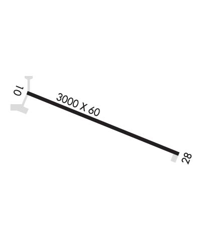
| Lat: N 4859.8 Long: W 10002.6 Elev: 2317 Var: -09 Longest Runway: 3005 | ||
| CTAF: 122.8 | ||
| ||||||||||||||||||||||||||||||||
| ||||||||||||||||||||||||||||||||
| Rwy | Rwy | |||||||
| 3005x60 | 3005' | 3005x60 | 3005' | |||||
| Runway ID | Single Wheel | Double Wheel | Double Tandem Wheel | Dual Double Wheel |
| 11/29 | 12,500 | N/A | N/A | N/A |
| These numbers are Advisory and are not limits. The Airport Manager should have more accurate Weight Limits | ||||
| FltPlan does not have IFR approach charts available for KS28. |
 Airport Diagram might not be current. | |
| Facility Name: | INTL PEACE GARDEN |
| City Name: | DUNSEITH |
| County: | ROLETTE |
| State abbrev: | ND |
| State Name: | NORTH DAKOTA |
| Ownership: | PUBLICLY OWNED |
| Use: | OPEN TO THE PUBLIC |
| Owner's Name: | NORTH DAKOTA STATE AERO COMMISSION |
| Address: | PO BOX 5020 |
| BISMARCK, ND 58502 | |
| Owner's Phone: | 701-328-9650 |
| Manager's Name: | KYLE WANNER |
| Address: | PO BOX 5020 |
| BISMARCK, ND 58502 | |
| Phone: | 701-328-9650; ADL EMERG CTC AMGR KYLE WANNER 701-425-5926 OR GRANT ERWIN 701-595-3856. |
| FAA Region: | GREAT LAKES |
| FAA Field Office: | DMA |
| Date | Sunrise | Sunset |
|---|---|---|
| 06/08/26 Monday | 5:37 | 21:42 |
| 06/09/26 Tuesday | 5:36 | 21:43 |
| 06/10/26 Wednesday | 5:36 | 21:43 |
| 06/11/26 Thursday | 5:36 | 21:44 |
| 06/12/26 Friday | 5:36 | 21:44 |
| 06/13/26 Saturday | 5:36 | 21:45 |
| 06/14/26 Sunday | 5:35 | 21:46 |
| 06/15/26 Monday | 5:35 | 21:46 |
| 06/16/26 Tuesday | 5:35 | 21:47 |
| 06/17/26 Wednesday | 5:35 | 21:47 |
| 06/18/26 Thursday | 5:35 | 21:47 |
| 06/19/26 Friday | 5:35 | 21:48 |
| 06/20/26 Saturday | 5:36 | 21:48 |
| 06/21/26 Sunday | 5:36 | 21:48 |
| Airport Attendance Schedule | UNATTENDED; CUSTOMS PSNL ONW/DALGT/KNOW ARPT CONDS. 701-263-4513 (US) AND 204-534-6820 (CANADIAN). |
| Airport Status | OPERATIONAL (This Status can change at any time - please check NOTAMS) |
| Airport Lighting Schedule | |
| Airport Storage Available | Tie Downs |
| Extra Services Available | NONE |
| Wind Indicator | YES - (unlit) |
| Control Tower | NO |
| CTAF Frequency | 122.800 |
| Unicom Frequency | 122.800 |
| Rotating Beacon Color | |
| Segmented Circle | YES |
| Landing Fee | NO |
| Airport Inspected | STATE - performed by STATE AERONAUTICAL PERSONNEL |
| Inspection Date | 11/06/2025 |
| Type of Fuel Available | None |
| Airframe Repair Service | NONE |
| Power Plant Repair Service | NONE |
| Latitude | N4859.8 |
| Longitude | W10002.6 (ESTIMATED) |
| Arpt Elevation | 2316ft (ESTIMATED) |
| Magnetic Variation | 09E |
| 12 miles N | of DUNSEITH |
| Traffic Pattern Altitude | |
| Sectional Chart | TWIN CITIES |
| Operations (Reported) | Yearly | Avg. Daily |
|---|---|---|
| General Aviation Transient | 0 | 0 |
| General Aviation Local | 0 | 0 |
| Air Taxi | 0 | 0 |
| Commerical | 0 | 0 |
| Commuter | 0 | 0 |
| Military | 0 | 0 |
| Aircraft based on Field | |
|---|---|
| General Aviation Singles | 0 |
| General Aviation Multi | 0 |
| Jet Aircraft | 0 |
| General Aviation Helicopters | 0 |
| Military Aircraft | 0 |
| Gliders | 0 |
| Ultralights | 0 |
| FSS on field | NO |
| FSS tie-in | GRAND FORKS |
| FSS Phone | 1-800-WX-BRIEF |
| Who issues Notams | GFK |
| Notam D service at airport | YES |
| ARTCC Name | MINNEAPOLIS |
| Airport Certification | |
| Aircraft Rescue & Firefighting Index | None |
| Airport of Entry | No |
| Custom Landing Rights | YES |
| Joint Civil/Military | No |
| Military Landing rights | YES |
| NATIONAL PLAN OF INTEGRATED AIRPORT SYSTEMS (NPIAS) |
| GRANT AGREEMENTS UNDER FAAP/ADAP/AIP |
| ASSURANCES PURSUANT TO TITLE VI, CIVIL RIGHTS ACT OF 1964 |
| UNICOM IN CUSTOMS OFFICE. |
| SNOW PLOWED IRREG - CONFIRM WINTER COND PRIOR TO USE 701-328-9650 MON-FRI 0800-1700. |
| DEER & BIRDS ON & INVOF ARPT. |
| RY 11 HAS -20 FT DROPOFF 400 FT FM THLD. |
| (A76) US & CANADIAN CUSTOMS SVC AVBL. |
| FOR CD CTC MINNEAPOLIS ARTCC AT 651-463-5588. |
| Runway: 11 | Runway: 29 | ||
| Mag heading: | 103° | Mag heading: | 283° |
| Rwy Slope: | .01% Up | Rwy Slope: | -.01% Down |
| Approach: | Approach: | ||
| Pattern: | Left Traffic | Pattern: | Left Traffic |
| Markings: | BASIC | Markings: | BASIC |
| Marking Condition: | GOOD | Marking Condition: | GOOD |
| Arresting Dev: | Arresting Dev: | ||
| Lat & Long: | N4859.9 W10003.0 | Lat. & Long.: | N4859.7 W10002.3 |
| Elev: | 2315.1 ft. MSL | Elev: | 2315.5 ft. MSL |
| TCH: | TCH: | ||
| Visual Glide Path: | Visual Glide Path: | ||
| Displaced Threshold: | No | Displaced Threshold: | No |
| Touchdown Zone: | YES | Touchdown Zone: | YES |
| Touchdown Elev.: | 2316.8 feet | Touchdown Elev.: | 2316.8 feet |
| Visual Glide Slope: | Visual Glide Slope: | ||
| RVR Equipment: | RVR Equipment: | ||
| RVV Equipment: | NO | RVV Equipment: | NO |
| Approach Lights: | Approach Lights: | ||
| REIL: | NO | REIL: | NO |
| Centerline Lights: | NO | Centerline Lights: | NO |
| Touchdown lights: | NO | Touchdown lights: | NO |
| Runway Category: | Runway with a Visual Approach | Runway Category: | Runway with a Visual Approach |
| Declared Distances: | TORA:3005' TODA:3005' | Declared Distances: | TORA:3005' TODA:3005' |
| Comments: | 13 FT PSBL ACFT 35 FT L OF RWY 11 EXTDD CNTRLN & THR. | Comments: |
Thanks for using FltPlan.com
all rights reserved © 1999-2026 by Flight Plan LLC
